
|
Geological Survey Bulletin 1309
The Geologic Story of Isle Royale National Park |
THE WAY THE ROCKS ARE STACKED UP
(continued)
TILTING AND BREAKING THE ROCKS
We have seen at hat Isle Royale consists of a thick series of flood basalt flows overlain by a great alluvial fan. Furthermore, the sequence has been tilted southeast toward the axis of the Lake Superior basins, and subsequent erosion has exposed the upturned edges of individual layers. The tilt or dip of individual layers varies from less at than 10° to 55°. The dip is generally steeper on the north side of the island than on the south side and averages less than 20° for the island as a whole.
The only major distortion superimposed upon this generally parallel group of inclined beds is in the area between Siskiwit Lake and Rock Harbor, where the upper part of the Portage Lake Volcanics is warped around a node of apparently uplifted and fractured rocks (pl. 2). In appearance the distortion is something like a knot in an otherwise straight-grained piece of wood. The area appears to have been domed upward slightly to create this structure, but the specific cause is unknown.
Groups or sets of nearly parallel fractures cutting across the linear ridge system are also superimposed upon the tilted strata. Erosion along these fractures sometimes creates conspicuous ravines, and one set is clearly visible on the shaded-relief map (see title page ). This set trends northward at the west end of Isle Royale and changes progressively eastward to trend about 30° east of north at McCargoe Cove. Minor fault displacement has occurred along some of the fractures in this set, but the amount of movement was generally small. A second set of fractures, trending east-west and not as apparent on the shaded-relief map, commonly shows somewhat greater fault displacement but still no more than a few hundred feet. A third set of curved fractures is present in the structurally disturbed area between Siskiwit Lake and Rock Harbor. All the fractures were probably formed as the beds broke up during tilting and warping of the layered rock sequence.
ISLE ROYALE—A SMALL PIECE OF THE BIG PUZZLE
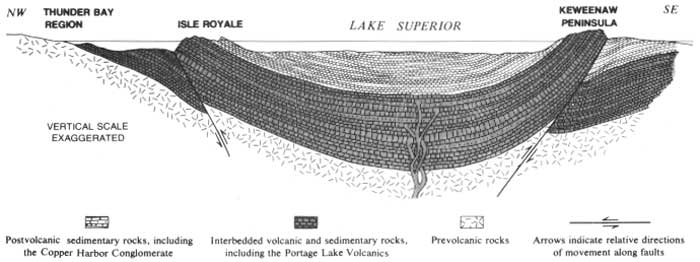
The orientation of the beds on the Keweenaw Peninsula is a mirror image of that on Isle Royale. The bedrock sequence, similar to that on Isle Royale, generally dips northwestward toward the axis of the Lake Superior basin. Recognition of these similarities permitted C. T. Jackson to state as early as 1849 that "this island has the same geological character as Keweenaw Point, and is of the same geological age." He and his colleagues, J. W. Foster and J. D. Whitney, furthermore considered the rock sequences in the two areas to be connected beneath Lake Superior and thus interpreted the lake as occupying a structural basin, a syncline, as well as topographic depression (fig. 38).
|
| LAKE SUPERIOR BASIN—cross section. (Fig 38) (click on image for an enlargement in a new window) |
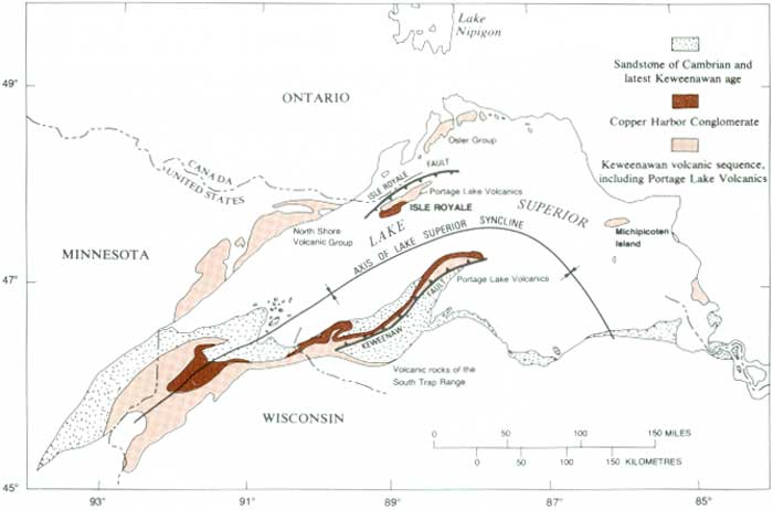
The later work of A. C. Lane not only reinforced this interpretation but also demonstrated that some individual lava flows or groups of flows, as well as some sedimentary rock units, on Isle Royale were the same as those on the Keweenaw Peninsula (fig. 39). The continuity of the Greenstone Flow across the Lake Superior basin is most convincing, and its name is used in both localities; specific correlation of other flows is less certain, and separate names are applied to them on opposite sides of the lake.
|
| LAKE SUPERIOR REGION—distribution of selected rock units. (Fig. 39) (click on image for an enlargement in a new window) |
The Portage Lake Volcanics on Isle Royale and on the Keweenaw Peninsula represent only the upper part of the total Keweenawan volcanic sequence in the Lake Superior region. The lower part of the sequence is exposed in the so-called South Trap Range of westernmost Michigan and along the north shore of Lake Superior in Minnesota and Ontario. Different formation names are given to these rocks in different areas (fig. 39). The total volcanic sequence reflects a long period of volcanic activity with a complex history. Erosional debris derived from the lower part of the volcanic sequence occurs in the sedimentary rocks interbedded with the lava flows of the Portage Lake Volcanics. The interpretation is that the lower part of the sequence was being eroded at the margins of a basin while the later flows were still being erupted into the central part of the basin.
| <<< Previous | <<< Contents >>> | Next >>> |
bul/1309/sec4c.htm
Last Updated: 28-Mar-2006