
|
Geological Survey Bulletin 1327
The Geologic Story of Canyonlands National Park |
EARLY HISTORY

Prehistoric people
There is abundant evidence that the canyon lands were inhabited by cliffdwellers centuries before the explorations of Powell or the earlier visits of the Spanish explorers and the fur trappers. Projectile points and other artifacts found in the near by La Sal and Abajo Mountains indicate occupation by aborigines from about 3,000-2,000 B.C. to about 1 A.D. (Hunt, 1956).
Archeologists have found evidence of two occupations by prehistoric peoples in and near Canyonlands National Park—the Fremont people around 850 or 900 A.D. and the Pueblo or Anasazi people from about 1075 to their departure in the late 12th century (Jennings, 1970). Within the park, the most densely populated area was along Salt Canyon and its tributaries in the Needles district, but many prehistoric dwellings and granaries are also found just south of the park in Beef Basin and Ruin Park.
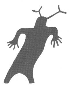
The Fremont people, who were mainly hunters, seemingly left no artifacts, but they did leave beautiful pictographs, or rock paintings, such as the group of ghostly human figures on the sandstone wall of Horseshoe Canyon (fig. 2), in the detached unit northwest of the park proper (fig. 1). The All American Man (fig. 3), a most unusual "Humpty Dumpty" figure painted in red, white, and blue on the wall of a cave about 3-1/3 miles above the cable across the east fork of Salt Canyon, is believed to have been done in the Fremont style, but as shown in the photograph, it is next to one of three dwellings in the same cave that were built later by the Anasazi people. Tower Ruin (fig. 4) is one of many well-preserved granaries built by the Anasazi, who farmed the flood plains of creeks such as Salt and Horse Canyons. According to Jennings (1970),
There is some evidence that these early Utah people practiced a form of irrigation, using shallow ditches to carry water to their crops. There is also evidence that a change in climate sometime around the late 12th century brought about summer flash flooding and induced the cliff dwellers to abandon their Canyonlands homes and farms.

|
| PICTOGRAPHS ON WALL OF HORSESHOE CANYON, believed to have been made by Fremont people about 1,000 years ago. Numbered chalkmarks 1 foot apart along bottom were made by some previous photographer. Photograph by Walter Meayers Edwards, © 1971 National Geographic Society. (Fig. 2) |

|
| THE ALL AMERICAN MAN, on wall of cave in Cedar Mesa Sandstone Member of Cutler Formation along upper Salt Canyon, believed to have been painted by Fremont people. Granary on right was built by Anasazi people. Chalk outline was added by some previous photographer. Photograph by National Park Service. (Fig. 3) |

|
| TOWER RUIN, an Anasazi granary in cave in Cedar Mesa Sandstone Member along tributary of Horse Canyon. (Fig. 4) |
Visitors to the Needles district pass through Indian Creek State Park 12 miles west of U.S. Highway 163. The principal attraction, which is visible at the base of the Wingate Sandstone cliff on the right (north), is Newspaper Rock (fig. 5), one of the best preserved and most intriguing petroglyphs, or rock inscriptions, in the canyon lands. Many of the older cliff faces of the Wingate and Navajo Sandstones are darkened or blackened by desert varnish, a natural pigment of iron and manganese oxides. The prehistoric inhabitants of the canyon country learned that effective and enduring designs could be created simply by chiseling through the thin dark layer to reveal the buff or tan sandstone beneath. According to Jesse D. Jennings (letter of Mar. 20, 1962, to Utah Div. Parks and Recreation),
There are at least three periods of workmanship visible on the rock. The last is quite recent since it shows men mounted on horses [brought in by Spanish explorers]. These are probably less than 200 years old and are probably the work of Ute tribesmen. The others cannot be identified with any specific cultural group, although the earliest may be as much as one thousand years old and are probably the work of the so-called Fremont peoples * * *

|
| NEWSPAPER ROCK, petroglyphs cut in Wingate Sandstone cliff in Indian Creek State Park. Inscriptions probably span about 1,000 years and include figures by Fremont, Anasazi, and Ute people (mounted horsemen) and by a few early white settlers. (Fig. 5) |
In addition to the designs by the Fremont, Anasazi, and Ute artists, you will note a few names and dates as late as 1954.
Late arrivals
The modern history of Canyonlands is as colorful as the canyons themselves, and involves Indians, cattlemen, bank robbers, cattle rustlers, and horsethieves, followed by oil drillers, uranium hunters, potash miners, jeepsters, boaters, and tourists. A brief summary of their activities is taken mainly from a recent account by Maxine Newell (1970), to whose work you are referred for further details.
Bands of Ute and Navajo Indians roamed the canyons and mesas until the late 1800's, but gradually they were driven out and succeeded by pioneer cattlemen, the first of whom were George and Silas Green in 1874-75, followed by the Taylor brothers in 1880-81. Cowboys named many of the natural features of the area, and the Needles country provided the scenic background for some of Zane Grey's western tales and for David Lavender's "One Man's West." Lavender Canyon, whose headwaters were recently annexed to the park, was named for him. Visitors to the Needles district pass the Dugout Ranch about 7 miles northwest of Newspaper Rock. The earliest ranch dwellings were dirt houses built by the Somerville and Scorup brothers, who bought the huge Indian Creek spread for $426,000 from the Carlisle Co. in 1918. In 1973 the ranch was operated by Robert and Heidi Redd, whose line camp at Cave Spring served as temporary park headquarters and later was restored to a typical line camp (fig. 6) as part of the Cave Spring Environmental Trail.

|
| CAVE SPRING LINE CAMP. Above, line-camp exterior, showing entrance and corral; below, interior, showing furnishings and staple food items kept in stock. Served as regular cowboy line camp for many years, than as part of temporary park headquarters; later restored as part of Cave Spring Environmental Trail. A nearby cave, also in Cedar Mesa Sandstone, contains a spring. (Fig. 6) |
Robbers Roost Canyon and Spring some 30 miles west of the park was the hangout of a horsethief named Cap Brown in the seventies. From 1884 until about 1900 it was the hiding place for the notorious Butch Cassidy and his Wild Bunch, who robbed banks, trains, and mine payrolls and stole or traded horses and cattle from the ranchers. Cassidy and his gang managed to get along with the cattlemen by either replacing or paying for most of the horses and cattle, but the law finally drove them out, and Butch, the Sundance Kid, and a woman named Etta Place moved to Bolivia. According to the movie version, Butch and the Sundance Kid were hunted down and shot by Bolivian soldiers for robbing banks and mine payrolls, but according to Baker (1971) Butch returned safely to the United States and died in the Northwest in 1943 or 1944, and the Sundance Kid is reported to have died in Casper, Wyo., in 1958 at age 98. Art Ekker (Findley, 1971, fig. 3), present owner of Robbers Roost Ranch, which contains the former hangout, commented: "A lot of people are sure that Butch and his gang buried some money around Robbers Roost. Every so often somebody turns up with a map or a metal detector and wants to start digging. They've found a lot of rusty tin cans and old horseshoes."
The uranium boom of the 1950's, touched off by Charlie Steen's fabulous Mi Vida mine south of La Sal, Utah, temporarily skyrocketed the population of Moab and sent uranium hunters into every nook and cranny of the canyon lands. Many of the jeep trails were first made then, and landing strips and prospect holes of that period are plentiful. Most of the prospects were in the Chinle Formation, particularly in the Moss Back Member at the base, but some were in rocks older than the Chinle, and some were in younger rocks. The uranium mines in the park are no longer operating, but production has been resumed in a few mines just north and east of the park. Information on some of these mines, obtained from E. P. Beroni (U.S. Atomic Energy Comm., oral commun., Feb. 14, 1973) is given at appropriate places below.
The number of boaters or floaters on the Colorado and Green Rivers is increasing steadily, and trips by jet boat and other power boats are available from Moab. Tourist travel over good roads on Island in the Sky and Hatch Point and by paved road to The Needles also is increasing steadily. Travel west of the Green River and main stem of the Colorado River is still restricted largely to a few jeep trails and to hiking or horseback riding.
| <<< Previous | <<< Contents >>> | Next >>> |
bul/1327/sec3.htm
Last Updated: 28-Dec-2006