|
Geological Survey Bulletin 1327
The Geologic Story of Canyonlands National Park |
ROCK AND LANDFORMS

The vivid and varied colors of the bare rocks and the fantastic canyons, buttes, spires, columns, alcoves, caves, arches, and other erosional forms of the canyon country result from a fortuitous combination of geologic and climatic circumstances and events unequaled in most other parts of the world.
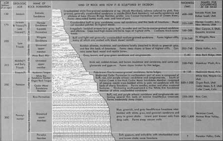
First among these events was the piling up, layer upon layer, of thousands of feet of sedimentary rocks under a wide variety of environments. Sedimentary rocks of the region are composed of particles ranging in size from clay and silt through sand and gravel carried to their resting places by moving water, silt and sand particles transported by wind, and some materials precipitated from water solutions, such as limestone (calcium carbonate), dolomite (calcium and magnesium carbonate), gypsum (calcium sulfate with some water), anhydrite (calcium sulfate alone), common salt (sodium chloride), potash minerals such as potassium chloride, and a few other less common types. Some of the materials were laid down in shallow seas that once covered the area (fig. 8) or in lagoons and estuaries near the sea. Some beds were deposited by streams in inland basins or plains, a few were deposited in lakes, and some, like the Navajo Sandstone, were carried in by the wind. The character and thickness of the sedimentary rocks, and the names and ages assigned to them by geologists, are shown in the rock column in figure 9 and in the cross sections in figures 10 and 15, and the history of their deposition is discussed in the chapter "Summary of Geologic History." The rock column was compiled mainly from generalized stratigraphic sections given by Baker (1933, 1946), McKnight (1940), Hinrichs and others (1967, 1971b), and F. A. McKeown and P. P. Orkild (U.S. Geol. Survey, unpub. data, Mar. 16, 1973).

|
| SHALLOW INLAND SEA which covered Canyonlands and vicinity during Middle Pennsylvanian time. (Fig. 8) |
Not exposed in the area but present far beneath the sedimentary cover, and exposed in a few surrounding places, are examples of the other two principal types of rocks: (1) igneous rocks, solidified from molten rock forced into or above younger rocks along cracks, joints, and faults and (2) much older metamorphic rocks, formed from other pre-existing rock types by great heat and pressure at extreme depths. The particles comprising the sedimentary rocks were derived by weathering and erosion of rocks of all three types in the headwater regions of the ancestral Colorado River basin. Igneous rocks of Tertiary Age (fig. 80) form the nearby La Sal, Abajo, and Henry Mountains (fig. 7).
Second among the main events leading to the formation of the canyon country was the raising and buckling of the Plateau by earth forces so that it could be vigorously attacked by various forces of erosion and so that the rock materials thus pried loose or dissolved could eventually be carted away to the Gulf of California by the ancestral Colorado River. Some idea of the enormous volume of rock thus removed is apparent when you look down some 2,000 feet to the river from any of the high overlooks, such as Dead Horse Point (fig. 15) or Green River Overlook (fig. 23), or when you lay a straightedge across the three high mesas in figure 10 and note the large volume of missing rocks below. Not so apparent, however, is the fact that some 10,000 feet of younger Mesozoic and Tertiary rocks that once overlay this high plateau also has been swept away. In all, the river has carried thousands of cubic miles of sediment to the sea and is still actively at work on this gigantic earthmoving project. In an earlier report (Lohman, 1965, p. 42) I estimated that the rate of removal may have been as great as about 3 cubic miles each century. For a few years the bulk of it was dumped into Lake Mead, but now Lake Powell is getting much of it. When these and other reservoirs ultimately become filled with sediment, for reservoirs and lakes are but temporary things, the Gulf of California will again become the burial ground.
Last but far from least among the factors responsible for the grandeur of the canyon country is the desert climate, which allows us to see virtually every foot of the vividly colored naked rocks and has made possible the creation and preservation of such a wide variety of fantastic sculptures. A wetter climate would have produced a far different and smoother landscape in which most of the rocks and land forms would have been hidden by vegetation. In the canyon lands the vegetation is mainly on the high mesas and on the narrow flood plains bordering the rivers, but scanty vegetation does grow on the gentle slopes or flats.

|
| ROCK COLUMN OF CANYONLANDS NATIONAL PARK. One foot equals 0.305 meter. (click on image for an enlargement in a new window) (Fig. 9) |
The desert climate has combined with the nearly flat lying layers of sediments of different character, hardness, and thickness to produce steep slopes having many cliffs and ledges and generally sharp to angular edges rather than the subdued rounded forms of more humid regions. This has led geologists to refer to such terrain as having "layer-cake geology," and this is brought out by the profile in the rock column (fig. 9), by the cross section (fig. 10), by figure 15, and by many of the other photographs. But the baker of this cake was rather careless—not only do the layers range widely in thickness and character, but some are wedge shaped, thick on one side of the cake but thin or absent on the other. Then too, when he ran out of icing in the midst of a layer, he was apt to finish with a different kind or color, for no inspector was on the job to insure orderly construction.
If all the rock strata in the park were present at one locality, their sequence and thickness would be those shown on the right-hand side of the graphic section in figure 9. However, because of the lateral changes in thickness and character and the wedging out of certain beds, such as the White Rim Sandstone Member of the Cutler Formation, no two sections of the strata are exactly alike. This will be brought out in photographs of different exposures of rocks in various parts of the park.
An often-asked question is, why are most of the rocks so red? This can be answered by one word—iron, the same pigment used in rouge and in paint for barns and boxcars. Various oxides of iron, some including water, produce not only brick red but also pink, salmon, brown, buff, yellow, and even green or bluish green. This does not imply that the rocks could be considered as sources of iron ore, for the merest trace of iron, generally only 1 to 3 percent, is enough to produce even the darkest shades of red. The only rocks in the park that contain virtually no iron are white sandstones of the White Rim Sandstone Member of the Cutler Formation (figs. 21-24) and the Navajo Sandstone.
As pointed out by Stokes (1970, p. 3), microscopic examination of the colored grains of quartz or other minerals shows the pigment to be merely a thin coating on and between white or colorless particles. Sand or silt weathered from such rocks soon loses its color by the scouring action of wind or water, so most of the sand dunes and sand bars are white or nearly so.
The map (fig. 1) and cross section (fig. 10) of the park show that in general the major features of the landscape lie at three different and distinctive levels. A recently erected plaque on Grand View Point appropriately refers to these levels as the "Three Worlds." The high plateaus, or mesas, in and adjoining the park dominate the skyline—in fact, the central one, between the Green and Colorado Rivers, is appropriately named Island in the Sky. If you stand on either the east or the west shore of this towering cliff-bordered island, you can look across a sea of fantastic erosional forms to a similar cliff-bordered shore at about the same level. Closer inspection of the sea of rocks on either side shows relatively flat benches or platforms about halfway to the bottom; below these are the generally steep-sided or cliff-bordered canyons of the two rivers and their larger tributaries. From some vantage points along the shore, such as Dead Horse Point (fig. 15) or Green River Overlook (fig. 23), you can see the deepest level of all—the channels and flood plains of the Green and Colorado Rivers.
What caused the "Three Worlds" and the formidable cliffs supporting the high mesas or forming towering monoliths like Angel Arch or Druid Arch (figs. 43, 54)? Differences in the composition, hardness, arrangement, and thickness of the rock layers determine their ability to withstand the forces of fracturing and erosion and hence their tendency to form cliffs, ledges, or slopes. Most of the cliff- or ledge-forming rocks are sandstones consisting of sand grains deposited by wind or water and later cemented together by silica (SiO2), calcium carbonate (CaCO3), or one of the iron oxides (such as Fe2O3), but some hard, resistant ledges are made of limestone (calcium carbonate). The rock column (fig. 9) shows in general how these rock formations are sculptured by erosion and how they protect underlying layers from more rapid erosion. The nearly vertical cliffs supporting the highest mesas consist of the well-cemented Wingate Sandstone protected above by the even harder sandstone of the Kayenta Formation. To borrow from an earlier report of mine (Lohman, 1965, p. 17),
vertical cliffs and shafts of the Wingate Sandstone endure only where the top of the formation is capped by beds of the next younger rock unit—the Kayenta Formation. The Kayenta is much more resistant than the Wingate, so even a few feet of the Kayenta * * * protect the rock beneath.
In some places remnants of the overlying Navajo Sandstone make up the topmost unit of the cliff.

| <<< Previous | <<< Contents >>> | Next >>> |
bul/1327/sec5.htm
Last Updated: 28-Dec-2006
