
|
THE RIVER AND THE ROCKS
The Geologic Story of Great Falls and the Potomac River Gorge |
TRAIL LOG—BEAR ISLAND (optional)
| Mileage | SHRUBS AND SMALL TREES | |||||||
| 0.19 |
(About 400 paces.) The towpath passes high above an intermittent river channel encircling Rocky Islands. Nearly dry in the low-water stages of summer and fall, this channel is often filled to a depth of 40 feet by winter and spring floods. Notice the small shrubs growing in rocks at the bottom of the channel. These are sycamore, river birch, and ash that normally grow to be large trees, but here they are kept small by the frequent battering of flood torrents. |
| ||||||
| 0.28 |
(About 190 paces.) Trail junction; follow marked trail to right along west side of Bear Island. Towpath straight ahead follows C. and O. Canal 1.6 miles to Widewater and MacArthur Blvd. Along the trail and to your right are many bent trees that were felled by the March 1936 flood which was 10-15 feet deep along the trail. The prominent levee constructed of rock debris to the left of the trail was designed to divert floodwaters from the canal bed and return them to the main channel of the Potomac. | |||||||
| ||||||||
| 0.49 |
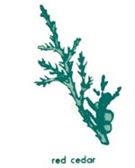
(About 440 paces.) Stop G5. Trail crosses a narrow valley cut along easily eroded dikes of lamprophyre. Turn right and follow valley for 70 feet to the overlook at outcrop of dark-green lamprophyre. Across the river, diagonally upstream, notice a series of vertical clefts in the steep rock wall of the gorge. These clefts are the continuation of the lamprophyre dikes on which you are standing. Notice that they are not directly on the trend of the narrow valley projected across the river, but are about 80 feet upstream from where you would expect to find them. The rocks on the two sides of the river have slid past each other along a major fracture, called a fault, which lies beneath the river at this point. The straight steep-sided gorge that stretches downstream is cut in the crushed and broken rocks along the fault. This fault zone is more easily eroded than the solid rocks on either side. The trail between Stops G5 and G6 passes in and out of a red oak and post oak forest typical of this bedrock terrace. Other trees are white and chestnut oaks, pignut hickory, Virginia pine, and redcedar which is used to make cedar chests. |
| ||||||
| 0.81 |
(About 680 paces.) Stop G6. For about 150 yards, the trail weaves among ribs and knobs of quartzose mica schist along the top of the present river gorge. Many large potholes can be seen along the trail. The prominent bench at this elevation—best seen on the other side of the gorge—is a bedrock terrace which marks the ancient riverbed before the gorge was eroded. The potholes were cut by the grinding action of rocks trapped by current eddies. (See Stop G2, Maryland trail log.) One contains a large boulder of rusty-brown diabase; the nearest outcrop of diabase along the river is near Blockhouse Point, more than 7 miles upstream, and this boulder must have been carried at least that far by the river. This stop also provides an excellent view of this part of Mather Gorge which is a remarkably straight steep-sided gorge cut in the crushed rocks along the fault. On the walls of the gorge, horizontal color bands produced by different species of lichens and by chemical staining reflect different levels of flooding. (See Stop G4, Virginia trail log.) |
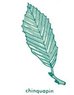
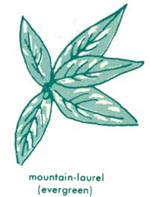
RARE TREES 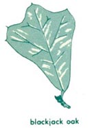
| ||||||
| 0.96 |
(About 320 paces.) Trail crosses a small valley eroded along a fracture zone. Rocks in brook bed are heavily stained with iron, probably from sulfides deposited long ago by solutions percolating along the fracture zone, then dissolved by the brook as it cuts its way down into the crushed rocks, and then reprecipitated. The white-barked trees are sycamore growing with ash, elm, and box elder on fine soil deposited on flood plains by high water. A little-used trail turns left along east side of brook, and leads 0.25 mile to C. and O. Canal and another 0.96 mile back to Great Falls Tavern Visitor Center. Continue across valley and up cleft in rock slabs. |
| ||||||
| 1.21 |
(About 530 paces.) Stop G7. Straight ahead, a prominent plug of light-colored granite and several smaller granite dikes intrude a thick sheet of dark-green amphibolite which us rusty brown on weathered surfaces. The amphibolite was formed by the metamorphism of basaltlike rock. The dark stubby crystahs visible on weathered surfaces of the amphibolite are clusters of hornblende replacing crystals of pyroxene in the original rock. Just upstream from the amphibolite, numerous beds of metagraywacke 1 to 8 inches thick and a 5-foot sheet of amphibolite are interlayered with mica schist. These rocks display many of the details of the folding and metamorphism outlined earlier. Most rocks display a prominent schistosity parallel to the layering; a few contain the early folds which produced the schistosity. Hornblende clusters in the amphibolite are strung out parallel to the schistosity, showing that the amphibolite must have been intruded and metamorphosed before the folding. The rocks are cut by many thin veinlets of quartz, most of which are intricately folded (as shown in photograph), and must have formed prior to the folds and the schistosity. But the small veins and irregular pods of light-colored coarse-grained granite cut across the schistosity, showing that the granite must have been intruded after the folding. Several of the mica schist layers contain elongated 2-inch crystals of light-colored kyanite; they too must have formed after the folding, because they clearly pushed the schistosity aside as they grew. Return to the trail, and continue south eastward (downstream). |
| ||||||
| ||||||||
| 1.34 |
(About 275 paces.) Stop G8. This outcrop shows a good example of one of the late folds, in which the early schistosity, parallel to the metagraywacke layers, is bent, and a second, weaker schistosity has formed at an angle to the first. From here the trail descends into a small valley which follows the sinuous form of a folded amphibolite sheet, more easily eroded than the schists and metagraywackes on either side. This fold is a larger scale example of the late folds, like the small one shown below. Across the pond from the trail, sycamore, boxelder, ash, and silver maple trees are growing on fine soil deposited by the Potomac River during high water. |
| ||||||
| ||||||||
| 1.49 |
(About 320 paces.) The trail crosses a small stream on a plank bridge. Side trails on both banks of the stream turn left to Widewater and the C. and O. Canal. Continue straight ahead over low rock ledge, following marked trail. |

| ||||||
| 1.67 |
(About 380 paces.) Stop G9. After the trail drops off a bedrock ridge it turns northward toward the C. and O. Canal. Shortly thereafter it dips into a valley containing an elongated pond to your left. This part of the trail is impassable during floods because water flows from the river northward. Note the flood debris that litters the valley bottom, and that is caught on the south sides of shrubs and tree trunks. Many trunks lean to the north, showing that high water flows from the river to your right and sweeps around the hill in front of you. After the trail passes over the hill it again dips into a narrow valley which is the extension of the valley at Stop G9. Note here that flood debris on shrubs and trees and leaning trunks show that high water flowed from your left to the river on your right. |
| ||||||
| ||||||||
| 1.92 |
(About 530 paces.) Trail emerges on the C. and O. Canal at Widewater. Follow towpath to the left 1.55 miles to return to Great Falls Tavern Visitor Center. To the right, the towpath leads 0.51 mile to parking lot at MacArthur Boulevard. |
| ||||||
| <<< Previous | <<< Contents >>> | Next >>> |
bul/1471/sec8.htm
Last Updated: 01-Mar-2005


