|
THE RIVER AND THE ROCKS
The Geologic Story of Great Falls and the Potomac River Gorge |
TRAIL LOG—GREAT FALLS, MARYLAND
This walking tour is designed to acquaint you with the important geological features that can be seen from the park trails. To help you find the stops that are indicated, small light-colored oval signs have been placed in strategic places to point your way. At each stop there will be similar signs that have the stop number on it. Length 1 mile. Optional Bear Island trail 3.5 miles.
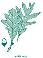
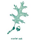
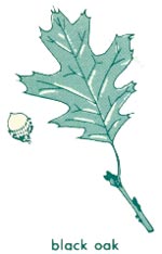
| Mileage | PIEDMONT UPLAND TREES | |||||||
| 0.00 |
Leave Great Falls Tavern Visitor Center, cross C. and O. Canal. Turn left (downstream) on towpath. The low dam across the river diverts about 2,500 gallons of water per second into an underground aqueduct which empties into Dalecarlia Reservoir 9 miles away. The water is then used by the District of Columbia and nearby suburbs. The reddish rock used in the canal locks is sandstone of Triassic age that was quarried near Seneca, 9 miles above Great Falls. This "Seneca Stone" was used in the construction of many of the older buildings in Washington. |
| ||||||
| 0.27 |
(About 570 paces.) Trail junction 80 yards beyond lower end of Lock 18. Turn right on the Great Falls Trail. | |||||||
| 0.32 |
(About 110 paces.) Cross footbridge over narrow channel of river onto Olmsted Island. | |||||||
| 0.34 |
(About 40 paces.) Stop G1. The rocks and the river. The rock exposed here is mica schist. Originally deposited as mud on the ocean bottom, it was converted to schist by high temperatures and pressures during burial deep within the earth's crust. The knots and veinlets of white quartz were "sweated" out during this metamorphism. The paper-thin layers, reflecting the original sedimentary layers, have been crumpled and folded, producing a wavy appearance on some of the rock faces. Many small trees in this vicinity have been overturned by floods. Notice how the vertical stems (really branches) have sprouted from the prostrate trunks. To determine the time of the floods, a tree was cored at the base of the stem and the rings counted. Most of these trees were damaged during the 1936 flood. | |||||||
| 0.37 |
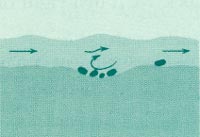
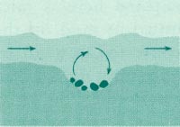
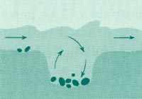
(About 60 paces.) Stop G2. Part of the former riverbed. The large circular holes in the rock are potholes. They were ground in the rocks by pebbles and cobbles churned in rapids when this area was part of the river bottom. All of the rocks exposed in this area were smoothed and polished by the river at that time. Although an occasional flood still reaches this level, the potholes and water smoothed rocks date from a much earlier stage, prior to the cutting of the gorge and formation of the falls. From here to the over look at the falls you will be walking over part of this ancient riverbed. |
| ||||||
| ||||||||
| 0.54 |
(About 360 paces.) Stop G3. A relict of the river. This boulder, about 2 feet in diameter, is composed of coarse-grained white quartzite of a type that is found at Harpers Ferry and at Point of Rocks. It must have been carried downstream at least 25 miles when the river flowed at this level. Many other pebbles and boulders scattered throughout this area were transported from sources many miles upstream. |
 SHRUBS AND SMALL TREES 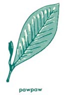   
| ||||||
| 0.57 |
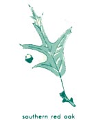
(About 60 paces.) Stop G4. A closeup view of Great Falls. The total drop here at normal stages of the river is about 40 feet. The highest cascades are about 16 feet. The distance froun here to the overlooks on the Virginia shore is about 500 feet. In the narrowest part of the channel below the falls the river is about 75 feet wide at normal stages, but at higher stages it floods to the base of the cliff below you. About once every 2 years floods cover this overlook to depths of 1 to 2 feet. Some of the scattered shrubs growing among the rocks below are sycamore and river birch that normally grow to be large trees. Here they are kept small and shrubby by frequent flood damage. The detergent suds commonly seen in the river just below the falls are evidence of pollution from towns and cities upstream. Notice the broad flat surface at the top of the cliffs on the Virginia side. This is part of the same ancient riverbed across which you have been walking. This ancient river bed, which lies 40 to 50 feet higher than the river below the falls, can be traced upstream to the present level of the river above the falls. The river occupied this bed before the gorge was cut and the falls were formed. The forest on the old riverbed downriver from the falls is different from that on the same surface upriver from the falls. This trail passed through a red oak and post oak forest with pine, juniper, pignut hickory, and a few other species. Upriver, this surface stupports a sycamore and ash forest with river birch, silver maple, boxelder, and cottonwood. Red and post oaks are not present. The rocks here are chiefly metagraywacke (a type of metamorphosed sandstone). On the outcrop directly east of you is an 8-inch-thick layer of metagraywacke interlayered with mica schist. Some of the larger original sand grains are visible in the lower part of the layer. When these layers were deposited, they lay nearly horizontal on the sea bottom, but they were crumpled into folds at the time the rocks were deeply buried and metamorphosed. The many knots and layers of white quartz were sweated out of the rocks during metamorphism and outline some of these folds. Notice the schistosity cutting across the layers. The straight fractures or joints displayed in the rocky islands in the river were formed when the rocks were uplifted. The most conspicuous joints are nearly vertical and perpendicular to the folded rock layers. Notice how these structures control the details of the falls. The several river channels tend to closely parallel the rock layers, and the cascades or steps occur where the channels cross a closely spaced group of joints. Continue along trail for about 30 yards to lower overlook. Note conspicuous folds in rock layers to the right 15 feet beyond the lower overlook guardrail. | |||||||
| ||||||||
| 0.66 |
(About 190 paces.) Trail intersection. Turn right and return along trail to towpath. |
| ||||||
| 0.91 |
(About 530 paces.) C. and O. Canal towpath. From this point you may turn left and return the 0.27 mile to the starting point. The remainder of the hike is over rough secondary trails suitable for experienced hikers only. If you elect to continue, turn right along the towpath to the Bear Island ("Billy Goat") Trail. | |||||||
| <<< Previous | <<< Contents >>> | Next >>> |
bul/1471/sec7.htm
Last Updated: 01-Mar-2005
