
|
Geological Survey Bulletin 1508
The Geologic Story of Colorado National Monument |
HOW TO SEE THE MONUMENT
HOW TO SEE THE MONUMENT depends in large part on how long you can stay, but it depends also upon the direction you are traveling to or through Grand Junction and Fruita, and on the mode of transportation. Moreover, the Monument has four entrances—two main entrances from Fruita (West Entrance) and Grand Junction (East Entrance), and two subordinate entrances from the Glade Park area to the southwest.
Though by no means as well known as our large National Parks, Colorado National Monument is more readily accessible than many. It is on two transcontinental highways (U.S. 6 and 50), is the western terminus of U.S. 24, and is on nearly completed Interstate 70, one of the most scenic transcontinental Interstate Highways. Highway I-70 supersedes many stretches of U.S. 6, 24, and 50, but the latter are still used in parts of the Grand Valley and elsewhere. The Monument also is on the main line of the Denver and Rio Grande Western Railroad, which still maintains limited passenger service between Denver and Salt Lake City, but this service may eventually be terminated. Grand Junction's Walker Field is served by several airlines, and both Grand Junction and Fruita are served by busses.
Many people driving through the Grand Valley for the first time are unaware of the Monument's existence unless they happen to see it on a roadmap or see road signs pointing toward it, but unfortunately the signs are unevenly and poorly distributed. People entering Grand Junction from the east on U.S. 6 and 24 or from the southeast on U.S. 50 are apt to see one or more of the signs—particularly when crossing Grand Avenue on First or Fifth Streets. If they are heading westward and can devote at least half a day, they may drive to the East Entrance, follow Rim Rock Drive for 22 miles northwestward through the Monument, stop at some or most of the scenic overlooks and the Visitor Center, leave via the West Entrance, and proceed northwestward on U.S. 6 and 50 or better yet on I-70. However, as will be described below, longer stops are much more rewarding. Those driving eastward on I-70 may see the sign at the Fruita interchange pointing southward toward the Monument—and may take the above described quickie trip in reverse. Those heading northwestward on I-70, however, may not be aware of the Monument until they see the sign at the Fruita interchange; then, they may not have or take time to double back southeastward through the Monument. If they do drive southeastward through the Monument, however, they can return to Fruita following a very scenic northwesterly route through The Redlands on Broadway (Colo. Highway 340) and South Broadway, or they may take a paved shortcut from near the East Entrance to South Broadway via South Camp Road (p. 118). Drinking water and sanitary restrooms are available in the headquarters area in the campgrounds and picnic grounds and Visitor Center, and in the Devils Kitchen Picnic Area. Food is not available in the Monument, so those planning to remain all day should bring lunches.
I have conducted many groups through the Monument, always choosing to travel northwestward from Grand Junction through The Redlands, just northeast of the Monument, to the West Entrance, then returning southeastward through the Monument.28 On most days, taking the trip in these directions affords good lighting for photographing most of the scenic features. This and other routes are described in the next section and are plainly labeled so that the visitor may start with any trip he or she chooses. Regardless of how long you stay or which routes you follow, it is advisable to be well supplied with color film.
28Lohman, 1960, p. 66-100, 88-91.
Some of the view points and overlooks have displays or signs to help interpret the scenic features, and more of these aids are added from time to time.
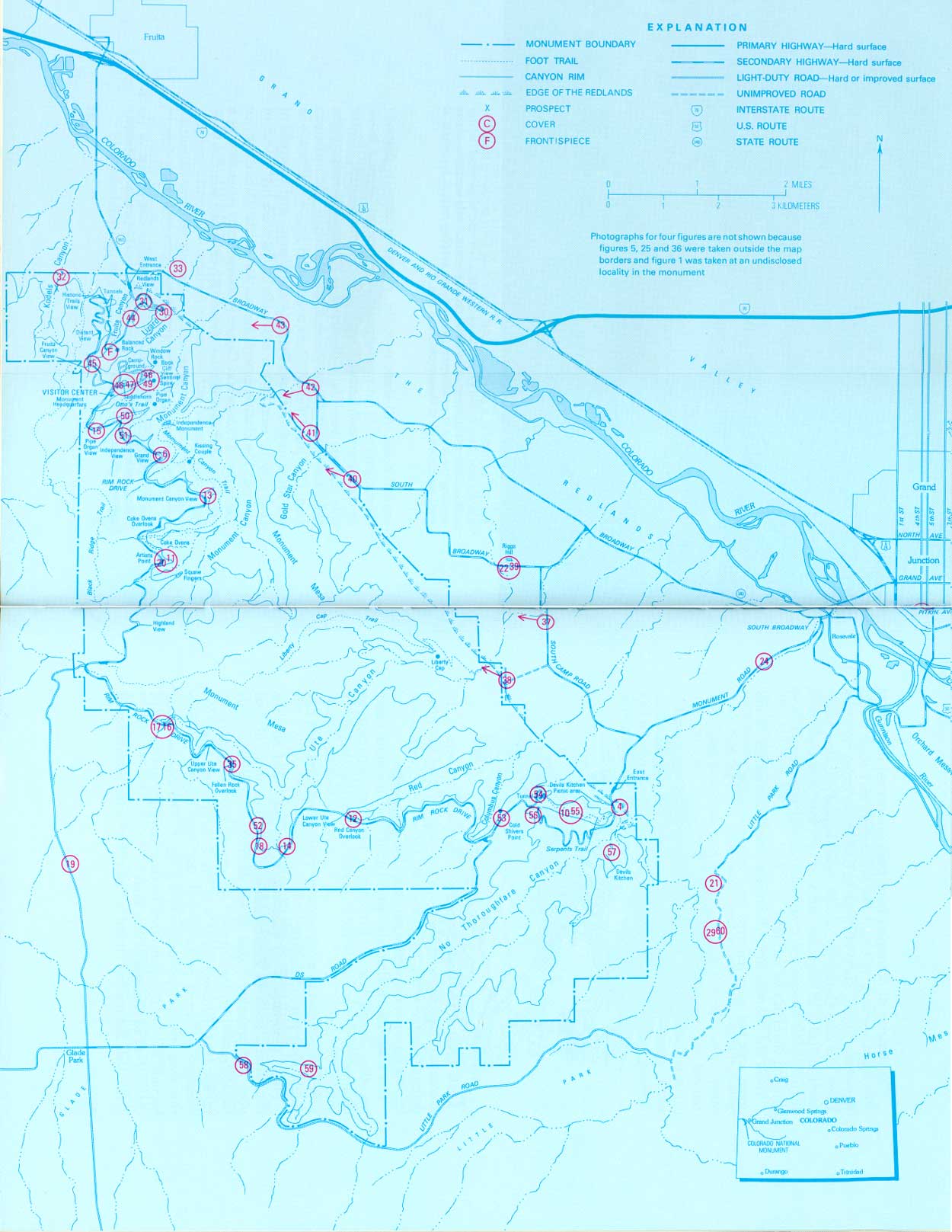
There are three maps in this report (figs. 3, 8, 26); these maps will be helpful to anyone touring the Monument. Figure 3 shows streams, highways and roads, principal trails, named features, overlooks, and trip-guide locations; figure 8 is a geologic map; and figure 26 shows localities where most of the photographs were taken. In addition, topographic maps of the Monument and adjacent areas by the U.S. Geological Survey, scale 1:24,000, are available from several sources and are a considerable aid to visitors. In addition to cultural and drainage features, such maps show the exact shape of the land by means of contour lines, which are level lines that go in and out of canyons, around ridges, and so forth. A special map of the Colorado National Monument quadrangle is available also in a shaded relief edition, which gives a three dimensional effect by proper shading of canyons and ridges. Both types of maps are for sale at the Visitor Center, and these and adjacent quadrangles, such as the Grand Junction, Fruita, Glade Park, and Island Mesa, are sold at several engineering and stationery stores in Grand Junction and at the U.S. Geological Survey's Map Distribution Office, Building 41, Federal Center, Denver, Colorado, 80225. The latter office and the Visitor Center also sell copies of my "Geologic Map of the Grand Junction area, Colorado," published in 1963 as Miscellaneous Investigations Map I-404.
|
| PHOTO INDEX MAP (overleaf), showing localities where most of the photographs were taken. Arrows point to distant views. Numbers refer to figure numbers. (click on image for an enlargement in a new window) (Fig. 26) |

| <<< Previous | <<< Contents >>> | Next >>> |
bul/1508/sec11.htm
Last Updated: 8-Jan-2007