|
Geological Survey Bulletin 1508
The Geologic Story of Colorado National Monument |
TABLE OF CONTENTS
Early history of the region
Prehistoric people
Late arrivals
Early settlement
The Brown-Stanton river expedition
Kodel's gold mine
Recent cave dweller
The geologic story begins
Ancient rocks and events
A great gap in the rock record
The age of reptiles
Early landscape
Ancient sand dunes
The rains came
Another gap in the rock record
The sea to the west
Deposits and events east of the sea
Dinosaurs roam the Monument
Dinosaurs on the move
Yet another gap in the rock record
Peat bogs
The sea covers the Plateau
The sea's final retreat
End of the dinosaurs
The age of mammals
Early deposits and events
Lake Uinta
The mountains rise again
Nearby lava flows
Ancestral Colorado River
Piracy on the high plateaus
The age of man
The ice age
Capture of East Creek
Canyon cutting
A look into the future
Trips through and around the Monument
From Grand Junction through the Redlands to the West Entrance of the Monument
From Fruita to the West Entrance of the Monument
Through the Monument from West to East Entrances
From the East Entrance to Grand Junction
Through Glade Park from the northwest arm of Ute Canyon to Columbus Canyon
From Glade Park to Grand Junction via the Little Park Road
Index (omitted from the online edition)

|
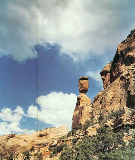
| BALANCED ROCK, near head of Fruita Canyon. Spire and rock are Wingate Sandstone resting on red Chinle Formation; thin caprock is protective layer of resistant Kayenta Formation. (Frontispiece) |
ILLUSTRATIONS
FIGURE
FRONTISPIECE. Balanced Rock1. John Otto
2. John Otto's Monument
3. Map of Colorado National Monument
4. Petroglyphs
5. Cave
6. Independence Monument
7. Rock Column of Colorado National Monument
8. Geologic Map
9. Block diagrams of early Proterozoic events
10. Petrified sand dunes
11. The Coke Ovens
12. Red Canyon
13. Thin-bedded Kayenta Formation
14. Kayenta Formation
15. Gap in the rock record
16. Entrada Sandstone
17. Moab Member of Entrada Sandstone
18. Mottled salmon-and-white Slick Rock Member
19. White Entrada Sandstone
20. Summerville Formation
21. Morrison Formation
22. Excavating type specimen of Brachiosaurus altithorax Riggs
23. Skeletons of typical dinosaurs of Morrison Formation
24. Burro Canyon Formation and Dakota Sandstone
25. Mount Garfield
26. Photo index map
27. Common types of rock folds
28. Common types of faults
29. Ladder Creek monocline and Redlands fault
30. Lizard Canyon monocline
31. Kodels Canyon fault
32. Kodels Canyon fault
33. Geologic structures at Fruita entrance to Colorado National Monument
34. Probable drainage patterns and land forms near the Monument at four successive stages of development
35. Fallen Rock
36. Unaweep Canyon
37. Redlands fault
38. Closeup of updragged Wingate Sandstone along Redlands fault
39. Bronze plaque and monument marking the discovery of Brachiosaurus altithorax Riggs
40. Reverse part of Redlands fault
41. Northwest end of Redlands fault
42. Looking west into Monument Canyon
43. Looking west from divide on Broadway 2 miles east of West Entrance to Monument
44. New fill on Rim Rock Drive between two tunnels on west side of Fruita Canyon
45. Fruita Canyon
46. Campsites at north end of campground
47. Picnic area and parking lot
48. Window Rock
49. Pipe Organ
50. Visitor Center and the Saddlehorn
51. Independence Monument
52. Ute Canyon
53. Cold Shivers Point
54. Top of old Serpents Trail
55. Looking northeast from old Serpents Trail
56. South portal of tunnel through Wingate Sandstone
57. Devils Kitchen
58. Glade Park fault viewed from the ground
59. Glade Park fault viewed from the air
60. Ladder Creek monocline and Redlands fault
61. Geologic time spiral
UNITED STATES DEPARTMENT OF THE INTERIOR
JAMES G. WATT, Secretary
GEOLOGICAL SURVEY
Doyle G. Frederick, Acting DirectorLibrary of Congress Cataloging in Publication Data
Lohman, Stanley William, 1907-
The geologic story of Colorado National Monument.
(Geological Survey Bulletin 1508)
Bibliography: p. 131
Includes index.
1. Geology—Colorado National Monument. 2. Colorado National Monument.
I. Title. It. Series: United States Geological Survey Bulletin 1508
QE75.B9 no. 1508 [QE92.C61 557.3s [557.88'17] 80—607952
| <<< Previous | <<< Contents >>> | Next >>> |
bul/1508/index.htm
Last Updated: 8-Jan-2007