
|
Geological Survey Bulletin 1508
The Geologic Story of Colorado National Monument |
THE AGE OF MAMMALS
THE BEGINNING of the Cenozoic Era 65 million years ago—give or take a few million years—marked the beginning of a long span of geologic time during which mammals became the ruling land animals. Remains of some small primitive mammals have been found in Mesozoic rocks (p. 50), but these tiny newcomers did not have a chance to flourish until the formidable dinosaurs died out.
The Cenozoic Era is divided into the long Tertiary Period—The Age of Mammals—and the short (about 2 million years) Quaternary Period—The Age of Man. The Tertiary in turn is divided into five epochs—the Paleocene, Eocene, Oligocene, Miocene, and Pliocene (fig. 61). Events during parts of the Tertiary Period had an important bearing upon the Monument even though no rocks of this period now occur in the area.
Early Deposits and Events
THE BROAD INLAND BASINS that were formed late in the Cretaceous Period received sand, silt, and mud brought in by streams from the uplifted or folded areas. These materials became compacted into the Wasatch Formation—the red or pink rock from which Bryce Canyon National Park was sculptured. One such basin lay just northeast of the Monument. The Monument probably was covered by some of these stream deposits after the main basin was partly filled.
The mammals that roamed the area during the Paleocene Epoch were primitive, but more advanced forms appeared later, in Eocene time. Some of their fossil remains have been found in the Wasatch Formation in Plateau Creek Valley north of Grand Mesa and near Rifle, about 60 miles northeast of Grand Junction. The entire 5,000 feet of the Wasatch may be seen along U.S. Highway I-70 between the towns of DeBeque and Grand Valley, and much of it helps support towering Grand and Battlement Mesas.
Lake Uinta
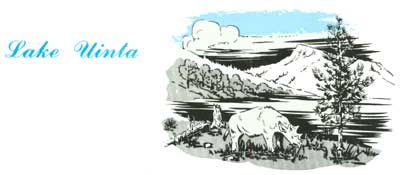
IN EOCENE TIME the northern part of the Colorado Plateau sagged downward and gradually filled with water until it became a huge lake, now known as Lake Uinta. The waters in it teemed with plants and animals, particularly micro-organisms such as algae, whose remains, coated with calcium carbonate, settled to the bottom along with the sand, silt, and mud washed into the lake by streams. These sediments compacted into the remarkable Green River Formation which contains, among many rock types, large deposits of rich oil shale.
The light-colored Green River Formation, which is about 3,800 feet thick, may be seen from U.S. Highway I-70 in the upper part of the towering Roan Cliffs on the northwest side of the Colorado River between DeBeque and Rifle. It also underlies the volcanic caprock of Grand and Battlement Mesas. John R. Donnell, of the U.S. Geological Survey, estimated that the oil shale in the Piceance Creek Basin, northwest of the Colorado River alone, contains more than one trillion barrels of oil. The Monument was at or near the south shore of this lake, and may have been covered with a few hundred feet of the Green River Formation.
The Mountains Rise Again
LAKES, LIKE MOUNTAINS, are temporary things. Even as lakes are forming, sediment begins to fill them until ultimately they are obliterated. So it was with Lake Uinta. Sometime after this lake dried up, the Earth's crust again became restless. The gentle folds that were formed late in the Cretaceous were lifted higher and bent more sharply, and the flanks of some folds were wrinkled and broken (figs. 27, 28). The sharply bent or broken rocks along the northeastern border of the Monument are thought to have been deformed mainly at this time, but in part both earlier and later. That pronounced folding of the rocks followed the deposition of the Eocene Green River Formation is clearly shown along the Grand Hogback monocline between the towns of Rifle and Meeker, Colorado, where the once flat lying beds of the Green River and Wasatch Formations now stand vertical.
|
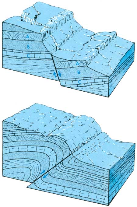
| COMMON TYPES OF FAULTS. Top, normal, or gravity, fault which generally results from tension in and lengthening of a segment of the Earth's crust, which allows the lower block to subside. However, some normal faults, particularly some that are vertical or nearly so, may result from uplift of the upper block. Low-angle reverse faults generally are called overthrust faults or simply overthrusts. In both the normal and reverse faults note amount of displacement and repetition of strata. Displacement of such faults may range from a few inches to many thousands of feet, and in overthrusts may reach many miles. From Hansen (1969, p. 116). (Fig. 28) |
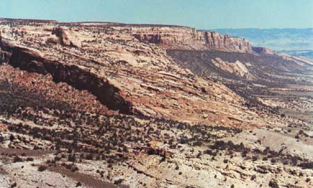
The folds and faults along the northeastern border of the Monument, which are shown on the geologic map (fig. 8), are discussed briefly here—more details are given later in "Trips through and around the Monument." The folded and faulted northeastern border of the Monument, which is shown in figure 29 and in several ensuing photographs, is believed to have resulted from renewed uplift of the area southwest of the folds and faults, including the Monument. The Redlands fault (figs. 8, 29, 37, 38, 40, 41) generally is a normal fault but locally is a reverse fault, as discussed on page 92 and as shown in figure 40 and in the cross section of figure 8. This fault has a maximum vertical displacement of 700 or 800 feet, but dies out in scissors fashion at each end. Beyond the end of the Redlands fault in the upper right of figure 29 may be seen another unbroken monocline. A close-up view of the northwestern end of this fold in shown in figure 30.
|
| LADDER CREEK MONOCLINE AND REDLANDS FAULT, telephoto view looking northwest from point near Little Park Road east of the Monument. No Thoroughfare Canyon in foreground, which is bordered on the left by northeastward-dipping beds of Wingate Sandstone at northwest end of Ladder Creek monocline. The old Serpents Trail, the lower part of which is barely visible, ascends this dipping block of rock. The dark Proterozoic rocks form the flat-topped bluff to the right and are exposed by the Redlands fault which lies just above the sharply upturned remnants of the Wingate Sandstone. (Fig. 29) |
|
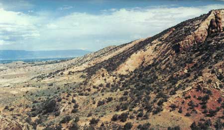
| LIZARD CANYON MONOCLINE, looking southeastward across mouth of Lizard Canyon from southeasternmost loop of Rim Rock Drive just before it ascends Fruita Canyon. Note gentle lower bend at lower left and sharper upper one at upper right. Lower bend changes to Kodels Canyon fault in Fruita Canyon behind camera station. Grand Mesa forms left skyline. (Fig. 30) |
If we proceed about a quarter of a mile northeast of the point from which figure 30 was taken, walk about 50 feet north, and look to the northwest, we see quite a different structure, for here the gentle lower fold of the Lizard Canyon monocline has become the east end of the Kodels Canyon fault (fig. 31).
|
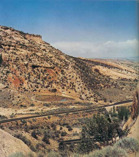
| KODELS CANYON FAULT, looking northwest across mouth of Fruita Canyon from point on Rim Rock Drive just described in text. Here, along a normal fault dipping steeply northeastward, the 350-foot cliff of Wingate Sandstone at upper left has been sheared and squeezed into only a few feet of broken rock overlain by a steep slope of the Kayenta Formation covered by piñon and juniper. The thinner cliff at right is the Entrada Sandstone which belongs high atop the cliffs at left. Book Cliffs form distant skyline at right. (Fig. 31) |
If you doubt that figure 31 shows a fault, a glance at figure 32 in the next major canyon eight-tenths of a mile to the northwest should convince you. Here, on the northwest side of Kodels Canyon, the Wingate was not thinned but was rent completely asunder by the vertical Kodels Canyon fault (fig. 32). Kodels Canyon is not readily accessible to visitors.
|
| KODELS CANYON FAULT, looking northwestward across canyon of same name. Base of Wingate cliff on left is just about opposite the top of the Wingate on right. Here, nature was kind to the geologist, for the vertical displacement (rise of left side with respect to right side) is virtually the thickness of the Wingate Sandstone—about 350 feet. The Wingate on the right is lighter colored than that on the left seemingly because rockfalls removed desert-varnish-coated rocks and exposed the true color of the sandstone. (Fig. 32) |
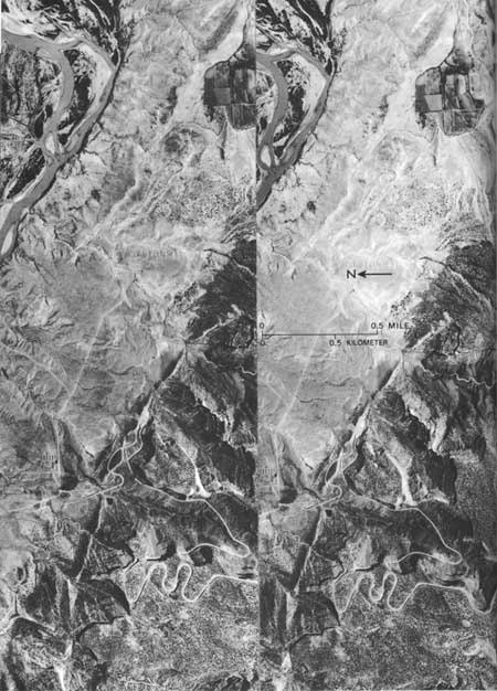
The Lizard Canyon monocline, Kodels Canyon fault, and other structures are clearly shown in the stereoscopic pair of aerial photographs in figure 33.
|
| GEOLOGIC STRUCTURES AT FRUITA ENTRANCE TO COLORADO NATIONAL MONUMENT. The stereoscopic pair of aerial photographs may be viewed without optical aids by those accustomed to this procedure, or by use of a simple double-lens stereoscope, such as the folding ones used by the armed forces during and after World War II. Geologic details may be identified by comparing photographs with the geologic map, figure 8. If viewer is unable to see stereoscopic pairs in three dimensions, looking at either photograph alone will convey a good idea of the geologic structure. The monocline near top of the photographs may be seen on the right-hand side of the highway in figure 43. Photographs taken in 1937 by U.S. Soil Conservation Service, hence, alinement of then unpaved Colorado Highway 340 differs from the paved present highway. (Fig. 33) |
Another structural feature within the Monument is the Glade Park fault (fig. 8), which lies mainly south of the Monument but just cuts across the south end of No Thoroughfare Canyon in the latest addition to the Monument. It is well shown both from the air and the ground in figures 58 and 59. It is unique among all the major faults in the area in that the rocks south of the fault subsided with respect to those on the north side.
At this point in our story it might be well to point out that the folding and faulting of the rocks just described occurred when thousands of feet of younger rocks covered the area. Additional folding and faulting, drainage changes, and gradual removal of the overlying rocks occurred during the remainder of the Tertiary and Quaternary Periods, as will be discussed further.
Nearby Lava Flows25
25From information obtained in several discussions with John R. Donnell, U.S. Geological Survey.
GRAND AND BATTLEMENT MESAS, respectively east and northeast of the Monument, are capped by several resistant thick flows of dark basaltic lava. The molten rock welled up through fissures at the east end of Grand Mesa and flowed westward and northwestward over the eroded surface of Eocene rocks. Radiometric dating of a sample of the basalt indicated an age of 90-1/2 million years plus or minus half a million years, placing the event in the Miocene Epoch of the Tertiary Period (fig. 61).
A small remnant of the lava on the crest of the Roan Cliffs just southwest of the present town of Grand Valley indicates that the flows crossed this part of the ancestral Colorado River Valley and may have pushed the young stream westward.
The lava flows are about 800 feet thick on the eastern part of Grand Mesa but are only about 200 feet thick above the western rim of the mesa. As the ancestral Gunnison River is believed to be pre-Miocene in age, it is not known whether or not the lava flows crossed the old river valley and reached as far west as the Monument.
Ancestral Colorado River
DURING most of the Pliocene Epoch the ancestral Colorado River did not flow past what is now Grand Junction; instead, it joined with the ancestral Gunnison River about 10 miles southeast of the present city, and the combined streams flowed southwestward across the slowly rising Uncompahgre arch through what was later to be called Unaweep Canyon (fig. 36). Southwest of the canyon, near the site of the present town of Gateway, the ancestral Colorado River was joined by the combined flows of the ancestral San Miguel River and the previously diverted ancestral Dolores River, then it flowed northwestward to what is now the mainstem of the Colorado River. I have attempted to show my ideas of this ancient drainage system as it may have existed in middle to late Pliocene time in figure 34. But the stage was set for more spectacular drainage changes to follow.
Piracy on the High Plateaus

RIVERS, like people, do not always choose their courses wisely. After a few million years of downcutting through the soft sedimentary rocks, mainly what is now called the Mancos Shale, the ancestral Colorado and Gunnison Rivers found themselves cutting through the hard Proterozoic rocks in a deep gorge athwart the slowly rising Uncompahgre arch, which greatly slowed the downcutting power of the combined streams. Note in figure 34A that while the mighty ancestral Colorado and Gunnison Rivers were in this frustrating predicament, a young upstart tributary began cutting northward from what is now the mouth of the Dolores River (fig. 34D). Although the combined main rivers could lower their channel only very slowly because of the hard rock in Unaweep Canyon, the tributary was able to cut downward and headward quite rapidly through the soft Mancos Shale. It eventually cut around the northwestward dipping Uncompahgre arch and headed southeastward toward the ancestral Colorado River near the present site of Palisade.
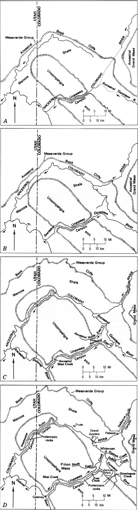
|
| PROBABLE DRAINAGE PATTERNS AND LAND FORMS NEAR THE MONUMENT AT FOUR SUCCESSIVE STAGES OF DEVELOPMENT. Solid drainage lines taken from the Moab and Grand Junction, Utah-Colorado, topographic maps of the Army Map Service; dashed drainage lines are my own ideas. A, just prior to piracy of ancestral Colorado River; B, after piracy of ancestral Colorado River and just prior to piracy of ancestral Gunnison River; C, abandonment of Unaweep Canyon, after renewed uplift of Uncompahgre arch and piracy of ancestral Gunnison River; and D, present drainage pattern after additional uplift and piracy of East Creek. Modified from Lohman (1961, 1965a, 1965b). (Fig. 34) |
Then occurred an act of piracy that put to shame the mightiest exploits of Blackbeard and Captain Kidd. In latest Pliocene or earliest Pleistocene time additional uplift of the Uncompahgre arch, an unusually large flood, or both, caused the ancestral Colorado River to overflow its banks and spill across a low shale divide into the headwaters of the tributary. Some ponding may have preceded the spillover. With this enormously increased supply of water, the tributary cut down rapidly through the soft shale and captured the entire flow of the Colorado River, but the ancestral Gunnison River still flowed through Unaweep Canyon, as shown in figure 34B. Stream capture of this type is appropriately called "piracy."
But the piracy had not ended. Note in figure 34B that the "new" river sent out several tributaries, one of which headed for and, with the aid of yet additional and greater uplift, soon captured the ancestral Gunnison River, as shown in figure 34C. This second act of piracy left Unaweep Canyon really "high and dry" except for small streams that carried off what little water the canyon received from local rain and snow. While these piracies were taking place, the Book Cliffs and the edge of Grand Mesa gradually retreated away from the valley because of erosion, and more of the Uncompahgre arch was uncovered.
The rising Uncompahgre arch, whose renewed uplifts in latest Pliocene or earliest Pleistocene times played such an important role in the ultimate abandonment of ancestral Unaweep Canyon, was asymmetric in that the crest was not in the middle but was near the southwest side. Although sharp, locally faulted monoclines are found on both sides of the arch, including the part within the Monument, in general, the northeastern flank has a rather gentle northeastward dip; whereas, the southwestern flank of the arch also is bordered by normal faults of considerable vertical displacement.26 Thus, after abandonment, the minor drainage in Unaweep Canyon continued to flow northeastward from a new divide near the south western border, and ancestral West Creek began cutting northeastward toward the new divide. The drainage pattern depicted in figure 34C differs slightly from my earlier interpretation and results from additional fieldwork.27
26See Cater, 1970, p. 67.
27Lohman 1961, 1965a. 1965b; Hunt 1969, p. 87.
At the time of abandonment, ancestral Unaweep Canyon was a V-shaped canyon resembling Glenwood Canyon just upstream from the city of Glenwood Springs, Colorado. The reasons for its change in shape and appearance to the beautiful U-shaped canyon we find today and the profound effect the abandonment of Unaweep Canyon had on the deepening of the Grand Valley and the canyons of the Monument will be brought out in the section "Canyon Cutting."
| <<< Previous | <<< Contents >>> | Next >>> |
bul/1508/sec9.htm
Last Updated: 8-Jan-2007