
|
Geological Survey Bulletin 1508
The Geologic Story of Colorado National Monument |
THE AGE OF REPTILES
ALL THE LAYERS of sedimentary rocks preserved in the Monument above the dark Proterozoic ones were deposited by wind and water during the Mesozoic Era. This long era has been called the age of reptiles, for reptiles, including dinosaurs (meaning terrible lizards), were then the dominant land animals. The Mesozoic Era has been divided into three parts—the Triassic, Jurassic, and Cretaceous Periods. Rocks of each of these periods crop out in the Monument.
Early Landscape

BY LATE TRIASSIC TIME the Monument was part of a nearly flat plain cut on the dark Proterozoic rocks, but there were hills or low mountains to the northeast. Streams from these hills dropped mud, silt, sand, and some gravel on this plain and into many small lakes that occupied the gentle depressions. Later, these deposits hardened mainly into red siltstone and sandstone, but thin beds of gravel were cemented to form conglomerate, and thin beds of limestone formed in some of the shallow lakes by the precipitation of the mineral calcium carbonate. These rocks, which comprise the Chinle (pronounced Chin-lee) Formation, are only 80 to 100 feet thick in the Monument but are as much as 700 feet thick near Moab, Utah, southwest of the Uncompahgre Plateau, where the entire formation is present. There, the Chinle rests on still older Triassic and Paleozoic rocks—all absent in the Monument for the reasons noted previously. In some parts of the Plateau, sandstone or conglomerate beds in the lower part of the Chinle yield uranium ore, but these beds were not deposited in or near the Monument.
The red color of the Chinle and some of the overlying rocks is caused by minute amounts of iron oxide—the same pigment used in rouge and red barn paint. Various oxides of iron, some including water, produce not only brick red but also pink, salmon, brown, buff, yellow, and even green or bluish green. This does not imply that the rocks could be considered as sources of iron ore, for the merest trace of iron, generally only 1 to 3 percent, is enough to produce even the darkest shades of red.
Because it is soft, the Chinle is easily eroded into steep slopes at the foot of high sandstone cliffs in all canyons of the Monument and on top of the high bluffs that face The Redlands. It also forms the broad base of Independence Monument. Rim Rock Drive crosses the Chinle three times in the lower part of Fruita Canyon and twice in No Thoroughfare Canyon.
Fossil reptile bones, petrified wood, and freshwater shells come from the Chinle in parts of Arizona and Utah. Reptiles probably roamed the Monument in Chinle time, but their remains have not been located.
Ancient Sand Dunes
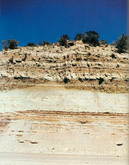
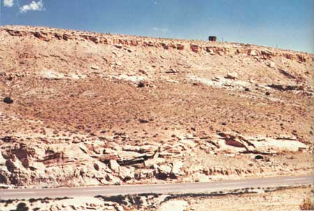
STILL LATER in the Triassic Period the Monument became part of a vast desert. Winds blowing from the northwest brought great quantities of fine sand and piled them up into large dunes like those in the Sahara or in Great Sand Dunes National Monument in Colorado. But like all deserts, it was not always dry—occasional rainstorms produced many small lakes and ponds. Some of the sand was washed into these lakes or ponds and settled in level layers. This huge sandpile eventually hardened into the buff and light-red sandstone that we now know as the Wingate. The shapes of the old dunes are indicated by the steep dips of sand layers, called crossbeds, which stand out in sharp contrast to the nearly level layers formed in the lakes and ponds (fig. 10).
|
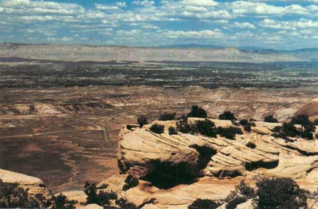
| PETRIFIED SAND DUNES in Wingate Sandstone along old Serpents Trail. Looking north across The Redlands and Grand Valley to the Book Cliffs. Battlement Mesa on right skyline. (Fig. 10) |
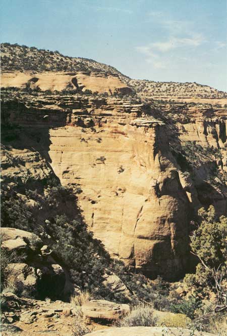
The spectacular scenery of Colorado National Monument owes its existence largely to the 350-foot cliffs of the Wingate Sandstone (fig. 6) and to the desert climate, which allows us to see virtually every foot of the vividly colored rocks and has made possible the creation and preservation of such a wide variety of fantastic sculptures. A wetter climate would have produced a far different and smoother landscape in which most of the rocks and land forms would have been hidden by vegetation.
Eroded remnants of the Wingate form most of the named rock features of the Monument and are shown in many of the photographs. Independence Monument—a towering slab of sandstone that resembles a bridge pier (fig. 6)—is all that is left of a high narrow wall that once connected the point east of Independence View with the high mesa north of the slab and which once separated the two entrances of Monument Canyon. In a few thousand years this remnant, too, may be gone.
Vertical cliffs and shafts of the Wingate Sandstone endure only where the top of the formation is capped by beds of the next younger rock unit—the Kayenta Formation. The Kayenta is much more resistant to erosion than the Wingate, so even a few feet of the Kayenta, such as the cap on top of Independence Monument, protect the rock beneath. Once this cap has been eroded away, the underlying Wingate weathers into rounded domes, such as the Coke Ovens.
Cold Shivers Point (fig. 53)—a toadstool shaped cap of sandstone of the Kayenta above a vertical cliff of the Wingate—is perhaps the most aptly titled feature of the Monument.
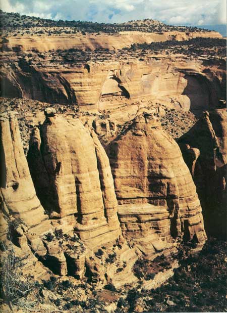
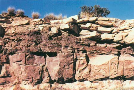
The Coke Ovens (fig. 11) and Squaw Fingers were formed partly because most of the caprock of Kayenta has been weathered away and also because the brittle rocks were cracked along an evenly spaced set of vertical joints. These joints trend northward between the two named features. More rapid weathering along these joints helped form the separate rounded domes or spires between them. Similarly, northwestward-trending vertical joints connect and helped shape Kissing Couple, Pipe Organ, and Sentinal Spire.
|
| THE COKE OVENS, looking north from overlook beneath Artists Point. A set of north-south joints has allowed erosion of the Wingate Sandstone to proceed more rapidly along these zones of weakness and has helped create the four ovens shown. Weathering away of the protective caprock of the overlying Kayenta Formation has produced rounded tops on all but the left-hand shaft, which is still protected by the Kayenta. Note alcoves and arches in cliff of the Wingate beyond, the formation of the one on the right having been aided by removal of the underlying soft Chinle Formation. Bench covered by piñon and juniper above Wingate is resistant thin-bedded Kayenta Formation. Cliff above the bench is the Slick Rock Member of the Entrada Sandstone. The Coke Ovens were named from their resemblance to the beehive-shaped brick ovens formerly used to convert bituminous coal into coke for smelting iron. (Fig. 11) |
Many of the cliff walls of the Wingate are vertical, some even overhang, yet in some places the slopes are gentle enough to hold talus and to be climbed (fig. 12). Why is this? The answer to this question is given in a later section on "Canyon Cutting."

|
| RED CANYON, looking northeast toward Grand Junction from Red Canyon Overlook. Dark notch at the bottom of the northeast end of the canyon is known as the Gunsight. Linear feature in the Grand Valley beyond is the Denver and Rio Grande Western Railroad. Prominent point near middle of Book Cliffs is Mount Garfield (Fig. 25). Battlement and Grand Mesas form left and right skylines. respectively. Dark green bush in right foreground is Mormon Tea. (Fig. 12) |
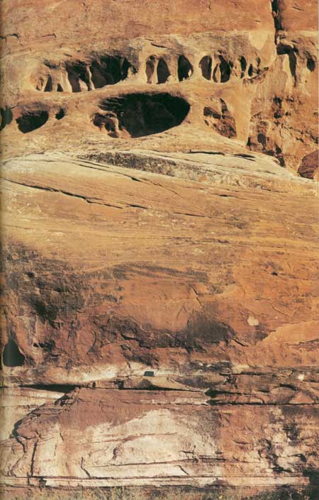
Arches or shallow caves weathered out of some cliff faces of the Wingate, particularly where the underlying Chinle Formation has been partly scoured away. Although there are no large caves within the Monument, there are three in a row along the road 3 miles west of the Glade Park Post Office. One of these was inhabited until 1958 (fig. 5).
Many of the cliff faces of the Wingate are darkened or blackened by desert varnish—a natural pigment of iron and manganese oxides, silica, and clay.15
15Potter and Rossman, 1977.
Dinosaurs left their footprints in the sands of the Wingate in parts of the Colorado Plateau, but no tracks or fossils have yet been found in this formation in or near the Monument.
The Rains Came
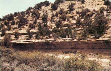
THE ARID CLIMATE of Wingate time was followed by a wet period, when streams from the northeast gradually covered the sand dunes with mud, sand, and some gravel. The sand and gravel of the stream channels were cemented into hard sandstone and conglomerate, and the mud of the flood plains hardened into red and purple siltstone and mudstone. The resulting Kayenta Formation makes up the bench between the two cliffs upon which the Visitor Center, campgrounds, and most of scenic Rim Rock Drive were built. Here, nature was kind, for this gently sloping bench was an ideal place to build the road from which to look down into the deep chasms. The Kayenta also caps the broad mesas between the canyons. It is about 350 feet thick in eastern Utah, only 45 to 80 feet thick in the Monument, and it is absent altogether not far east of the Monument. The reasons for the eastward thinning and ultimate disappearance of the Kayenta and some younger rocks are given in the next section.
As noted earlier, the sandstone beds and lenses of the Kayenta generally are coarser grained (some even contain small pebbles) and much harder than the underlying Wingate Sandstone—particularly the lower beds of the Kayenta, which serve as a protective capping, as shown in figure 13 and in many of the other photographs. Unlike the dominantly fine grained, well sorted, windblown sands of the Wingate, the coarser stream-laid sands of the Kayenta are angular and poorly sorted, so that small grains fill spaces between larger ones. Moreover, in addition to the calcite cement (which also holds together the sand grains in the Wingate and Entrada Sandstones), most of the sand grains and pebbles in the Kayenta are covered by interconnected "overgrowths" of silica (SiO2), which make up about 10 percent of the rocks and serve as a nearly insoluble hard cement.16
16According to Robert A. Cadigan, U.S. Geological Survey.
|
| THIN BEDDED KAYENTA FORMATION protecting underlying cliff of softer Wingate Sandstone. Rim Rock Drive is on bench of the Kayenta close to thinner cliff of Entrada Sandstone in background. Looking northwest from a point north east of Monument Canyon View. (Fig. 13) |
The combination of the coarse and fine grains and interlocking silica "overgrowths" makes the Kayenta one of the most resistant rocks in the Colorado Plateau.
In distant views of weathered outcrops the Kayenta appears to consist mainly of thin beds or lenses of sandstone, which indeed it does, but in some fresh exposures, such as roadcuts, the highly lenticular red flood-plain deposits form striking features which may wedge out from 3 or 4 feet thick to a featheredge within horizontal distances of only a few feet (fig. 14).
|
| KAYENTA FORMATION, showing lenses of hard channel sandstones and wedge of red siltstone and mudstone. Along road cut of Rim Rock Drive near head of main stem of Ute Canyon. Vertical grooves remain from drill holes used in blasting roadcut. (Fig. 14) |
The Kayenta has yielded fossil bones of dinosaurs and other reptiles in northeastern Arizona and freshwater shells in eastern Utah. As yet, however, no fossils have been reported from it in or near the Monument.
Another Gap in the Rock Record

FOLLOWING THE WET INTERVAL when the Kayenta Formation was deposited over wide areas of the Colorado Plateau by streams, the Plateau once again became a vast desert, and this time the dry climate persisted from the Late Triassic into the Jurassic. The howling winds piled up enormous sand dunes, layer upon layer, to a total thickness of more than 2,200 feet at Zion National Park, and as much as 500 feet remains in eastern Utah and parts of southwestern Colorado. This immense sandpile eventually was cemented by calcite into the Navajo Sandstone.
Beautifully sculptured remains of the Navajo are featured attractions at Zion, Capitol Reef, and Arches National Parks, Rainbow Bridge, Navajo, and Dinosaur National Monuments; border many miles of beautiful Lake Powell; and form the eastern flank of the San Rafael Swell. For reasons to be explained, this sandstone thins to the northeast, and is absent entirely at about the Utah-Colorado State line, some 35 miles southwest of the Monument. Thus, in the Monument, the Navajo, most of the Kayenta, and the lower part of the Entrada Sandstone are missing at another gap in the rock record, as shown in figure 15.
|
| GAP IN THE ROCK RECORD, between Kayenta Formation below 3-1/2- x 6-inch green notebook and Slick Rock Member of Entrada Sandstone above. The reasons for this gap are given in the text on page 38. That this is an erosional unconformity is clearly indicated by the uneven top of the Kayenta, particularly to the left of the notebook. Note solution pits and openings in the Entrada near top of photograph. (Fig. 15) |
How is it possible that the Navajo Sandstone is more than 2,200 feet thick in Zion National Park, is several hundred feet thick in much of the Plateau in Utah and parts of southwestern Colorado, yet is absent entirely, together with a considerable thickness of younger rocks in and near Colorado National Monument? How much of the missing strata once were present in the Monument is not known, but it seems clear that at least part was present but was eroded away before the Entrada Sandstone was deposited. There is evidence17 that following the deposition and consolidation of the Navajo Sandstone the Plateau and adjacent areas were uplifted, tilted gently westward, and eroded for a considerable period of time. Erosion naturally was most pronounced in the eastern areas, including the Monument, where the uplift was greatest. Thus, in the northeastern part of the Plateau all the Navajo and most of the Kayenta were eroded away, and erosion continued there while the lowest member of the Entrada, the Dewey Bridge Member, and the lower part of the overlying Slick Rock Member were being laid down in the Moab, Utah, area.18 This old erosion surface is clearly visible in many places along the cliff wall on the southwest side of Rim Rock Drive between the Visitor Center and Kissing Couple.
17See Pipiringos and O'Sullivan, 1975.
18See Wright, Shawe, and Lohman, 1962.
The reduction in thickness of the Navajo Sandstone from southwest to northeast and absence of the Navajo and some younger rocks in and near the Monument are shown on an isometric (three dimensional) block diagram prepared by artist John R. Stacy and me, which is displayed in the Museum of the Visitor Center. This block diagram portrays the surface and subsurface rocks from Zion National Park, Utah, to Black Canyon of the Gunnison National Monument, Colo., via Capitol Reef National Park, the Henry Mountains, and Colorado National Monument. Throughout the Plateau and parts of adjacent areas, the erosion surface on top of the Navajo Sandstone is covered by scattered pebbles of chert—a hard variety of silica (SiO2) derived from cherty beds of freshwater limestone in the Navajo.19 Where the Navajo has been completely eroded away and the ancient erosion surface is on the Kayenta Formation, as in Colorado National Monument, scattered pebbles (some of which are chert) derived from the conglomerate lenses in the Kayenta are found locally on the old surface.20
19Pipiringos and O'Sullivan, 1975.
20According to Fred Peterson, U.S. Geological Survey.
Because of this gap in the rock record we will continue part of our story farther west, where the rock record is more nearly complete.
The Sea to the West

IN MIDDLE JURASSIC TIME the land now called central Utah, which then was the eroded surface of the Navajo Sandstone, sank beneath an arm of a shallow sea that came in from the north, and most of the area remained beneath this sea until Late Jurassic time. Sediment carried into this sea and into bordering lagoons and estuaries later hardened into the sedimentary rocks of the Carmel Formation, Entrada Sandstone, and Curtis and Summerville Formations. The Carmel and Curtis contain abundant marine fossils of Middle Jurassic age, and in central Utah the intervening unfossiliferous Entrada also is believed to have been deposited in or near the sea, and the unfossiliferous Summerville Formation probably was deposited upon a tidal flat that was submerged part of the time.
Deposits and Events East of the Sea

IN EASTERN UTAH, east of the ancient Jurassic sea, the Entrada Sandstone is entirely unfossiliferous, was partly water laid and partly wind blown, and has been divided into three distinctive parts, which in ascending order are the Dewey Bridge, Slick Rock, and Moab Members.21 In and near the Colorado National Monument, the long period of erosion discussed in a preceding section probably continued well into the Jurassic, so only the upper part of the Slick Rock Member and the overlying Moab Member were deposited on the eroded surface of what little remained of the Kayenta Formation (fig. 14).
21Wright, Shawe, and Lohman, 1962; Lohman, 1975.
The Slick Rock Member was named from its occurrence at and near the mining town of Slick Rock, Colo., which originally was named after the appearance of the rock because it generally forms slick, smooth cliffs. It reminds one of the chicken and egg conundrum. The Slick Rock is composed mainly of sand dunes that were piled up on the eastern shore of the Jurassic sea by winds blowing from the northeast. Occasional rainy spells created lakes and ponds in which some of the sand was laid down in level beds. This pile of sand later hardened into the cliff-forming Slick Rock Member, which looks something like the Wingate but is generally only half as thick, weathers into less abrupt cliffs, is mostly salmon red, and is almost free of joints. The joints in the Wingate (fig. 11) probably resulted from the uplift and tilting of the Plateau before the long period of pre-Entrada erosion; whereas the land seems to have been more stable during Entrada time. The Slick Rock is cemented with calcium carbonate (CaCO3), which is soluble even in weak acid, such as rain or snow water containing dissolved carbon dioxide. For this reason solution openings or pits occur in some of the cliff faces, the most striking of which are those shown near the top of figure 15.
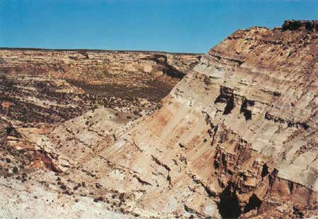
The Slick Rock Member of the Entrada Sandstone forms a line of cliffs and isolated monoliths that are second in height and grandeur only to those of the Wingate. The Member is best displayed southwest of Rim Rock Drive between the Visitor Center and the Coke Ovens and along the western arm of Ute Canyon (fig. 16). It also forms the Saddlehorn just south of the camp and picnic grounds near the Visitor Center (fig. 50). Most of the smooth cliff faces show both the steeply dipping crossbeds of the old sand dunes and the flat-lying beds of the lake or pond deposits.
|
| ENTRADA SANDSTONE, just above normally dry waterfall in west arm of Ute Canyon. Note smooth unjointed cliff of Slick Rock Member protected at left by overhanging basal bed of Moab Member, which forms about lower half of slope in distance. Upper part of distant slope is the Summerville Formation overlain by Salt Wash Member of the Morrison Formation. Note Slick Rock at left resting upon eroded crossbedded sandstone in Kayenta Formation, in which the canyon was cut. (Fig. 16) |
The overlying Moab Member of the Entrada is a white level-bedded sandstone that generally weathers into stairsteps or ledges. One of the best exposures of the Moab Member is shown in figure 17, but good exposures also are seen along the west side of Rim Rock Drive just northeast of the Coke Ovens Overlook. In some places the Moab Member forms cliffs continuous with those of the underlying Slick Rock Member. It appears to consist of hardened beach or lagoon sand that was deposited along the eastern shore of the sea, which suggests that the sea extended farther east during Moab and Summerville times than it did during Dewey Bridge and Slick Rock times. Like the Slick Rock, the Moab also is cemented by calcium carbonate, but the lower sandstone ledges of the Moab Member are more resistant to erosion than the Slick Rock Member, so the Moab helps preserve the underlying cliffs. The top of the Moab Member forms patches of bare pavement east of the Monument, known as the "Slick Rim," which may be observed from the Little Park Road.
|
| MOAB MEMBER OF ENTRADA SANDSTONE, showing typical steplike weathering. In west arm of Ute Canyon about a quarter mile above the view shown in figure 16. Moab Member caps and protects overhang of Slick Rock Member. Moab is overlain by unexposed slope of Summerville Formation and lower part of Morrison Formation. (Fig. 17) |
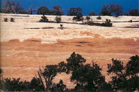
Although the Slick Rock Member normally is salmon colored or pink, the upper half of an outcrop just north of the highest point on Rim Rock Drive at the head of main Ute Canyon has a distinctly mottled appearance, wherein much of the color has been leached to white, but irregular splotches of color appear in the dominantly white upper part, and white splotches appear in the colored part, as shown in figure 18. By way of contrast, in an outcrop of the two members of the Entrada about 2 miles north of the Glade Park Store and Post Office (fig. 19), the entire Slick Rock Member is as white as the Moab Member, and the former is white for some distance to the east. Why is the salmon color entirely missing from the Slick Rock near Glade Park, partly missing in figure 18, but present virtually everywhere else in and near the Monument? The answers to this seeming mystery involve events that occurred long ago, so only the high points will be touched upon here.
|
| MOTTLED SALMON-AND-WHITE SLICK ROCK MEMBER, overlain by white level-bedded Moab Member, on west side of Rim Rock Drive about four-tenths of a mile north of head of main Ute Canyon. (Fig. 18) |
|
| WHITE ENTRADA. SANDSTONE, in outcrop just east of gravel road about 2 miles north of Glade Park Store and Post Office. Reasons for absence of salmon color in Slick Rock Member are given in text. (Fig. 19) |
It seems reasonable to suppose that the Slick Rock Member at both localities originally was salmon colored or pink, as it is everywhere else, but that later, the coloring agent, red ferric iron oxide (Fe2O3), was chemically reduced, or leached to ferrous iron oxide (FeO), by acidic ground water, and was carried away to the northeast by the slowly moving ground water. But as I have already pointed out, the cliff exposures of the sandstones are now bone dry, so what happened to the ground water and why was it acidic here and not elsewhere?
Before the cutting of the deep canyons of the Monument, which followed the last major uplifts of the region accompanied by bending and breaking of the rocks, the now dry sandstones were saturated with ground water that moved very slowly northeastward. Somewhere to the southwest the Entrada Sandstone seemingly took in water containing dissolved hydrogen sulfide gas (H2S), changing the ground water to a weak acid. The H2S could have been produced by a type of anaerobic bacteria that has the ability to reduce dissolved sulfates (SO4-2) in water to the dissolved hydrogen sulfide gas, thereby obtaining needed oxygen.
The next questions you might logically ask are (1) if the above deductions have any merit, how do we know the acid water was caused by dissolved hydrogen sulfide,22 (2) what is the source of the sulfate ions (SO4-2) from which the H2S was obtained, and (3) why is the color of the Slick Rock Member in figure 19 completely reduced to white whereas that in figure 18 is only partly reduced in the upper part?
22Paul L. Williams, U.S. Geological Survey, told me in November 1978 that he observed H2S-bearing spring water leaching the color from both the Entrada and Wingate Sandstones above Tabeguache Creek some 8 or 10 miles north of Nucla, Colo., and from the Wingate alone along Onion Creek in eastern Utah.
Although the ground waters from artesian wells in the Grand Junction area contain small amounts of sulfate as do most ground waters, the amount needed for the results observed more likely came from solution of the common mineral gypsum (calcium sulfate containing some water, CaSO4°ree;2H2O). The overlying Summerville and Morrison Formations contain some gypsum in many places in Utah, so it is not improbable that these formations contain gypsum locally in Colorado. If so, sulfate-bearing water could have percolated downward into the Entrada at some point southwest of Glade Park. But as this must have happened several million years ago, the clues as to just where this occurred have grown quite cold.
Seemingly, the color in the Slick Rock Member near and east of Glade Park was entirely removed by the process described, but the very slow moving ground water had time to leach only the upper part of the Slick Rock (the most permeable part) in Ute Canyon before the process was halted forever by the draining of water from these beds by canyon cutting.
Shortly before the Jurassic sea to the west dried up, silt, mud, and some sand were carried into either a shallow arm of the sea or a broad bay or lagoon near it, and later the silt, mud, and sand hardened to become the Summerville Formation. The Summerville is only 40 to 60 feet thick in the Monument but is much thicker in Utah.
The Summerville Formation is so soft that it weathers very rapidly and hence is exposed at only a few places. It is best displayed in the high roadcut at Artists Point and along the road to the south for the next mile (fig. 20), but it is also exposed in roadcuts along the west arm of Ute Canyon. Even the thinnest beds of the Summerville can be traced for hundreds of yards, and individual beds have a nearly constant thickness for such distances. This greatly facilitated the detailed measurement of a section of the Summerville23 by my son Bill and me from Artists Point to the base of the overlying Morrison Formation about a mile south. Using a 6-foot folding steel rule we measured and described each thin bed from some key bed at about ground level to one at eye level, followed the upper key bed southward to ground level, then repeated the process until the entire 54 feet had been measured and described.
23Lohman, 1965a. p. 47, 48.
|
| SUMMERVILLE FORMATION, at Artists Point (fig. 3). Base of formation rests upon Moab Member of Entrada just beneath the pavement. Note geologist's pick resting upon lower ledge of sandstone just to the left of middle. Top of the Summerville here has been removed by erosion. (Fig. 20) |
The Summerville at the type locality in the San Rafael Swell, Utah, is much thicker than in the Monument and contains many chocolate-brown beds; but the Summerville exhibits the same lateral continuity of even the thinnest beds. Thin sedimentary beds of such uniform thickness are thought to have accumulated in relatively quiet bodies of water. If you look at the undersides of some of the blocks of hard light-gray sandstone that have broken off, you may see corrugations like those on some metal barn roofs. These are ripplemarks produced by wave or current action while the sand was still loose, which indicates that the water was not always entirely quiet. Although much of the Summerville is red, you will see beds of many other colors including gray, blue gray, greenish gray, chocolate brown, and reddish brown.
Dinosaurs Roam the Monument

IN LATE JURASSIC TIME the sea to the west eventually dried up, either because it was filled with sediments or because the land rose above sea level, or both. This brought about a change from the parallel bedding in the marginal marine environment of the Summerville to irregular stream-channel sandstones, flood-plain silts and muds, and freshwater lake deposits.
Streams from higher lands to the south brought in mud, silt, and sand that piled up hundreds of feet thick over thousands of square miles, including the Monument. These sediments were later compacted into the brightly colored siltstone, mudstone, sandstone, and limestone now known as the Morrison Formation. The colors are about the same as those of the Summerville. Algae and other microscopic organisms extracted calcium carbonate from the lake waters, and when they died this material settled on the lake bottoms to make limestone.
The soft siltstone and mudstone of the Morrison Formation weather rapidly into steep or fairly steep slopes, but the harder beds of sandstone, most of which are in the lower third of the formation, known as the Salt Wash Member, are sculptured into bold ledges or low cliffs. The generally softer upper two-thirds of the formation is called the Brushy Basin Member. The Morrison is best exposed in and southeast of The Redlands, where the bare rocks are carved into badlands like the famous ones of South Dakota. Both the Fruita Canyon and No Thoroughfare Canyon approaches to the Monument pass typical badlands in the Morrison. The entire 600 feet of this formation is best seen in the high bluff on the east side of the mouth of No Thoroughfare Canyon (fig. 21).
|
| MORRISON FORMATION, on east side of mouth of No Thoroughfare Canyon. Forty feet of Summerville Formation at base is concealed by slope wash, but underlying white- and salmon-colored members of Entrada Sandstone are clearly exposed at lower left. Protective caprock at upper right is lowermost sandstone of Cretaceous Burro Canyon Formation. Upper two-thirds of Morrison is typical of the Brushy Basin Member; lower one-third is not typical of the Salt Wash Member, which generally contains more and thicker lenses of sandstone, some of which are just around the corner to the right. Mesa on left skyline is above Serpents Trail in the Monument. Looking west from Little Park Road. See also figures 55 and 60. (Fig. 21) |
In parts of the Colorado Plateau southwest of the Uncompahgre Plateau, the sandstone lenses in the Salt Wash Member of the Morrison contain uranium and vanadium ore associated with carbonaceous matter, including coalified wood. No ores have been found in or near the Monument presumably because such carbonaceous matter, which helped precipitate the ores, is lacking on the northeastern side of the Uncompahgre Plateau.
Some of the beds of siltstone and mudstone in the Brushy Basin Member of the Morrison shown in figure 21 contain bentonite, a clay derived from the decomposition of volcanic ash, which indicates the presence of active volcanos in or near the Plateau at the time these beds were deposited. Bentonite swells when wetted, so it is widely used in well-drilling muds, sealing canals, etc. Some bentonitic material has been dug from the Brushy Basin along the Little Park Road just south of the point from which the photograph in figure 21 was taken and was used for sealing irrigation canals in the Grand Valley.
The Morrison is not well exposed in the Monument, as the formation is restricted to the higher parts where most of it is hidden by vegetation. The lower part is seen in roadcuts and outcropping ledges along a high stretch of Rim Rock Drive between Artists Point and the head of the west arm of Ute Canyon, where sandstone lenses in the Salt Wash Member are especially thick.
The climate during Morrison time was wet enough to support abundant vegetation along the many lakes and streams—at least enough to feed the hungry dinosaurs and other reptiles that roamed the area. Many bones and parts of several skeletons of dinosaurs have been found in the Morrison at several places in The Redlands not far northeast and north west of the Monument.
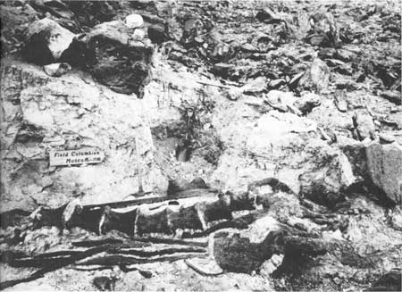
The most famous dinosaur locality near the Monument is Riggs Hill where, in 1900, the late Elmer S. Riggs of the Field Columbian Museum (now Field Museum of Natural History) dug out part of the first known skeleton of a huge Brachiosaurus (fig. 22). This discovery made quite a splash in the scientific world, for it was the first and only type of dinosaur found whose front legs were longer than its hind legs. The fossilized thigh bone (femur) alone is 6 feet 8 inches long and weighs 549 pounds; the arm bone (humerus), though incomplete, is even longer. The ribs are 9 feet long. A bronze plaque now marks the site of the excavation (fig. 39).
|
| EXCAVATING TYPE SPECIMEN OF BRACHIOSAURUS ALTITHORAX RIGGS from south side of Riggs Hill. Photograph taken in 1900, reproduced by permission of the Field Museum of Natural History (Chicago). See also figure 39. (Fig. 22) |
In 1901, Riggs removed all but the forepart of a skeleton of Apatosaurus from the southeast side of a large hill of the Morrison Formation just south of the old Fruita bridge. Riggs also found remains of Diplodocus, Camarasaurus, and Morosaurus, and, in 1937, Al Look, prominent writer and amateur paleontologist of Grand Junction, and Edwin L. Holt, an instructor in Mesa College at Grand Junction, found the closely associated remains of Allosaurus, Stegosaurus, and Brachiosaurus at the western end of Riggs Hill. Dinosaurs generally are thought of as huge creatures—many were huge indeed (fig. 23)—but they came in various sizes and some were quite small.

|
|
SKELETONS OF TYPICAL DINOSAURS OF MORRISON FORMATION.†
A, Camptosauris, a small dinosaur about 11 feet long; B,
Apatosaurus, a gigantic dinosaur about 76 feet long; C, Allosaurus, a large
carnivorous dinosaur about 30 feet long; and D, Stegosaurus, a large armored
dinosaur about 24 feet long. (Fig. 23) †A, modified from Gilmore, courtesy U.S. National Museum, B, modified from Gilmore, courtesy Carnegie Museum; C, modified from Mathew, courtesy American Museum of Natural History; and D, modified from Romer, after Marsh and Gilmore, courtesy University of Chicago Press. |
An interesting Late Jurassic vertebrate fossil locality in the Salt Wash Member of the Morrison Formation, about 3 miles northwest of the West Entrance of the Monument and about 3 miles southwest of Fruita, was discovered in June 1975 by George Callison, Associate Professor of Biology and Research Associate in Vertebrate Paleontology at the California State University at Long Beach. During the summers of 1975 and 1976 Dr. Callison and his assistants removed the closely associated skeletal remains of many small, primitive mammals and both small and large dinosaurs and other reptiles. Part of the results were presented in an unpublished manuscript.24 During the summer of 1977 and later, additional mammalian fossils were removed by Callison and assistants and additional reptilian fossils were removed by Lance Erickson, paleontologist from south side of Riggs Hill. Photograph taken in 1900, reproduced by permission of the Field Museum of Natural History (Chicago). See also figure 39. (Fig. 22) of the Historical Museum and Institute of Western Colorado (fig. 2). Hopefully, the work will be continued with the aid of grants from several sources.
24Study of a fauna of small vertebrates from the late Jurassic Morrison Formation of western Colorado, by George C. Callison, 21 pages, June 1978.
The locality, which covers parts of about 180 acres of public land administered by the Bureau of Land Management, has been fenced and posted to discourage vandalism, and has been designated the Fruita Paleontological Area.
In order to evaluate the importance of the locality and to make plans for its future development and protection, the Bureau of Land Management held the Fruita Paleontological Workshop on March 28-30, 1977, to which were invited several renowned vertebrate paleontologists and archaeologists together with interested local personnel of the Bureau, the National Park Service, and the Museum. All remarks and prepared speeches were taken down by a shorthand reporter and were reproduced for the attendees in the 83 page unpublished "The Fruita Paleontological Report."
The close association of Late Jurassic mammalian and reptilian fossils, as found at the Fruita site, is of considerable interest and importance, but is by no means unique, for similar associations occur elsewhere in Colorado, and in Wyoming, Europe, and Africa. Of those in the United States, the quarry at Como Bluff, near Laramie, Wyo., is considered by most of the experts to be the most outstanding. Of the material unearthed at Fruita thus far, which includes bones of some of the large dinosaurs found earlier by Riggs, remains of some of the smaller dinosaurs and a complete skull of the moderately large flesh eater Ceratosaurus are considered the most important.
Freshwater clam and snail shells abound in some beds of the Morrison, particularly in limestones, and occur sparingly in other types of beds. The shells occur mainly in The Redlands, particularly about 1-1/2 miles west of the Fruita bridge. Some of these shells that are filled with agate are sought by rockhounds.
Dinosaurs on the Move
THE WET CLIMATE of Late Jurassic time was followed by arid or semiarid climate in the Early Cretaceous. Streams continued to deposit gravel, sand, silt, and mud, but at a much slower rate. These deposits eventually hardened into the conglomerate, sandstone, and green shale or siltstone of the Burro Canyon Formation. This formation, together with part of the overlying Dakota Sandstone, caps Black Ridge, the highest part of the Monument (7,000 feet) about a mile west of the Coke Ovens. Several airway beacons on this high ridge may be seen for many miles. The Burro Canyon is best seen below the Monument on the west side of Monument Road along the lower part of No Thoroughfare Canyon, where it is about 60 feet thick (fig. 24).
|
| BURRO CANYON FORMATION AND DAKOTA SANDSTONE. along west side of No Thoroughfare Canyon. about 2-1/2 miles northeast of the Monument's East Entrance. Basal sandstone above road and unexposed green shale (brown in photograph) comprise the Burro Canyon, here 58 feet thick. White band two-thirds the way up the slope is 40-foot basal conglomerate of the Dakota Sandstone, above which is 58 feet of carbonaceous shale, a 14-foot bed of sandstone, and 17 feet of sandy shale to the top of the hill. The top of the Dakota has been eroded way. (Fig. 24) |
A few fossil plants and shells have come from the Burro Canyon Formation, but the seeming absence of dinosaur bones suggests that possibly these reptiles had to move to areas of greater precipitation, where food was more abundant. Some dinosaurs may have lived in the area at this time, but their bones either were not fossilized or they have not yet been found.
Yet Another Gap in the Rock Record

DEPOSITION of the Burro Canyon Formation was brought to a close by another uplift of the Plateau, and of course the uplift was followed by another period of erosion, which continued through the end of Early Cretaceous time. As noted in the caption for figure 24, seemingly all but 58 feet of the Burro Canyon was eroded away, but 120 feet remains along East Creek, only about 12 miles to the southeast, which suggests that the old erosion surface was a bit uneven. That this period of erosion was of considerable duration is suggested by the abundance of the white clay mineral, kaoliite, beneath and in the overlying white basal conglomerate of the Dakota Sandstone. This type of clay commonly results from prolonged weathering of many types of rocks and indicates that the period of pre-Dakota erosion was of long duration.
Peat Bogs
BY THE BEGINNING of Late Cretaceous time the eroded surface of the Monument was part of a low plain near sea level, and the sea was gradually encroaching from the east or northeast. Gravel and sand carried in by streams combined with the white kaolinite on the surface to form the 40-foot basal conglomerate of the Dakota Sandstone fig. 24).
As the land gradually subsided nearer to sea level, swamps which were formed along the coast supported considerable vegetation. As the trees and plants died and were covered by silt and mud, they gradually changed to peat which finally became compacted into coal and brown or black coaly shale containing plant remains. You can dig out some of this coal and perhaps find some plant remains near the top of the west canyon wall just below the highest sandstone bed in figure 24, which is outside the Monument.
For awhile the coast alternately sank slightly below and rose slightly above sea level. Beach sand covered the swamp deposits, then more swamp deposits covered the sand. Some of the sand contains seashells, such as oysters and clams.
Except on Black Ridge, the Dakota has been entirely eroded from the Monument, but it crops out with the underlying Burro Canyon in a series of low hills south of the Colorado River. The Dakota Sandstone is about 200 feet thick.
The Sea Covers the Plateau

STILL LATER in the Cretaceous Period the whole region sank beneath the sea and stayed there a long time. Silt and limy mud were piled layer upon layer on the sea floor and hardened into the gray and black Mancos Shale. Thin layers of sand were cemented into sandstone, and layers of calcium-carbonate mud became chalk or limestone. Seashells and bones of sharks and seagoing reptiles have been found in the Mancos in many places.
The Mancos and all younger rocks have been stripped off the Monument, but they may be seen one after the other as you travel northeastward. Thin remnants of the Mancos cap low hills just south of the Colorado River, and the entire 3,800 feet of the Mancos underlies the Grand Valley and Book Cliffs. The upper part is clearly exposed in the towering, barren Book Cliffs, where the soft shale is protected by a caprock of hard sandstone—the lowermost unit of the overlying Late Cretaceous Mesaverde Group (fig. 25).

|
| MOUNT GARFIELD, a prominent point on the Book Cliffs bordering the north eastern side of the Grand Valley. Slopes are Mancos Shale; ledge about halfway upslope is the toe of an ancient landslide deposit of Mesaverde sandstone blocks marking the level of an ancestral Grand Valley; capping beds of sandstone at crest are basal beds of Mesaverde Group. (Fig. 25) |
The Sea's Final Retreat

SLOW UPLIFT of the Plateau, including the Monument region, caused the gradual retreat of the Mancos sea. Deposition of mud on the sea bottom gave way to deposition of beach sand, coal swamps, and then more beach sand and coal swamps. Finally, in Late Cretaceous time, the sea withdrew entirely, never again to return to the Colorado Plateau region.
Streams deposited sand, silt, and mud on the newly uplifted coastal areas. All these deposits, including some high-grade bituminous coal that was formed in the swamps, we now know as the Mesaverde Group. The thick cliff-forming sandstones of this unit are beautifully displayed in DeBeque Canyon of the Colorado River between Palisade and DeBeque, just upstream from the Grand Valley. There are several active coal mines in the Mesaverde between Palisade and Cameo, and outcrops of coal may be seen on the east side of the road just south of Cameo. The electric generating station of the Public Service Company of Colorado at Cameo is conveniently situated over a coal mine and next to the Colorado River, which supplies cooling water.
The remains of dinosaurs have been discovered in rocks of this age elsewhere, but near the Monument only their tracks have been found. Some of these, in coal mines along the Book Cliffs and near Cedaredge, are 38 inches across and their placement indicates an incredible stride of 16-1/4 feet! Had there been highways in Mesaverde time, this bipedal giant could have crossed them in two strides.
Both the Mancos and Mesaverde once covered the Monument area but were removed long ago by erosion.
End of the Dinosaurs
THE END of the Cretaceous Period was also the end of the dinosaurs. Exactly why the "terrible lizards" died out after dominating the world for more than 150 million years is not known for sure, but many guesses have been made.
One likely idea is that widespread uplift and mountain building that began late in Cretaceous time, accompanied by changes in climate, may have greatly reduced the supply of soft edible plants. If so, it is easy to imagine how huge dinosaurs accustomed to a ton or more of lush plant food each day would soon starve to death.
Many dinosaurs were vegetarians. As they died out, the flesheaters, such as Tyrannosaurus, soon ran short of food also, and probably began to eat each other. Tyrannosaurus closely resembled the Jurassic Allosaurus shown in figure 23, except that Tyrannosaurus was much larger and more formidable—in fact it probably was the most terrible predator that ever roamed the surface of the Earth. The dinosaurs had become too highly specialized to their environment to adapt themselves to changes of this kind.
Another fascinating notion is that the growing population of small primitive mammals devoured dinosaur eggs (which were left unattended like those of turtles and alligators) nearly as fast as mamma dinosaur could lay them. But whatever the reason, it is clear that some worldwide condition caused the gradual extinction of the ponderous over-specialized dinosaurs and allowed the rise to power of the next types of animals destined to rule the Earth—the brainier and more adaptable mammals.
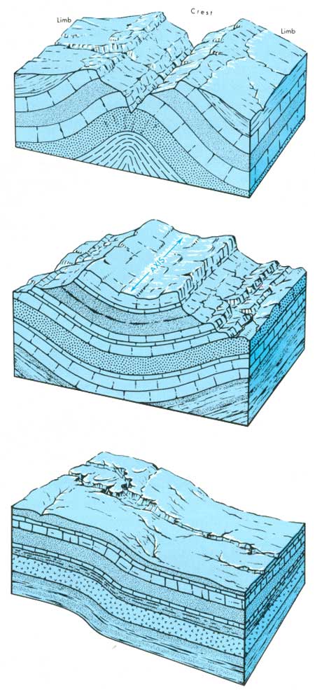
At this time the rocks were gently bent into upfolds, called anticlines or arches, and downfolds, called synclines or basins (fig. 27). One upfold that began to take form was the Uncompahgre arch, the crest of which shapes Piñon Mesa just south of the Monument. But this gentle upfold was to grow larger and to have its flanks wrinkled and broken in the next geologic era—the Cenozoic.
|
| COMMON TYPES OF ROCK FOLDS. Top, anticline or upfold; closed anticlines are called domes. Middle, syncline or downfold; closed synclines are called structural basins. Bottom, monocline a common type on the Plateau in which the dip of the beds changes in amount but not in direction; axes may be mapped along trends of upper fold, middle flexure, or lower fold. Top and middle diagrams from Hansen (1969, p.31, 108). (Fig. 27) |
| <<< Previous | <<< Contents >>> | Next >>> |
bul/1508/sec8.htm
Last Updated: 8-Jan-2007