|
Geological Survey Bulletin 1508
The Geologic Story of Colorado National Monument |
THE GEOLOGIC STORY BEGINS
COLORADO NATIONAL MONUMENT is a land of brightly colored cliff-walled canyons and towering monoliths—a majestic sample of mysterious canyonlands that stretch hundreds of miles to the west and south. Now a desert region more than a mile above the sea, it was not always so. More than a billion years ago the site of the Monument was deep beneath the sea. Later, lofty mountains were pushed up only to be obliterated eventually by the slow but relentless forces of erosion. Millions of years later the earth shook to the stride of 10-ton dinosaurs—then the sea returned again and sharks swam over the region looking for food.
These are but a few samples of the interesting—even exciting—events in the long geologic history of the Monument. Many pages, indeed several whole chapters, of its history are missing and must be inferred from nearby regions where the story is more complete. Thus, the cliffs and canyons you are looking at did not get that way overnight. An understanding of the geologic processes and events that led to the scenic features of today should help you toward a clearer picture and greater appreciation of nature's handiworks (fig. 6).

|
| INDEPENDENCE MONUMENT, separating the two entrances of Monument Canyon. Looking north from Grand View; Colorado River, Grand Valley, and Book Cliffs in distance. Roan Cliffs are white cliffs at extreme distance on right skyline. Dark rock flooring canyon is Proterozoic metamorphic rock, red material in slope at base of cliffs is the Chinle Formation, vertical cliffs are Wingate Sandstone, thin protective caprock on top of cliffs is lower sandstone of the resistant Kayenta Formation. The top of Independence Monument is nearly 450 feet above the floor of the canyon. (Fig. 6) |
Geologists recognize rocks of three distinctly different modes of origin—sedimentary, igneous, and metamorphic, and there are many variations of each type. The sedimentary rocks of the Monument are composed of clay, silt, sand, and gravel carried and deposited by moving water; silt and fine sand transported by wind; and some limestone, composed mainly of the mineral calcium carbonate, which was precipitated from water solutions in freshwater lakes. In areas not far to the northeast and southwest are many sedimentary rocks of marine origin, that is, materials that were deposited in the ocean or shallow inland seas, but in the Monument marine sedimentary rocks occur only in parts of the Dakota Sandstone; however, the overlying marine Mancos Shale underlies the adjacent Grand Valley and forms the lower slopes of the Book Cliffs across the valley (fig. 25).
Igneous rocks were solidified from liquid molten rock intruded upward into any preexisting rocks along cracks, joints, and faults. Molten rock that reaches the land surface and forms volcanos or lava flows is called extrusive igneous rock. Joints are cracks or breaks in rocks along which no movement has taken place. Faults are cracks or joints along which one side has moved relative to the other. Different types of faults are shown in figure 28. Metamorphic rocks were formed from either of the other types by great heat and pressure at extreme depths in the Earth's crust. Metamorphic rocks and some intrusive igneous rocks make up the hard, dark rock that floors all the deep canyons in and near the Monument. The nearest extrusive igneous rocks are the thick, dark lava flows that cap towering Grand Mesa to the east and Battlement Mesa to the northeast.
After the materials of the sedimentary rocks were deposited and covered by younger layers, they generally became saturated or partly saturated with ground water containing small amounts of dissolved minerals. Some of these minerals precipitated from solution and cemented the loose particles into rocks of varying hardness. Thus, most of the sandstones are partly cemented with the mineral calcite, composed of calcium carbonate (CaCO3), but some are cemented also with silica (SiO2) or hematite (Fe2O3).
Look almost anywhere in the Monument and you will see that the rocks are piled up in layers of different color, thickness, and hardness—much like a vast layer cake. In most of the Monument, these layers are flat or slope gently down to the northeast, but along the northeastern boundary they are sharply bent or broken as though the cake had been carelessly placed over the edge of a table and had sagged.
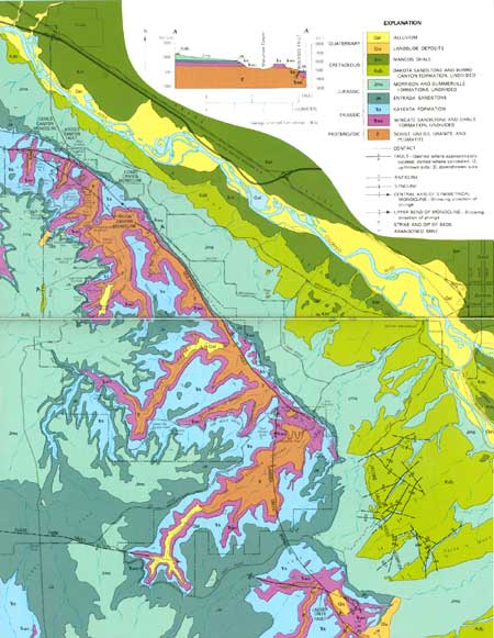
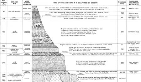
Let us consider these layers one by one, beginning with the oldest at the bottom, for each is a partial record of events long past. Layers of rock that can be easily recognized and distinguished from other layers are called formations and are named after a place where they are well exposed. For the name to be accepted for general usage it must be the first published description in a technical report of a particular sequence of rock layers. The places after which the formations of the Monument were named are given in the rock column (fig. 7), and the outcrops of the formations are shown on the geologic map (fig. 8). In the pages that follow, the geologic events that shaped the Monument we see today are discussed in chronological order, beginning with the oldest rocks that floor the deep canyons.
|
| ROCK COLUMN OF COLORADO NATIONAL MONUMENT. 1 foot = 0.305 meter. (click on image for an enlargement in a new window) (Fig. 7) |
Ancient Rocks and Events

THE DARK ROCKS that floor all the large canyons of the Monument (fig. 6) and form the high bluffs along the north eastern boundary (figs. 37, 38, 40, 41) are of early Proterozoic14 age—among the oldest known rocks of the Earth. Most were once sand and mud that spread out on the bottom of the sea and later hardened into sedimentary rocks (fig. 9-1). After thousands of feet of such rocks had accumulated, they were squeezed, bent, and lifted up by slow but mighty movements of the Earth's crust to form high mountains perhaps like the Rockies. Heat and pressure that developed at great depth in the roots of these mountains changed the sediments into metamorphic rocks known as schist (finely banded) and gneiss (coarsely banded) (fig. 9-2). The rocks are about 1-1/2 billion years old (fig. 7).
14The Geological Survey has divided the Precambrian into, from oldest to youngest, the Archean and Proterozoic Eons, with the boundary at 2,500 million years. The two eons now constitute Precambrian time.

|
|
1 Layers of sand, mud, and other sediment accumulated
in the sea and later were hardened into sedimentary rocks. 2 The strata were compressed, bent, and uplifted into high mountains. Heat and pressure at great depth changed the sediments into banded schist and gneiss. 3 Molten rock flowed upward along cracks or faults. Upon cooling it formed lava at the surface and granite or pegmatite beneath. 4 During eons of time the forces of erosion wore down the mountains to a nearly level plain. BLOCK DIAGRAMS OF EARLY PROTEROZOIC EVENTS (after Edwin D. McKee). (Fig. 9) |
Later in Proterozoic time, about a billion years ago, molten material from below was forced upward along cracks or faults and cooled slowly to form thin seams or dikes and irregular bodies of granite (fig. 9-3). Dikes are called pegmatite when they contain large crystals of pink feldspar, white or clear quartz, black tourmaline, and large flakes of white mica. Small pegmatite dikes that pass through the older schist and gneiss may be seen along roadcuts in Fruita and No Thoroughfare Canyons.
A Great Gap in the Rock Record

IF YOU LOOK DOWN into any of the large canyons in the Monument, you will notice a brick-red formation, the Chinle, which forms steep slopes at the foot of the high cliffs and lies upon the dark Proterozoic rocks along nearly straight lines of contact. Such a straight-line contact is particularly well shown about midway up the high bluffs along the northeastern boundary of the Monument (fig. 37). If the red layer and all overlying rocks were stripped away, these straight lines would be the exposed edges of a remarkably smooth, nearly flat erosion surface on the top of the dark Proterozoic rocks, as shown in the last diagram of figure 9. A vast amount of time passed between the carving of this surface and the deposition of the red Chinle, and no record of the events during this time is preserved in the Monument.
During the latter part of the Proterozoic Eon and parts of the long Paleozoic Era that followed, the dark rocks were submerged beneath the sea several times and received sediments now found in areas to the northeast and southwest. Beginning in the Pennsylvanian Period some 330 million years ago (fig. 61), a large upfold of the rocks, or anticline (fig. 27), known to geologists as the Uncompahgre Highland, rose high above sea level, probably reaching its highest level in Late Pennsylvanian or Permian time. This old highland formed an imposing chain of mountains in about the position of the present Uncompahgre Plateau.
After the old rocks were pushed up into these high mountains what became of them? From the moment the mountains began to rise, their rocks were buffeted by wind, pounded by rain, pried open by frost, scoured by debris-laden streams and, perhaps by glaciers, and the loosened rock particles were dissolved or carried to the sea. Most rocks are brittle enough to crack when bent by Earth forces. Such cracks, called joints, are easy targets for erosion. The freezing of water in joints tends to pry the rocks apart. The breakup of the rocks was hastened by the chemical attack on rock minerals by water charged with oxygen and carbon dioxide. When land plants became established in later geologic eras, soil acids formed from decaying vegetation also assisted materially in breaking up the rocks.
These same erosion processes are going on today, but their effects are scarcely noticeable from year to year except in soft earth after storms or floods. During eons of time, however, the mountains were again worn down to a nearly level plain. Missing between the red Chinle and the dark rocks are many thousands of feet of rocks, some of which once covered this surface and still occur in other regions less affected by erosion. This gap in the rock record, which represents more than a billion years, is known to geologists as a great unconformity. Missing are part of the lower Proterozoic rocks, all the upper Proterozoic rocks, all those of the Paleozoic Era, and part of those of the Triassic Period of the Mesozoic Era. (See figs. 7 and 61.)
Traces of primitive life have been found in some Proterozoic rocks in the form of lime-secreting algae and casts of worms, but no fossils of more advanced types have been found because at that time the primitive animals seemingly had not yet developed shells or skeletons. The ensuing Paleozoic Era saw the appearance and great development of shellfish, fish, amphibians, reptiles, and primitive plants. Some of the rock layers of ages missing at the Monument may be seen as near as Glenwood Springs to the northeast and Gateway to the southwest.
| <<< Previous | <<< Contents >>> | Next >>> |
bul/1508/sec7.htm
Last Updated: 8-Jan-2007
