
|
Geological Survey Bulletin 1508
The Geologic Story of Colorado National Monument |
RÉSUMÉ OF GEOLOGIC HISTORY AND PARKS
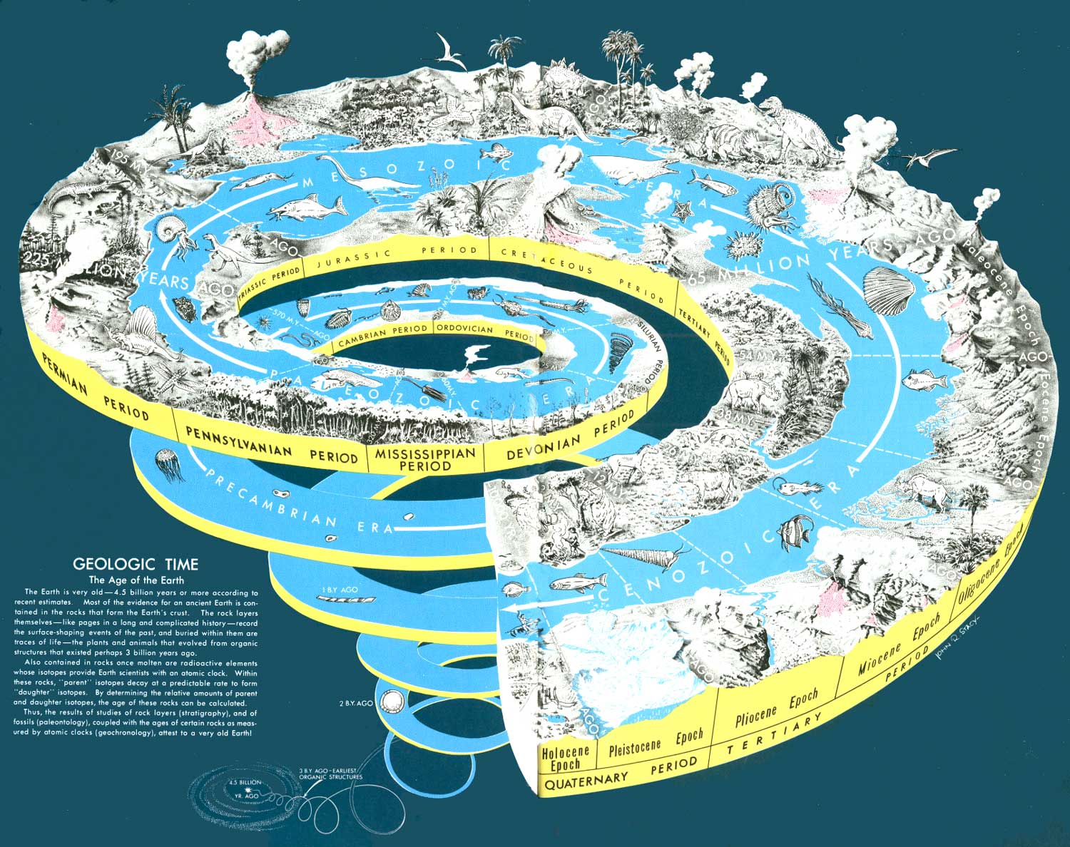
IN THE GEOLOGIC STORY of the Monument discussed on pages 17 to 94, the geologic processes and events leading to the Monument of today were told in the order in which they occurred; therefore, the details of the geologic history have already been covered. Having finished this story and the trips through and around the Monument, let us see how the colorful canyons, cliffs, and other erosion forms fit into the bigger scheme of things—the geologic age and events of the Earth as a whole, as depicted in figure 61. As shown in figure 7, the rock strata still preserved in the Monument range in age from Proterozoic to Cretaceous, or from about 1,500 million to 100 million years old—a span of about 1,400 million years. This seems an incredibly long time, until one compares figures 7 and 61, and notes that the Earth is some 4,500 million years old, and that the rock pile in the Monument is only about a third the age of the Earth as a whole.
|
| GEOLOGIC TIME SPIRAL (overleaf), showing the sequence, names, and ages of the geologic periods and epochs, and the evolution of plant and animal life on land and in the sea. The primitive animals that evolved in the sea during the vast Archean and Proterozoic Eons left few traces in the rocks because they had not developed hard parts, such as shells, but hard-shell or skeletal parts became abundant during and after the Cambrian Period. This drawing was made when the Geological Survey and most others used the term Precambrian to embrace what is now included in the Archean and Proterozoic Eons. The end of the Archean Eon and beginning of the Proterozoic Eon has been placed at about 2,500 million years ago. Also, because of more recent radiometric dating, the ages of the boundaries between some of the geologic periods and epochs have been changed slightly. Of most concern to this report, the boundary between the Pliocene and Pleistocene Epochs has been changed from 3 million to 2 million years. Drawn by John R. Stacy originally for inclusion in a report by Newman (1976). (click on image for an enlargement in a new window) (Fig. 61) |
But this is not the whole story. As indicated earlier, younger Mesozoic and Tertiary rocks more than 1 mile thick that once covered the area have been carried away by erosion, and, if we include these, the span is increased by another 50 million years or so.
If we consider the geologic formations that make up the national parks (N.P.), national monuments (N.M.) (excluding small historical or archaeological ones), Monument Valley, San Rafael Swell, and Glen Canyon National Recreation Area, all in the Colorado Plateau, it becomes apparent that certain formations or groups of formations play starring roles in some parks or monuments, some play supporting roles, and in a few places the entire cast of rocks gets about equal billing. Let us compare them and see how and where they fit into the "Geologic Time Spiral" (fig. 61).
Dinosaur N.M. and Colorado N.M., with exposed rocks ranging in age from Proterozoic to Cretaceous, cover the greatest time spans (nearly 2 billion years), but most of the rocks are missing at Colorado N.M., as noted below. Dinosaur N.M. has one unit—the Jurassic Morrison Formation—in the starring role, for this unit contains the many dinosaur fossils that give the monument its name and fame, although there are several older units in supporting roles. Grand Canyon N.P. is next, with rocks ranging in age from Proterozoic through Permian (excluding the Quaternary lava flows), but here is truly a team effort, for the entire cast gets about equal billing. Canyonlands N.P. stands third in this category, with rocks ranging from Pennsylvanian to Jurassic, but we would have to give top billing to the Permian Cedar Mesa Sandstone Member of the Cutler Formation, from which The Needles, The Grabens, and most of the arches were sculptured. The Triassic Wingate Sandstone and the Triassic(?) Kayenta Formation get second billing for their roles in forming and preserving Island in the Sky and other high mesas. Now let us consider other areas with only one or few players in the cast, beginning at the bottom of the time spiral. Black Canyon of the Gunnison N.M., cut entirely in rocks of early Proterozoic age with only a veneer of much younger rocks, obviously has but one star in its cast. Colorado N.M. contains rocks ranging from Proterozoic to Cretaceous (equal to Dinosaur in this respect), but Colorado is unique in that all rocks of the long Paleozoic Era and some others are missing from the cast. Of those that remain, the Triassic Wingate and the Triassic(?) Kayenta are the stars, with strong support from the Jurassic Entrada Sandstone and from the Proterozoic rocks, which floor the U-shaped canyons.
All the bridges in Natural Bridges N.M. were carved from the Permian Cedar Mesa Sandstone Member of the Cutler Formation, also one of the stars in Canyonlands N.P. In Canyon de Chelly (pronounced dee shay) N.M. and Monument Valley (neither a national park nor a national monument, as it is owned and administered by the Navajo Tribe), the De Chelly Sandstone Member of the Cutler Formation—a Permian member younger than the Cedar Mesa—plays the starring role.
Wupatki N.M. near Flagstaff, Ariz., stars the Triassic Moenkopi Formation. Petrified Forest N.P. (which now includes part of the Painted Desert) has but one star—the Triassic Chinle Formation, in which are found many petrified logs and stumps of ancient trees. The Triassic-Jurassic Glen Canyon Group, which includes the Triassic Wingate Sandstone, the Triassic(?) Kayenta Formation, and the Triassic(?)-Jurassic Navajo Sandstone, receives top billing in recently enlarged Capitol Reef N.P., but the Triassic Moenkopi and Chinle Formations enjoy supporting roles.
The Triassic(?)-Jurassic Navajo Sandstone, which has a supporting role in Arches N.P., is the undisputed star of Zion N.P., Rainbow Bridge N.M., and Glen Canyon National Recreation Area. The Navajo also forms the impressive reef at the east edge of the beautiful San Rafael Swell, a dome, or closed anticline, now crossed by Highway I-70 between Green River and Fremont Junction, Utah.
As we journey upward in the time spiral (fig. 61), we come to the Jurassic Entrada Sandstone, which stars in Arches N.P., with help from the underlying Navajo Sandstone, and a supporting cast of both older and younger rocks. The Entrada also forms the grotesque erosion forms called "hoodoos and goblins" in Goblin Valley State Park, north of Hanksville, Utah.
Moving ever upward in the spiral, we come to the Cretaceous—the age of the starring Mesaverde Group, in which the caves of Mesaverde N.P. were formed, and which now house beautifully preserved ruins once occupied by the Anasazi (the ancient people who once dwelt in many parts of the Plateau).
This brings us up to the Tertiary Period, during the early part of which the pink limestones and shales of the Paleocene and Eocene Wasatch Formation were laid down in inland basins. Beautifully sculptured cliffs, pinnacles, and caves of the Wasatch star in Bryce Canyon N.P. and in nearby Cedar Breaks N.M. This concludes our climb up the time spiral, except for Quaternary volcanos and some older volcanic features at Sunset Crater N.M., near Flagstaff, Ariz.
Thus, one way or another, many rock units formed during the last couple of billion years have performed on the stage of the Colorado Plateau and, hamlike, still lurk in the wings eagerly awaiting your applause to recall them to the footlights. Do not let them down—visit and enjoy the national parks and monuments of the Plateau, for they probably are the greatest collection of scenic wonderlands in the world.
ACKNOWLEDGMENTS

I AM GRATEFUL to many friends and colleagues not only for help on the present report, but also for help on the two preceding reports which made this one possible. I refer to my Professional Paper 451,38 which supplied the detailed geologic data and to the first popular-style booklet.39 First of all, I must acknowledge the great help rendered by members of my family—my eldest son Bill for serving as my unpaid field assistant for most of the detailed mapping of the Grand Junction area, and my two younger sons Terry and Bob for similar services during the last phases of the fieldwork. I am especially indebted to my wife Ruth for material assistance in all the fieldwork, including the road logging and the color photography for the present report.
38Lohman. 1965a.
39Lohman, 1965b.
I am grateful to several colleagues of the Geological Survey and National Park Service for help, data, or reviews of all three reports noted, and to members of my family for reviewing both popular-style reports.
For reviewing the present report I am especially indebted to David V. Harris, Emeritus Professor of Geology, Colorado State University; Harry A. Tourtelot, Geologist, U.S. Geological Survey, for reviewing both popular-style reports and contributing petrographic studies to the detailed report; and to my wife, Ruth.
The comments and criticisms of all reviewers were carefully considered and most were adopted, but in some places I have preferred to state things in my own way, and have included topics that seemingly were of more interest to me than to some of the reviewers. The responsibility for the form and content of this report thus remains mine.
| <<< Previous | <<< Contents >>> | Next >>> |
bul/1508/sec13.htm
Last Updated: 8-Jan-2007