
|
Geological Survey Bulletin 1673
Selected Caves and Lava Tube Systems in and near Lava Beds National Monument, California |
INTRODUCTION
(continued)
Exploring the Caves
For safety or conservation reasons certain caves may be closed to the public or have restricted access. As of April 1990, only Mushpot Cave is lighted, and two of the caves described in detail have restricted access: Crystal and Fern Caves. Always check in at the Visitor Center for information regarding cave access as well as safety and exploration guidelines before entering any cave in the monument.
Time did not permit preparation of geologic maps for all caves in the monument. We did, however, explore a large number of the known caves. Most caves in the wilderness area of the monument were rejected for mapping, not only because of their remoteness, but because most of the deep tubes have collapsed and only small remnants of little geologic interest remain. However, Craig Cave and Craig Temple, accessible only by an 11-mi drive over rough, unpaved roads or a 3-mi hike across rugged terrain, were mapped because of this lava tube's geologic importance and large size. Fortunately, the group of caves whose easily accessible entrances lie adjacent to Cave Loop Road (maps 1-7, pls. 1 and 2) provide excellent examples of nearly all features typical of lava-tube caves.
Cave Names
Nearly all caves and many other geographic features within Lava Beds National Monument were named by J. D. Howard, an early settler and guide whose chief avocation became the discovery, naming, and measuring of the caves. He also assisted in the building of wagon roads so others could visit these natural wonders. From 1917 until about 1933 it appears that he spent almost all of his spare time searching for caves and generally exploring all parts of the northeastern one-third of the Medicine Lake shield. Howard was also a self-educated student of the classics, especially Greek and Roman history and mythology. This is evident in many of the names he used such as Catacombs Cave whose many side passages reminded him of the burial places of ancient Rome. Also, Cleopatras Grave, a coffin-shaped rafted block embedded in the pahoehoe floor of a lava tube in a distant part of Catacombs Cave reminded him of an Egyptian sarcophagus (fig. 13). After J.D. Howard's death, Ranger James R. Valentine compiled an interesting document from Howard's field notes and other written observations. It is on file at the monument.

|
| Figure 13. Sketch of rafted block (RB) framed by two large pahoehoe ropes (LPR) projects above a flow of intricately dragged out small pahoehoe ropes (SPR). Coffin-shaped block in Catacombs Cave (see fig. 14) is named Cleopatras Grave (map 3, pl. 1). |
In recognition of this area's spectacular natural features and because of the role they played in the Modoc Indian War of 1872-73 (Riddle, 1914, reprinted 1973; Murray, 1959; Thompson, 1971; Brown, 1970, p. 213-234; Waters, 1981), an area of 76 square mi was set aside by President Calvin Coolidge (Proclamation #1755) on November 21, 1925 as Lava Beds National Monument.
Cave Maps and Descriptions
Most of this report is devoted to the description of selected lava-tube caves in Lava Beds National Monument (herein, "monument" refers to the Lava Beds National Monument). The text for each map is headed with the number and title of the map. The order of presentation is related to the local geography. Caves with easily accessible entrances near Cave Loop Road (maps 1-7, pls. 1 and 2) are most frequently entered by park visitors, so they are described first. Consult the location map of the Cave Loop Road area (fig. 14) to find cave entrances and to understand how the lava-tube systems are related to each other.

|
| Figure 14. Location map of Cave Loop Road area showing lava-tube systems and cave entrance locations. Unlabeled roads in upper-right corner of map are shown in detail on map 1, pl. 1. (click on image for an enlargement in a new window) |
Mushpot Cave (map 1, pl. 1) is lighted and contains an underground lecture facility and a trail. The entrance to Mushpot Cave is by a stair through a small hole in the cave's roof located within the parking lot at the Visitor Center. Mushpot, Lava Brook, Arch, and Indian Well, Doc Yock, and Stinking Caves are shown on map 1, plate 1, "Lava-Tube Caves of the Headquarters Area." Map 2, plate 1, "Labyrinth Cave System," continues map 1 to the south. It, too, contains several interconnected but separately named caves. Among its larger segments are Golden Dome, Labyrinth, Hopkins Chocolate, short openings within the Garden Bridges area, and Blue Grotto.
Catacombs Cave (map 3, pl. 1), Ovis Cave and Paradise Alleys (map 4, pl. 2), Natural Bridge area (map 5, pl. 2), Hercules Leg and Juniper Caves (map 6, pl. 2), and Sentinel Cave (map 7, pl. 2) complete the sequence of cave maps around Cave Loop Road. The map of the Natural Bridge area shows the large and spectacular collapse trenches that are one of the main visitor attractions of this particular area. Cave Loop Road changes direction by crossing over a large natural bridge between two of these breakdowns. Several small and short lava tubes, including Juniper Pole and Sunshine Caves, as well as short sections of the large feeder tubes beneath the Natural Bridge, are shown on map 5, plate 2.
Outside of the Cave Loop Road area are several caves easily reached by improved roads: Valentine Cave (map 8, pl. 3), Tickner and Berthas Cupboard Caves (map 9, pl. 3), Heppe Caves and the Mammoth Crater-Hidden Valley area (map 19, pl. 6), Merrill Ice and Bearpaw Caves (map 10, pl. 4), Kirk Whites, Beaconlight, and The Igloo Caves (map 11, pl. 4), Skull Cave (map 12, pl. 4), and Boulevard, Balcony, and Sharks Mouth Caves (map 13, pl. 4).
Silver Cave (map 14, pl. 5), Post Office Cave (map 15, pl. 5), Craig Cave (map 16, pl. 5), Crystal Cave (map 18, pl. 6), and Fern Cave (map 17, pl. 5) are in remote areas or are restricted to entrance only with permission, but these five are among the most interesting in the monument.
The above listing is by no means the order to follow in visiting the caves. A much more logical order for anyone who wants to visit three or four caves to get an overall view of lava tubes would be Mushpot, Catacombs, Ovis, and Merrill Ice or Skull. Those people with specific interests who may want to spend several days or weeks exploring the caves should first examine the maps and pick out the areas that seem of interest. Perhaps the following brief paragraphs may help to develop a plan that will save time and increase the enjoyment and productivity of your stay:
1. The novice to cave exploration should start with Mushpot and Lava Brook Caves to acquire confidence in traversing and understanding near surface lava-tube systems. Catacombs is excellent for a followup, and so is Valentine. For examples of deep and large "feeder tubes" start with a small remnant such as Ovis, or Heppe, follow up with Craig, and then graduate by tracing the Cocoa Pipeline, if accessible, through its full length in Post Office Cave.
2. The geologist interested in the mechanics and hydraulics of lava-tube formation and development will find Post Office, Tickner, Berthas Cupboard, Crystal, Skull, Catacombs, and Valentine among the most instructive caves to study. For lava tubes that invaded cinder cones or other tuffaceous sediments see Skull, Crystal, Kirk Whites, Beaconlight, and some small but deep caves (unmapped) near Schonchin and Bearpaw Buttes (Castle and White Lace for example).
3. The student of ice formation within caves will find Crystal Cave of special interest. Access is limited (as of April 1990) to small groups by prearrangement in wintertime only so as not to damage the fragile ice formations. Other caves that usually contain much smaller amounts of frost and ice are Skull, Merrill Ice, Captain Jacks Ice, Frozen River, Caldwell Ice, and Upper Ice Cave.
4. People interested in early Indian cultures will find the best displays of pictographs in Fern Cave. Other good localities are among the breakdowns between Skull and Merrill Ice Caves, especially near Symbol Bridge. Petroglyphs are well exposed in both Juniper Cave and in a separate and protected area of the monument at Prisoners Rock (fig. 15), northeast of the main area of the monument and 2.5 mi southwest of the town of Newell.
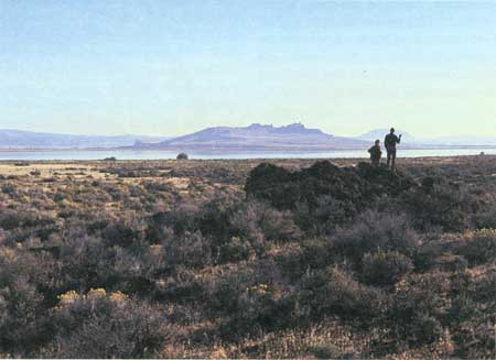
Figure 15. View northeast across Tule Lake to The Peninsula and Prisoners Rock where the Petroglyphs section of Lava Beds National Monument is located. Photograph taken from near Hospital Rock, in northeastern part of monument. 5. Those interested in the microclimate adaptations of plants will find the Garden Bridges, easily reached from Cave Loop Road, a rewarding area. The breakdowns and numerous short cave remnants within a small area provide variations from moist cool air at cave entrances to the dry sun-baked roof tops over caves. Examine the Natural Bridge area as well. Fern cave is named for the large population of ferns (rare in this desert region) that cover its entrance mound. The greenhouse-like atmosphere of this cave is in stark contrast with the dry air above ground. Fern Cave is kept locked, but tours can be arranged by contacting National Park Service personnel at the Visitor Center.
Each cave description herein should be read with the respective map unfolded beside it because most of the text material is tied directly to the map.
Preparation of the Maps
Planetable and alidade traverses were made in mapping the larger lava tubes, and a description of the procedure follows. A station is occupied, and a sight through the alidade is taken on a miner's lamp or flashlight placed at the next station. Distance between stations is measured with a stretched steel tape, and orientation at a new station is controlled by backsight to the former station. Position of the walls is obtained and plotted directly on the planetable sheet: an assistant walks beside the steel tape, carrying a lightweight stadia rod to measure the distance (horizontally at right angles to the tape) of all points where the wall of the cave changes direction. At each of these points he calls out the distance on the tape, and then the distance to the wall, to the person operating the planetable, who immediately scales off and plots this point on the planetable sheet. After both walls have been drawn, the positions of geologic features—such as balconies, skylights, breakdowns, rafted blocks, collapse piles—are plotted, using the stadia rod to measure their outlines with reference to the tape. The height of the ceiling above floor is determined at selected points with the stadia rod held vertically or if the roof is too low, with a folding rule. The heights of benches, balconies, lava cascades, and other salient features are obtained and plotted on the planetable sheet. Thus a rough draft of the map is prepared continuously as the traverse is extended.
Before a traverse of more than a few hundred yards was completed, we nearly always encountered passages too small for the planetable to be leveled on its tripod, or we had to extend the traverse through crawlholes along the side or roof of a cave. In such situations we used cloth tape and a Brunton compass (a compass with attached clinometer to measure angles) to extend the traverse until the planetable-alidade work could be resumed. At first we were concerned about the magnetic errors that might arise from using a Brunton in such close proximity to basalt lava. To our surprise, repeated checks showed that large magnetic deviations are not a problem in caves but are common when a Brunton is used on top of a prominent basalt outcrop. Apparently, this discrepancy is caused by lightning strikes on a surface outcrop of basalt that produce magnetic changes great enough to strongly affect the needle of a Brunton.
Acknowledgments
A project to map selected lava-tube caves within Lava Beds National Monument was initiated by Paul F. Haertel, former Superintendent of the monument, in 1974. At Haertel's request, Aaron Waters agreed to do the cave mapping and to prepare a report on each major cave. In 1974 Eric Pittenger and William Ruddiman III from Oregon State University assisted in the fieldwork. Jamie Gardner and David Kimbrough from the University of California, Santa Cruz, joined William Ruddiman III and Waters during the 1975 field season. In 1976 Alison Till, also of U.C. Santa Cruz, and Waters returned for one month to complete some details of the underground mapping, and to map some of the important lines of surface breakdowns. The cave mapping was completed and mylar copies of all cave maps and descriptive reports were delivered to the National Park Service in 1977. Subsequent to this work, Julie Donnelly-Nolan began work in the monument in 1979, and that work resulted in a surface geologic map (Donnelly-Nolan and Champion, 1987). She updated the geologic interpretations in this book and added some figures and references. Where interpretations in this bulletin differ from those on the surface map, the interpretation is that of the first author in each case. Bruce Rogers redrafted and added to many of the maps and their descriptions and contributed new figures including many new photographs. Keith Howard reviewed the manuscript. James O. Sleznick, Superintendent of the monument from 1978 to 1986, encouraged publication of the cave maps and descriptions. Janet Sowers and other National Park Service personnel provided useful information.
| <<< Previous | <<< Contents >>> | Next >>> |
bul/1673/sec1a.htm
Last Updated: 28-Mar-2006