
|
Geological Survey Bulletin 1673
Selected Caves and Lava Tube Systems in and near Lava Beds National Monument, California |
CAVES EASILY ACCESSIBLE FROM CAVE LOOP ROAD
Lava-Tube Caves of the Headquarters Area
The Cave Loop Road area, south of the Headquarters building, is composed of many small and large lobes of lava, most of which subdivide downstream into new lobes. Many of these lobes contain from one to several small lava tubes, which also may bifurcate and spread out like the distributaries on a delta. Beneath this complex pile of overlapping lava lobes and lava tubes is a chain of large feeder tubes, which delivered molten lava from Mammoth Crater to this area and also far to the northeast. Figure 14 shows some of the complex relations in this set of tubes that originated at Mammoth Crater. Figure 4 shows that this is only part of a much larger array of lava tubes in the basalt of Mammoth Crater (Donnelly-Nolan and Champion, 1987).
Mushpot Cave
The entrance to Mushpot Cave is a hole in its roof, located in the parking lot that serves the Visitor Center and Headquarters building (map 1, pl. 1). This is the only cave in the monument that contains lights and interpretive signs, which point out geologic features. It is an excellent place to get acquainted with lava-tube caves. A staircase leads to the floor of the cave, and from this point one can traverse the main branch of Mushpot lava tube downstream (northeast) for 520 ft. Upstream the tube is blocked 25 ft south of the foot of the stair by a floor jam of broken and deformed lava blocks.
Downstream 65 ft from the entrance the main tube widens into a broad dome-like area and is intersected on its southeast wall by another wide tube, which diverted part of the flow in Mushpot tube to the east. Only about 50 ft of the length of this east flowing tube is visible because both upstream and downstream it is filled to its roof with congealed lava. Yet another tube, a small tributary, spilled a thin flow of rough-surface pahoehoe into the main tube at a point low on the west wall 25 ft downstream from the foot of the stairway. This small tributary is accessible only by crawling for 180 ft, where further access upstream is blocked by a lava lobe that leaves just a 6-in. space between floor and roof.
Features Near Entrance
Upon entering Mushpot Cave pause about halfway down the staircase and look around. An open lava-tube cave extends downstream on the right and an alcove extends upstream on the left. Notice that the walls of this alcove are covered with lava dripstone—a thick plaster of sticky lava that oozed and dripped down the wall in thin lobes as the surface of molten lava lowered within the tube. Similar dripstone, somewhat obscured by lichens and dirt, extends to the top of the entrance pit on the east and south; the presence of this dripstone indicates that this entrance was a former skylight—a hole in the roof of the tube that was open to the sky while molten lava was in the tube. Most entrances to lava tubes are not former skylights; they have been opened by collapse of a part of the roof long after volcanism ceased. Actually, some collapse has occurred on the west side of this skylight. Note that this overhanging west edge is not covered with dripstone but instead was pared back by blocks that tumbled from it and were carried away in the molten flood. One large block that fell from this edge was too heavy for transport; it landed on the floor of the alcove at a point just upstream from the foot of the stairs. Examine its rounded top and sides and note that it is completely plastered over with a thin coating of lava which is smooth on the top and pulled into dripstone on the sides. After its tumble this block was completely immersed in the molten lava flowing down the tube.
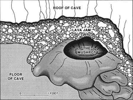
Descend to the foot of the stairs and inspect the upstream end of the cave before starting on the trail downstream. Looking upstream from the base of the stairs, one of the first things you notice is the feature that gives the cave its name—a small rounded mound of smooth lava with a hole in its top (fig. 16). Sticky lava emerged from this hole, spread radially, and built up a low cone, in the same way boiling porridge spills from an overfilled pot. Peer into the hole at the top of this Mushpot bubble, and you can see at a depth of 2 ft a miniature tube inside the thin smooth lobe of yellowish lava, which floors this part of the chamber. The opening through which the lava porridge spilled out is a skylight on the top of this tiny tube-in-tube. The tube-in-tube developed as a later flow of lava flowed along the larger tube. The Mushpot bubble and the tiny tube-in-tube beneath it were produced by leakage through a lava jam that blocked the main tube. This trickle of smooth yellow lava can be followed down the floor of Mushpot tube, as a narrow lobe, to its terminus about 20 ft downstream from the stairway (west of the trail).
|
| Figure 16. Drawing of Mushpot bubble, which was formed by overflow through tiny hole in small lava tube. The small lava tube was formed by trickle of lava that leaked through the floor jam of blocks which forms the upstream termination of Mushpot Cave (see map 1, pl. 1). |
Crouch beside the Mushpot bubble so you have a clear view upstream (south) and you will see the lava jam blocking the tube (fig. 16). Filling a 3-ft space between floor and roof of the tube is a jumbled mass of frothy and distorted lava blocks—the crusted-over surface of a moving flow that broke and stuck, creating a constriction comparable to an ice jam in an Arctic river after the spring thaw. Note that the roof of the cave against which the lava has jammed is covered with lavacicles, some of which punctured the rising lava-jam blocks. Notice that these lavacicles embellish the roof of the cave not only here, but also above the Mushpot bubble and down the course of the Mushpot tube. The lava jam blocked the tube for only about 30 ft; the upstream area beyond this jam is in Lava Brook Cave (map 1, pl. 1).
High-Lava Marks
Another important feature well displayed in the area that contains Mushpot bubble is a high-lava mark, similar to that of a flood mark left by a river. One high-lava mark is present 20 in. above the floor on the east wall of the tube in the alcove containing the Mushpot bubble. It marks the maximum depth of lava before the jam blocked the tube. Note that the mark is plastered across the dripstone wall of this alcove. One small patch of dripstone at the south end merges with the high-lava mark, and one small tongue of dripstone that slid off the side of the fallen block at the stairs is younger. These small patches of dripstone may be from lava that splashed up onto the wall by violent emission of gasses ("fountaining") of the flow that produced the high-lava mark. Follow the high-lava mark downstream—it is not continuous because it is covered or removed in places by collapse or by human activities connected with trail construction. It slopes downstream, but at a lower gradient than the surface of the flow that now forms the floor of the tube. At the Mushpot the high-lava mark is 20 in. above the floor. Where the intersecting distributary tube takes off into the east wall 80 ft farther downstream, the high-lava mark is 6 ft above the floor and five other faint high-lava marks visible below it mark brief halts in the lowering of the lava flood. Three of the most conspicuous ones are present on the peninsula-like hump that flares out from the wall of the eastern distributary at the junction of the two tubes. Trace these high-lava marks back upstream toward the Mushpot and note that all converge southward. To the north, the top one rises to the roof of the tube; the trace of this high-lava mark indicates that below this point the Mushpot tube was completely filled with lava.
Eastern Distributary
The Mushpot tube is abnormally wide in the area where it is joined by its western tributary and its eastern lava-filled distributary (see map 1, pl. 1). Note also that the roof is abnormally high, 9-13 ft, over the eastern half of the tube in this area but is abnormally low (3-4 ft) in the western half of this wide tube, providing only crawlspace. Three pillars connect roof and floor in the western part. Directly across Mushpot tube from this area of pillars, the large distributary tube takes off into the eastern wall. It is larger than Mushpot tube but is filled almost to its roof with lava. Its roof is only 3 to 4 ft above its floor at the junction with Mushpot tube, but downstream 35 ft east of Mushpot tube the roof rises to a maximum height of 6 ft in a partly collapsed dome. The northern half of this dome was destroyed by a roof collapse before the final flow of lava occupied the tube. The swirling action of spiny pahoehoe against the collapse blocks left a high-lava mark 1-3 ft above the present tube floor. Collapse blocks above this high-lava mark are loose and were never covered by lava. East of the collapse pile the floor of congealed lava intersects the top of the tube in a wide arc, but at the northeast corner the pahoehoe surface swirls to the right, the tube steepens, narrows, and is closed shut in the top of a cascade of spiny pahoehoe.
From these relations, it seems apparent that the eastern distributary is a somewhat older and deeper tube than the higher Mushpot tube, which collapsed into the distributary in the general area where the Mushpot tube expands to 40 ft in width. The low roof over the west side of the Mushpot tube is, therefore, the continuation of the eastern distributary roof, upstream from the point where the two tubes merge. Lava from Mushpot tube filled the lower distributary tube to its roof, except for the low-ceiling area on the west side of the enlarged Mushpot tube and the 50 ft that the distributary tube extends to the east. Detailed evidence of exactly how the two tubes joined is obliterated by the deep lava fill in the lower tube, but enough of the roof remains to establish the overall relation of one tube to the other.
Western Tributary
The western tributary is a small tube, less than 6 ft wide and 3 ft high. It is floored by a small stream of spiny pahoehoe, in places only a few inches thick. In the upper part of the tube the lava flowed along an incline of 11° for 54 ft. A traverse up this tube is strictly a crawl; in only one spot, adjacent to the small pillar halfway along this passage, is it possible to stand upright. Access to Lava Brook Cave is blocked upstream by a passage less than 6 in. high, but this same point can be approached in the tube's continuation for 20 ft as a distributary from Lava Brook Cave.
Balconies and Skylights
Downstream along the Mushpot tube trail, beyond the complex area of tube junctions, are three features that interrupt the smooth contours of the cave's arched roof and walls.
The largest is a balcony located 130 ft downstream from the cave entrance. It hangs as a graceful semicircle 9-12 ft above the floor of the tube. The smooth upper surface of the balcony is plastered against the upstream half of a dome in the roof of the tube. It probably formed when a lava pool filled most of the tube completely but rose only part way to the top of the dome. Cooling lava at the top of the pool evidently attached to the tube walls and formed a narrow platform. Before thickening, the lava beneath the platform drained out of the tube and left the platform hanging at its present level. This crescentic balcony overlooks the underground lecture hall on the floor of the cave.
A second feature in the cave's roof is located another 160 ft farther downstream. It resembles part of a culvert from which the bottom half has been removed. This rounded ceiling channel can be followed for 35 ft along the top of the larger tube, until it turns into the south wall and is lost within a few feet under a plaster of dripstone. It definitely records the presence of a small open lava tube, only about 8 ft in diameter, whose floor collapsed into the large Mushpot tube below.
The third and highest feature is a niche in the south wall 17 ft above the tube floor. This niche is part of a high and narrow cupola in the tube's roof. It is located at the sharp bend 150 ft upstream from where the main tube is blocked by ponding of lava. The cupola and niche probably are a roofed-over skylight in the tube's ceiling. Its original walls are obscured by a plaster of dripstone. Many of the thin plates of lava that formed by the bridging of congealing lava in skylights—as observed on active lava tubes in Hawaii (Greeley, 1971b, 1972; Peterson and Swanson, 1974)—are clearly visible as horizontal ridges partly smoothed over by the dripstone plaster. Repeated freezing-over of the lava surging within this narrow skylight built a cover across a hole, which formerly opened to the surface. When the lava in Mushpot Cave withdrew to its present level, only a cupola and niche in the wall remained to indicate the position of the roofed-over skylight. Today an electric light illuminates the niche. Downstream from this point the trail ends. Though the ceiling is low, you can still crawl for another 100 ft by avoiding two areas of collapse blocks. The tube is closed by a lava filling to its roof.
Dripstone and Lavacicles
Both Mushpot and Lava Brook Caves provide such excellent examples of dripstone and lavacicles (such as those shown in figs. 8 and 9) that further descriptions and locations of these features are useful. Fine examples of lavacicles cover the large domes in the area where Mushpot tube widens at its junction with the eastern distributary. Excellent places to study them more closely at eye level can be found along the main tube roof throughout its length, except in areas of roof collapse. In these areas, many stages and changes in the development of the lavacicle and dripstone plaster are recorded. Many interesting patterns result from the response of molten lavas of varying viscosities to the pull of gravity. On steep and smooth walls, pull-out patches in the dripstone are common (fig. 11). Fine examples of such sloughing are present on the south east Mushpot wall between the large balcony and the roofed-over skylight. Good examples of pull-out patches from a lavacicle-covered roof can be seen on the high domes in the tube junction area. Other interesting forms, better seen in Valentine and Post Office Caves, are near those high-lava marks where the moving lava dragged and distorted hot and sticky dripstone. In places the dripstone is sheared into narrow benches and strips or broken into foliated masses.
Caliche, False Gold, and Phosphorescent Deposits
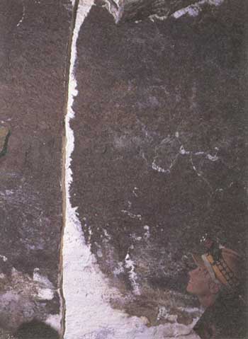
Changes after solidification also produce interesting patterns superimposed upon the lavacicles and dripstone. Water from rain and melting snow seeps down into the caves and then may spread out, wetting the surface of the lavacicles and dripstone. Some of this water evaporates and leaves a thin coat of caliche (calcium carbonate plus minor amounts of other soluble salts and clay) as a white filigree-like tracery upon the dark lava surface beneath (fig. 17). Excellent examples of this lace-like natural ornamentation can be seen on both walls of Mushpot Cave between the large balcony and the roofed-over skylight. J.D. Howard gave the name "White Lace" to a cave with walls of this kind of caliche. If cave walls are completely covered with white caliche, they may show a silver or pale-blue sheen when wet. This phenomenon is the source of the names "Silver Cave" and "Blue Grotto."
|
| Figure 17. White caliche deposit along crack in wall of Post Office Cave (see fig. 4 and map 15, pl. 5). This cave deposit was formed by evaporation of percolating surface water carrying calcium carbonate. |
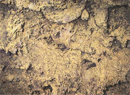
In some areas (notably in parts of Catacombs, Labyrinth, and Valentine Caves) the caliche is pale buff or tan to chocolate brown instead of white because of a higher content of clay, soil humic acids, hydrous iron oxide stains washed in with the calcium carbonate, and the growth of "lava-tube slime" (bacteria and primitive fungi) on the moist walls. Water droplets on this fungi-rich caliche may glow like polished gold when a light is played upon them (fig. 18). This "false gold" is sometimes visible in wet areas of Mushpot Cave and is beautifully displayed on the moist roof and walls of Golden Dome, Hopkins Chocolate, and Valentine Caves.
|
| Figure 18. False gold cave deposits on wall of Golden Dome Cave (see fig. 14 and map 2, pl. 1). Deposit consists of thin coating of fungi-rich caliche. Field of view is 6 ft across. |
Another uncommon but interesting secondary effect, visible in near-surface caves with wet floors, is a flickering greenish glow along the floor, which appears to change color and intensity as light is played upon it. This is phosphorescence derived from the decay of animal droppings on the cave floor, and it is occasionally seen in wet parts of Valentine Cave.
| <<< Previous | <<< Contents >>> | Next >>> |
bul/1673/sec2.htm
Last Updated: 28-Mar-2006