
|
Geological Survey Bulletin 1673
Selected Caves and Lava Tube Systems in and near Lava Beds National Monument, California |
CAVES EASILY ACCESSIBLE FROM CAVE LOOP ROAD
Lava-Tube Caves of the Headquarters Area (continued)
Lava Brook Cave
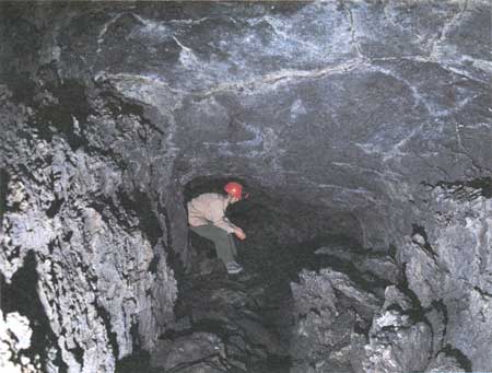
The entrance into Lava Brook Cave (map 1, pl. 1), like Mushpot's, appears to have been a skylight when the lava tube was active. The hole is so small that the two steep stairs built into it—one leading downstream, the other upstream—obscure the walls; however, some dripstone is visible and extends to the surface.
Three Junction Area
For the first 50 ft downstream from the entrance stair, Lava Brook is a small lava tube that is about 8 ft wide, 5-6 ft high, and cluttered with collapse blocks. It then makes an abrupt turn to the right (southeast). Its gradient steepens, and it throws off two small distributary tubes from its left side. The first one, located exactly at the bend, is a small crossover tube that leads to the entrance of East Labyrinth Cave (see map 1, pl. 1).
This crossover tube leaves Lava Brook by dropping abruptly in a 5-ft lava fall. The tube is so narrow and low that it requires stooping or crawling for much of its 125-ft length. In places it is so cluttered with collapse blocks that, except for another lava fall about mid-course, there is nothing to see except collapse features.
The second small distributary heads in the same direction from a point 10 ft farther down the Lava Brook tube. It also immediately drops in a 3-ft lava cascade. Ceiling heights are only 3-4 feet, but the tube is free of collapse blocks and displays fine examples of lavacicles, dripstone, and pahoehoe. After crawling for 32 ft, you will find this direction blocked by lava up to the roof, but the pahoehoe stream that formed the floor actually turns sharply to the left (north), drops abruptly 3-4 ft below its upstream floor, and resumes its course to the northeast. Further access is denied only a few feet beyond the northeast turn by the lava that rose to within 6 in. of the roof. By plotting this point on the maps we found that this tube is the upstream continuation of the tiny tube up which we had crawled 180 ft from the Mushpot tube. Access is blocked for less than 20 ft between them.
Twin Pillars-Sleeping Beauty Area
Returning to the main Lava Brook tube and continuing downstream, we come to two small pillars, with a nest of intersecting benches and lava tubes around them. To understand this complicated area, carry the map and refer to it constantly while examining this part of the cave. The first feature to note downstream is a lava bench, 2 ft high, which begins on the left (north) wall 12 ft downstream from the head of the tiny tube described previously that leads from the Mushpot tube. Beyond this bench the left wall of the tube turns due east, whereas the opposite wall diverges southeast. The main lava channel follows the southeast trend and is bounded on its north side by the lava bench. The gradient steepens, and as the channel deepens the bench of its left side subdivides into two benches; the lower bench ultimately rose 4-5 ft above the floor of the tube downstream. Because of the divergence in direction of the tube's walls, the benches soon widen to a maximum of 18 ft. At the point of divergence, twin pillars connect both benches with the roof of the cave. The higher bench is attached to the north side of the smaller (northern) pillar, and the lower bench clings to the southwest side of the larger pillar. Between the two pillars is a deep cleft. An early rush of molten but viscous magma, which formed the higher bench named "Sleeping Beautys bier," rose in a standing wave 2 ft high and stuck in the upstream end of this cleft. It thus protected the deep cleft from further invasions of molten lava while the benches and channel were built. Moreover, a small tributary from the north was also spilling lava into the main Lava Brook tube just at the downstream edge of the pillars. As the lava from this tributary decreased in volume it carried away what may have been molten or sticky continuations of the benches downstream from the pillars. The same kind of action was probably occurring on the edges of the Lava Brook channel simultaneously. The lava from this tributary appears to have been fed from a tube-in-tube (now filled in), but the last lava emitted cascaded in a curving steep-gradient gutter, which today resembles a ramp making a left turn to join a freeway on a lower level. A further complication is that a much larger tributary joins the Lava Brook tube from the opposite (south) side at the same point. The pahoehoe floor of this tributary tube is at the level of the lower bench, so its mouth hangs 3 ft above the Lava Brook channel. The exact order in which these different benches, gutters, and channels were built is perplexing, but the order of their final abandonment by liquid lava can be worked out. Lava stopped flowing from the south tributary first, then from the main Lava Brook tube, and the final driblet down the tube was out of the curving lava gutter that drained the north tributary.
Mushpot-Lava Brook Floor Jam
Continue down from the Twin Pillars through the main Lava Brook tube on a traverse that runs slightly north of east for 110 ft to where a big tributary intersects this tube from the south. Along the first 80 ft of this traverse, Lava Brook is an ordinary clean tube exposing good lavacicles, dripstone, and a spiny pahoehoe floor. Two long remnants of the 3-ft bench cling to its south wall. About 80 ft below the Twin Pillars the roof of the cave begins to lower, and the lava on the floor pooled and broke up into blocks, which were heaved up in a semisolid state and deformed against one another. Another 5-10 ft farther, these broken and distorted blocks were raised in two giant steps by molten lava, and finally a little farther downstream the heaved blocks were rebroken and jammed tight against the roof. This is the opposite side of the lava jam just upstream from the Mushpot bubble. Access between the two caves is barred by the lava jam over a distance of approximately 30 ft (see map 1, pl. 1). Curiously, no clear evidence was seen that molten lava backed up high enough to fill the tube behind this dam. Apparently the floor jam did not form until the final stages of lava occupancy. The last of the molten lava trickled between the floor jam blocks and formed both the Mushpot bubble and the small lobe of yellowish lava that extends downstream from it.
South Tributary
On returning to the Lava Brook entrance, a side trip to the head of the south tributary is worthwhile, although for about half its length you will have to walk in a stooped position and crawl over the last few feet.
As previously noted, a step up a 2- to 3-ft scarp is required to enter this tube. One can then continue upstream in a particularly clean cave with a well-exposed ropy pahoehoe floor. At 120 ft the source of the lava that built this floor is evident. It is a thin flow that debouches from a gutter down the middle of the tube, leaving benches of older lava on either side. In another 60 ft the entire tube appears to end bluntly in a rock wall, beneath which the gutter disappears as a tube-in-tube. However, there is a narrow opening along the right (north) side of the cave, and by climbing up over a 5-ft lava fall, one can squeeze through and find that the tube opens up to its full width upstream at a level 5-7 ft higher. A small linear breakdown in the floor indicates that the gutter we followed to the lava fall continues beneath the higher level as a tube-in-tube. This upper tube is only 40 ft long. It ends in a wall from which several large blocks have tumbled, revealing an unusually clear example of a tube that had been open at one time but that is now completely plugged with lava. The tube received a tributary from the south, 10 ft downstream from this wall. Solidified lava chokes this tributary nearly to the roof, but by crawling into it and poking a stadia rod out as far as it would go, the shape outlined on the map was obtained. The direction of flow was noted from the pahoehoe ropes.
Lava Brook Cave Upstream from Entrance
The upstream part of Lava Brook Cave is an ordinary tube with a steeper gradient than most other tubes. Upstream 120 ft from the entrance a distributary takes off to the south but ends within 20 ft. Before it ends, however, a narrow gutter plunges beneath its floor, and because this place is only 20 ft from the upstream end of the south tributary tube (see map 1, pl. 1), it appears fairly certain that this is the same tube-in-tube, which broke out as a gutter on the floor of the south tributary just below the 5-ft lava fall.
Upstream 220 ft from the Lava Brook entrance, the Lava Brook tube merges with a collapsed section of the Thunderbolt Distributary. Instead of returning to the Lava Brook entrance from this tube junction, it is more interesting to complete a traverse by turning north and following the Thunderbolt tube downstream and exiting at the East Labyrinth entrance. This section of the Thunderbolt Distributary is known as the East Labyrinth Cave, and it is by far the most interesting part of this tube.
Area Near Thunderbolt Entrance
The area near Thunderbolt entrance (southwest corner, map 1, pl. 1) has undergone extensive roof unraveling. Daylight is visible through cracks and some small holes in the roof, which is barely 2 ft thick.
Thunderbolt Distributary
(East Labyrinth Cave)
The junction of the Lava Brook tube and the Thunderbolt Distributary is approximately midway between the Lava Brook entrance and the Thunderbolt entrance. As you round the corner from Lava Brook Cave and start downstream into the Thunderbolt Distributary, this section of the tube is called East Labyrinth Cave. The last flow of lava to occupy this distributary went down the Lava Brook tube because the downstream continuation of the Thunderbolt Distributary was blocked by a wide spread floor jam. You must pick your way over and around this large jam of disrupted floor blocks for 25 ft. At the downstream end of the jam the two obstructions that caused the lava to jam up are obvious. First, the main flow of lava collided at a 45° angle with and piled up against the east wall of the Thunderbolt tube. Second, the Thunderbolt tube narrows greatly here and opens downstream from this point as a gutter only 4-5 ft wide, with benches 4 ft high on either side. The last flood of lava was not able to turn sharply and pour through this narrow passage. It piled up into a jam of blocks, increased the obstruction, and forced all the late flow into Lava Brook tube.
Continuing downstream below this floor jam, we find that the gutter in Thunderbolt's continuation (East Labyrinth Cave) was roofed over as a tube-in-tube at one stage in its history, for a natural small bridge connects the two benches just downstream from the lava jam. In another 20 ft the gutter widens to 5 ft—the full width of the tube—and the benches are discontinuous from here downstream. One bench, on the south east side, consists of a pile of roof-collapse blocks that were overridden and smoothed out along the tube by moving lava. Where the tube bends, the benches end, and the tube continues almost due north. Benches are absent here, and most of the cave's floor is cluttered with blocks that have tumbled from the roof after volcanism ceased.
Upstream 130 ft from the East Labyrinth entrance is a gutter with benches on either side called Jupiters Thunderbolt. It reappears in the middle of the tube, extends for 50 ft, then dives into the floor on the west wall to continue as a small open distributary branch at a slightly lower level. This distributary is too small to traverse without crawling. Rubble from collapse litters the next 100 ft of the main tube from this distributary junction northeast to the East Labyrinth entrance, where caving-in of the roof has breached the surface.
Downstream from East Labyrinth Entrance
The tube downstream from the East Labyrinth entrance splits into two branches around a pillar 100 ft long and 60 ft wide. Neither branch can be negotiated without a tight crawl, and when you can finally stand you are in a wet section of the cave that receives percolating wastewater from the facilities at the Headquarters building and the Visitor Center. Farther northeast the tube widens and exhibits interesting pillars and benches before ending in a lava seal 60 ft from Arch Cave.
Arch Cave
Arch Cave (map 1, pl. 1) is entered through a hole 7 ft wide but only 3 ft high. The cave is the eastern continuation of the East Labyrinth lava tube. It can be traversed for 335 ft and has some very interesting features that can only be reached by stooping or crawling through about half the length of the cave. After 100 ft of low-ceilinged passage you come to a floor jam of lava blocks tilted into an 8-ft lava cascade that leads into a room with a 13-ft ceiling. The cascade marks the place where this shallow, near-surface tube broke through its floor into a larger tube below. Within this room, a pool of lava 10 ft deep fluctuated up and down for some time as shown by high-lava marks on the walls. Marks are also on the walls of another 14-ft-high but smaller room 75 ft farther downstream. In this second room lava dripped down the side of the cave in three small lava cataracts (see map 1, pl. 1). This lava was funneled through cracks in the high-level bench as the lava surged up and down within the upper chamber.
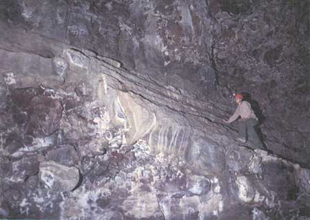
Downstream from this second chamber the tube narrows markedly into a short crawl passage with a ceiling only 2-3 ft high. It then opens up into a "keyhole" passage. This narrow tall tube probably formed by the merging of two levels whose walls were later lined by successive layers of lava plaster. Many layers of this plaster pulled away from the walls while still sticky and coiled down the walls like a jelly roll. Others curled over and broke off or were slowly let down onto the floor in wavy and wrinkled masses as the lava flowed out from beneath them (see fig. 19 and the cross sections on map 1, pl. 1). This keyhole-shaped tube with its strange peeling and curling walls of lava plaster can be traversed for 80 ft. At its end the tube plunges steeply, apparently down a lava cataract, to where the curling masses of plaster clog its continuation completely.
|
| Figure 19. Interior of Arch Cave (see fig. 14 and map 1, pl 1) showing jagged benches and heaved and broken floor. |
Near-Surface Nature of the Headquarters and Labyrinth Area Tubes
From our investigations of these Headquarters area lava tubes, one conclusion needs to be emphasized: all of them described so far, with the possible exception of the eastern distributary of Mushpot Cave, are small near-surface tubes. If you compare map 1 and map 2 (pl. 1), it appears at first glance that all of the lava active in making the remarkably extensive bifurcating caves of the Labyrinth area was finally funneled downstream into the tiny single tube containing the Thunderbolt entrance. This interpretation is, of course, nonsense. What is missing in such an analysis is the fact that nearly all the tubes in both Labyrinth and Headquarters areas disappear downstream because lava filled to their roofs; thus, further tracing of them is impossible. Only the parts that have drained out after cessation of volcanism can be entered, mapped, and studied.
Unquestionably, deep beneath the Headquarters area are scores of tubes filled to their roofs with lava. One example we studied is the eastern distributary of Mushpot Cave, where 70 ft of the roof of a deeper, now-filled tube is visible. We also traced Mushpot, parts of Lava Brook, and Arch Caves downstream to where they are filled with congealed lava.
Well over 85 percent of the deep underground lava "plumbing" system in Lava Beds National Monument was filled with congealed lava and is therefore inaccessible. But accidents of various kinds have, in places, preserved short sections of intact lava tubes. Examples of large remnants in the monument are Crystal, Craig, and Post Office Caves. Indian Well (map 1, pl. 1) and Sentinel Caves (map 7, pl. 2) are easily accessible small remnants on a line upstream with Ovis Cave, Crystal Cave, and the deep tubes underlying Natural Bridge. Downstream their extension can be traced by breakdowns at the entrances into Post Office and Silver Caves and eastward to a possible junction with Craig Cave.
We now turn to a description of a much collapsed and battered small remnant of two large tubes within this long chain of breakdowns—Indian Well Cave.
Indian Well, Doc Yock, and Stinking Caves
Eastward approximately 450 ft from the Visitor Center, and across the main road at the head of a deep breakdown, is Indian Well Cave (see map 1, pl. 1). This cave is very different from the near-surface small-diameter caves described previously. J.D. Howard named the cave Indian Well because of the pool of water that develops in the deep central part of the cave after the spring runoff. The pool is not permanent; in many years the water is lost by evaporation or downward percolation within a few weeks to a month. Nevertheless, in this dry area of no surface streams, it has furnished a welcome supply of water to both animals and humans.
The entrance to Indian Well Cave is spectacular. At the south end of the breakdown a sliced-off section of the upper half of the lava tube rises over the pile of collapse rubble on the tube's floor in an impressive arch, 60 ft wide and 20 ft high. Continuing southward into the cave, the walls narrow until, 55 ft from the entrance, the cave is only 30 ft wide. It widens again where the west wall and part of the roof have slumped inward and dumped so much rubble into the cave that the trail must turn and hug the east wall to avoid it. Throughout the first 120 ft of the cave no original features (such as lavacicle roof, dripstone walls or pahoehoe floor) are preserved, except as broken fragments on the ends of fallen blocks. The floor is a hummocky blanket of collapse rubble, and both roof and walls show places where large blocks have tumbled to the floor. However, 125 ft from the entrance, an alcove extends into the east wall of the cave 10 ft above the rubble-covered floor. This remnant of lava bench is the only primary feature found in this part of the cave (fig. 20).
|
| Figure 20. Much of original wall lining has collapsed but some remains on wall of Indian Well Cave (see fig. 14 and map 1, pl. 1). |
At the south edge of the alcove the rubble on the floor of the cave drops off abruptly to the south in a low scarp, which grades into a steep rubble slope. The trail negotiates this steep slope by stairs, which end on a platform built on the floor next to the pool basin for which the cave was named. The floor of this ephemeral pool is a smooth oval saucer 20 ft long and 15 ft wide. It is white from the caliche efflorescence precipitated by evaporating water. This deposit of calcium carbonate, along with clay washed down into this spot during the spring snowmelt, gives the bottom of the basin enough of an impermeable seal to hold water through part of the summer season.
The pool occupies only a small part of this deep central depression, which continues 60 ft farther south to where the floor rises abruptly in a steep rubble slope. How could this deep depression form at the bottom of a higher lava tube that transmitted molten lava to the north? Part of the answer becomes clear when we examine the pool basin in more detail. On the east, north, and on part of the northwestern margins of the pool is a rock lip overhanging the surface of the pool but no more than 4 ft above the bottom (see heavy dashed line on map 1, pl. 1). Apparently this is the roof of a second large tube, at a lower level. The deep depression in the central part of the upper tube was caused by its floor giving way and tumbling piecemeal through the roof of the tube below.
When did this collapse happen? Evidence is equivocal, but at least a part of the collapse occurred while the lower tube was filled or nearly filled with flowing lava. Many of the collapse blocks, and all of them in the immediate area of the present water pool, apparently were carried down the tube by this flowing lava. Supporting evidence is that the caliche and clay which helped form the basin of the water pool were not deposited on an irregular heap of large fallen blocks, but they were instead deposited on a relatively flat surface. The lateral extent of this flat surface and the lavacicle roof above it can be investigated by poking a long rod between roof and floor. In several places a 15-ft stadia rod can be extended all of its length. This must mean that the lower tube is now filled almost to its roof. The blocks, which poured through this hole in the roof when the collapse occurred, did not jam but were transported down the lower tube. They were later enveloped by the ponding lava, which nearly filled the tube when it cooled. Such relations are not unusual in lava-tube caves. Clearer evidence of such transport can be seen in Post Office, Catacombs, Valentine, Berthas Cupboard, and many other lava-tube caves.
The trail ends at the foot of the stairs, but the remaining 150 ft of accessible cave to the south is easily traversed if one does not mind climbing over large jumbled blocks. High on the west wall in this part of the cave are remnants of a balcony that runs along most of the wall, buried by slides near the middle and the south end.
At the south end of the cave the floor rises higher and higher until it ends in a clutter of huge blocks not far below the surface of the ground. A small dug-open crawlway serves as an egress out into the collapse fill at the north end of the Doc Yock-Stinking Cave breakdown.
In summary, Indian Well Cave is a 300-ft-long remnant of a part of two superposed large feeder tubes. Only the upper tube can be traversed. It has been so modified by rockfalls from its roof, slides through its west wall, and the collapse of 60 ft of its floor into the lower tube that almost nothing but collapse features are visible. A little of the intact roof of the lower cave can be seen in an overhang just above the floor of the water pool in the deepest part of the cave.
Doc Yock Cave is a continuation of the upper level of Indian Well Cave. As in Indian Well, the cave has undergone massive collapse with most of the resulting breakdown falling into the lower tube levels. A short intact segment of tube complete with several rafted blocks and a pahoehoe floor is present at the upper southern end of the cave. Judging from this intact segment of Doc Yock Cave, the original tube was 21 ft wide and probably in excess of 17 ft high.
Stinking Cave is a further extension of the Indian Well-Doc Yock Cave tube. In cross section the 128-ft-long cave is shaped like a tall rectangular canyon, with little collapse except at the ends. The northern end lies partly underneath Dock Yock Cave and probably represents a middle level in the tube system. It is closed by the deep collapse of the tube at the southern end of Indian Well. A short lower segment of passage just inside the entrance may represent a lower level of the tube. The southern entrance of Stinking Cave shows approximately how much the cave passage has collapsed laterally. The main tube is a fairly uniform 9 ft wide until it approaches the Stinking Cave collapse, where it flares to a width of 39 ft. Many thin linings of lava can be seen in the alcoves just inside the entrance arch; progressive collapse of these shells resulted in the very wide entrance arch.
| <<< Previous | <<< Contents >>> | Next >>> |
bul/1673/sec2a.htm
Last Updated: 28-Mar-2006