
|
Geological Survey Bulletin 1673
Selected Caves and Lava Tube Systems in and near Lava Beds National Monument, California |
CAVES EASILY ACCESSIBLE FROM CAVE LOOP ROAD
(continued)
Labyrinth Cave System
The line of collapse trenches (or breakdowns) along which Indian Well and Sentinel Cave lie intersects the Cave Loop Road area (fig. 14) at Natural Bridge and continues northeast past Ovis Cave for 2,100 ft. There, the tube that collapsed to form the collapse trenches divides into two major distributaries. Looking downstream, the one on the right appears to be the larger of the two. It extends northeast and is marked by an almost continuous line of collapse trenches for 1,250 ft. Farther northeast, a few large segments of its roof survive along a continuing line of trenches. Sentinel Cave, which consists of at least three partially collapsed feeder tubes stacked one on top of another, is a roofed-over section of this distributary system. Indian Well is the next cave that interrupts the line of breakdowns to the northeast.
The left and smaller distributary (which divides into the Labyrinth Cave system) takes off on a more northerly course. Unlike the Sentinel distributary, additional distributaries diverge from it. By the time this northern line of collapse trenches, natural bridges, and partly collapsed caves reaches the northern end of the Garden Bridges area 900 ft downstream from its junction with the Sentinel distributary, it has subdivided into six major distributaries. Most of these branches, however, maintain connections with their neighbors through secondary distributaries and crossovers (see fig. 14 and map 2, pl. 1).
Nearly all this network of lava tubes lies close to the surface and many roof collapse openings provide additional entrances. To the early explorers who lacked maps, these interconnected but outward-fanning underground passages seemed a complicated maze, although in reality they form an orderly distributary pattern. It is not surprising that the name "Labyrinth Caves" appears in the notes of J.D. Howard, who explored and measured the length of many Labyrinth passages between 1918 and 1933. Some of the Labyrinth System caves, however, were known to Native Americans and early settlers long before Howard's work. E.L. Hopkins explored Chocolate Cave in 1892 and named it for the chocolate-colored "mud," which coats roof and walls of parts of this cave during the period of snowmelt or after heavy rains. Other names in common use for parts of this system are Blue Grotto, Garden Bridges, Golden Dome, Hopkins Chocolate Cave (also called Hopkins Chocolate Cup), and Thunderbolt. Lava Brook, Mushpot, and Arch are the Labyrinth tubes that reach farthest northeast before filling with lava. These names and the features to which they apply are shown on figure 14 and maps 1 and 2 (pl. 1). The Garden Bridges is an area of collapse trenches and natural bridges from which the Hopkins Chocolate Cave and Golden Dome Distributaries split and fan out to the north. The true Labyrinth area lies east of Garden Bridges where the name Labyrinth is used in a more restricted sense for the maze of interconnected tubes on different levels. Finally, two very long distributaries (Thunderbolt and Labyrinth), which carried a small part of the reunited lava flood northeast into the Mushpot-Lava Brook-Arch Cave area, complete the Labyrinth distributary system.
The divergence of the main Labyrinth feeder into six large branches lies within an area only 650 ft long and 150 ft wide. From here the tubes fan out to the north and northeast (fig. 14). The tube in Arch Cave that is filled with lava (see northeast part of map 1, pl. 1) can be traced south and southwest through the Thunderbolt Distributary (map 2, pl. 1) and into the Labyrinth, a distance of more than 3,800 ft. Most tubes of the Labyrinth, however, are inaccessible due to lava filling and collapse over short distances.
Garden Bridges Area
The name "Garden Bridges" (map 2, pl. 1) is applied to the region characterized by many large oval breakdowns separated by natural bridges, within which the original Labyrinth parent tube subdivided into six main tubes and several minor ones (fig. 21). During the time since lava drained from these tubes, the weak roof above most of the junctions, as well as above wide parts of the tubes, has collapsed. The result is many large oval collapse pits between short stretches of lava tube forming natural bridges. At the ends of some collapse pits, debris has piled up to ground level. Between such pits natural bridges probably exist, but entrance to them is blocked by talus. Many, however, are open; a climb over a loose pile of talus will generally reveal an entrance to a short section of lava tube.
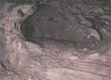
|
| Figure 21. Lava flow cascade in smaller tube, Garden Bridges area of Labyrinth Cave (see fig. 14 and map 2, pl. 1). |
Geologically, most of these short sections show only a few primary features because their floors are littered with collapse blocks, and their roofs are scarred in places where blocks have fallen out.
To a biologist, however, the Garden Bridges area is of much more interest. The small caves under natural bridges, the loose piles of talus blocks, and the countless nooks and crannies in the cave roof and walls provide refuge for many mammals. Birds are abundant, and there is a greater variety of insects and arachnids here than in most areas of the monument. Lizards and snakes, too, are attracted to this area by the abundance of food.
Botanists, too, will find a wide variety of plant life. The large range of temperature and humidity, from the cool moist air of the caves to the burning heat and desiccation on top of the lava bridges, produces microclimates to which a surprising variety of plants has adapted.
Access to the Garden Bridges is from a parking lot off the Cave Loop Road, with signs marked for both Garden Bridges and Hopkins Chocolate Cave. The trail from the parking lot forks: the left (north) fork goes to a stairway that leads into Hopkins Chocolate lava tube; the right (south) branch continues on the surface for 200 ft and loops back to the parking lot on a different course. This trail affords excellent views of many of the natural bridges and good opportunities to observe the varied flora and fauna.
One geologic curiosity in the Garden Bridges area, a well-preserved tube-in-tube (fig. 22), is easily reached from this trail. The locality is inside the remnant of a near-surface cave 120 ft long that lies in the northwesternmost line of large collapse trenches within the Garden Bridges area (labeled "tube-in-tube" on left edge of map 2, pl. 1). After lava had congealed on the floor of this distributary, a new surge of lava spilled along a gutter-like trough near its west wall. After solidifying a few inches along its top, walls, and floor, molten lava remaining in the interior of the new lava flow drained out and left behind an open culvert-like tube-in-tube. Small collapses allow one to peer into the tube-in-tube and see that it has its own lavacicles and dripstone walls. Upstream and downstream continuations of both tubes are hidden under collapse debris.

|
| Figure 22. Sketch of tube-in-tube, Garden Bridges area (see map 2, pl. 1). After the larger tube drained, a new gush of molten lava built a small tube within the older, larger tube. |
Blue Grotto Area
The area from Blue Grotto to the large collapse pits west of the Blue Grotto entrance incorporates the southern part of the Garden Bridges (map 2, pl. 1). The Blue Grotto entrance heads the only developed access trail into the complicated and extensive cave system between Garden Bridges and the two southeastern distributaries. It also provides access to the easternmost distributaries and, of course, Blue Grotto. A sign and parking lot alongside the Cave Loop Road a short distance south of the Garden Bridges parking lot marks the beginning of a trail to the Blue Grotto entrance. Underground access is provided by a stairway in a deep collapse pit in the roof of this first distributary to leave the main Labyrinth feeder; this is the longest of the distributaries (Labyrinth Distributary, map 2, pl. 1).
Part of the distributary connects the Blue Grotto entrance staircase with the large collapse 110 ft upstream. This breakdown occurred at the junction where two distributaries separated and effectively blocked the upstream continuation of the distributary. Its position can be inferred from the map. It appears that the tube holding the Blue Grotto entrance departed from its northerly flowing companion in a lava cascade. Details are not clear at the head of the passage because rubble has spread into the cave from the surface collapse and only one corner of the cascade is exposed (map 2, pl. 1, lower left corner). Downstream from the base of the lava cascade a floor jam of pahoehoe blocks spreads across the tube just upstream from the entrance stairway. Downstream from the entrance the tube widens greatly and spreads around two large pillars near its southeast wall. At the point where these lava streams reunite farther downstream another small oval collapse breaks through to the surface. Still farther downstream about 45 ft, the tube again forks. The right (northeast) branch is the continuation of the main tube; the smaller (north) branch, the Chiroptera Crossover, was left hanging 4 ft above the main tube's floor when both tubes drained. The north branch is a crossover to the Blue Grotto. At some time in its history the upper Blue Grotto tube broke through its floor into the crossover, leaving a hole 6 ft deep. The Blue Grotto derives its name from the pale-powder-blue to blue-gray color of its roof in a particular light. A thin coating of a mixture of caliche and clay left by rainwater, which seeps through the roof of the cave and evaporates, is the cause of this color.
One can climb out of the Blue Grotto tube through a surface collapse and continue along the surface via the Garden Bridges trail. Small tubes and lava blisters just below the surface are common to the north and west of this part of the Garden Bridges area; a few are large enough to show on the map. From the entrance to Hopkins Chocolate Cave, additional partly collapsed near-surface lava tubes and blisters are visible at the ground surface to the north and northeast.
Hopkins Chocolate Cave
This cave (map 2, pl. 1), discovered by E.L. Hopkins in 1892, is reached by a fork from the same trail that services the Garden Bridges area. E.L. Hopkins is credited with discovering the cave in 1892, although it may have been known previously to Native Americans. On some National Park Service maps the cave is designated as "Hopkins' Chocolate Cup." The name comes from the chocolate to yellow-brown mud, which drips through parts of the roof of the cave during the wet season.
The cave is entered by a stairway placed in a small circular roof collapse at the northwest end of the Garden Bridges area. At the base of the stairway the lava tube drops off to the northwest with a high downstream gradient, over lava cascades and falls, and joins a larger tube 380 ft downstream. Upstream from the entrance the tributary tube cannot be followed underground because of collapse pits at the north end of the Garden Bridges area. However, the distribution of these pits (see map 2, pl. 1) demonstrates that this tube and the tube that leads to Golden Dome are separate branches of one larger tube exposed only as a few natural bridges upstream from their junction. The point at which the Hopkins Chocolate tributary diverges from the Golden Dome tube is 150 ft upstream from the Hopkins Chocolate Cave entrance.
The relation of the large tube segment into which the tube containing the Hopkins Chocolate Cave debouches as a tributary to the rest of the Labyrinth Cave system is equivocal. This segment, called Hopkins Chocolate Cave Distributary on the accompanying map, extends approximately 650 ft to the north. Downstream it is filled with lava; upstream it is demolished by a surface collapse at a point only 120 ft northwest of the near-surface lava chamber that contains the tube-in-tube previously described as a geologic curiosity in the Garden Bridges area. Very likely there was an underground tube connection between these two points, although now it may be filled with lava. A collapse near this area could have blocked the flowing lava and dammed it to the roof of the large tube that contains the tube-in-tube. The small surface lava tubes and blisters that abound in this area probably broke out through cracks in the collapsing roof. Downstream from the inferred collapse, the Hopkins Chocolate Cave Distributary would have drained to where it could be replenished by lava from its tributary that contains the Hopkins Chocolate Cave entrance. The entrance tube is considered a crossover from the Golden Dome Cave Distributary into the Hopkins Chocolate Cave Distributary. Hopkins Chocolate Cave is a remnant of the northwesternmost large tube of all those in the Labyrinth system. Although we strongly favor this scenario, it has not been verified by leveling along floors throughout the Labyrinth distributaries.
Whatever the exact relations, the Hopkins Chocolate Cave Distributary has features of interest that are easily reached from the Hopkins Chocolate Cave entrance. In its lower part, downstream from the crossover (tributary) junction, wet patches on the roof and walls show excellent examples of the golden lava-tube slime for which Golden Dome Cave was named.
In the middle section of the Hopkins Chocolate Cave Distributary, the tube detours around one large and one small pillar. A floor jam of pahoehoe blocks is present above a constriction of the tube at the west tip of the upstream pillar. On the opposite side of this pillar the last trickle of lava ends in a lobe with a thin steep front.
The best development of the pale chocolate-colored mud is in the crossover, on and around the benches and small rounded pillar 175 ft downstream from the entrance.
Golden Dome Cave
Golden Dome is the name given to the arched roof of a large lava pool at the north end of the accessible part of the Golden Dome Cave Distributary (fig. 23 and map 2, pl. 1). The downstream end of this dome has collapsed and partly buried the pillar that helps to support the remainder of the dome. This collapse effectively blocks exploration of the tube farther downstream, but judging from the size of the tube and the width of the pools along it, only a small part of the total tube length is now exposed to view.

|
| Figure 23. Interior of Golden Dome Cave (see fig. 14 and map 2, pl. 1) is covered by false gold cave deposits. Ceiling height is about 10 ft at highest point. National Park Service photograph. |
The Golden Dome generally has a small amount of water dripping from, or evaporating on, its ceiling. The water droplets on the roof glisten with a golden luster, as internal reflection within the drops enhances the golden brown color of the lava-tube slime-covered clay and caliche coatings on the lavacicles and dripstone.
A marked trail leads from the parking lot at the Cave Loop Road to the Golden Dome entrance at a point 700 ft upstream from the tube's termination in the Golden Dome and 630 ft downstream from where this distributary splits off from the Hopkins Chocolate Cave crossover. One can traverse only 545 ft upstream from the Golden Dome entrance because the final 85 ft to its junction with Hopkins Chocolate Cave Crossover has been obliterated by collapse.
The Golden Dome Cave Distributary contains excellent examples of a lavacicle-covered roof, dripstone walls, and pahoehoe floors. High-lava marks along the walls testify that at times the tube was not completely filled with lava. A few lava benches record periods when the lava remained at this level until considerable solidification from the walls had occurred. Other benches made partly of collapse breccia that was smoothed over and partly bulldozed away by moving lava are present on both sides of the north branch of the lava tube that enters the Golden Dome from the west. They record collapse of roofs during the time when lava was flowing in the cave, a common occurrence in lava tubes.
Over most of its accessible course the Golden Dome Cave Distributary proceeds northward by a series of cascades interspersed with lava pools. Several parts of the complex area around the two large pillars near the north end of the tube have large roof collapses. Those who wish to see the golden reflections in the water droplets will find the same features near the north end of Hopkins Chocolate Cave, where they can be reached by a shorter and easier traverse.
Labyrinth (Area East of Garden Bridges)
Three large distributaries take off to the northeast from the east side of the Garden Bridges area (map 2, pl. 1). For the first 1,000 ft each of them seems to wander aimlessly, encroaching on its neighbors through numerous crossovers, splits around large pillars, and additional subdivision into minor distributaries and dead-end passages on different vertical levels. This part of the tube system is truly a labyrinth, and the visitor who wants to explore it is advised to carry the accompanying map and keep track of his or her exact whereabouts by observing the map at each tube junction. The easiest approach to this interesting area is through the Blue Grotto entrance, but do not take the left (north) fork, which drops over a 4-ft scarp into the head of the crossover tube leading to the Blue Grotto. Instead, continue northeast down the main distributary tube. This northeast-trending tube runs in a relatively straight line with no embellishments except a former skylight and some lava benches along the walls until it reaches a large-scale breakdown. The trail partly avoids this breakdown by entering a small bypass tube on the left (west). It then enters a maze of intersecting and branching passages that offers a wide choice of where to go and what to see. This maze is the heart of the Labyrinth—a place of blind alleys, numerous lava falls and cascades with lava pools between, hanging balconies and side tubes, and a wide variety of narrow benches and pillars. Most of the tubes within this maze contain excellent lavacicles and dripstone walls, and many are embellished with the lace-like tracery of caliche, clay, and iron oxides deposited by rainwater, which seeped through the roof and precipitated on roof and walls. The floor features range from smooth to slightly ropy pahoehoe on the lava pools to large frothy pahoehoe ropes in tubes of moderate gradient. Rare spiny aa surfaces are present below some rapids and lava falls. The roofs of many larger tubes, especially at tube junctions, have been scarred by roof collapse and in a few places by breakdowns to the surface. Most of the more interesting features are shown on map 2, plate 1. Note the position of stairs or ladders constructed by the National Park Service to assist you over lava falls and other obstacles, and to help you get from one place of interest to another. Nearly all features typical of lava tubes are contained within this compact but diverse area.
This complex network of intertwining tubes appears to suddenly become more orderly approximately 1,050 ft downstream from the Blue Grotto trail entrance. Here the anastomosing pattern virtually ceases and the tubes recombine into two major outlets—the Thunderbolt and Labyrinth Distributaries.
Thunderbolt and Labyrinth Distributaries
The western Thunderbolt Distributary (map 2, pl. 1) is monotonous compared to the wild jumble from which it emerged upstream. It has high ceilings and is easy to traverse. Large parts of its interior are intact and preserve a good display of lavacicles, dripstone, and pahoehoe floors.
The eastern Labyrinth Distributary (map 2, pl. 1) is larger, but it is littered with far more collapse breccia. Beyond the Popcorn Chamber, the passage turns north, bends sharply northeast again and promptly subdivides, and finally reunites in a complicated fashion around a cluster of five pillars. An array of lava benches clings to the tube walls and to parts of the pillars. These benches record fluctuating levels of lava, some of which persisted long enough for considerable solidification before final withdrawal to the level of the present cave floor. Withdrawal must have been abrupt and complete, as indicated by steep 1- to 5-ft-high benches and narrow balconies that remain.
The Labyrinth Distributary lies close to the surface, and numerous roof collapses are found along it. Two major breakdowns reach the surface, and much of the tube floor is littered by blocks that fell from the roof and walls.
Beyond the Labyrinth area, both the Thunderbolt and the Labyrinth Distributaries bend left and trend almost due north (map 2, pl. 1). Although the course of each is sinuous in detail, they maintain a northerly direction for more than 1,100 ft. Then, 200 ft southwest of the Thunderbolt entrance both assume an approximate N. 45° E. direction. Whereas upstream from the Thunderbolt entrance the two distributaries unite in a single tube, below this entrance about 180 ft they split into the Lava Brook, East Labyrinth, and Mushpot Caves shown on map 1, plate 1.
| <<< Previous | <<< Contents >>> | Next >>> |
bul/1673/sec2b.htm
Last Updated: 28-Mar-2006