
|
Geological Survey Bulletin 1673
Selected Caves and Lava Tube Systems in and near Lava Beds National Monument, California |
CAVES EASILY ACCESSIBLE FROM CAVE LOOP ROAD
(continued)
Hercules Leg and Juniper Caves
The Hercules Leg and Juniper Caves (map 6, pl. 2) constitute an interconnected system of near-surface lava tubes and irregular short passages. Altogether they contain 4,810 ft of passage if one counts the deviations around the many pillars, short blind tubes, and alcoves. The two major entrances to this cave system were discovered and named by J.D. Howard in 1918.
The entrance to Hercules Leg Cave is adjacent to Cave Loop Road. It is marked by a sign and parking area. The entrance to Juniper Cave, the downstream continuation of Hercules Leg Cave, is reached by a trail leading east from the Juniper parking area.
The near-surface nature of the Hercules Leg-Juniper Cave system can be seen in the shallow surface breakdowns in the caves. At most breakdowns the roof of the cave is less than 10 ft thick. Collapse blocks clutter the floors of many underground passages, and approximately a quarter of the floor of the caves is completely covered with fallen blocks. Because this slow unraveling of the roof is still in process, parts of these passages must be considered dangerous.
The Hercules Leg Cave is undoubtedly a distributary from the large feeder tubes that once conveyed molten lava from Mammoth Crater to Natural Bridge and then on through Ovis and Sentinel Caves to Indian Well and beyond. The collapse trench closest to the upstream end of Hercules Leg Cave is the one between Ovis Bridge and Ovis Cave (see map 5, pl. 2, Natural Bridge area). No direct connection between this talus-walled trench and the head of Hercules Leg Cave is visible in the field; however, an underground connection seems likely because the head of this tube is less than 100 ft from the wall of the trench, and the upper part of the Hercules Leg tube lies beneath a surface lobe of lava that spreads eastward from this area.
The actual visible underground source of the lava that once poured through Hercules Leg Cave can be reached by a traverse of 235 ft upstream (west) from the entrance. Here, at the head of this low tube, upwelling lava formed a mound as it rose from below. This mound is the top of a connector to a lower lava-filled tube, which must have split off from the feeder tubes to the west.
An unusual feature of Hercules Leg and Juniper Caves is four abrupt right-angle turns of the main lava tube (map 6, pl. 2). The lava flowed first to the east for 500-700 ft, then turned north for about the same distance then repeated this pattern. A complicated melange of pillars, short dead-end passages, and alcoves generally formed at the abrupt bends.
Features Near Entrance
The entrance to Hercules Leg Cave is a halfdome-like opening, which appears to have been a large gas blister developed under a thin-roofed part of the lava-filled tube. The north wall of this blister, plus a part of the tube roof upstream from it, has fallen in and left a pile of rubble in the opening. The main trail leads underground (left) into the downstream part of the tube.
A second and little-used trail takes off over the pile of collapse rubble and heads upstream (right). At the farthest upstream point along this part of the Hercules Leg tube, the source of the upwelling lava can be seen. Also, numerous pillars, lava cascades, and rafted blocks are present on the pahoehoe floor of this segment. There is much evidence that molten lava once filled this section to the roof. High-lava marks are common on the tube walls and on the plastered sides of the pillars. Lava cascades accentuated the flow around pillars, especially near the downstream ends.
By following the main trail downstream from the entrance, one can observe many interesting features on the way to the Barrel Skylight collapse nearly 550 ft downstream. For the first 150 ft the lava was confined to one relatively straight and high tube, but over the next 350 ft the tube splits up into an intricate network consisting of an intact west branch and segmented east branch with crossovers and numerous irregular connections. This part of the Hercules Leg Cave displays the pattern of parallel tubes with crossovers as seen in the Catacombs system, but here it is not as well developed. The similarity is closer if we restore the connection that evidently formerly existed between the collapse area at the Birdshead Lava Pool (map 6, pl. 2) and the two lava tubes 50 ft farther east. If this restoration is made, we can visualize three parallel tubes dumping lava over small cascades into one medium-sized tube draining the collected lava of all three to the north past Barrel Skylight. Downstream 160 ft from Barrel Skylight the tube makes its first right-angle bend. A floor jam of stretched and tilted pahoehoe blocks occupies the lava pool just upstream from the Unga Dunga entrance where the channel starts its northward trend. In the area just downstream from the junction of Hercules Leg Cave with Upper Juniper Cave (nearly 350 ft southwest of the Juniper Cave entrance), the similar rapid congealing of molten lava within a lava flow thinner than at Catacombs preserved an early stage in the development of the anastomosing tube pattern so typical of the upper part of Catacombs and some parts of the Labyrinth Cave system.
Features of Hercules Leg Cave between the entrance and the right-angle bends are much like the pillared area west of the entrance. High-lava marks and narrow perched lava benches indicate former highstands of the lava. Sloping floors covered with frothy pahoehoe alternate with gently sloping pools of smoother pahoehoe, much like the alternating rapids and slack areas in a mountain brook. Some roof failure occurred when lava was flowing in the tube, as indicated by the small piles of collapse breccia that were overridden with lava and by blocks rafted in frothy pahoehoe.
Middle and Lower Parts of Hercules Leg Cave
From the area at the Unga Dunga entrance, Hercules Leg Cave runs in gently sweeping curves northward for 750 ft and then makes a right-angle turn to the east for 320 ft. It then angles northeast 90 ft to its junction with Upper Juniper Cave, a tributary tube (map 6, pl. 2). In this part of its course the cave is mostly a single large tube with few complications. The right turn to the east is a rounded curve complicated only by a split of the tube around a large (80 by 45 ft) pillar.
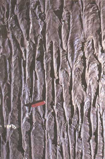
The middle and lower sections of Hercules Leg have the most intact roof; only minor amounts of collapse breccia litter its floor except at the two ends where large collapses occurred. The central parts of this area, including the two tubes which detour around the big pillar, are excellent examples of unscarred lavacicle ceilings, dripstone walls (fig. 31), and frothy pahoehoe floor adorned with rafted blocks.
|
| Figure 31. Dripstone wall in Hercules Leg Cave (see fig. 14 and map 6, pl. 2). Pocket knife for scale. |
Near the large pillar where the tube bends east is a former skylight roofed over with lava. A roof collapse has shattered and blocked the upper end of the tube that went around the east side of this large pillar. Three additional pillars are present downstream, including one 260 ft farther with a hanging tube that widens into a balcony 7-10 ft above the floor of the main passage. Many alcoves in this part of Hercules Leg show evidence of slow withdrawal of lava as the tube drained.
There are more rafted blocks in the pahoehoe floor of Hercules Leg Cave than in other tubes of the Cave Loop Road area. This probably reflects its closeness to the surface; many blocks fell into the lava stream from its thin roof during volcanism. Collapse to the surface may also have occurred at this time but was later roofed over, as at the skylight. Remnants of collapse breccia penetrated and smoothed over by lava are not abundant, however. A large floor jam of blocks occurs at the junction of Hercules Leg tube with Upper Juniper Tube.
Juniper Cave
Relation to Hercules Leg Cave
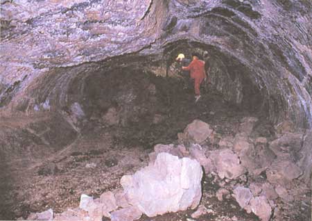
Juniper Cave is the downstream continuation of Hercules Leg Cave. After it picks up a short tributary from the south (Upper Juniper Cave), the combined system makes a sharp bend to the north, continues for 200 ft, and then makes a 90° turn east past the Juniper entrance collapse. The area where two right-angle bends closely follow one another is a jumble of large pillars between which the main tube subdivides and reunites in a network of separate strands. Large areas of roof collapse (fig. 32), including an extensive one at the Petroglyph entrance, add to the confusion. In this maze of tubes and pillars, lava cascades, pools, floor jams, irregularly shaped alcoves, and piles of collapse rubble are jumbled together. Another tributary enters Juniper Cave from the southwest, 200 ft downstream from where the main tube turns sharply east.
|
| Figure 32. Collapse blocks from tube's roof litter floor of Juniper Cave (see fig. 14 and map 6, pl. 2). National Park Service photograph. |
The tributary from the south (Upper Juniper Cave) joins Hercules Leg tube at its junction with Juniper Cave 300 ft downstream from its source and was fed from a surface lava flow. At the Swallet entrance located at the head of this tributary, a short lava gutter leads from a wide basin on the surface directly into the tube. This basin was once filled by a lava flow. After the flow had drained through this tributary tube for some time, the pooled basin lava fill at the surface broke through an obstruction on its northeast rim and continued downslope as a surface flow. This partial draining of the lava basin fed the upper Juniper tube. The final trickle of lava down the Juniper tributary tube made a low central ridge of frothy pahoehoe, which stands 1-2 ft above the older lava floor; shallow gutter-like areas formed on both sides of the ridge against each wall (see cross section on map 6, pl. 2 near upper end of tube).
The question of whether the lava flow that fed Upper Juniper Cave penetrated a breakdown in an older empty tube or was simply part of the outpouring of lava associated with the Hercules Leg tube has not been resolved. An outpouring seems more likely because the draining of both tubes appears to have occurred at the same time, as shown by evidence at the floor jam at their junction.
Floor Jam at the Junction of Hercules Leg Tube and Upper Juniper Tube
The largest floor jam of lava blocks in the Cave Loop Road area is in the Bat Whistle Room at the junction of Hercules Leg tube and Upper Juniper Tube. The jam's top in each of these two tubes is elevated a few feet above the confluence of the tube floors, but the floor jam is largest and best developed in the lower part of Hercules Leg. All of the Hercules Leg passage is not occupied, however. A 40-ft ledge of collapse breccia seals off an alcove on the north side of the mouth of Hercules Leg; this ledge formed a wall that funneled the floor jam blocks into a constriction between a large pillar and the north wall of the tube. Above this constriction the floor jam consists of smooth, integrated blocks of pahoehoe broken by deep crevasses. A few blocks of varying size from the roof were also incorporated in the jam; three of the largest rafted blocks are shown on the map (map 6, pl. 2). The floor jam is not present in the alcove behind the 40-ft ridge of collapse breccia, where pull marks reveal only slow drainage from a higher level. The collapse breccia on this floor proves that drainage of the alcove was complete before the collapse. As noted earlier, however, the collapse breccia is older than the pahoehoe of the floor jam, which was funneled south by this collapse ridge.
Below this constriction the nature of the lava floor jam changes. The blocks are much smaller and have jostled together into a lobe of loose rubble. Many are frothy, spiny, highly inflated pahoehoe. Where this lobe advanced against the pillar on the south and the tube wall to the north, floor blocks near the walls are definitely overridden and shoved aside. This constricted part of the lobe has a high gradient; it is essentially a cascade of jumbled blocks, which may have moved catastrophically like a rockfall or rock avalanche. At the foot of this cascade the lobe rolled out over the flat surface of a pahoehoe pool and then collided with a wall of collapsed blocks at the narrow upper entrance of a branch from the tube around another pillar (map 6, pl. 2). These collapsed blocks may have fallen from the roof and walls between the two adjacent pillars at the same time the floor avalanche advanced.
The avalanche caused unusual changes when it crossed the pahoehoe. Evidently the lava pool had a solid crust above a molten interior because its surface bowed beneath the weight of the avalanche debris and collapsed roof blocks. The displaced lava was squeezed farther downstream, where its crust lifted into a pressure ridge. Part of this uplift also swelled into a rounded blister with radiating cracks in its top.
Whether the rock avalanche and the roof collapse at its toe were triggered by an earthquake, which struck the area after most, but not all, the lava in the tube had drained, is a theory that might explain the time relations within this small area. However, no concrete evidence substantiates this theory. The quake theory does support the observation that although the lava throughout the Hercules Leg-Juniper Cave system contains a large number of rafted roof blocks, almost no large areas exist where collapse breccia was overridden by lava.
| <<< Previous | <<< Contents >>> | Next >>> |
bul/1673/sec2f.htm
Last Updated: 28-Mar-2006