
|
Geological Survey Bulletin 1673
Selected Caves and Lava Tube Systems in and near Lava Beds National Monument, California |
CAVES EASILY ACCESSIBLE FROM CAVE LOOP ROAD
(continued)
Natural Bridge Area
Large, spectacular collapse trenches are present in the area where Cave Loop Road crosses the Mammoth Crater-Post Office Cave line of breakdowns over the feature named the Natural Bridge (map 5, pl. 2). This bridge also marks the point where the feeder tubes from Mammoth Crater began to subdivide into the numerous distributaries that built the sloping plain and the numerous tubes of the Cave Loop Road area (fig. 14). The Paradise Alleys-Catacombs Cave system and the Hercules Leg-Juniper Cave system have their upstream beginnings here. Four short near-surface lava-tube caves—Sunshine, Battered Sherman, Juniper Pole, and Gail—are within this area, as are numerous small spillover lobes of lava, small collapse basins, and miniature breakdowns, and lava trenches.
Because the deep collapse trenches are large features, the scale chosen for the Natural Bridge area map is reduced more than that of the other maps. To clarify the spatial relations between the trenches and nearby cave systems, the area around Ovis Cave, the head of Paradise Alleys, and the part of Hercules Leg Cave upstream from its entrance have been replotted on map 5, plate 2 at a larger scale.
Short remnants of two large feeder tubes have survived nearly intact beneath Natural Bridge. One can walk through two strands of the upper tube (separated by a pillar) and visit a short section of the lower tube through crawlholes. The easiest and most interesting way to visit one of these large tubes, however, is to take the trail through Ovis Cave. Ovis Cave's position and the trails at its downstream end are shown on map 5, plate 2. Ovis Cave, the tube under Ovis Bridge, and the upper tube beneath Natural Bridge are all remnants of the same large lava tube.
Battered Sherman Cave and Sunshine Arch are located along the lava channel leading to Sunshine Cave.
Large Collapse Trenches
The most spectacular features of the Natural Bridge area are the deep collapse trenches. However, the amount of space within the central part of such a trench, as between Natural and Ovis Bridges, presents an interesting puzzle. This trench definitely is too deep and voluminous to be ascribed to a roof fall in the upstream continuation of the lava tube in Ovis Cave. How then is the additional room in this trench to be explained? There are three possibilities. (1) The tube increased in size upstream, due both to a thinning of the roof and to a deepening of the channel, (2) two or three tubes were superposed one above the other, and all of them have collapsed together, or (3) collapse began while lava was actively flowing through the tube, and the fallen blocks were rafted down the tube before volcanism ceased.
From evidence downstream (map 4, pl. 2, map 15, pl. 5, and map 18, pl. 6, and "Ovis," "Post Office," and "Crystal Cave" sections) it is apparent that multiple collapse is the most probable explanation. In fact, by superposing the map of Ovis Cave on that of Crystal Cave one notes that the deepest tube exposed in Crystal Cave lies demolished beneath the deepest section of the trench between Ovis Bridge and Ovis Cave. The second theory sufficiently explains the added space in the deep trench between Natural Bridge and Ovis Bridge. Consistent with this explanation, the profile of the talus on the walls of this trench shows a narrow medial trough with steep cliff sides giving way to gentle talus slopes higher on the walls—the profile to be expected because the lower tube in Crystal Cave is smaller than the one that formed Ovis Cave.
The very large collapse trench that lies upstream from the Natural Bridge, however, contains evidence of a much more complex history that may involve all three processes. This trench shows clear evidence of having developed from an earlier collapse after which molten lava lay ponded in a wide lava lake or sluggish stream open to the sky during at least some major periods of volcanism. Today the rock rim of this trench is a cliff ranging from a few feet to 45 ft in height. From the base of the cliff a talus slope of loose blocks descends to the deep central part of the trench, which is at the projected elevation of the two large superposed lava tubes beneath Natural Bridge.
The deepest hole within this collapse trench is at the trench's extreme northeast corner, directly beneath the upstream entrance to the caves beneath Natural Bridge. Here, a collapse that extends through the upper tube and into the lower tube beneath Natural Bridge has formed a pit over 50 ft deep. This pit is bordered on the southwest by a steep ridge of talus that forms a berm across the head of the trench and divides the main part of the trench from the deep hole just upstream from Natural Bridge. Only near this cave entrance can any clearcut relation be seen between the trench and the passages of the lava tubes. It is clear that both the upper and the lower lava tubes exposed beneath Natural Bridge extended upstream into the northwestern part of the area now occupied by the deep collapse trench. Yet a simple calculation will show that the volume of the collapse trench is at least three times greater than the space required to completely fill lava tubes the size of those beneath Natural Bridge, which are almost certainly the upstream continuations of Ovis Cave and the lower tube in Crystal Cave. No remnants of other tubes that might help with this space problem are known. If they ever did exist, which seems unlikely, they are hidden in the talus of the collapse trench.
Other interpretations of the history of this trench can be inferred from a study of the rock rims along its borders. First we note that the highest elevations around the trench are on these rims; the sagebrush-covered ground on both sides slopes away from the trench, not toward it. As indicated on the map, molten lava spilled over the trench rim as small lobes in many places. Some lobes escaped over the rim through low areas along the northwest side and then coursed northward down the slope. A larger lobe, which contains Sunshine Cave, spread beyond the area of the map. The Sunshine Channel, at the head of this cave, and its connection with the trench, is shown on an inset of the Natural Bridge map (map 5, pl. 2); its passages are described in the section "Battered Sherman Cave and Sunshine Arch." The Sunshine Channel is partly lava gutter and partly small lava tube; farther downstream it is still roofed over to form Battered Sherman Cave; a miniature natural bridge, Sunshine Arch; and the upper part of Sunshine Cave. Note that where the channel leaves the big collapse trench, backflow features developed. Thus it was a lowering of the lava lake within the large collapse trench that stopped the filling of Sunshine tube and allowed it to drain and survive as an open cave.
Lava-Tube Caves in the Natural Bridge Area
Ovis Cave, Paradise Alleys, and Hercules Leg Cave all have their upstream entrances within the Natural Bridge area. Ovis Cave and Paradise Alleys are shown on map 4, plate 2, Hercules Leg and Juniper Caves are shown on map 6, plate 2. Caves shown on map 5 (pl. 2) of the Natural Bridge area include: (1) a complex of two large lava tubes and two small lava tubes beneath Natural Bridge; (2) Gail Cave, a small lava tube with two collapse basins strung along it, which can be traced for 400 ft northeast after branching from the upper tube beneath Natural Bridge; (3) Juniper Pole Cave, south of the embayment at the southeast corner of the large collapse trench upstream from Natural Bridge; (4) Sunshine Cave, Battered Sherman Cave, and Sunshine Arch, northwest of Natural Bridge; and (5) Duffys Old Still Well and Prohibition Cave, upstream from the segment of deep collapse trench.
Caves Beneath Natural Bridge
The caves beneath Natural Bridge are remnants of four different lava tubes, each of a different size and at a different elevation; all these caves can be entered from the large passage beneath Natural Bridge.
At the downstream (northeast) side of Natural Bridge is a large arched cavern 12 ft high and 40 ft wide. It quickly narrows to half this width, because a slide of loose blocks spilled onto the floor from a collapse of part of the southeast roof and wall. Farther upstream 80 ft, however, the tube suddenly widens on both walls, subdivides around a 75-ft-long pillar, and then reunites at the pillar's upper end. In another 20 ft the single tube, now 20 ft high and 45 ft wide, was demolished by the northeast end of the deep collapse trench, which forms the southwest side of Natural Bridge. This tube, labeled "upper tube" on map 5, plate 2, is almost certainly the upstream continuation of the large tube that forms Ovis Cave. Another remnant of it forms the opening beneath Ovis Bridge.
Beneath the upper tube is another large tube—the Hummingbird Flyway. It does not split around the pillar like the upper tube but continues upstream beneath the area adjacent to the pillar (see the cross section of Natural Bridge on map 5, pl. 2). Only about 60 ft of this lower tube is accessible; the rest of it (southeast of the pillar) was demolished by collapse of the upper tube's floor. Along part of this collapse, however, the southeast wall of the lower tube can be traced, curving up in places beneath an overhanging ledge formed by the broken floor of the upper tube. In this stretch the Flyway is more than half filled with collapse debris.
Two crawlways and a pit permit entry into the relatively undamaged part of the lower Hummingbird Flyway tube. One crawlway is located in the upper tube 15 ft southwest from the downstream edge of Natural Bridge, at the northeast margin of the slide that spills out from the southeast wall. The second crawlway is through a maze of huge collapse blocks where the southeast wall of the upper tube swings out around the pillar. It is near the northeast corner of the collapse that dropped part of the floor of the upper tube into the lower tube. The pit is located along the southwest wall of the collapse at its upstream end (see positions of these crawlways and pit on map 5, pl. 2). The remnant of the lower tube that can be traversed between these crawlholes is an oval-shaped tube, 55 ft long, 25 ft wide, and 11 ft high.
An upstream extension of this lower tube might be opened from beneath the upstream side of Natural Bridge. A pile of large collapse blocks lies at the point where the broken ledge of the upper-tube floor intersects and crosses over the southeast wall of the Hummingbird Flyway, roughly 20 ft beneath the upstream side of Natural Bridge. We were able to crawl down among these tumbled blocks to a level equivalent to the floor of the lower tube, but we did not locate an entrance into a cave upstream from them. There is no question, however, that both of these large tubes extended farther upstream before roof collapse demolished the upstream side of Natural Bridge.
Two small tubes can also be explored from the upper tube beneath Natural Bridge: a small tributary, already mentioned, that enters the upper tube from the west by an 18-ft lava cascade and Gail Cave. The tributary tube and cascade is traversable for 90 ft upstream from where it debouches onto the floor of the upper tube. It is blocked by a roof collapse near the point where it was fed from an overspill of the lava lake.
This traverse demonstrates that the lava-tube passages beneath Natural Bridge are much more complicated than the usual simple tunnel beneath most natural bridges of lava-tube origin. These complexities caused J.D. Howard to name it "Compound Bridge," a name that is no longer used.
Gail Cave
Gail Cave, informally named after the wife of one of the assistants on this project, is a shallow and broad lava tube, which can be traced for 400 ft to the northeast. It lies above the upper tube beneath Natural Bridge, and its course is interrupted by two shallow collapse basins (see map 5, pl. 2). The floor of Gail Cave, where it leaves the upper tube, is a lava pond. Apparently lava ponded in both the upper tube and in Gail Cave when collapse occurred. This pond extends into Gail Cave for 20 ft and spreads out around the edges of the first of the two collapse basins. It is advisable not to try to force a passage through the tumbled blocks around the margin of this basin. Instead, return to the surface via the upper tube beneath Natural Bridge and walk southeast along Cave Loop Road to the second collapse basin. In this second small collapse basin is a good entrance into the 200-ft section of the cave that joins the two basins. This part of Gail Cave is very different from the pooled lava floor at the head of the tube. The most interesting feature is the wavy and irregular coarse ropy surface of the lava that fills half the tube and makes it difficult to traverse. This final lobe of lava must have been very viscous and barely able to creep forward as it congealed. A remnant of an earlier stand of lava, perhaps a balcony that was broken up and mostly carried away, is present near the middle of the tube along the southeast wall. A 4-ft-high tongue of lava—evidently a backflow lobe from the northeast basin—is located just in side the entrance to Gail Cave (map 5, pl. 2).
The difference in surface roughness downstream and upstream from the first collapse basin might have been caused by the basin collapse. If a catastrophic collapse of the roof of this basin occurred while lava was flowing within the distributary, it might have pooled the lava upstream but at the same time violently forced half-congealed lava into the downstream part of the tube. This may have been a sufficient disturbance to propel the partly crusted lava down stream into irregular waves and coarse ropy folds that promptly hardened into rock.
Juniper Pole Cave
Juniper Pole Cave is named for a 9-ft-long crude ladder fashioned from a juniper tree, thrust years ago into the small middle entrance to provide access to the cave. Juniper Pole is a relatively simple cave, a small tube split into three distributaries. The enlarged map (on map 5, pl. 2) of this cave tells its own story. The surface flow of lava that contains the cave emerged from the south wall of the shallow basin at the head of the deep collapse trench. It cascaded down a steep slope for 100 ft, turned east following the underlying topography, decreased in gradient, pooled, and split northeastward into distributaries at the point where it lost gradient. Where the subdivision occurred, the floor of this wide area is deeply mantled by collapse blocks from the roof. In many places the piles of loose blocks extend nearly to the ceiling, and, therefore, travel is difficult and hazardous. In the middle of this area there is an 8-ft drop in the collapse rubble. It probably hides a cataract or low lava fall in the floor. The tube, which debouches into this chamber farther upstream, is blocked by peeling linings as well as a 7-ft lava fall at its head.
In contrast with these breakdown areas, the southern distributary of Juniper Pole Cave has a strong roof and an excellent display of pahoehoe, lavacicles, dripstone, and rafted blocks. The ceiling height, however, is so low that one must stoop or crawl to examine these features.
Sunshine Cave
Sunshine Cave is the longest and most interesting of the small tubes in the Natural Bridge area. J.D. Howard explored and named it in January 1921. The entrance to Sunshine Cave is indicated by a sign at a parking lot beside Cave Loop Road just before you reach Natural Bridge.
The topography of the surface shows that the upper part of Sunshine Cave, Battered Sherman Cave, Sunshine Arch, and Sunshine channel upstream from these caves occupy the central axis along a 600-ft-long lobe of lava that spilled over from the former lava lake in the large breakdown just upstream from Natural Bridge (map 5, pl. 2). The part of Sunshine tube that is contained in this lobe could not have extended more than 250 ft. This figure, however, is no criterion of the true length of the Sunshine tube, nor of the total volume of lava that passed through it. The reason becomes clear only after we examine that part of the tube 220 ft downstream from the entrance, where it makes an abrupt turn to the northeast. At this locality the weight of the lava in the Sunshine lava lobe forced a breakdown (or else the lava discovered a roof collapse) into an older open tube formed in a deeper flow. A large but unknown volume of lava tumbled into this lower distributary and continued to flow until ultimately all but 200 ft of the upstream part of this lower tube was filled to its roof, and thus access was terminated to the northeast.
Collapse blocks from the surface clutter the Sunshine entrance, but otherwise the first 200 ft of the cave shows typical lava-tube features. The roof is decorated with lavacicles that bend and flow into dripstone as the roof rounds onto the walls. Near the entrance a prominent narrow bench is present on both walls 12 ft above the floor. A less conspicuous high-lava mark is 7 ft above the floor. A 5-ft cascade is located 50 ft from the entrance, and a second 3-ft cascade is another 120 ft farther downstream. Between these two cascades is a 55-ft stretch of floor where the partly solidified pahoehoe broke up into a block jam. Final draining below the cascades left a cave floor of frothy pahoehoe.
At 210 ft downstream from the entrance, the Sunshine tube turns abruptly to the right (northeast) and just beyond the turn many of its physical features change in appearance (map 5, pl. 2). In this area is where flowing lava discovered or else forced a breakthrough into an underlying open lava tube. The exact place where the breakthrough occurred is difficult to pinpoint, because once a spill into a lower tube is effected, further collapse enlarges and spreads the area of breakdown. Such spreading of the collapse clearly did occur in the Sunshine Cave, but it is likely that the first collapse may still be preserved in the round pit crossed by the catwalk 20 ft beyond the abrupt bend to the right, 230 ft from the entrance. Inspect the edge of this pit and note that lava poured into it from all sides. Unfortunately, collapse filling obscures the junction of the lower part of the pit with the underlying tube. Clearly this hole served to transmit lava to the lower level, but it may not have been the site of the first collapse.
Additional collapses in the Sunshine tube occurred where the floor of the upper tube disappears piecemeal into the lower tube 90 ft farther downstream, at the point where the trail descends into the lower level via a short stairway. Most of the collapse debris was carried away by the flowing lava, but some may remain buried beneath the lava on the floor. Indeed, the stairway does not reach the original floor of the lower level, which lies beneath ponded lava. Such ponding may have been caused by a small dam of collapse debris.
Another 15 ft downstream the congealed Sunshine lava flood subdivided around a pillar and cascaded for a vertical distance of nearly 8 ft before reuniting on the downstream side of the pillar. Was there a jam of collapsed blocks against the upstream end of this pillar that created the 15-ft-long pond? It seems likely, for several rafted blocks are frozen into the lava surface just upstream from the pillar, and downstream from the cascades many rafted blocks were being carried away when the lava solidified. One large block is shown on the map and is found on the eastern margin of the lava stream where it rounds the next bend. A post-lava collapse that broke through above ground nearly closes the tube in an area 50 ft downstream from the catwalk. At the Mouse Hole, 50 ft farther and a total of 465 ft downstream from the entrance, the lava pooled until its floor was only 6 in. from the roof of the tube.
Battered Sherman Cave and Sunshine Arch
As lava drained out of the channel, the roof of the short upstream extension of Sunshine Cave partially collapsed, a process that formed Battered Sherman Cave and Sunshine Arch. The entrance to Battered Sherman Cave is between collapsed blocks at the downstream end of the cave. Post-lava-flow breakdown has obliterated virtually all of the original linings of the cave; indeed nowhere does the ceiling height exceed 4 ft. A chaos of blocks has to be traversed along its 38-ft length to reach the collapse area at its upstream end. A battered Sherman live animal trap was found in the cave when it was explored in 1988, hence its name.
Sunshine Arch is located between Battered Sherman Cave and the entrance collapse of Sunshine Cave proper. It is a very small remnant of the roofed tube upstream from Sunshine Cave. The 7-ft diameter and 5-ft long arch has undergone extensive unraveling and nothing remains of its original interior surfaces. A similar arch is shown in figure 30.
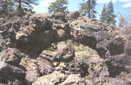
|
| Figure 30. Arch-shaped natural bridge of lava is similar to that at Sunshine Arch. This arch was formed by collapse of lava tube carrying basalt of Giant Crater on south flank of Medicine Lake volcano (see fig. 1). |
Another spillover lobe immediately east of the Sunshine Channel also formed a lava gutter, became roofed over, and, after a few right-angle turns, tumbled into the upper tube beneath Natural Bridge in an 18-ft cascade. One cannot walk through this connection today because access is denied by a roof collapse at the point where the gutter went underground.
Evidently at the time when lava was feeding into these overspills and small distributary tubes the site of most of the present deep collapse trench must have been occupied by a large lava lake, perhaps mostly crusted over but including parts where molten lava was open to the sky. Evidence of the lava lake can be seen near the head of the trench. Two spillover lobes are shown on the map just to the east of the shallow basin that forms a "bay" at the southern end of the collapse trench. Before the formation of these small lobes, a much larger flow of lava evidently escaped from this bay in the side of the trench. This flow contained lava tubes within its core. Most of these tubes filled with lava, but the upper parts of some still remain open as in the case of Juniper Pole Cave, a network of subdividing near-surface distributary tubes. Downstream, all tubes are filled with congealed lava.
One of the more interesting features formed by overspills from the large lava lake is a small flat-topped ridge known as The Wall. It borders the south side of the wide bulge in the middle of the trench. Two small collapse basins on the south side of The Wall indicate that another flow of lava, comparable to the one that contained the Juniper Pole Cave, spilled over the rim of the trench at this point. This lava flow must have also developed lava tubes, and the upper parts of these tubes collapsed to form the two small basins. The Wall itself developed from inch-thick sheets of lava continually deposited and cooled from slight spillovers of the oscillating lava lake level. This thick and sturdy rock wall, 4-15 ft thick and 5-8 ft high along its south side, consists of dozens of thin lava sheets stacked on top of one another. Some layers are only small rod-like trickles instead of sheets, as seen on the outside of The Wall. The interior side of The Wall is a caved surface formed when the lava lake dropped to a lower level and drained out. It shows broken edges of sheets, smoothed over in places by a coating of lava plaster stuck against them as the molten lava lowered.
What caused the lava lake in the first place? And how did it disappear and its site become covered with talus? Judging by what we can see of the continuation of the major lava tubes downstream in such places as Ovis, Crystal, Sentinel, and Post Office Caves, it seems many fillings and drainings of the lava lake occurred as different eruptions rose to a climax and then waned. Lava also backed up into the tubes when roof collapse partly or completely blocked its flow (see the maps of Crystal (map 18, pl. 6), Skull (map 12, pl. 4), and Post Office (map 15, pl. 5) Caves). The lava tubes that formed within the site of this particular stretch of trench undoubtedly have repeatedly lost parts of their walls and roofs as molten lava coursed through them, for in no other way can we account for the size of the present trench except by the rafting of both old tumbled and newly congealed thin roof blocks and wall linings down the tube. After collapse and rafting of this rock, intermittent blockage of the tubes downstream created the rise of a lava lake until it overflowed. Such a sequence of events was probably repeated many times during the buildup of the lava plain that slopes away on both sides of this major trench. This plain also includes the northeast slope honeycombed with the near-surface lava tubes upon which Cave Loop Road is built.
Within the area shown on the Natural Bridge map (map 5, pl. 2), two more breakdowns upstream from the deep collapse trench give additional clues to the position of the line of major lava tubes underground. One is a deep trench, 80 ft long and about 50 ft wide. The upstream side is breached by a shallow draw 50 ft long. From the south edge of this draw a broad spillover lobe of lava escaped to the south but narrowed to a point and congealed within 100 ft.
Another 125 ft upstream is a deep pit called Duffys Old Still Well that is 85 ft long and 25 ft wide at the surface but with vertical to overhanging walls in its deeper parts. The collapse debris on its floor is only a few feet thick, and an open lava tube extends both upstream and downstream from the bottom of the pit. The small pile of collapse debris on the floor of this pit accounts for less than 3 percent of the missing parts removed from the basalt units seen on the pit's walls. Evidently, the missing materials were rafted down the tube. This deep vertical pit is very similar to one located east of Post Office Cave along the same line of collapse trenches. We named this pit Duffys Old Still Well because in prohibition days a still was concealed beneath the overhang produced by the egress tube at the north corner of the well. This pit has been shown as "Duffys Well" on old maps of the area.
Prohibition Cave
Southwest 100 ft from Duffys Old Still Well is the upstream continuation of the collapse trench. At the trench's downstream end is a small preserved segment of lava tube. Two small entrances lead down into Prohibition Cave through collapse rubble. Virtually no interior surfaces remain in the cave's single chamber because the walls and ceiling have unraveled extensively and covered the floor with collapse rubble. Collapse blocks prevent any travel beyond the first 35 ft down the tube toward the small cave at Duffys Old Still Well. Prohibition Cave is a continuation of the main tube that extends both upstream and downstream from Duffys Old Still Well, and its name is derived from the dashed hopes of explorers to find an easier way into Duffys Old Still Well.
| <<< Previous | <<< Contents >>> | Next >>> |
bul/1673/sec2e.htm
Last Updated: 28-Mar-2006