
|
Geological Survey Bulletin 1673
Selected Caves and Lava Tube Systems in and near Lava Beds National Monument, California |
CAVES EASILY ACCESSIBLE FROM CAVE LOOP ROAD
(continued)
Ovis Cave and Paradise Alleys
Map 4, plate 2, of Ovis Cave and Paradise Alleys, overlaps map 3, plate 1 in the Catacombs Basin area and extends map 3 to the southwest. Paradise Alleys are the upstream continuation of the Catacombs lava-tube system beyond the lava lake that filled the Catacombs Basin. The near-surface Paradise Alleys lava tubes were fed from the large tube of which Ovis Cave and Ovis Bridge are uncollapsed remnants. A large distributary from this feeder once ran northeast just upstream from the head of Ovis Cave but is now represented only by a broad shallow collapse basin that extends N. 65° E. for 125 ft. From the north wall of this collapsed distributary, three near-surface lava tubes extend north. Another eastward-extending lava tube joins them from just under the roof of the south end of Ovis Cave. Beyond Ovis Cave these tubes trend northeastward and form the network of passages that makes up the Paradise Alleys (see maps 4 and 5, pl. 2).
Ovis Cave and Paradise Alleys are difficult to traverse because of partial roof collapse. This collapse has obliterated most of the ceiling features except in some of the smaller tubes of Paradise Alleys. For the student of lava-tube hydraulics, this area furnishes a fascinating look at the anatomy of a major feeder tube and its distributaries.
Ovis Cave
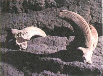
Apparently, E.L. Hopkins was the first white visitor to Ovis Cave (map 4, pl. 2) in the 1890's. He reported finding 36 Bighorn sheep skulls in the cave (fig. 27). J.D. Howard explored this area in 1918 and named the cave Ovis, the Latin word for sheep, although by this time Bighorn (Ovis canadensis) had disappeared in this part of the West.
|
| Figure 27. Skulls of Bighorn sheep were found in Ovis Cave (see fig. 14 and map 4, pl. 2), giving the cave its name. |
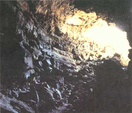
Ovis Cave resembles a huge railroad tunnel 200 ft long, 20-40 ft high, and 30-50 ft wide (fig. 28). When it was formed, its floor was 60 ft or more below the surface. Angular blocks that tumbled from the ceiling buried its floor beneath rubble. Original ceiling features such as lavacicles can be found only on the fallen blocks. Patches of accretionary wall lining, however, have remained intact over half of the original walls. Seven narrow lava balconies indicate that lava flowed at each of these levels long enough to solidify and leave easily traceable ledges. Many of these nearly horizontal ledges resemble continuations of flow layers. This tube developed within a lava pile composed of different flow layers. Contacts between these layers, as seen in the walls of the tube, were plastered over by lava that later drained away.
|
| Figure 28. Entrance of Ovis Cave (see fig. 14 and map 4, pl. 2) as seen from inside this large feeder tube. Person at left for scale. |
Deep collapse trenches terminate Ovis Cave at either end. They mark positions along a system of large lava tubes at least 6 mi long, which extends from Mammoth Crater (fig. 4) to beyond Post Office Cave. This system of tubes may extend to Craig Cave and beyond.
Paradise Alleys
The intertwining tubes of the Paradise Alleys can, for convenience, be divided into three levels (map 4, pl. 2), although most of the upper level is only a partially developed drained balcony within the middle level.
Lower Level
High on the east wall of Ovis Cave, just below the roof and near the collapse that terminates the cave's extension to the south, a small lava tube branches off. This small eastern distributary hangs 25 ft above the rubble-covered floor of Ovis Cave and is the head of the lowest and probably oldest level in the Paradise Alleys distributary system. Within 20 ft of its beginning, however, the floor of this tube is left hanging as a balcony on the walls of a second and slightly larger tube. This tube trends northeast from its head on the north wall of an east-trending shallow basin, which branches from the main collapse trench to a point 40 ft east of the head of Ovis Cave (map 4, pl. 2). After they join, both the balcony and the floor of the tube below it turn to the northeast in a series of lava cascades. They pass completely beneath the much wider middle level of Paradise Alleys. The middle level originated and flowed north from the east end of the shallow collapse basin.
Most of the accessible length of the lower-level tube shows lavacicles and dripstone walls whereas its original pahoehoe floor is littered with collapse blocks. Downstream 70 ft below this passage's entrance, a 6-ft-diameter rafted block half-closes the tube. The upper surface of this rafted block is decorated by many broken and distorted lavacicles and by lava, which coated it during its transit along the tube. Downstream 180 ft farther from the entrance is a hole in the left (west) wall of the lower level tube, 10 ft above its floor, which provides ladder access to the middle level of Paradise Alleys. From here visitors can leave via the Paradise Alleys entrance, another 80 ft downstream. Downstream 45 ft from the foot of the ladder, the lower-level tube is blocked to further entry by a roof collapse.
Middle Level
Of these three tubes, the 40-ft-wide middle-level passage is the largest and transmitted the most lava. Only 240 ft of its length is accessible because its continuation downstream below the Paradise Alleys entrance is completely buried by collapse debris. Unquestionably it extended beneath the partly collapsed skylight just to the east, and from there it extended beneath the upper level to a subterranean junction with the lava lake that once filled the Catacombs Basin.
Upper Level
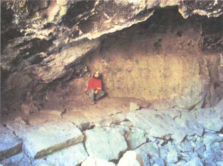
The upper level of the Paradise Alleys tubes begins as a balcony hanging on the east wall of the middle level tube 80 ft upstream from the Paradise Alleys entrance. Here, its rounded upstream end can be entered by climbing a 5-ft ladder. Whereas the middle-level tube bends almost 90° at the entrance to Paradise Alleys, this adjacent upper-level tube continues straight as a smaller tube. From the entrance alcove one can walk downstream for 75 ft to where the tube emerges into a former skylight whose walls have been greatly enlarged by late-stage collapse. As the upper level leaves this skylight downstream, however, the tube changes drastically in character. It becomes larger, 25-40 ft wide, and much of it—especially to the northeast—appears to be filled almost to the roof with lava. Moreover, much of its pooled lava floor has collapsed (fig. 29) into a lower tube. This is best shown by a traverse upstream beginning from its northeast end, where lava fill reaches the roof and blocks access to the northeast; here a jumbled mass of floor blocks lies just below small balcony remnants still attached to the walls. On the left (northwest) wall a huge 30-ft slab of the balcony is detached from the wall and now lies on its side atop fractured blocks of the subsided floor. Another 80 ft upstream where the ceiling is lower, a remnant of balcony crosses the tube and thus forms a bridge over the broken-up floor jam of balcony blocks.
|
| Figure 29. Original pahoehoe floor of upper level Paradise Alleys tube (see fig. 14 and map 4, pl. 2) collapsed when molten lava withdrew underneath chilled surface. |
Upstream 95 ft—just southwest of a collapse to the surface—the floor of the upper level has tumbled so completely that its former position is recognized only by a few small balcony remnants 4-6 ft above the jam of collapsed balcony rubble that forms the present floor of the cave. The explanation for these relations is clear. These floor jams and balcony remnants show that the upper level, from the former skylight northeastward, is an unstable fill formed within the middle level. After its 90° bend, the middle level rejoins the small upper tube at the former skylight. What we see from the skylight northeastward is the record of a high-lava fill in the middle level, which persisted at this height long enough for its top to completely solidify from wall to wall. After a solid crust less than a few feet thick had formed, the molten lava beneath continued downstream and ultimately drained to a level 5 ft or more below its former stand. This allowed part of the crusted-over floor to subside and thereby form a jam of balcony blocks in parts of the tube and a bridge in a narrow part close to the roof. The balcony level also survived completely intact in the small upper tube, which continued straight. Remnants of this balcony, changing in places to sloping alcoves, also occur along the middle level all the way to its head in the shallow collapse basin.
In summary, this shallow collapse basin and the middle level of Paradise Alleys constitute the main distributary that supplied lava to the Catacombs system of lava tubes. The lower and upper levels, the balcony, and the floor jams are interesting supplementary records of fluctuation in the height of the lava in both the Paradise Alleys and in the Catacombs Cave.
Former Skylight
The former skylight just east of the entrance to Paradise Alleys provides further evidence of a high-level stand of the molten lava pouring through the Paradise Alleys tubes. The lava overflowed and spilled out to the north and east onto the surface through the skylight. The more prominent spillovers are indicated by dashed lines (enclosing arrows that indicate the direction of flow) on map 4, plate 2. Spillovers from the last high-stand of Catacombs Basin lava lake are similarly shown.
| <<< Previous | <<< Contents >>> | Next >>> |
bul/1673/sec2d.htm
Last Updated: 28-Mar-2006