
|
Geological Survey Bulletin 1673
Selected Caves and Lava Tube Systems in and near Lava Beds National Monument, California |
OTHER CAVES IN OR NEAR THE MONUMENT
(continued)
Skull Cave
Skull Cave (map 12, pl. 4) was first visited by modern explorers in 1898 following E.L. Hopkins' sighting of the long collapse trench at the head of the cave from the top of Crescent Butte. On investigation he found on the lower level, partly embedded in ice, two human skeletons and abundant bones of antelope, bighorn sheep, and mountain goats. A broken log also lay on the ice. Apparently two Indians had attempted to lower the log to serve as a ladder but let it slip, and they were swept off the balcony to their deaths.
Skull Cave is located at the end of a well-marked paved road. It is a remnant of two large lava tubes superposed upon one another. Like Kirk Whites and Beaconlight it is on the line of collapse trenches and caves, which skirt the south side of Schonchin Butte. The upper tube has suffered so much collapse of its roof, floor, and walls that most details of its original form are lost. The lower tube, however, retains many of its primary features despite large collapses through its roof and extensive slides through its walls.
Two balconies can be seen from the stairs built to access the downstream part of the lower tube. These might be considered two additional separate levels; however, because the upper balcony ends downstream in a blunt semicircular wall, and the lower balcony ends 60 ft upstream by filling to its roof, they are more appropriately considered local balconies marking periods during which draining of the eastern part of the lower tube halted. This downstream part of the lower level is nearly cut off from a large upstream chamber by a huge pile of collapse blocks (see longitudinal section on map 12, pl. 4). Passage between the two chambers of the lower level is through a narrow crawlspace up and around the northeast side of this roof-collapse pile. The upstream chamber has been nicknamed "Boneless Cavern" by disappointed spelunkers who had hoped to find another rich store of animal bones after they negotiated the narrow crawl. Neither of the two balconies that are so conspicuous in the lower level are present in the Boneless Cavern.
The complexities of Skull Cave make it a prime example for studying a large feeder-tube system. If we consider the two levels and balconies and count the overlaps where they are superposed, over 1,000 ft of linear passage is available for study and exploration. These passages record some information, but they also provide some unsolved puzzles concerning the origin and hydraulics of the large feeder tubes that transmitted vast quantities of lava from vents for the basalt of Mammoth Crater to the lowlands bordering Tule Lake (a distance of approximately 15 mi).
Upper Level
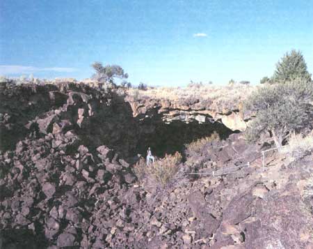
The entrance into Skull Cave (fig. 47) is at the east end of an impressive collapse trench, 460 ft long and 100 ft wide. The upper level resembles a huge tunnel, 60-80 ft wide and 30-65 ft high. At a point 480 ft east of the entrance the upper tube ends abruptly at a semicircular wall. Here, lava in the upper tube found an opening into a lower level. A small remnant of the lava that poured into this connector survives as a frozen lava fall. The lava cascade marking the top of this fall can be seen from the base of the first (upper) stairs on the trail to the south wall of the tunnel, and then it curves east against the south wall of the tube for 25 ft. The north half of the lava fall remnant is completely buried beneath the debris of a later roof collapse.
|
| Figure 47. Collapse trench and entrance to Skull Cave (see fig. 4 and map 12, pl. 4), one of the largest caves in Lava Beds National Monument. |
The only locality where the original floor of the upper level can be seen is at the top of the lava fall, in the southwest corner of the upper level. Upstream from here to the entrance, the tube is floored by huge fallen blocks caved from its roof. Eventually, the entire roof of Skull Cave will collapse and extend the large collapse trench.
After the lava drained from the cave, many additional collapses occurred in both roof and floor of the upper level. Some parts of the present floor—an irregular jumble of fallen blocks—are lower than the floor at the top of the aforementioned lava fall. This can only mean that large sections of the floor upstream from the lava fall tumbled into the tube below. Indeed, the lower tube is blocked at the west, upstream end and is almost blocked in the middle (see longitudinal section on map 12, pl. 4) by huge piles of talus, which accumulated in the lower tube at the appropriate places to account for the sags in the debris forming the floor of the upper level.
No trace of lavacicles and only one small patch of dripstone are present on the ceiling or walls of the upper level. Collapse has apparently increased ceiling height, widened the walls, and either buried the floor deeply under fallen blocks or dropped it piecemeal into the tube below.
The wall rocks, from which the upper tube was developed, are well displayed in natural cross sections created by wall collapse. They consist of thick (8-35 ft) flow units of olivine basalt, some with pahoehoe tops containing only a bubbly zone of vesicles. Thin (1-5 ft) beds of flow-top breccia separate some flow units. Individual flow units cannot be traced far along the walls because they thicken, thin, pinch out, or are replaced by others. Three to five flow units can be seen on a vertical wall at any one place.
Lower Level
Much of the lower level is so filled or modified by post-volcanic roof collapse, and by bursts of red cinders and scoria fragments through its walls, that original dimensions are difficult to determine. Some cross sections are preserved, complete with lavacicle roofs, dripstone walls, and pooled pahoehoe floors; they indicate that the lower tube is presently less than half the size of the one that originally occupied the upper level. It ranges from 20 to 35 ft wide where its thickness can be seen in the broken sections and from 10 to 45 ft high in the lower (downstream) part, not counting the areas where balconies create overhangs. Despite its smaller size, this tube was large enough to transport the vast amounts of lava needed for the downstream continuation of the Mammoth Bearpaw lava-tube drainage system.
The lower tube is accessible for only 400 ft along its length. Of this, the 100-ft section upstream from the ice floor at the foot of the stairs, known as Boneless Cavern, is almost blocked off by a 50-ft-long collapse through the roof. To reach the Boneless Cavern section beyond this roof collapse requires a crawl through a narrow passage that begins at the northeast corner of the ice floor and rounds the north side of the roof collapse. One enters through a small hole between and beneath large collapse blocks on the south, and alongside a lava wall lined with dripstone on the north. After crawling 15 ft one emerges in a narrow dripstone-lined slot nearly 3 ft wide. The crawlspace continues upward and westward as a wider and higher opening, which skirts a slide of red breccia. The western extension of the narrow lava tubelet was broken into and pushed southward by this slide, as deduced from small broken remnants of its walls and one large remnant of its roof exposed just south of the highest point on the crawl across the red slide. Upon descending into the Boneless Cavern one reaches still another intact fragment of the narrow tube, which arches over the trail as an unbroken roof segment 15 ft above the floor of the cavern. Its eastward continuation was demolished by the red slide. The south wall of the eastern continuation of the Boneless Cavern is buried beneath collapse blocks. No lava occupied either the Boneless Cavern, or the small tube adjacent to its north wall, after these collapses occurred.
Where the west foot of the crawlway emerges in Boneless Cavern, it is immediately apparent that this cavern is the upstream continuation of the lower tube. It is more than 100 ft long, blocked by roof collapses at either end, and broken into slides of red scoria. The scoria is composed of loose bombs, blocks, abundant lapilli, and cinders. These red slides burst through the tube walls and roof at many points. One large slide demolished over half of the south wall, carrying huge fragments of the dripstone wall and fragments of one-third of the south lavacicle-lined roof northward past the middle of the tube. A similar but smaller slide occurred on the north wall, at the upstream end of the cavern. At numerous other points the relatively intact parts of the walls are cracked and broken; these openings allow the red pyroclastics, which encircle both walls and roof, to dribble into the cave. It appears that the thin dripstone walls are barely preventing the collapse of the entire cavern.
The intact upstream sections of this room reveal a history of lava occupation surprisingly different from the downstream eastern part of the lower level. No balconies are present, and there are no indications of higher lava stands on the walls except for a narrow (1-3 ft) bench 2-3 ft above a lava pool floor, which is partly covered with ice. At the time the bench was formed it must have been just a plastic scum less than 2 in. thick on the margin of the lava pool, because as the lava lowered, the thin plastic layer drooped down from the walls and in places broke and curled up like a jelly roll. Above this bench the walls of the cavern are plastered with well-formed dripstone, which rounds upward into a typical lavacicle roof. This evidence implies that the cavern was brimful of lava just before it drained.
One small feature in the southwest corner of this cavern is worth observing. Set back into the wall at a height of 8 ft above the floor is a box-like cupola 18 ft long, 7 ft wide, and 10 ft high. The top of the alcove is a few feet above the top of the tube at this point. The ceiling of the cupola tapers upward into two pipe-like extensions, each 2 ft long and 1 ft in diameter. They project upward less than a foot and end in the loose red tuff and scoria breccia, which form the wall rock outside the tube. The entire interior of this cupola and its two pipes are lined with dripstone, which deviates radially downward from the pipes. The pipes appear to be gas vents, which released steam and other gases, as well as some spatter, from the top of the lava-filled tube into the porous breccia above.
In contrast to Boneless Cavern, the part of the lower level reached by the stairs (map 12, pl. 4) records two periods of highstands of the lava surface, during which solidification set in from the walls and top of the lava long enough to produce extensive balconies when the lava lowered. A high-lava mark 4-6 ft higher than the upper balcony records a brief but higher stand.
The lower balcony lies 5-12 ft above the mixed ice and rubble floor of the eastern cavern. It forms extensive overhanging flanges along the south wall and is also developed across the west end of the cavern and along its north side. On the south wall it is a sloping shelf 6-25 ft wide, with an overhang of 2-12 ft beyond the wall beneath it. Just upstream from the foot of the stairs this shelf swings across the tube in a wide arc. Here, it resembles the downstream entrance to a natural bridge, but the "other side" of the natural bridge is not present. Instead, that part of the tube beneath the overhang extends upstream with a smooth ice floor and gradually lowering roof to the point where the trail across the ice ends at a point 90 ft upstream from the base of the stairs. It is at the north side of this collapse that the crawlspace into Boneless Cavern is found.
The upper surface of this balcony also extends upstream from the stairs, where it becomes the floor of a separate small lava tube—a middle level 10 ft above the ice level of Skull Cave. This low, flat tube becomes inaccessible farther upstream; its roof slopes down to the point where it meets the floor 60 ft upstream from the stairs. Parts of this small tube, especially its north wall and roof, appear to be in collapse breccia, which was penetrated and smoothed over by lava.
On the north wall of the lower level, this lower balcony is represented by a narrow ledge or bench; in the eastern part of the cave, opposite the big red slide through the south wall, the lower balcony is a shelf 2-12 ft wide and 40 ft long. One cannot walk beneath it, as under the overhanging parts to the south and west, because an overhang has fallen into a steep talus of rubble beneath the balcony edge.
The higher balcony, 32 ft above the ice floor at the foot of the stairs, records events shortly after the collapse of the upper tube into the lower tube. It is developed only in the immediate area where the collapse occurred; its remnants consist of a fragile natural bridge that spreads into a balcony remnant forming the bridge's abutment for 60 ft along the south wall. The balcony is missing, except as a thin bench covered over with dripstone, in the middle of the semicircular wall at the east end of the upper tube. Two alcoves, 8-12 ft long, penetrate the east end of this semicircular wall at the level of the high-lava mark crossing the lava falls that terminated the flow of lava in the upper level. This high-lava mark becomes a thin bench as it crosses the south abutment of the upper balcony. It gradually widens eastward and is 8 ft wide where it merges with the floor of the southeastern alcove. On the opposite (north) wall the same relations are found. Another remnant of the balcony forms a shorter abutment, 30 ft long, which anchors the natural bridge to the north wall. This abutment is 4-10 ft lower than the balcony against the south wall because the balcony is tilted downstream in the direction of lava flow. By contrast, the high-lava mark maintains approximately the same elevation that it had on the south wall of the tube. As on the south wall, it widens into a bench downstream and merges into the second alcove. These relations on the north wall, however, are less conspicuous because of collapse.
The flow, which left the high-lava mark across the face of the frozen lava fall, produced dripstone during its withdrawal that flowed onto the surface of the upper balcony. Thus lava ponded at this level is closely related in time to the formation of the upper balcony. Draining of the lava to the level of the lower balcony left the natural bridge and its abutments, the benches formed at the high-lava mark, and the two alcoves at the east end of the upper level—all hanging far above the chasm below. It was from the natural bridge on this balcony that the two humans met disaster in attempting to lower their log to the ice pool beneath.
Red Tuff and Volcanic Breccia
An unusual feature of the lower level of Skull Cave is that the wall rocks which enclose the lava tube are of pyroclastic (fragmental) origin—they are volcanic cinders and breccia, not the massive basalt present in the interior of lava flows. This red tuff and breccia is seen through numerous cracks in the dripstone plaster on the walls of the lower tube and also bursts through the walls in huge steep slides on the south sides of both the upstream and downstream caverns. Their red color easily distinguishes the slides from the surface and underground roof collapses, as does the small size of the fragments of lapilli and frothy scoria, which contrast strikingly with the huge blocks of massive basalt characteristic of the collapse breccia.
Lava tubes typically form in the interior of thick lava flows. How, then, did the lava tube of Boneless Cavern form within loose pyroclastic cinders and ash beneath the lava flow that contained the upper-level tube? Surely the lava of the tube did not melt its way down into the red scoria, for many contacts between the lava tube lining and red scoria can be seen on the edges of cracks in the walls and at the margins of the red slides that burst through the walls of both caverns on the lower level. These contacts show that the basalt lava plastered onto the fragments of scoria, penetrating and molding itself upon this rough surface, yet heating it only enough to make a firm bond at the points of contact. Instead of melting the scoria the invading lava apparently was chilled against it, as shown by its finer grain and much higher content of basaltic glass.
If the lava did not melt its way down into the ash and cinders, then did it penetrate and form tubes of sufficient size to transport large amounts of lava to lower levels? The answer cannot be found by examining the passages in Skull Cave alone, but a plausible explanation may be constructed by combining observations in Skull with those from other nearby caves, and from examining the surface breakdowns along the paths of the main feeder tubes as they round the southeast half of Schonchin Butte. A look at aerial photographs of these collapse trenches shows that the lava-tube system did not curve around Schonchin Butte, but instead made its way downstream in a series of jagged offsets of short tube segments separated by lava cascades or breakdowns. At each offset the downstream end of a tube (or breakdown) drops vertically and is offset to the right. Or, stated another way, at each break in direction the tube drops to a lower level and steps abruptly away from Schonchin Butte. Moreover, in all of the tube remnants that can be examined along this part of the line of collapse trenches, a tube occupying the interior of a basalt flow, when followed downstream, ends abruptly by dropping to a lower level. In every one of the accessible two-level caves examined (Castle, Kirk Whites, Beaconlight, Skull, White Lace, Frozen River—named in downstream order), the lava entering the lower level penetrated pyroclastics.
What is the source of these pyroclastics? They may have been deposited during eruptions that built the Schonchin Butte cinder cone. Basaltic lava is capable of mechanically displacing lightweight loose cinders and scoria, as exemplified by the large number of cinder cones that are breached and partly carried away by lava. As the flows of Mammoth Crater lava piled up higher and higher over the flanks of Schonchin Butte, they encroached farther to the north, and if each major flow formed tubes, successive tubes rounding the butte at higher levels would be offset closer to the cinder cone. Lava in an upper tube might break through its floor and work its way through the underlying cinders into an open tube farther downstream and at the same time be offset to the right (away from Schonchin Butte).
Certain additional factors suggest that a tube-fed tongue of lava might have little difficulty in penetrating the Schonchin Butte cinders. Skull, White Lace, and Frozen River are caves with ice; Castle Cave was also reported by J.D. Howard to contain ice. Cave ice freezes in winter from water that percolates downward through the porous cinders, and summer air does not penetrate deeply enough to melt all the accumulated ice. Furthermore, the cinders adjacent to these lava tubes are red, whereas the normal cinders and bombs of Schonchin Butte away from close contact with lava tubes (except inside the crater area) are black or gray. Both field observations and laboratory experiments demonstrate that water vapor and air at high temperature oxidizes the iron in volcanic glass to hydrous red iron oxides. Thus, oxidation by steam and volcanic heat accounts for the red staining seen in many craters; Fleener and Ross Chimneys (fig. 4) are good examples within the monument. Lava within a tube would supply the heat necessary to flash water or ice within the cinders into steam upon contact. The steam-impregnated cinders, pressurized by the lava in the adjacent tube, would have exploded into any available opening that permitted a relief of pressure, and the lava would then press in and follow the steam-cinder blast. After the eruption had ceased and lava had drained from the cinder-encased tube, the fragile walls collapsed because the thin lining of dripstone would not have been strong enough to hold back the essentially unconsolidated Schonchin pyroclastics. As the tube walls collapsed, access by humans would be denied, and evidence to trace the exact sequence of events would be lost. Such collapses could form either temporary or permanent blockage if volcanism were renewed.
This hypothesis explains the constant changes in course of the collapse trenches near Schonchin Butte and the abandonment of the upper levels after the lava made its way downward and southward through the red tuff. It also explains why the two caverns along the lower level of Skull Cave appear to have different histories of lava occupancy. Boneless Cavern probably formed later, instead of being an integral part of the lower level at the time when lava in the upper tube was flowing into the eastern cavern at the upper balcony and its natural bridge.
Ice in Skull Cave
The ice deposits in Skull Cave are not nearly as large nor as interesting as those of Crystal Cave. In addition, the ice floors are particularly dirty because of the red dust and silt washed in from the slides during the spring rains and snowmelt. These slides are the principal source of water that seeps into the caves and freezes in winter. Sheets of ice that cover parts of the slides mark places where springs emerge. Such ice-encased areas are conspicuous on each of the big slides in the south wall of the lower level. Each cavern has a floor of solid ice, although in the downstream cavern large areas of the ice floor are concealed by collapse debris. The collapse that closes the lower tube at its downstream end consists of cinders and large lava blocks encased in a sheath of ice.
| <<< Previous | <<< Contents >>> | Next >>> |
bul/1673/sec3d.htm
Last Updated: 28-Mar-2006