
|
Geological Survey Bulletin 1673
Selected Caves and Lava Tube Systems in and near Lava Beds National Monument, California |
OTHER CAVES IN OR NEAR THE MONUMENT
(continued)
Boulevard, Balcony, and Sharks Mouth Caves
Several near-surface caves just off the main monument road offer a variety of features. Boulevard, Balcony, and Sharks Mouth Caves (map 13, pl. 4) are interesting for general exploration. The part of Balcony Cave called Balcony Extension is of interest to those who wish to examine the different stages of a collapsing tube-in-tube.
This group of small caves spreads out just beneath the ground surface 0.5 mi northwest of Schonchin Butte in an area 1,500 ft long and 300 ft wide. They are visited by leaving your car at the parking area marked both "Earth Movement" and "Schonchin Butte." It is beside the main road 3 mi northwest of the Visitor Center. These caves are parts of a near-surface distributary tube system of the basalt of Mammoth Crater. The main distributary, represented in this area by the Upper Cavern, branched to the northeast from a major feeder tube about 0.25 mi south of Bat Butte (fig. 4). This tube system lies north of the Bearpaw-Skull tube system. A discontinuous line of collapse trenches marks the course of this distributary from near Bat Butte to the Upper Cavern, whose entrance lies west of the main road. Below the Upper Cavern the distributary subdivides into numerous smaller lava tubes, some of which reunite downstream, leaving large pillars between them. In many places the roofs of these tubes are only a few feet thick, and large parts of the shallow tube system have collapsed, leaving the tubes segmented into many small caves separated by short collapse trenches. All of the distributary branches are blocked by lava filling downstream, but in the upstream direction cave access is generally terminated by roof collapse.
Nearly all of these caves show evidence of a period of major lava ponding. Some were filled to their roofs with molten lava; others were only partly filled and developed a crust of solidified lava at the new, higher level. Before solidification of the ponded lava was complete, however, most of the larger caves record that the obstruction which dammed the lava downstream was broken or circumvented by the lava. Partial draining of still-molten lava began from beneath the solidified crust and left balconies, benches, or high-lava marks on the walls of some tubes as well as additional floors, natural bridges, and other features. Deep drainage gutters formed beneath balconies, and in places peeling walls of lava plaster and rough wavy folds from partly collapsed tube-in-tubes developed during the draining episode. Tube-in-tubes that partly collapsed during solidification into rough ridges or broken and bent blocks greatly hinder access along the floor of two of these caves.
Boulevard Cave is farthest downstream, and the caves along this lava-tube system end upstream with the Upper Cavern of Balcony Cave.
Boulevard Cave
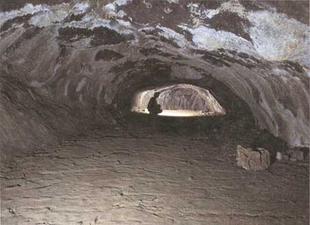
Boulevard Cave and Balcony Cave (map 13, pl. 4) were named by J.D. Howard, who explored them on January 4, 1918. He chose the name "Boulevard" for the cave farthest downstream because of its remarkably smooth floor. This floor is the solidified surface of a former lava pool that filled half the lava tube.
The large entrance chamber of Boulevard Cave—The Flushing Bird Room—is actually a natural bridge, which has been left as a remnant between two surface collapses along a 20- to 30-ft-wide underground tube. Only 30 ft after going underground the trail turns a half circle to the right and climbs a short incline into a distributary tube that branches from beneath the natural bridge. At the top of this incline, 7 ft higher than the tube junction and 20 ft to the north, the trail emerges onto the smooth-surfaced lava pool that gave the cave its name—Boulevard (fig. 48). Farther northeast within the cave, the roof lowers until it is only a 3-ft-high crawlway. Here the floor of the Boulevard drops off in a 2-ft-high lava cascade. The tube continues with a normal downstream gradient for another 250 ft with two tight crawls. This part of the tube was partially drained soon after solidification of the top of the Boulevard pool, but the lava level did not drop enough to reveal the former floor of the tube. Nearly 150 ft beyond the cascade marking the north edge of the Boulevard, the tube divides into two distributaries. The one on the left (west) is filled nearly to the roof, but the distributary on the right makes a shallow S-curve and continues northeast for another 75 ft. Near its end the tube enters a cupola-like dome with a ceiling 9 ft above the floor. However, the tiny outlet of this room is impossible to traverse because there is less than a foot of clearance between the ceiling and floor.
|
| Figure 48. The smooth floor of this tube provided inspiration for J.D. Howard to name it Boulevard Cave (see fig. 4 and map 13, pl. 4). |
Throughout its length Boulevard Cave displays well-formed lavacicles and dripstone walls, but its main attraction is its short stretch of smooth floor (the Boulevard). In the cave's entrance chamber is evidence of how the lava pond that produced the Boulevard was partly drained after solidification of its upper surface, and of the relation of Boulevard Cave to the other caves of this group.
Boulevard Entrance Chamber and East Branch of Balcony Cave
As previously noted, the upstream end of Boulevard Cave is in a broad chamber—The Flushing Bird Room—formed at the junction of two distributary tubes (map 13, pl. 4). The floors of the two tubes are at different levels, and the smooth floor of the Boulevard is 7 ft higher than that of the eastern tube. Yet, at one time molten lava must have been at the same level in both tubes. A high-lava mark present in both tubes shows that the same level as the Boulevard is preserved in several places within the eastern tube's entrance chamber. Some obstruction downstream that had ponded the lava evidently gave way and the lava surface within the entrance chamber was quickly lowered. The Boulevard floor had already congealed, but material just beneath this floor must have been so hot and plastic that it oozed upstream as a backflow that formed a sloping apron 7 ft high and 20 ft long, which now connects the Boulevard with the floor of the East Branch. Stretched bubbles and open tensional cracks remain frozen into this apron surface. Still later, a final surge of hot molten lava entered the entrance chamber from upstream and left a second high-lava mark in the form of a thin yellow lava scum plastered across this sloping apron 2 ft above the present floor. A curious feature of the entrance chamber, rarely seen in lava tubes of this area, is a small patch of waterworn pebbles and sand deposited in the lowest part of the chamber. Evidently, flash floods or rapid snowmelt cascaded into the entrance chamber from the shallow drainage just to the west and deposited loads of sandy gravel in this tiny basin beneath the natural bridge, then filtered out through a maze of coarse collapse blocks. The loose blocks that provided this filter mark the upper end of a collapse trench 80 ft long, which lies on the site of the downstream continuation of the East Branch.
The East Branch tube can be entered through a stoopway at the north end of this collapse trench. Despite the difficulty of low ceilings and a remarkably rough and wavy floor, one can traverse the tube for another 140 ft underground. Evidence indicates that this part of the East Branch tube was completely filled with molten lava at the time of the Boulevard ponding except for one high-ceilinged area 30 ft downstream from the low entrance. Here, a fallen block left a hole in the roof large enough to stand in and peer around a flat-bottomed chamber above the roof of the present cave. Although this chamber is only 1-3 ft high, its dimensions and roof features clearly indicate that it was a high place in the roof of the East Branch tube prior to the Boulevard's ponding. During ponding, molten lava rose to the level of this chamber's present floor, solidification formed a crust 1-2 ft thick, and then the molten lava below drained out, a process which left this balcony remnant 4-5 ft above the tube's present floor.
The East Branch tube can be traversed beyond the balcony in its roof for only another 100 ft downstream. At this point, the cave ends in a floor jam of broken and tilted blocks that prevent further access down the tube. A small well-like hole in the floor may connect to a lower tube, but it is too small to enter. Why is the floor of the East Branch so extremely rough and wavy—a striking contrast to that of Boulevard Cave? One must see and study it throughout its entire length for a valid answer. This surface formed from the last surge of lava that entered the cave after the ponded lava of the Boulevard stage drained out. It left the 2-ft-high lava mark in the entrance chamber. In this part of the East Branch the lava flowed as a narrow lobe containing a tube-in-tube only about 3 ft thick, with an arched roof and steep sides. Narrow troughs between the lobe and the former walls of the cave reveal a pahoehoe floor beneath it. The source that supplied new lava into this thin lobe slowed and eventually stopped, but in the final stages of flow the hot interior of this small arched-roof tube continued to drain, possibly through the well-like feature at the end of the tube. This drainage left a putty-like skin of half-congealed lava on the roof and sides of the lobe that sagged toward the tube's interior and was dragged downstream. The dragging of this lava formed the wave-like folds, basins, and irregularly tilted blocks that make the cave so difficult to traverse. Some of the ridges rose almost to the ceiling and then broke open; the opening reveals the hollow tube-in-tube of the flow lobe. Other ridge parts were pushed down and blocked parts of the outflowing lava. In short, this buckled and twisted final lobe is another form of tube-in-tube. Had it acquired a thicker skin before draining began it would have remained as a typical small tube-in-tube, but the skin was so soft and thin that it collapsed irregularly to form the wavy and broken surface found throughout the 140-ft length of the East Branch.
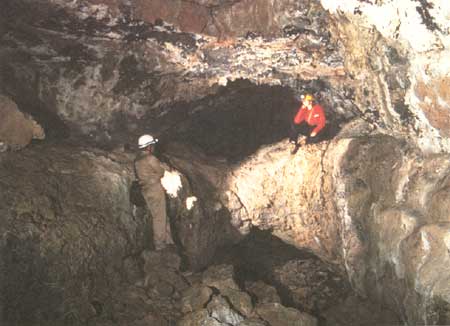
Balcony Cave
Upstream from the entrance chamber of Boulevard Cave is a collapse trench, followed by a second natural bridge, and then another collapse trench (map 13, pl. 4) containing the entrance to Balcony Cave. The reason Howard gave it this name is immediately apparent after walking a few feet into it. As in Boulevard Cave, lava ponded in this much larger lava tube almost to the roof. Enough time elapsed after the lava pool was emplaced so that solidification from the walls formed a crust 2 to 5 ft thick throughout the entire cave. Later the molten lava beneath this crust resumed motion. Because the crust over the deeper central part of the tube was not strong enough to bridge the entire 25- to 40-ft width of this larger tube, its axial section caved into the molten flood to form a channel 4-9 ft wide while parts of the cave system here and upstream drained. This channel is preserved as a narrow trough with nearly vertical walls that rise above the spiny pahoehoe floor at the bottom of the trench. The trail leads up the bottom of this narrow trench, passing under a natural bridge 80 ft upstream from the entrance. Here, for a distance of 10 ft, the balcony remained intact and did not collapse into the narrow channel. Upstream from the natural bridge the central channel continues for another 100 ft to where the channel and balcony above are both buried beneath a large collapse that nearly prevents further access upstream.
The balcony (fig. 49), 11-20 ft above the trail, is fascinating, but many parts are difficult to reach without a ladder or innovative climbing maneuvers. Once on the balcony, travel is slow because the balcony floor is so close to the cave ceiling that one must crawl or walk in a stooped position. At the upstream end of the trail, there is an easy ascent to the balcony where fallen roof blocks form a natural stairway from which one can crawl out upon the balcony west of the central channel. The balcony can also be reached at a place 60 ft downstream, where a small roof collapse has made a hole 5 ft in diameter that is open to the sky. Fallen blocks have been piled high enough in a mound beneath this hole to stand on and reach the west wall of the trench and pull oneself up onto the surface of the balcony. This part of the balcony is particularly interesting because on the west sides of two pillars connecting the balcony with the roof are remnants of a former distributary, which apparently branched from the main tube in the large area upstream now covered by collapse debris. Only a small part of this distributary tube is visible. On the west side of the larger (northern) pillar the balcony surface tilts west into this small tube. Traced to the north, this tube diverges from the balcony at its northwest corner and is almost completely filled with lava to its roof. Upstream the continuation of this small tube follows the west edge of the tilted balcony block, then dives into the walls of a scarp, and continues beneath the untilted balcony floor upstream. The course of this tube upstream beneath the balcony can be followed (crawlspace only) to the place where it is demolished by the surface collapse.
|
| Figure 49. Balcony Cave (see fig. 4 and map 13, pl. 4) derived its name from this balcony, formed when a late flow of lava drained away, leaving its chilled upper surface attached to the walls. |
The balcony on the east side of the collapse trench is a narrow shelf 3-15 ft wide, hanging 12-20 ft above the trench. Access without a ladder is difficult. It can be reached from the balcony on the west side via the natural bridge across the trench, but this approach requires crawling for 25 ft along a narrow ledge formed by the west balcony around a constriction in its west wall. An easier approach is to climb onto the east balcony from the pile of collapse blocks at the entrance to Balcony Cave. Here, the ceiling is sufficiently high for walking upstream on the balcony for a short distance, but it lowers to a level where stooping or crawling is necessary a short distance upstream.
The most interesting feature along this east balcony is the mouth of a tributary tube, which enters the main tube exactly at the balcony level. Only the top of the tributary tube is visible, a fact indicating that lava in the main tube pooled in the mouth of the tributary at the time of ponding. One can enter the tributary from the balcony and traverse it for 450 ft upstream, but this route requires a tight and unpleasant crawl. A much easier access is found farther upstream, through the South Branch of Balcony Cave, as we refer to this tributary tube.
South Branch of Balcony Cave
The South Branch is a very ordinary segment of a small near-surface lava tube. Downstream from the entrance one walks on a normal pahoehoe floor for 60 ft to where the floor is covered with debris from another collapse hole that has opened to the surface. The pahoehoe floor is uncluttered farther downstream, and evidence of a higher stand of lava is recorded as a lava bench 2 ft high clinging to the east wall near this second opening. An alcove on the east wall has a sloping apron that formed when lava standing 2-4 ft higher than the present floor slowly withdrew to the present level. Another 40 ft downstream the roof of the cave lowers, and the floor is increasingly littered with collapse blocks. Nearly 220 ft downstream from where we entered the cave, the pooled lava lies only 1-3 ft below the roof. This lava marks the upstream end of the 35-ft crawlway that leads to the east balcony in Balcony Cave.
If we traverse upstream from the entrance, we find that the tube has a high ceiling, widens abruptly upstream, and divides around a large (120 by 30 ft) pillar. The wider branch is on the west side of this big pillar, and a small pillar also lies in the middle of this wide channel. The ceiling lowers, until at the south end of the large pillar the roof over much of the area is only 2-4 ft above the channel. Here the channel appears to split into three channels upstream—or there may be just two roof dividers within a wide channel filled almost to its roof with lava (see map 13, pl. 4). Whatever the geometry, access ends because each of the three strands is blocked upstream by the large collapse area that surrounds the entrance to Balcony Extension. From the southeast corner of the large pillar a wider and better exposed tube starts upstream, but be comes inaccessible in 60 ft because it, too, is filled with lava and fallen blocks from roof collapse.
Balcony Extension
The more interesting parts of Balcony Extension are accessible near the main road. A large collapse pit lies 20 ft northeast of the road. At the bottom of the north side is an arched entrance through which you can walk into Balcony Extension.
The last flow to enter the cave emerges 15 ft inside this entrance from beneath the pile of collapse rubble that covers the floor on the north and west sides of the entrance. This basalt flow advanced downstream along the floor of the cave as a sticky lobe of spiny pahoehoe only 3-6 ft thick. Its surface was pushed in the direction of flow into complicated arcuate ridges. The surface crust of this lobe is also riven by large longitudinal fissures along its crest and by curving cross fractures. Some of these breaks opened far enough so that you can see the hollow interior of the flow. This flow lobe, in other words, was a collapsing tube-in-tube, similar to the one in the East Branch of Boulevard Cave. The main difference is that the crust of this lobe was thicker; therefore, brittle cracking accompanied the bending as support of the semiplastic crust was withdrawn by draining of the tube-in-tube.
As in the East Branch, this sticky lobe did not spread to the walls throughout the cave. The old smooth pahoehoe floor that it covered is generally visible as a narrow strip between the lobe and the cave's walls. Sixty feet downstream from the entrance two branches of the main tube reunite after having flowed around a large pillar just west of the entrance. The floor of the tube in this area is a pool. The lobe of spiny pahoehoe evidently spread across this pool when it had a congealed crust but a still plastic interior. The crust on the pool bowed down toward the edge of the new lobe and cracked in places or heaved up to accommodate the weight of encroaching spiny pahoehoe.
This partly deflated tube-in-tube of spiny pahoehoe can be followed downstream 180 ft toward Balcony Cave from the entrance. It is lost under extensive collapse debris 80 ft upstream from the crawlway exit that leads to the surface collapse basin. Parts of this large pile of debris consist of broken sheets of lava plastered onto the roof of the cave during early ponding. One such sheet 20 ft long, 8 ft wide, and 2 ft thick still hangs attached to the roof but is pulled away from it as much as 3 ft at one end. Along the east wall a small tributary tube floored with pahoehoe enters the main tube but is filled with lava 25 ft upstream. Access through the collapse block to the exit hole at its end is found adjacent to either wall of the tube.
It would be interesting to know whether the collapsing tube in Balcony Extension is the same flow as the spiny pahoehoe lobe that occupies the bottom of the trench in Balcony Cave, but the evidence is hidden beneath collapse breccia that denies access for 160 ft between the two caves.
Another distributary branch leaves the Balcony Extension tube to the left (west) 130 ft downstream from the entrance. It flows northwest for 45 ft and turns in a broad arc to the north and northeast for another 100 ft, where it expands into a large room over 50 ft across. This room is shaped like an inverted saucer because it is filled nearly to its roof with collapse debris. Anyone wishing to traverse it will find that the easiest course is along the wall on its west and northwest side. The north end of this tube has been demolished by a roof collapse. Two crawlholes through blocks at the north end of this room serve as alternative exits into a surface collapse pit, as noted earlier. The route along the west wall leads directly to one of them. Except for the large debris-choked room, this distributary is a normal small lava tube, which drained and left a floor of ropy pahoehoe. However, this distributary affords the only entrance into Sharks Mouth Cave—one of the most fascinating caves of this group.
Sharks Mouth Cave
In the big room partly filled with collapse debris described previously, a small tube extends from the floor into the east wall. Although 8 ft wide, this tube is scarcely noticeable because its roof is so low that one must lie on the floor to peer into it (map 13, pl. 4). Shine a light down it and note that as the tube drops lower its floor appears from the rubble as a gently sloping lava cascade, and that roof and floor are close together until only 2 ft or less of space separates them. Focus light to illuminate the area beyond this tight opening and see that within 10-15 ft the floor ends against a vertical wall. The logical conclusion is that this is a short dead-end cave filled to the roof with congealed lava. However, if you crawl down into the tight section, you find the tube makes an abrupt right-angle turn to the north. Beyond the area where it turns right, the tube is wider, its gradient steeper, and the ceiling height doubles to 4 ft. Follow the tube downstream for 70 ft, past a pile of collapse rubble on the left, and it widens out into a room over 80 ft wide but only 5 ft high. Evidently this room is the upper part of a large tube, supported in its middle by two pillars, which extends downstream (to the north) for another 275 ft to where access is blocked completely by lava filling. The cave is 50-80 ft wide where it divides and reunites at the ends of the two pillars. Downstream it narrows to 30 ft and then 20 ft, yet the ceiling heights are only 3-4 ft throughout nearly all of the cave.
How was a cave of such great width and low ceiling height formed? It seems that the original lava tube was large, with ceiling heights of at least 6 to 10 ft. It occupied a deeper level than the Balcony Extension distributary upstream. There was probably another connection between these two lava tubes, perhaps a lava fall now buried under the surface collapse that demolished parts of both caves. In the last stages of lava occupancy this lower tube filled almost to its roof, and then the lava congealed completely without further draining of the molten interior. A tight seal of lavacicles on the cave's roof has slowed or prevented ingress of pumice, clay, and caliche from the surface.
Although this cave is difficult and even painful to traverse, the lava-cave enthusiast will be delighted with the perfection and cleanliness of its lavacicle-encrusted roof and with the untarnished quality of the intricate patterns of pahoehoe ropes on its floor. Very likely the last stream of molten lava filled the cave to its roof, then slowly lowered 2-4 ft. Lava may have continued to splash the roof with molten material as long as flow continued because in places the roof is a forest of spiny, black lavacicles, some of which are several inches long. Evidently some of them continued to elongate as successive splashes hit the ceiling. The floor, too, is composed of similarly clean jet-black glassy lava twisted into pahoehoe ropes dotted with short lavacicles that fell from the roof while still plastic. Scarcely any sediment or dust litters the floor except near the collapse breccia at the upper end of the cave.
While crawling and shining a light ahead to gauge the distance between lavacicle-studded roof and rough pahoehoe floor, notice the resemblance of the cave's cross section to the slightly opened mouth of a shark. We have therefore given it the name "Sharks Mouth Cave."
Other Caves
A maze of dead-end crawlways surround the deep collapse pit that serves as the entrance to Balcony Extension, and some are shown on map 13, plate 4. A continuous traverse can be made around the large pillar just west of the entrance via a group of crawls. There are many more tight crawls on the south and southeast side of the breakdown, one leading to a very small skylight opening just southwest from the main road. Undoubtedly the tube from the Balcony Extension entrance once extended upstream to the Upper Cavern and it was connected downstream with Balcony's South Branch upstream end, but a wide and extensive area of collapse rubble now obscures the exact relations.
The numerous passages southward from Balcony Extension are in an area where many blocks in the ceiling remain loosely suspended, and some loose blocks on the floor shift under one's weight.
Southwest of the main road, along what is the upstream continuation of the Balcony-Boulevard distributary, is the large Upper Cavern, 90 ft long and as much as 40 ft wide. It, too, has undergone extensive collapse, and most of the original features of its roof and walls have fallen to the cave's floor. At its south (upstream) end there is a natural bridge and a long collapse trench.
| <<< Previous | <<< Contents >>> | Next >>> |
bul/1673/sec3e.htm
Last Updated: 28-Mar-2006