
|
Geological Survey Bulletin 1673
Selected Caves and Lava Tube Systems in and near Lava Beds National Monument, California |
OTHER CAVES IN OR NEAR THE MONUMENT
(continued)
Heppe Caves and the Mammoth Crater-Hidden Valley Area
A semipermanent supply of ice-cold water forms a pool, 40 ft wide and (depending on the season) as much as 12 ft deep, on the floor of a cave 0.5 mi north of Mammoth Crater (map 19, pl. 6). Attracted by this supply of good water, Bertha and Earnest Heppe filed a homestead claim on the land containing the cave, despite the inhospitable nature of the surrounding area for agriculture. This cave and a second cave a short distance from it became known as the Heppe Caves. Also, a small agglutinate cone west of the upper cave was named "Heppe Chimney." Several years later, J.D. Howard named a lava-tube cave lying about 1.5 mi east-southeast of the Heppe homestead Berthas Cupboard Cave in honor of Bertha Heppe.
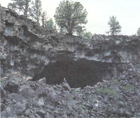
The Heppe homestead was abandoned long ago, but the old wagon road that led to the site of their house is still visible and is used as a trail. It merges into the main Medicine Lake-Lava Beds road at a sharp bend 0.3 mi from the Heppe Caves. At the west end of the wagon road a trail descends the south rim of a steep-sided collapse. From the bottom of this collapse pit a rock-walled trail constructed by the Heppes leads deeper underground by zigzagging down a talus slope to the surface of the water pool. Access to Lower Heppe Cave is easily gained by walking north out of Upper Heppe Cave into a second very deep collapse pit (labeled "Central Collapse" on map 19, pl. 6) surrounded by spectacular cliffed walls. From Upper Heppe Cave, cross over the bottom of this deep pit past Heppe Grotto, and proceed into the cavernous opening of Lower Heppe Cave (fig. 66).
|
| Figure 66. Entrance to Lower Heppe Cave (see map 19, pl. 6). |
At the request of Paul Haertel, former superintendent of Lava Beds National Monument, we mapped the Heppe Caves at a scale of 40 ft to the inch. A reduced-scale version of this plan is used an inset on map 19 (pl. 6), but the main purpose of the map is to depict the source areas of four major lava dispersal systems whose lava came from Mammoth Crater or from the dike-filled fissures that intersected Mammoth Crater during the periods of volcanism. The Bearpaw Skull lava-tube system also had its source in a lava lake fed from Mammoth Crater and its dikes. Donnelly-Nolan and Champion (1987) preferred the interpretation that this tube system was fed from Modoc Crater, another vent for the basalt of Mammoth Crater.
Some other features shown on map 19, plate 6, are Eagle Nest Butte, which is a deeply eroded cinder cone older than the Mammoth Crater lava, and a small part of the Callahan flow of blocky lava. This young flow is almost free of vegetation and it was erupted from the base of Cinder Butte, a cinder cone in an isolated area near the southwest corner of the monument (see fig. 4).
Geology of the Heppe Caves
The Heppe Caves are remnants of a large lava tube, originally 25-30 ft wide and 15-25 ft high. Nearly all primary features have been lost by slow collapse of the roof and walls. Behind the places where blocks of dripstone lining have fallen, one can see edges of the flow units. These units are separated by sporadic accumulations of bombs and ash; most units are less than 3 ft thick, and many have ropy pahoehoe tops. These flow units dip to the north, away from Mammoth Crater. Less well defined flow units with only sparse accumulation of pyroclastic material between them are present higher on the walls, especially in the scenic cliffs that ring the top of the collapse pit separating the two Heppe Caves.
In the Upper Heppe Cave floor, a permanent mass of ice probably fills the interstices between the collapse blocks. When we mapped the cave in late May of 1976, the topmost edges of this ice mass could be seen in spaces between the fallen blocks around the edges of the water pool and also all along the floor of the alcove that extends into the east side of the cave (map 19, pl. 6). The lobes of ice between the blocks had sharp crests, similar to seracs on the surface of a glacier. In September 1977, no ice was visible and the pool was dry, whereas during 1985 to 1988 the ice block and pool were present.
Lower Heppe Cave is so defaced by collapse blocks that no original features remain in place. Nevertheless, it is evident that a collapse of an upper tube into a lower tube dropped both ceiling and floor 20 ft. Thus, the upper tube did not continue downstream but must have ended in a semicircular wall, as did the upper tube in Skull Cave (map 12, pl. 4). An oval collapse pit (labeled "East Collapse" on map 19, pl. 6), with a hydraulic rampart of loose blocks piled on its northern lip, ends Lower Heppe Cave. On the east side of this collapse pit, a remnant of the lava tube plunges beneath a narrow natural bridge, Heppe Bridge. Beyond this bridge the line of collapsed trenches continues around the south and east sides of Red Butte, but they are small with only a few caves open to the surface until the Natural Bridge area at the southwest end of Cave Loop Road (map 5, pl. 2). It is apparent, however, that large tubes were required to transmit the lava to the caves along Cave Loop Road and then eastward through Post Office Cave (map 15, pl. 5). Sections of these large tubes are filled with lava or ice where they have not been destroyed by collapse.
Heppe Chimney
Heppe Chimney is an agglutinate or spatter cone. Such cones are built of pasty bombs that spattered out of a vent and welded into a coherent conical mass enclosing the orifice. In addition a sticky spillover of lava emerged at the northeast base of this cone and spread to the northeast for 20 ft before it solidified.
The connection (if any) of the Heppe Chimney with the adjacent Heppe tube is obscured by talus. It seems likely, however, that the Heppe Chimney is a rootless volcano—that is, it was built through a skylight on the roof of an active lava tube, not as part of a dike arising from a deep magmatic source. However, dikes trending north-south appear in both the north and the south walls of Mammoth Crater, and it is possible that the Heppe Chimney may lie above a northern extension of one of these dikes.
Mammoth Crater
Mammoth Crater (fig. 4 and map 19, pl. 6) is a funnel-shaped pit slightly more than 0.25 mi in diameter and 340 ft deep. Eighty percent of its steeply sloping walls are mantled with talus. A cliff of thin flow units forms the southwest wall just below the crest, and these flows also continue eastward to form a broad sloping shelf, which lies well beneath the crest along the southeast wall of the crater. In a notch on the south wall several small vertical basalt dikes cut through the cliff of lava flows. On the south slope of the Mammoth shield is a large spatter rampart 660 ft long and 50-100 ft high, which obviously marks the southward continuation of the dikes. The rampart contains two elongate spatter cones with deep clefts on their ends, above the position of the underlying dikes.
On the opposite (north) slope of the Mammoth shield are two large, shallow talus-covered depressions that resemble the pit craters of Hawaii. Such craters are generally attributed to subsidence of crater walls into underlying dikes of molten magma. These depressions, however, may be only wide collapse trenches over shallow lava tubes that surmount the line of dikes. In any case it is apparent that large lava tubes transmitted great quantities of lava northward beneath the two craters, and then into three systems of lava tubes. As they leave Mammoth Crater the feeder tubes surmount, or possibly lie partly within, the northward extension of the plexus of dikes on the north wall of Mammoth Crater.
Two examples of filled lava tubes surmounting basalt dikes can actually be seen, despite partial masking by loose talus blocks, on the north wall of Mammoth Crater (map 19, pl. 6). That the higher and westernmost tube of this overlapping pair shows many thick concentric shells of lava indicates it was filled and drained numerous times. The massive, coarser grained texture of lower and older tube filling indicates that lava ponded within it for a long time prior to solidification. Both are oriented north-south and extended beneath the nearby pit craters on the north slope of the Mammoth shield. Note on the map that a lava gutter nicks the margin of Mammoth Crater above the deeper and older lava tube. A later blanket of tuff and lava prevents tracing the gutter beyond the crater rim.
Another filled lava tube is poorly exposed in the talus slope that forms the east wall of Mammoth Crater just north of the bench of basalt lava flows. This filled tube plunges east and transmitted lava eastward from Mammoth Crater into the Hidden Valley area.
Hidden Valley
The head of Hidden Valley (map 19, pl. 6) is a cliffed amphitheater with walls 60-100 ft high that lies "hidden" by a forest of conifers on the southwest and a dense thicket of mountain mahogany on the north and northeast. It is always a surprise to emerge suddenly at the top of a high cliff after beating your way through the dense vegetation that borders this amphitheater on the north side. A short trail, however, leads to the top of the westernmost cliff and a longer unpaved trail skirts the south edge and descends to the floor of the valley.
The origin of Hidden Valley is enigmatic; it may have been a lava channel that enlarged laterally and headward as the eruption proceeded. Downstream from Hidden Valley, the basalt that must have flowed through this channel was buried by the younger basalt of Valentine Cave. The size of Hidden Valley suggests that a major tube system from Mammoth Crater once occupied or emerged from this valley and fed lava flows that extend east of the monument nearly to California Highway 139.
Former Lava Lake North of Mammoth Crater
When volcanism began at Mammoth Crater, the topography was probably more diverse than it is today. Clusters of steep-sided conical buttes, northward-sloping lava flows, and north-trending fault blocks dominated the landscape. Mammoth Crater is located 8 mi northeast of Medicine Lake, which lies in the caldera of the Medicine Lake shield volcano (Anderson, 1941). The flanks of this huge shield are embellished by more than 200 satellite volcanoes, including many steep-sided cinder and agglutinate cones such as Schonchin Butte (fig. 67), rounded lava domes, and stubby flows of obsidian. Some andesitic volcanoes were built over the fault zones that define the caldera rim. Numerous studies of various aspects of Medicine Lake volcano include Mertzman (1977), Grove and others (1982), and Donnelly-Nolan (1988). A geologic field trip guide to Medicine Lake volcano and Lava Beds National Monument is also available (Donnelly-Nolan, 1987).
|
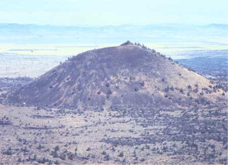
| Figure 67. View of Schonchin Butte from top of Hippo Butte. Schonchin Butte is the principal landmark within the Lava Beds National Monument. A trail to a fire lookout at the top provides excellent views. |
The Mammoth basaltic shield differs greatly in form from the many nearby steep-sided cinder and spatter cones because its lava flowed downslope in smooth lava flows and in tubes. Only rarely did the Mammoth vent expel large quantities of ash and bombs. Had the Mammoth shield been built on flat ground, its flows would slope away on all sides from the central crater. Because Mammoth Crater formed on the already sloping flank of a much larger shield, however, most of its lava traveled downslope to the north and east. The lava was diverted at many points by older cinder and spatter cones and lava flows such as Schonchin Butte and the Schonchin Butte flow. Locally the lava ponded in swales between obstructions such as the cones and north-trending fault blocks.
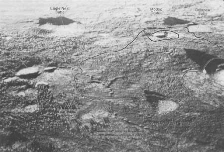
Downslope from Mammoth Crater a cluster of six cinder and spatter cones in various stages of erosional truncation combined to dam a large lava lake (fig. 68). The lake, fed from Mammoth Crater, lay ponded during the active stages of volcanism but evidently fluctuated erratically in level as different surface outlets along its periphery formed and closed as the lava congealed. Short-lived overspills occurred along the periphery of the lake while occasionally a more permanent outlet would open underground as the increasing hydraulic pressure of the ponded lava overcame a blockage in a lava tube. In the last stages of this lake's existence, and after a crust at least 5 to 10 ft thick had congealed over its surface, the molten interior of the lake drained toward an opening approximately 50 ft below the lake's former level. This opening occurred at a point 0.3 mi downstream (east) of the Heppe Caves, where the feature labeled "back-flow outlet" joins the line of breakdowns (fig. 68). As the level of the lake dropped, its solid surface crust broke into blocks, which moved toward the newly opened drain and produced a tangle of fissures and schollendomes. Heavily fissured ground now occupies nearly two-thirds of the former lake's surface. It is very difficult to traverse this ground because of its uneven surface and the thicket of mountain mahogany, which grows in profusion wherever deep fissures provide opportunity for roots to reach water. The strong limbs of this vigorous tree-like shrub make an almost impenetrable tangle.
|
| Figure 68. Oblique aerial view (westward) of former lava lake (outlined), now a maze of rugged collapsed lava. Distance from Bearpaw Butte to Red Butte is about 2 mi. Drain for lake is at Y-shaped intersection of breakdowns west of Red Butte. See fig. 4 for location of these features in Lava Beds National Monument. |
Prior to the opening of the drain around Red Butte, another larger drain at a higher elevation may have stabilized the molten lake level for a long period of time. This outlet was connected to the now-collapsed upstream continuation of Bearpaw Cave (see map 10, pl. 4), and may even have changed its position and depth within the tangled expanse of north-sloping lava lobes between Hippo and Bearpaw Buttes before the outlet became entrenched in the loose ash and cinders along the east side of Bearpaw Butte (fig. 4).
Before the lava lake filled to its highest level, much lava from Mammoth Crater had escaped to the northwest through the gap between Bearpaw and Eagle Nest Buttes. These flows rounded the west base of Bearpaw Butte and followed the swale east of Gillem fault (fig. 4) to the shoreline of former Tule Lake. A major lava-tube system developed within these flows, most of it older than the Bearpaw-Skull system whose flows overlap it. As shown on map 19, plate 6, the shallow basins with slumped edges and the surface gutters labeled "Heppe-Modoc system" lie on the top of a ridge that topped the near-source part of this major lava-tube system late in its development. Direct connection downstream, however, is lost in a steeply sloping field of schollendomes and tangled lava lobes and gutters, which lies west of Modoc Crater and northwest of Bearpaw Butte. That the west shoreline of the lava lake once abutted Heppe Modoc ridge indicates that the ridge predated the highest level of the lava lake.
The Bearpaw-Skull line of breakdowns is in vertically stacked tubes that began in a lava lake fed by eruptions rising in or near Mammoth Crater. The lava that flowed into Tule Lake at Canby Bay was also delivered via lava tubes originating in Mammoth Crater. Earlier observers (and more recently, Donnelly-Nolan and Champion, 1987) thought the Bearpaw-Skull line of lava tubes was fed from Modoc Crater. However, Modoc Crater is apparently surrounded by a sea of Mammoth lava that flowed around it, united on its north side, and impinged against the southeast part of Bearpaw Butte. The collapse trench upstream from Bearpaw Cave began within this Mammoth lava. No feeder tube from Bearpaw Butte intersects this tube or its breakdowns; instead, the tube cut into and displaced the loose ash forming the east slope of Bearpaw Butte.
A small cone on the north flank of Bearpaw Butte did erupt after Bearpaw and Merrill Ice Caves were formed. From this vent a small lava tube, built entirely upon the surface, coursed down the north slope of the satellite cone and stopped at the edge of a large collapse pit in Mammoth lava that flowed around the base of Bearpaw Butte.
Shoreline of the Lava Lake
To support the interpretation that both the Bearpaw-Skull and Cave Loop Road lava-tube systems originated from a former lava lake fed from Mammoth Crater additional details are needed to document the position of the shoreline of this lake during its most recent stand. Evidence of the shoreline can be observed on the sides of all of the buttes that helped to contain the lake on its north and east sides (fig. 68). Red Butte is closest to the outlet that drained the lake. Remnants of the black Mammoth lava, joined to the reddish pyroclastics of Red Butte, are well exposed where the paved road rounds the northwest side of the butte. Here the elevation of the lava shoreline is 5,160±10 ft.
The next butte to the north is Hippo. On its southwest flank, parts of a bench of basalt marking the highest shoreline adhere to the side of the butte at 5,180 ft elevation.
Sighting with a hand level from this point to Modoc Crater and to Bearpaw Butte, roughly a mile to the west, one can pick out reference points at the same elevation. These points, and others identified on the ground as the highstand of Mammoth lava against both Modoc Crater and the southeast side of Bearpaw Butte, all fall between the 5,160 and 5,200 ft contours on the U.S. Geological Survey Medicine Lake 15-minute quadrangle map. Considering the rough margins typical of lava lakes, this is good agreement.
On the southwest side of the lava lake, no older buttes display a definite shoreline. However, the fissured and schollendomed area thins and eventually disappears against the higher topography of the preexisting Heppe-Modoc ridge formed by the Heppe-Modoc lava tube (fig. 68) below the 5,200-ft contour (see U.S. Geological Survey Medicine Lake 15-minute quadrangle topographic map).
A lava lake should not be thought of as similar to a lake of water in a temperate climate. An arctic lake (or sea) with its crust of ice is comparable, but notable differences remain. Even during the course of a major eruption, a lava lake would be partly covered with congealed blocks as seen during the slow transit of an almost complete cover of floating blocks across the Mauna Ulu lava lake in Hawaii during major eruptive activity. Such blocks of congealed crust will tend to jam together and block any surface outlet, a process which causes constant shift in the position of the outlets and corresponding fluctuations in the elevation of the lake level. Evidence that tangled surface lobes of block-rich lava escaped from many points on the perimeter of the lava lake north of Mammoth Crater can be seen where irregular skeins and lobes of lava poured out and solidified with steep slopes facing to the east between Red Butte and Hippo Butte, to the north between Hippo Butte and Bearpaw Butte, and to the northwest in the area west of Modoc Crater and southwest of Bearpaw Butte. Underground outlets (lava tubes) have a better chance of being preserved when they tap the molten lake beneath its solidified crust. With waning volcanism, however, they become blocked with lava jams and drain out as the lake level drops and its crust collapses into an expanse of schollendomes.
Upper Ice Cave
Upper Ice Cave is a small lava tube filled with ice that extends beneath the edge of the younger Callahan lava flow just south of Eagle Nest Butte (see map 19, pl. 6). Upstream from the cave, a mile-long chain of shallow breakdowns, small lava gutters, and short lava tubes can be traced toward the two pit craters north of Mammoth Crater. The place where they join the lava tubes from Mammoth Crater is lost beneath a blanket of younger pyroclastic debris and lava lobes from the crater. It seems likely that the Upper Ice Cave line of gutters and shallow breakdowns is a minor distributary developed in the last stages of building the Heppe-Modoc lava-tube system, which extended from Mammoth Crater through the gap between Eagle Nest and Bearpaw Buttes and then on to Canby Bay (fig. 4). Two similar but smaller lava gutter systems drained off this ridge to the west, and each of them originated in small sag basins that cap this ridge north of the Upper Ice Cave lava gutters.
Callahan Flow
The Callahan flow composed mostly of aa and block lava (fig. 69) is the youngest geologic feature in this area. Donnelly-Nolan and Champion (1987) report a radiocarbon age of 1110±60 yr B.P. Much of this large lava flow poured from a boca (the Spanish word for mouth) on the side of Cinder Butte, a steep-sided cinder cone with a small undissected crater at its top. Cinder Butte is located 0.5 mi south of the southwest corner of Lava Beds National Monument (fig. 4).
|
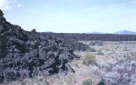
| Figure 69. Edge of Callahan flow near Whitney Butte, west side of Lava Beds National Monument. Flow front of block lava is about 30 ft high. Callahan flow is about 1,100 years old, youngest in the monument. |
| <<< Previous | <<< Contents >>> | Next >>> |
bul/1673/sec3k.htm
Last Updated: 28-Mar-2006