
|
Geological Survey Bulletin 1673
Selected Caves and Lava Tube Systems in and near Lava Beds National Monument, California |
OTHER CAVES IN OR NEAR THE MONUMENT
(continued)
Collapse Trenches Between Skull Cave and Three Bridges Area
More than 40 small caves, and a few that can be traversed for more than 300 ft, lie downstream along the same lava-tube system that contains Skull Cave (map 20, pl. 6). Collapse has obliterated most of the primary features of many of these caves, as well as segmenting the tubes into short sections with floors so cluttered with rubble that they are difficult to traverse.
The larger and more interesting caves along this tube system are shown on maps 10, 11, and 12 of plate 4 and described in previous sections on Bearpaw, Merrill Ice, Kirk Whites, Beaconlight, and particularly Skull Caves. Therefore, associated surface features—the breakdowns, sag basins, skylights, surface spillovers, and various kinds of hydraulic ramparts that surround or partly border some of the collapse trenches—are shown on map 20, plate 6. It shows the surface features along a 5-mi stretch extending downstream from the collapse trench at the head of Skull Cave. This part of the lava-tube system zigzags along in a broad curve around the older Schonchin Butte flow (fig. 70). Near the north end of the Schonchin Butte flow, many distributaries branch off to the north and are lost in a field of schollendomes that occupy a broad band within the monument between Captain Jacks Stronghold and Fern Cave.
|
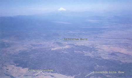
| Figure 70. Aerial view southwest showing snowcapped Mount Shasta in hazy distance. Schonchin Butte and its block lava flow showing in foreground as dark area near center of Lava Beds National Monument. Elongate dark patches south and east of Schonchin Butte flow are collapse trenches formed along Merrill Ice-Skull Cave lava tube, which formed in basalt of Mammoth Crater that flowed around the preexisting Schonchin Butte flow. |
Skull Breakdown to Captain Jacks Bridge
A large collapse trench gives entrance to Skull Cave. Vehicles can be left at the Skull Cave parking lot. From this point the unpaved part of Lyons Road (now abandoned and closed to all vehicular traffic because it is within a wilderness area) furnishes a good access trail, which lies close to the lava-tube system for the first 2.5 mi.
Skull Cave breakdown is one of the largest and deepest collapse trenches in the monument. Cliffed walls around its edge provide excellent exposures of flow units within a thick lava flow. From the base of these cliffs long talus piles of very coarse blocks merge into an irregular and hummocky sea of tumbled blocks of all sizes. Looking downstream into the entrance of Skull Cave (fig. 47), one is startled by its thin roof and the realization that it is only a matter of time until the collapse trench will extend throughout the entire length of Skull Cave.
The next collapse feature downstream is offset 600 ft southeast from a point on the surface that lies above the downstream end of Skull Cave. It is a roughly circular shallow depression about 300 ft in diameter, located on the south side of Lyons Road. Parts of it are so overgrown with brush that it is difficult to tell whether this feature is merely a sag basin with gently tilted edges or whether its margins were let down by small displacements along numerous arcuate faults. Near its center is a small pit that is surely the surface expression of collapse into an underlying lava tube. Just east of the rim of this basin lies a deep collapse hole that reveals a tiny remnant of the lava tube at its base. Another deep collapse, 350 ft to the east, opens up another two short sections of lava tube that J.D. Howard named Robin Cave and Ship Cavern. Farther northeast is a somewhat larger elongate collapse that is the entrance to White Lace Cave, named by Howard from the open filigree of white caliche decorating nearly all of this cave's roof and walls. Within this cave, a steep connector slants down to the north into a lower tube.
Southwest of White Lace Cave the line of collapse features turns to the northeast. Downstream another 600 ft is an oval sag basin with walls that slope gently toward its center. In places, cracks and small faults rift the basin's margins. Occupying the central part of this shallow basin is a "cork" bounded by a ring fracture. It appears to be part of the roof of a lava tube, which was uplifted slightly when molten lava was present and then stuck in its present position when the lava in the tube lowered and the sag basin formed.
Just beyond the northeast edge of this sag basin is a deep collapse trench—the trace of a large lava tube whose roof has collapsed. At the northeast end of the trench one can enter a cave, which continues the tube to the northeast. Thin flow units are well exposed on the upper walls of the collapse trench. A spillover surface flow escaped from the northeast end of this collapse and flowed east in a channel 8 ft deep at the point where it joins the northeast end of the breakdown. This lava spillover is the first evidence that an obstruction, probably a roof collapse, occurred somewhere downstream while molten lava was flowing through the tube. The obstruction forced lava to back up behind it, as recorded by several features. Downstream 440 ft and across Lyons Road is a tiny skylight out of which three small overspills of lava emerged, flowed several tens of feet, and then solidified. Farther downstream 200 ft is another shallow depression with overspills of lava on its east side. Nearly 50 ft farther is the upstream end of an unusual-shaped large collapse trench with hydraulic block ramparts (fig. 46) rising to heights of 10-15 ft along its southeast margin. This large roughly "C" shaped breakdown probably marks a site where a major lava tube was temporarily blocked by roof collapse and then reopened by magma forcing a detour around one side of the collapse. As the molten lava backed up behind the collapse, it raised and tilted a segment of the tube's roof high enough to shed a wall of talus blocks, which form the hydraulic rampart (map 20, pl. 6) along its southeast margin. The backed-up lava also produced the spillover tubes and lobes from the skylight and trenches upstream. When flow of lava in the tube was resumed, either by forming a bypass around the obstruction or by entraining and bulldozing the collapsed blocks, the raised parts of the tube's roof lowered; thus, the direction of tilt of the roof blocks that previously had shed the rampart talus was reversed. Moreover, after volcanism had ended, further collapse toppled the roofs of both the original tube and its bypass. This produced the odd shape of the breakdown and also closed entry to this part of the lava tube. A downstream section of the tube, however, can be visited beneath Peninsula Bridge, which lies at the northeast end of this oddly shaped breakdown.
Northeast from Peninsula Bridge are three short collapse trenches separated by two natural bridges. At the north edge of the third trench a filled skylight is present on the surface. Out of this skylight narrow spillover lobes of lava emerged and built miniature lava tubes above ground. These surface tubes spread to the north and east, and they cross over an uncollapsed part of the main lava tube. One of these surface tubes then splits into four smaller distributary tubes (map 20, pl. 6).
The next feature downstream is a collapse trench 400 ft long. The ground adjacent to this trench is riven by a few curved fissures labeled "cracks" on map 20, plate 6. Access to a section of the lava tube can be made from the northwest edge of the breakdown. The tube continues beneath a natural bridge for 300 ft to a point where it is demolished within a collapse trench that trends northwest—almost at a right angle to the upstream trend. At its downstream end, however, this collapse trench curves right (north) and this curved trench gradually resumes the former northeast trend of the lava-tube system. Along the northeast side of this curving collapse trench, many short spillover lobes of molten lava emerged, solidified, and then were decapitated by collapse into the trench. On the opposite (southwest) side of this curving collapse trench, a group of shallow sag basins lowered the ground surface irregularly and a short lava spillover emerged from one of the sag basins. The lava tube continues northeastward beneath another lava bridge at the northeast end of this curving breakdown and is closed by a small collapse pit 350 ft farther downstream.
The next breakdown to the north is one of the most interesting collapse features along this part of the lava-tube system. It is shaped like half a coke bottle lengthwise and laid on its side with the sawed surface upward. It is located just southwest of Frozen River Cave and of the point where the tube system passes beneath Lyons Road (map 20, pl. 6). The neck of the bottle is a normal-width small collapse trench. The body of the bottle, however, is a large, shallow collapse area more than twice as wide as nearby accessible parts of the lava tube. The collapse's central part is strewn with blocks from the former tube's roof, some of which are as much as 20 ft in length. Similar large roof blocks, partly included within a talus pile of smaller roof blocks, are tilted outward away from the breakdown and form a continuous hydraulic rampart perched on the rim of the breakdown. This encircling rampart rises 3-35 ft above the surface of the surrounding plain. The tilted blocks and accompanying talus forming the rampart must have been shed outward upon the rim when molten lava, under hydraulic pressure within the underlying partially blocked lava tube, pried loose and heaved upward a large area of the tube's roof, a process which caused it to shed collapse material on all sides. Evidently the pressure was relieved downstream before molten lava could surface through this heaved-up roof. As the lava drained from the tube, the shattered roof blocks were lowered and jostled together to form the floor of the present depression whose surface now lies well below the rampart on its rims. Originally the rampart was continuous across the neck of the bottle, but this part of the rampart has tumbled into the short collapse trench forming the neck of the bottle.
The entrance into Frozen River Cave is at the mouth of the bottle. One hundred feet inside the cave a steep loose connector can be negotiated to a lower level that contains ice during most of the year. J.D. Howard named Frozen River Cave from the ice floor in this lower tube and in an alcove on its east side.
From Frozen River Cave the lava-tube system can be traced downstream on the east side of Lyons Road on a northeasterly course for 1,300 ft before it turns north. Two small collapse trenches reveal the position of the lava-tube system along this northeast trend, but entry into the tube is impossible from these breakdowns.
The northerly trend continues without entrances to caves for 1,700 ft to Captain Jacks Bridge. The approximate position of the lava-tube system, however, is apparent from two large breakdown complexes, which resemble—but are more complicated than—the coke bottle-shaped breakdown upstream. Both lie a short distance east of Lyons Road. The southernmost is a teardrop shaped area 760 ft long and 240 ft wide across its blunt northern part, but it tapers to only 40 ft wide at its south end. On its east side this area is bordered by a 5- to 25-ft-high block rampart containing some short tilted-block sections. This rampart curls around the north end for a short distance, but the west margin of the teardrop is a jagged low cliff with little or no rampart material on its top.
The interior of this area is a maze of broken roof blocks. Five large pieces can be recognized (shown on map 20, pl. 6). Each consists of a fairly intact, although somewhat broken, part of the roof. Each piece appears to have been rafted toward and slightly raised against its neighbor to the north. Minor block ramparts tend to form on the north and northeast edges of the interior blocks, but in other places a carpet of loose blocks separates the different pieces. One large fissure, with blocks piled above its east edge, mirrors parts of the eastern wall of the breakdown. Out of this fissure, and much more copiously out of the break that forms the east edge of this complicated area, small spillovers of molten lava emerged and flowed to the north and east beneath or through gaps in the rampart. Three of these spillovers are large enough to be shown on the map, whereas other miniature spillovers barely reached the surface between the interior rafted blocks. That two tiny holes on the floor of the western part of the broad area of the teardrop were probed with a 13-ft-long stadia rod without touching bottom indicates the presence of a drained lava tube beneath.
At the north end of this complex, a 40-ft-wide strip of ground with low indefinite sags extends along the northerly trend for another 210 ft. The hummocky surface suggests the presence of a large tube, but we could find no entrance into it. To the north this strip of uneven ground is demolished by a large oval breakdown 440 ft long and 215 ft wide. This breakdown is rimmed by block ramparts (and by a short stretch of tilted rampart) 5 to 20 ft high, except across its north end. Here the oval breakdown is nicked by a smaller younger oval collapse oriented at a 450 angle to its larger companion. This smaller collapse feature is also surrounded by a tilted rampart that rises 6-10 ft above the plain. Where the two oval breakdowns join, a sharp-topped ridge of talus forms a sill that separates the two basins.
Approximately 30 ft northwest of the smaller oval is the small and deep collapse pit, which lies at the east end of Captain Jacks Bridge. On the floor of this pit is the entrance into Captain Jacks Ice Cave.
Captain Jacks Bridge to Three Bridges Area
On the floor of the deep collapse pit at the east end of Captain Jacks Bridge, a dark hole leads down into the collapsed remains of a lower lava tube named Captain Jacks Ice Cave. The cave provided water, and Captain Jacks Bridge and a nearby smaller cave provided shelter, for the Modoc Chief and his retreating band after they stole away from their stronghold on the shore of Tule Lake (fig. 71) during the Modoc War of 1872-73 (Thompson 1971; Waters 1981). We did not explore or map this deeper lava tube that contains the ice except for a short distance beyond its entrance. A shallower collapse pit lies 100 ft northeast of the ice cave, and from it a small near-surface lava tube curves off to the west. This tube is large enough to have provided a warmer and more easily reached shelter but contains no water.
|
| Figure 71. View west to Gillem Bluff across southern end of Tule Lake, now reclaimed as farmland. Lake provided water to Indians hiding in Captain Jacks Stronghold during the Modoc War of 1872-73. Photograph taken from northern edge of Lava Beds National Monument near Stronghold. |
At the downstream end of the deep collapse trench that extends west from Captain Jacks Bridge, a remnant of the large lava tube takes off on a northwest course. This cave is accessible for only 150 ft before it is blocked by collapse. The downstream continuation of the lava-tube system along this course, however, can be followed on the surface by seven breakdowns and attached short cave segments of the lava tube for a total distance of 3,160 ft before it curves into a N. 10° E. course.
The first of the seven breakdowns along the northwest stretch is a complex, crudely heart shaped depression 400 ft long and 300 ft in maximum width. The rim of the breakdown is continuously surrounded by a rampart of talus and tilted roof blocks ranging in height from 8 to 20 ft. However, before the rampart was formed, the heart-shaped area had sagged in toward the center of the depression, and so the rampart itself is surrounded by a "moat" up to 8 ft deep. Most interior breakdown now consists of a "cork" of somewhat broken and variously tilted, but still relatively intact, roof rock. The inner edge of the breakdown is separated from this central cork by talus and broken rock, which spread from the low cliff of the breakdown and from the shattered edges of the cork (map 20, pl. 6).
The position of the large lava tube apparently was beneath the west side of the heart-shaped depression. The blocked cave upstream projects into the west side of the depression, whereas at the widest part of the depression a skylight drops into another segment of tube. Also near this part of the depression a shallow collapse trench of the normal width for the tube leaves the breakdown and continues to the east side of the next large breakdown to the north. This collapse trench extends north-northwest for 440 ft, changes into a 250-ft-long shallow linear sag with narrow turndown sides, and disappears 70 ft short of the southeast corner of the next breakdown
The next breakdown is shaped like a rectangle with rounded-off corners. It is similar in size but a little smaller than its heart-shaped companion. A mixed block-and-tilted rampart 8-35 ft high surrounds the collapse with part of this rampart standing in a moat 2-8 ft deep. The interior of this breakdown, however, does not contain any intact cork. Instead a hummocky carpet of loose blocks spreads from all sides.
The four breakdowns that complete the N. 40° W. trend are fairly shallow collapse trenches of a size and depth consistent with the collapse of a tube averaging 30-50 ft wide. They are distributed in two pairs of small breakdowns with 345 ft of relatively uncollapsed lava tube between. A skylight 45 ft deep punctures the west edge of a lava-tube cave at a point 50 ft north of the southern pair. A small fissure that deviates to the northeast from the south side of the northern pair has a small block rampart rising above it.
At the downstream end of the northern pair the lava-tube system turns on a N. 10° E. course and maintains this trend for a distance of a little more than 1 mi. It then fades out into a widespread area of low sag basins north of the Three Bridges area. The actual walking distance is more than a mile because this part of the lava-tube system meanders in a series of broad open curves.
Many interesting features occur along this stretch of trench, and most are variations of features previously described. The first breakdown is rimmed by a block rampart 8-20 ft high, parts of which are bordered by a moat as much as 5 ft deep. A skylight is present at the northwest corner of the collapse, where as on the opposite (east) side a schollendome with almost vertical sides may indicate a second lava tube that contributed to the collapse. Both of these inferred lava-tube caves appear to converge farther north into a curving (concave to the west) small breakdown. At the north end of this breakdown a cave can be entered that swings to the east, almost at a right angle to the former trench. At the northeast end of this cave, a very large oval breakdown 980 ft long and 350 ft wide trends N. 10° E. Block ramparts 15-20 ft high are perched above its north periphery, but they lower to 10-12 ft around its south end. The interior of this large collapse consists mostly of hummocky piles of loose blocks, but a dozen large fragments of the roof can be shown on the map. The largest is a thin flat-topped table 430 ft long (labeled on map 20, pl. 6 as "table") that occupies the north-central part of the breakdown.
A smaller oval breakdown overlaps the northwest corner of the large collapse. It has no ramparts, and its central part is a cork of intact roof rock, warped into a spoon shape at its northwest end.
A cave curves sharply right from the north end of this breakdown and then 200 ft farther downstream turns sharply left and connects with a collapse pit about 50 ft in diameter. This lava tube is the first of the three caves separated by breakdowns that inspired the name "Three Bridges."
The smaller breakdown between the first and second caves is separated by a sill from a larger 320-ft-long and 75-ft-wide larger neighbor. A spillover channel lies over the sill. This breakdown is rimmed on all sides by a hydraulic rampart ranging from 5 to 15 ft high and sits in a narrow moat as much as 5 ft deep. At the downstream end of this breakdown a small collapse pit provides entrance into the second section of lava tube—a cave 260 ft long—which, in turn, is interrupted at its north end by a section of collapse trench 330 ft long. At the downstream end of this trench the third cave extends 220 ft to where it is interrupted by a collapse pit. Another cave entrance is present on the north side of the collapse pit, but we did not explore this cave beyond its entrance.
North of the Three Bridges is a broad area of indefinite shallow sag basins and a few linear streaks that may be surface lava channels. The course of the lava-tube system across this area is indefinite, probably because the main tube split into a cluster of anastomosing smaller tubes. If so, some of these reunite downstream and continue the overall N. 10° E. trend beyond the north edge of the map area.
The offset in the lava-tube system just north of the Three Bridges area (map 20, pl. 6) was inferred primarily from anastomosing tube channels associated with the shallow sag basins. Two additional tiny breakdowns lie directly on this line within the belt of indefinite sag basins. Other, larger breakdowns are enclosed within still larger sag basins to the west. Farther northeast four other large collapses are clustered within one large sag basin with indefinite boundaries. Another large collapse lies still farther north inside a much larger shallow sag basin.
As mentioned previously, the lava-tube system continues northward beyond the map area, then it swings eastward toward Juniper Butte (fig. 4), and then it probably continues northward to Fern Cave. Along its easterly course it spawns many distributaries to the northwest and north.
Schonchin Butte Flow
As can be seen from map 20, plate 6, the east edge of the Schonchin Butte flow and this lava-tube system are roughly parallel. Although the margin of the Schonchin Butte flow (fig. 70) is deeply indented on a small scale, its east edge is seldom more than 0.25 mi west of the trace of the lava-tube system from White Lace Cave to beyond the north edge of the map area. The Schonchin Butte flow is older than the basalt of Mammoth Crater whose mostly pahoehoe flows lap against the blocky east edge of the andesite of Schonchin Butte.
Schonchin Butte (fig. 67) and its neighbors Hippo Butte, Crescent Butte, and Bearpaw Butte had been built to their present dimensions (and Crescent Butte had been deeply eroded) before the basalt flows from Mammoth Crater were erupted (figs. 1 and 4). These basalt flows, transmitted mainly through lava tubes, impinged against and ultimately surrounded the basal parts of the older buttes. The chains of breakdowns that now mark the lava-tube systems are situated at the crest of low ridges on this northward-sloping lava plain because levees, overspills, and distributaries constantly built the ground surface higher adjacent to the major lava-tube systems.
The Schonchin Butte flow is a large multiple flow consisting of countless overlapping narrow and wide lobes of aa and block lava. The flow erupted out of a boca on the east side of Schonchin Butte (fig. 67), a conspicuous landmark in Lava Beds National Monument.
The lava that formed the Schonchin Butte flow is of different composition and was considerably more viscous than the Mammoth Crater lava. Its surface features are almost entirely of aa and of block lava. Such lava is crowded with tiny bubbles and was already partly crystallized when extruded, so its partly congealed surfaces broke up into blocks as it slowly moved forward. These physical features explain why it piled up in steep overlapping lobes, each with a steep front and sides of talus. The fronts and sides of major lobes may be bordered by steep loose talus slopes or by treacherous cliffs of slightly agglutinated blocks. Such flow fronts may be from a few feet to more than 100 ft in height.
From this brief description it is apparent that the Schonchin Butte flow, 4 mi long and 1.5 mi wide, is an obstacle to all traffic. Only the major flow lobes along this part of its periphery (map 20, pl. 6) are shown. An experienced outdoor person, equipped with excellent boots and heavy gloves, may require 2 or more hours to get across the flow.
| <<< Previous | <<< Contents >>> | Next >>> |
bul/1673/sec3l.htm
Last Updated: 28-Mar-2006