|
Geological Survey Bulletin 613
Guidebook of the Western United States: Part C. The Santa Fe Route |
ITINERARY
In the bottom of the valley, a short distance beyond Acoma siding, is the termination of a lava flow that is evidently more recent than the lava that occupies the valley farther east. The railway extends along its northern margin for several miles, affording excellent views of the rocks which present features characteristic of recent flows from some of the great volcanoes in various parts of the earth. The sheet is narrow, for the sandstone walls of the canyon are not far apart in this region. The surface of the lava is exceedingly rough, parts of it having been shattered into large fragments by the flow movement, and other parts consisting of great blisters, mostly broken and showing caverns underneath. Much of the smoother surface of the lava is black and ropy, very similar to slag from a blast furnace. There is but little vegetation over its surface, and all its features indicate that it is a relatively very recent flow. Some of the Pueblo Indians of the region have a legend, handed down for several generations, of a river of fire in San Jose Valley, and it seems not unlikely that the forefathers of these people witnessed this outflow. It is said that the lava has flowed around the corner of an old stone wall at one point above McCartys, but on inspection of this wall it appears more likely that the wall was built into an angular jog in the margin of the sheet. This lava flow extends 20 miles up the valley, and except for a short distance near milepost 89 the railway is close to its northern edge. As the valley widens beyond Horace the lava sheet spreads out to the south, and probably it came from cones which are visible in that direction.

|
|
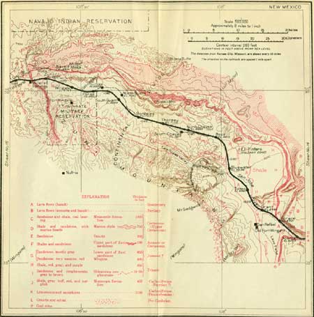
SHEET No. 15 (click on image for an enlargement in a new window) |
|
Horace. Elevation 6,321 feet. Kansas City 1,012 miles. |
Near milepost 90 the beds of rock in the canyon walls begin to rise gradually toward the west, and the Dakota sandstone and underlying beds, including the massive gray sandstone seen near Laguna and Acoma, appear again. These rocks extend along the base of the cliffs far to the north and south of the railway. The rise of the beds continues past Horace siding for 1-1/2 miles to milepost 92, where a sandstone butte north of the track shows the beds dipping eastward at angles between 5° and 10°.
Just north of Horace the sandstone mesa north of the track is 300 or 400 feet high and capped by a thick sheet of older lava (basalt), which extends for a considerable distance east and west. This mesa finally bears off to the northwest as the valley widens, and a corresponding cliff extends south. Four miles west of Horace the valley is several miles wide and the greater part of its bottom is occupied by the very recent lava flow mentioned above.
|
Grant. Elevation 6,464 feet. Kansas City 1,017 miles. |
Grant is a local center for ranch and stock interests in the adjoining region. Just north of Grant is a lava-capped mesa which continues about 5 miles west, gradually bearing off to the north. In places the edge of the lava shows columnar structure. South of the track there are good exposures of the recent lava sheet above referred to, showing a large amount of very rough surface with great broken blister cracks and much ropy lava.
A few miles west of Grant the Zuni (zoon'ye) Mountains are in sight to the west. These mountains are the result of an extensive dome-shaped uplift of the earth's crust. In its higher central part, from which the sedimentary rocks have been removed, the old granites and schists appear, constituting a group of high summits of considerable prominence. One of these, Mount Sedgwick, has an altitude of 9,200 feet. The Zuni Mountains extend westward along the south side of the San Jose Valley and across the Continental Divide nearly to Gallup, the railway deflecting its course somewhat to the northwest to pass around their foothills. Many features of the limestone ridge on the northeast slope of this uplift are visible between Grant and Bluewater stations, including some deep canyons rimmed with high cliffs of the white limestone and sandstone of later Carboniferous age. The northeastward dip is plainly perceptible, and the rough, craggy ridges of granite of the interior of the uplift may be discerned, culminating in Mount Sedgwick.
Northeast of the railway a wide valley extends to the foot of low cliffs of red sandstones and gray sandstones (Dakota), with formations of later Cretaceous age farther back. From a point near Bluewater station there are fine views of the west side of Mount Taylor to the east, showing the high lava-capped plateau on which this mountain stands.
|
Bluewater. Elevation 6,634 feet. Population 237.* Kansas City l,028 miles. |
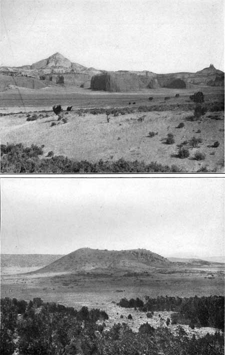
South of Bluewater is a Mormon settlement using water from Bluewater Canyon to irrigate fruits, alfalfa, and vegetables. Three miles north by east of Bluewater station there rises on the valley slope a round black cone of moderate elevation, known as El Tintero (tin-tay'ro, Spanish for ink pot), from the deep hole or crater in its top. It is shown in Plate XVI, B (p. 100). The lava flow flooring San Jose Valley at Horace and Grant extends to this cone, which perhaps marks a source of the outflow. El Tintero is plainly in view to the north of the track for several miles, or nearly to milepost 110, where the lava ceases and is succeeded by red and gray shale of Triassic age. The shale represents some of the red shales and sandstones which overlie the massive sandstone of the middle of the red beds in the Glorieta region, between Las Vegas and Lamy.
A short distance southeast of the railway low knobs mark the outcrop of sandstone (Shinarump?) underlying this shale, and a short distance farther south still lower limestones, of Carboniferous age, rise gradually on the northeast slope of the Zuni uplift.
From milepost 110 to the Continental Divide at Gonzales and thence down the west slope for 20 miles farther the railway is built through a broad valley underlain by the soft red and gray shale above mentioned. This valley extends northward for 2 or 3 miles to the foot of walls of bright-red sandstones (Wingate), mostly 300 to 400 feet high, capped by lighter-colored sandstones (the Zuni and Dakota) which rise as great steps to a ridge of considerable prominence extending continuously across the Continental Divide. This red wall is recessed by numerous small canyons, and some of the intervening buttresses are carved into a great variety of massive forms. These very conspicuous and beautiful features continue in sight for a long distance along the north slope of the Zuni uplift.
The strata appear to be horizontal, but they dip at low angle to the northeast or at right angles to the line of the railway.
Figure 21, a section near the Continental Divide, shows the succession of beds on the slopes of the Zuni Mountains south of the railway and in the walls of red sandstone and overlying rocks to the north.

|
| FIGURE 21.—Section from the Zuni Mountains northward across the Santa Fe Railway near Thoreau, N. Mex., looking northwest. |
|
Thoreau. Elevation 7,135 feet. Population 286.* Kansas City 1,047 miles. Gonzales. Elevation 7,250 feet. Kansas City 1,051 miles. |
In the region about Thoreau the principal industry is the raising of sheep, goats, and cattle. Many Navajo Indians, engaged mainly in goat raising, live in the country to the north. This it is the place from which the extensive prehistoric ruins of Chaco Canyon, 50 miles to the north, are reached. One of these ruins, now called Pueblo Bonito, was a house of about 1,000 rooms. At Thoreau and for the next few miles beyond there are especially fine views of the great cliffs of red Wingate sandstone to the north.
The climb up to the Continental Divide is made on a very moderate grade, about 21 feet to the mile. There is no mountain top to be attained, for the divide is in a broad east-west depression known as Campbells Pass. The summit, which is reached at Gonzales siding, halfway between mileposts 130 and 131, is at an altitude of 7,250 feet, or 358 feet lower than Raton Pass. A large sign erected just north of the track states that the Continental Divide is crossed at this place. This divide, which crosses the Zuni Mountains to the south and passes over the high cliffs to the north, separates the waters of San Jose River and the Rio Puerco, affluents of the Rio Grande, from those of the Rio Puerco (of the West), a branch of the Little Colorado, which flows into the Colorado and so empties into the Pacific Ocean.
West of Gonzales there are two lines as far as Perea; the westbound trains take the left-hand track and pass through South Guam siding, halfway between mileposts 136 and 137. In this vicinity the great red wall to the north is a prominent feature, and to the south rise the long slopes of sandstone and limestone leading up to the wooded summit of the Zuni Mountains. A small ridge, constituting a foothill to these mountains is due to the outcrop of the bed of coarse Shinarump sandstone which lies beneath the shales of the wide valley followed by the railway.
The wall of red Wingate sandstone 2 miles north of Perea siding is broken into numerous massive buttresses, which rise to a high shelf of moderate width extending back to still higher steps of lighter-colored sandstones and shale (the Zuni), capped by the Dakota sandstone far in the background. These features continue in view to Wingate station.
|
Wingate. Elevation 6,743 feet. Kansas City 1,067 miles. |
Wingate is the station for old Fort Wingate, which is 3 miles due south of it. Until recently this fort was sustained by the Government as a military depot, with several regiments ready for active duty. During part of 1914 the old buildings were used for housing the 4,000 Mexican Federal troops and their families who were forced into Texas at Eagle Pass. These people were employed in working roads in the vicinity.
The traveler is here well within the land of the Navajo (nav'a-ho) Indians, now peaceful blanket makers, herders, and farmers, but for along time one of the predatory savage tribes, the terror of the Pueblo people and their ancestors.1
1The Navajos were wily warriors, and usually their raids or other depredations were victorious. After the acquisition of the Southwest by the United States, they killed many citizens, especially when the frontier troops were withdrawn to participate in the Civil War. Several attempts were made to subdue the Navajos, but none succeeded until 1863, when Col. Kit Carson drove them into eastern New Mexico, where they were held as prisoners until 1867. Then they were permitted to return to their old haunts in western New Mexico and northeastern Arizona, where a large reservation was apportioned to them. Since that time they have been peaceful and in some ways prosperous. It is estimated that the warfare against the Navajos and Apaches from 1849 to 1886 cost the United States $50,000,000.
The Navajo Reservation covers more than 9,000,000 acres, most of it above an altitude of 6,000 feet. Its southeastern corner is 20 miles northeast of Wingate, its southwest corner is a short distance west of Canyon Diablo, in Arizona, and it has a length of about 190 miles. This is an area of about 15,000 square miles, which is greater than Massachusetts and New Jersey together. The Navajos number about 30,000. Their number has been steadily increasing for many years; it was 9,000 when they were counted in 1869. They were not mentioned by travelers prior to 1629, and apparently began as a small offshoot of the Apaches. They call themselves Dinneh, meaning "the people." The Spaniards called them "Apaches de Navajo," from Navahu, the name of an old Tigua pueblo in the vicinity of which they lived. Most of them live in temporary hogans, built simply of sticks covered by earth and branches, and they frequently move from place to place. Usually a few families live near together, and they congregate about watering places and trading posts. The women weave their famous blankets, which bring them nearly $500,000 a year, and men and boys tend their sheep and goats and raise a few crops. They live a life closely adjusted to their environment, and with very few requirements beyond the simplest necessities. They own about 30,000 cattle, 1,400,000 sheep, 320,000 goats, and 250,000 horses, burros, and mules. In 1914 they sold 3,375,000 pounds of wool from native sheep, and 293,463 pounds of merino wool, valued in all at $465,000.
Despite their history as predatory savages, the Navajos are in general jovial, truthful, intelligent, and, as Indians go, industrious and capable. They have an ample vocabulary, a complex grammar, an elaborate religious system, and hundreds of songs. They have numerous schools scattered widely over the reservation, and many of them are eager to have their children attend. About 10 per cent have tuberculosis, and 20 per cent have trachoma, a contagious eye affection.
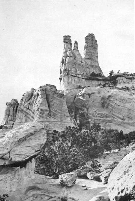
West of Wingate the railway continues along the red shale valley but gradually approaches much nearer to the foot of the great red cliffs than in the region farther east, affording particularly good views of some of their picturesque features. Due north of milepost 150 a remarkable rocky pinnacle, known as the Navajo Church (see P1. XVII), may be seen. Its sharp spires of white sandstone, about 200 feet high, rise conspicuously above the rocky slopes at the top of the walls of red sandstone. It is a striking object, fashioned by the irregular erosion of the massive Zuni sandstone by rain and frost, and in some measure also by wind-blown sand. A short distance to the west is Pyramid Rock (shown in Pl. XVI, A), a conical mass of the same material.

|
|
PLATE XVI.—A (top), PYRAMID ROCK AND RED
CLIFF OF WINGATE SANDSTONE NORTH OF ZUNI SIDING, A FEW MILES EAST OF
GALLUP, N, MEX. View northeastward. Navajo Church at extreme right.
Santa Fe Railway in middle distance. B (bottom), EL TINTERO, A VOLCANIC CONE WITH A CRATER IN ITS TOP, THREE MILES NORTHEAST OF BLUEWATER STATION, N. MEX. View northeastward over fields of lava ejected from a vent at this place. |

|
| PLATE XVII.—NAVAJO CHURCH, NORTHWEST OF WINGATE, N. MEX. Carved by rain and wind-blown sand in white Zuni sandstone. Note cross-bedding. |
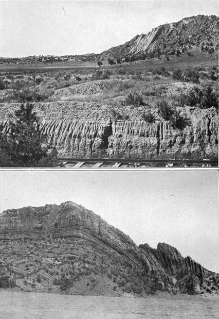
Not far west of Zuni siding (milepost 152) the axis of the arch of the Zuni uplift is crossed, the beds on its crest pitching steeply to the northwest. West of the axis the beds all dip steeply to the west and southwest. This feature may be observed between mileposts 153 and 155, especially at the latter, where the railroad and creek pass through a narrow gap having walls of nearly vertical beds of the Dakota and overlying sandstone, as shown in Plate XVIII. This steep dip to the west carries these sandstones underground within a short distance, beneath coal-bearing sandstones that occupy a shallow basin to the west. (See Pl. XIX, A.) The change of dip from nearly vertical to horizontal is so rapid as to give the appearance of a fault in the slope north of the railway, but close scrutiny has shown that there is no appreciable break. The relations of this flexure are shown in figure 22.

|
| FIGURE 22.—Section of coal-bearing Mesaverde formation, Dakota sandstone, and underlying beds in and near the gap 3 miles east of Gallup, N. Mex. |

|
| PLATE XVIII.—TILTED BEDS OF SANDSTONE DIPPING WEST ON WEST SLOPE OF ZUNI UPLIFT, THREE MILES EAST OF GALLUP, N. MEX. View southward. Valley of Mancos shale to the right. |

|
|
PLATE XIX.—A (top), SHARP BEND IN BOUNDARY
OF ZUNI MOUNTAIN UPLIFT AS SEEN FROM SANTA FE RAILWAY THREE MILES EAST
OF GALLUP, N. MEX. View northward. Nearly horizontal coal measures
(Mesaverde formation) at left of center of view, in background. B (bottom), GREAT ARCH IN THE RED SANDSTONE NORTH OF HOUCK, ARIZ. View northward. |
The narrow zone of steep dips extends all along the west side of the Zuni uplift, and the ridge marking its course may be seen bearing off to the south from the vicinity of milepost 156. The basin west of this uplift contains an extensive area of sandstones and shales of later Cretaceous age (Mesaverde), including several beds of excellent subbituminous coal which are worked at a number of places.
|
Gallup. Elevation 6,503 feet. Population 2,204. Kansas City 1,079 miles. |
Gallup is a railway division point and meal station. Its principal industry is coal mining and most of the mines are in the immediate vicinity of the town.l There are also two brick kilns that make a large output. Many cattle, sheep, and goats are raised in the adjoining country. A large number of Navajo and Zuni Indians come to Gallup to trade and each year bring in an increasing amount of wool for sale. Formerly they received their pay in merchandise, but now the clip of wool is so large that they receive considerable balances in cash. The Navajo Reservation is a short distance north of Gallup and 40 miles to the south is Zuni, one of the largest pueblos in the Southwest. This place is visited by many persons and is easy of access by vehicles from Gallup over fairly good roads. At Zuni there are ample facilities for taking care of visitors overnight. A special occasion is the Shalako dance, usually held in November.
1The coal that is extensively mined about Gallup is a subbituminous coal (formerly known as black lignite), which occurs mainly in a bed 5-1/2 feet thick, contained in the Mesaverde formation. It is used on locomotives and shipped great distances along the railway for manufacturing and domestic use. Its keeping qualities, however, are not entirely satisfactory, the coal having a disposition to break up into fine slivers when exposed to the air, on account of the large amount of water it contains. The rapid evaporation of this water from the surface layers causes them to shrink and curl up or scale off and to heat spontaneously when stored for a long time in large quantities. Eventually it will be compressed into briquets, a result which will overcome these unfavorable characteristics. The average Gallup coal contains about 42 per cent of fixed carbon, 40 per cent of volatile combustible matter, 11 per cent of moisture, and 6 per cent of ash. The heating value is 11,700 British thermal units. In 1913 the production of coal from the Gallup region amounted to nearly 825,000 tons, valued at $1,367,364. The coal-bearing series consists of an alternation of sandstone and shale. Ledges of sandstone crop out extensively around Gallup and for some distance west.
Zuni is one of the famous seven cities of Cibola, the objective point of the Spanish expedition under Coronado in 1540. The largest of these seven pueblos contained about 500 rooms. Some of the ruins of old Cibola are still to be seen. Near Zuni is the precipitous-sided mesa of Toyalane, to which the Indians of this tribe fled whenever they feared invasion or punishment, remaining there sometimes for many years, while their abandoned pueblos fell to ruins. The present pueblo of Zuni was built 200 years ago, and here was concentrated what remained of the people of Cibola. The United States has recently built a dam to hold water for irrigation at Zuni, an undertaking which is greatly appreciated by these progressive and prosperous Indians. Their population, which is 1,640, has remained about the same for the last 30 years.
At Gallup a large supply of excellent water is obtained from artesian wells sunk through the coal-bearing rocks into the underlying sandstones. Without this underground supply the town would be greatly hampered, for the surface waters in the vicinity are very small in volume and mostly of bad quality. The well water is carried in tank cars to supply many stations along the railway where the local water is not satisfactory.1
1The first wells at Gallup were not very deep and obtained only a moderate volume of water, but on the advice of a geologist of the United States Geological Survey deeper borings were made with great success. Several other wells have been sunk at places on this railway on similar advice and important water supplies obtained. The study of the conditions under which waters occur underground is a branch of geologic investigation requiring the determination of the succession and structure of the water-bearing rocks and their associated beds.
| <<< Previous | <<< Contents >>> | Next >>> |
bul/613/sec15.htm
Last Updated: 28-Nov-2006