
|
Geological Survey Bulletin 613
Guidebook of the Western United States: Part C. The Santa Fe Route |
ITINERARY
|
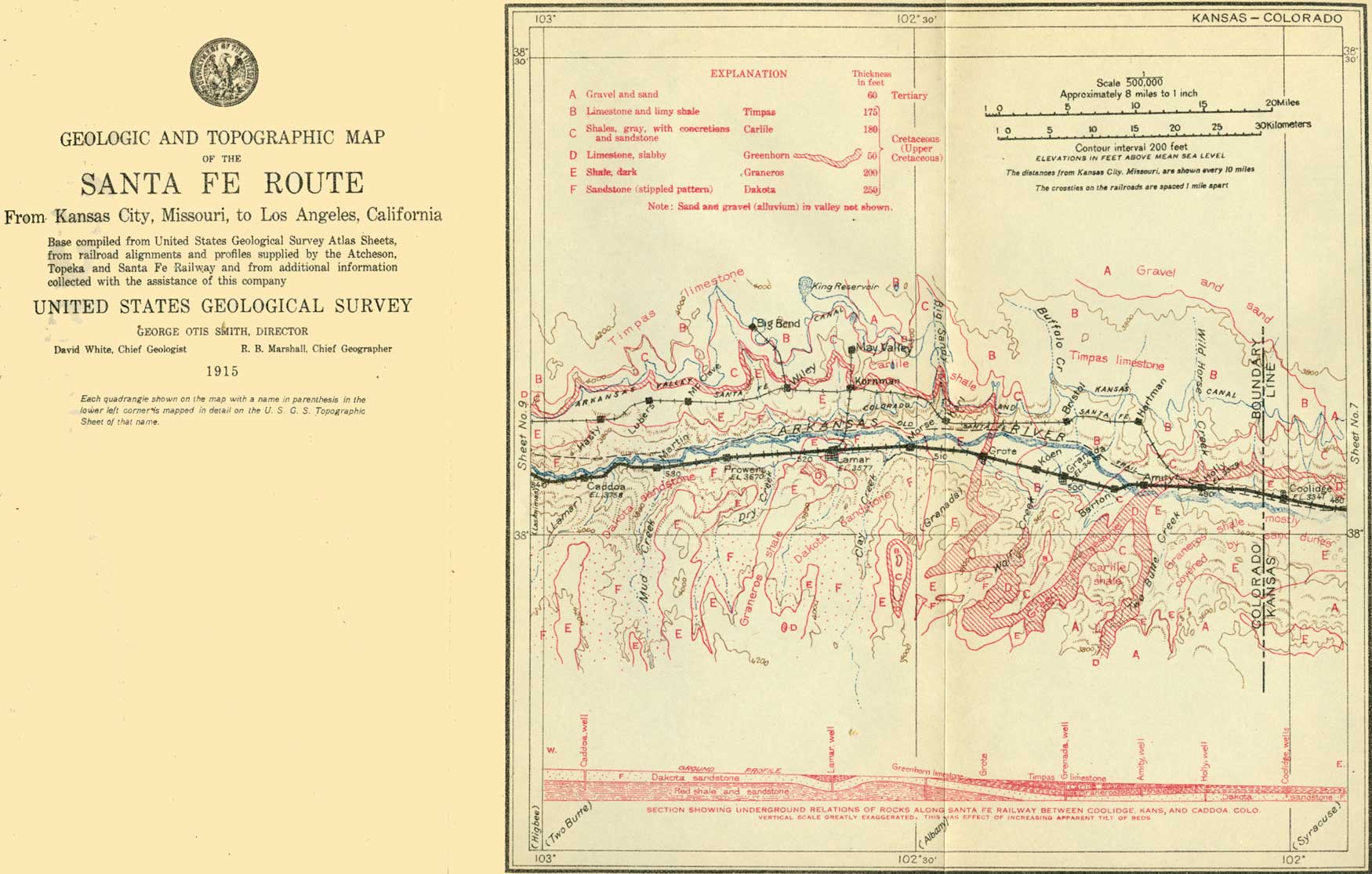
Coolidge, Kans. Elevation 3,341 feet. Population 145. Kansas City 484 miles. |
East of Coolidge (see sheet 8, p. 48) and for a short distance west of it there are scattered ledges of Greenhorn limestone along the foot of the slope on the north side of the valley, but most of the slopes are gentle and grass-covered, as the rocks arc too soft to form prominent bluffs.
Coolidge was named for T. J. Coolidge, a former president of the Santa Fe Railway Co. It is near the eastern limit of the Arkansas Valley artesian area, in which flowing wells are obtained along the bottom lands nearly as far west as the foot of the Rocky Mountains. The artesian condition ends on the east because finally, through leakage of water to the surface, the head becomes too low to afford a flow.
The State line between Kansas and Colorado is crossed six-tenths of a mile beyond milepost 470.
|
|
SHEET No. 8 (click on image for an enlargement in a new window) |
| Colorado. |
Colorado has an area of 103,948 square miles and contains varied physical features and many natural resources. Its eastern part lies on the higher portion of the Great Plains, and its western part includes a broad area in the higher portion of the Rocky Mountains. Numerous rivers afford water for irrigation, by which large crops are produced in many districts; the mountains have productive mines of gold, silver, and other metals; thick beds of coal occur in several regions; and wide areas are utilized for stock raising. More than 200 of the mountain peaks in central Colorado are higher than 13,000 feet above the sea, and 40 are over 14,000 feet. The highest are Elbert and Massive mountains, in Lake County, each of which rises 14,402 feet.
When the early Spanish explorers passed through Colorado they found no people, but ruins of many habitations. Lieut. Pike discovered the Rocky Mountains in 1806 and Col. Long visited them in 1820. Frémont crossed this range in the northern part of the State in 1843. Part of the area was included in the Louisiana Purchase, part was included in the Republic of Texas, and the remainder was ceded by Mexico in 1848. Settlement began in 1858, when the discovery of gold at Platte River, near the site of Denver, drew a large tide of immigrants. The Territory of Colorado, which was organized in 1861, included portions of Kansas, Nebraska, New Mexico, and Utah. The Civil War and depredations by Indians greatly retarded its development, but in 1876 the State was admitted to the Union. In 1910 the population was 799,024 and the density 7.7 to the mile, or nearly twice as great as in the census of 1890.
|
Holly, Colo. Elevation 3,379 feet. Population 724. Kansas City 490 miles. |
Holly is a center for ranch and cattle interests. Three-quarters of a mile to the west, on the north side of the track, is a large beet-sugar factory, utilizing the sugar beets which are raised by irrigation in adjacent portions of the valley. The Santa Fe Trail passed through this place and its location is marked by a granite monument opposite the station. A short distance to the south is an old stone building built in 1873 for protection against Indians. In the vicinity of Holly, and thence to Amity, the valley slopes present few rock outcrops excepting occasional ledges of nearly horizontal beds of Greenhorn limestone.
|
Amity. Elevation 3,410 feet. Kansas City 495 miles. |
The village of Amity was created by the industrial division of the Salvation Army for the purpose of giving outdoor work to a colony of 250 persons connected with that organization. It was started as "Fort Amity" in 1898, with a tract of 1,800 acres. Considerable land has been cultivated, mainly for the production of sugar beets to send to the factory at Holly. The broad alluvial flats along the north side of the river are especially suited to the cultivation of this plant, which is irrigated by water brought in canals from higher up the valley. This industry is increasing, and now there are six factories between Pueblo, Colo., and Garden City, Kans., that have a total capacity of about 5,000 tons of beets a day.
Just beyond milepost 480 the railway crosses Arkansas River, to continue on the south bank to La Junta. A branch, however, intended for local service in the valley, especially in connection with the sugar-beet industry, leaves the main line at Holly and follows the north slope of the valley as far as Rocky Ford, famous for its cantaloupes. In the Colorado portion of the Arkansas Valley, which the railway follows to La Junta, about 205,000 acres is irrigated from the river, and there are many ditches for distributing and several large reservoirs for storing water.1 Fruit, grain, vegetables (including 27,350 acres of sugar beets), and forage crops are the principal products.
1The mean discharge of the Arkansas at La Junta, determined by gagings by the United States Geological Survey, is 338 second-feet—that is, cubic feet a second. In dry times the flow diminishes to less than 10 second-feet, and at times of flood it has exceeded 10,000 second-feet.
|
Granada. Elevation 3,438 feet. Population 359. Kansas City 501 miles. |
Granada is built near the site of the great cattle depot of Trail City in the days of the Santa Fe Trail. Here one of the principal trails from Texas reached the river and large numbers of southern cattle were delivered to herders, who drove them to the northern ranches. In this vicinity the river is in a wide valley, with level floor and long slopes rising on each side to the table-lands of the Great Plains. The railway is on the alluvial deposits, only a few feet higher than the river. In the adjoining slopes are outcrops of various rocks of the Cretaceous period. The relations of these rocks are shown in the section on sheet 8 (p. 48). The beds form a basin-like sag in the vicinity of Granada, so that the Greenhorn limestone lies several hundred feet deep, and the overlying shales and limestones constitute the surface. These shales (the Carlile), about 200 feet thick, together with the overlying limestone (the Timpas), crop out in low bluffs a short distance south of Granada, as well as in the slopes on the north side of the valley. The limestone is quarried to some extent for building stone and lime. It is soft and chalky and is very similar to the Greenhorn limestone in most respects, but occurs in somewhat thicker beds.1 A 1,000-foot well at Granada obtains water from the Dakota sandstone, underlying the Graneros shale, but the pressure is not great enough to afford a flow, as in the many borings farther up and down the valley.
1The Timpas limestone contains impressions of shells and large numbers of Foraminifera, showing that it was deposited by the sea under conditions very similar to those which prevailed during the time of the deposition of the Greenhorn limestone.
There is in this succession of limestone and shale formations an interesting chapter in geologic history, the Graneros and Carlile shales consisting of deposits from muddy water and the Greenhorn and Timpas limestones consisting of deposits from waters containing but little clay or sand in suspension. These conditions were widespread over a great extent of the plains country east of the Rocky Mountains, for this repeated alternation of shale and limestone is general throughout the area. During this time there was a great variety of life in the waters, as shown not only by large numbers of shells but remains of fish and reptiles, especially in the Niobrara beds. A restoration of one of the most remarkable creatures is shown in Plate V, B. This restoration was based on bones found in the Niobrara rocks in western Kansas.

|
|
PLATE V.—A (top), MESAS OF TIMPAS LIMESTONE,
BLOOM-THATCHER REGION, COLO. Below the limestone caps are slopes of
shale (Carlile) to a wooded bench of Greenhorn limestone. Dakota
sandstone forms foreground. B (bottom), TYLOSAURUS. A mososaur, or great marine lizard, from the chalk beds of the Niobrara formation in western Kansas. Restoration by C. R. Knight. |
|
Grote. Elevation 3,486 feet. Kansas City 507 miles. |
West of Granada the rocks rise gradually. In the vicinity of Grote siding the Greenhorn limestone comes up again, although near the river it is covered by the alluvial deposits which floor the valley. Near milepost 496 the Dakota sandstone reaches the surface, and except for a short distance at Lamar it appears all along the lower portion of the valley slopes to Las Animas and beyond. The structural relations of the strata which result in the cropping out of the Dakota sandstone are shown in the section on sheet 8.
Between mileposts 495 and 496 there is a long railway cut 5 to 10 feet deep, through loam with interspersed beds of bowlders, gravel, and sand of the alluvial deposits that floor the valley and constitute a terrace slightly higher than the river flat to the east and west. The material was deposited by the river a few thousand years ago, and the variations in coarseness and texture were caused by alternations of swifter and slower currents, the former bringing coarse materials and the latter depositing silt and sand. Changes of channel are frequent in Arkansas River, as in many other large streams. A notable illustration of such a change is visible halfway between mileposts 496 and 497, where a new channel has been cut by a recent flood.
|
Lamar. Elevation 3,577 feet. Population 2,977. Kansas City 518 miles. |
Lamar, the seat of Prowers County, was named for L. Q. C. Lamar, a former Secretary of the Interior. It has extensive agricultural and cattle interests in the surrounding country. Besides several mills and factories, the town has a large milk-condensing plant, supplied by many dairy farmers in the vicinity. In 1914 the milk of 2,000 cows was being condensed. There is also a beet-sugar factory here, but of late it has not been in operation because the farmers in this vicinity have come to the conclusion that beet raising is not sufficiently profitable for them. Bees are kept in large numbers, and honey is an important local product.
Very few rocks are visible in the vicinity of Lamar, although ledges of the Dakota sandstone appear in some of the slopes southeast of the town and at many places farther west along the valley. This rock becomes conspicuous in the river bluffs at Prowers and west of that place on both sides of the stream. It is exposed along or near the railway from milepost 509, 1-1/2 miles east of Prowers, nearly to Las Animas. Near milepost 520 the railway cuts expose shale, which separates some of the beds of Dakota sandstone at most localities. The predominant features of the formation, however, are the cliffs of massive coarse gray sandstone. This material is used to some extent as a building stone, although much of it is too slabby or irregular in texture or color to be of any great value for that purpose.
|
Caddoa. Elevation 3,758 feet. Population 329.* Kansas City 537 miles. |
Caddoa derives its name from the linguistic family of which the Pawnee and Wichita Indians of this vicinity were branches. Here the immediate river valley is narrow, bluffs of Dakota sandstone rising from the alluvial flat near the stream on both sides. To the north these bluffs are surmounted by an irregular terrace covered with gravel and sand, and to the south they are interrupted by sandy slopes partly occupied by dunes. A well at Caddoa, bored 582 feet deep, passed through the Dakota sandstone but did not obtain a very satisfactory water supply in its lower portion, and the water did not have sufficient pressure to come to the surface.
| <<< Previous | <<< Contents >>> | Next >>> |
bul/613/sec8.htm
Last Updated: 28-Nov-2006