
|
Geological Survey Bulletin 614
Guidebook of the Western United States: Part D. The Shasta Route and Coast Line |
ITINERARY
|
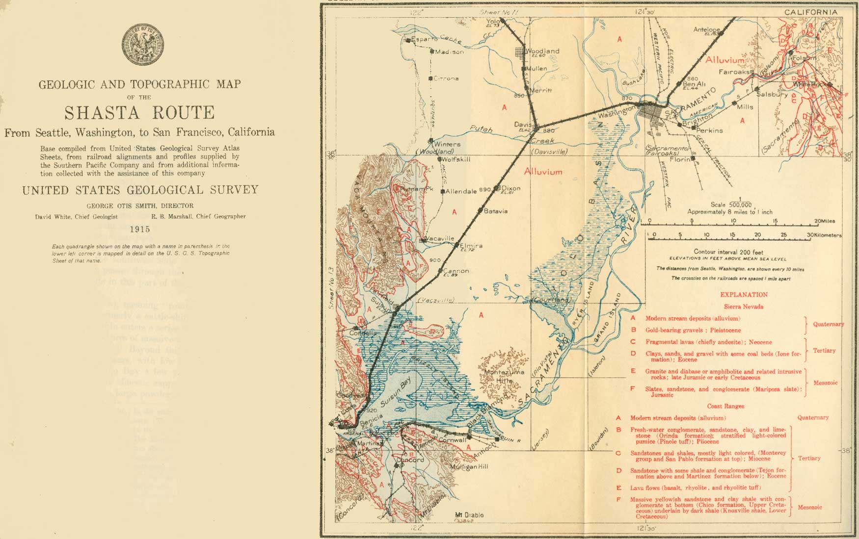
| SHEET No. 12 (click on image for an enlargement in a new window) |
|
Woodland. Elevation 60 feet. Population 3,187. Seattle 845 miles. |
Woodland (see sheet 12, p. 80) is the seat of Yolo County and one of the oldest and richest towns in the valley. Irrigation was begun here in 1856 by diversion from Cache Creek through the Moore ditch. The system is now controlled by the Yolo Water, Light & Power Co., which irrigated 23,000 acres in 1913. In that year about 7,000 acres east and north of Woodland were planted to sugar beets.
|
Davis. Elevation 42 feet. Population 750.* Seattle 854 miles.1 |
From Woodland the railroad passes through a rich farming region to Davis, where the Shasta Route joins the route from Omaha by way of Ogden and Sacramento to San Francisco. To the east is the level expanse of Yolo Basin, where yearly flooding prevents the growth of all except tule (Scirpus lacustris) and coarse grasses. To the west may be seen the low, reddish hills of older alluvium. Near Davis is the large farm of the University of California used for experimental and educational purposes. The country in this vicinity is an almost flat plain near sea level, but nevertheless high enough to provide drainage. With its rich fields of grain and orchard patches it has a decidedly prosperous look. Beyond Davis the Coast Range becomes more prominent, especially to the right, ahead of the train, showing as a low, dark ridge broken by one or more gaps. Valley and live oaks are again a common feature through the fields.
1By way of main line; 881 miles by way of Marysville branch.
Along the Pacific coast, from the vicinity of Santa Barbara on the south to Humboldt County on the north, the Coast Ranges divide the Great Valley of California from the ocean. They are broken by the one great gap by which the comnbined Sacramento and San Joaquin rivers find outlet into the Bay of San Francisco. The Coast Ranges are geologically the most recent of the great structural features of the State. They are largely built up of folded and crushed Cretaceous, Jurassic, and Tertiary sedimentary rocks, which are in places broken through by andesitic and basaltic lavas and by older igneous rocks (diabase and other dark, heavy rocks, in part altered to serpentine).
|
Dixon. Elevation 61 feet. Seattle 889 miles.1 |
Dixon is an agricultural town in Solano County. Beyond it the Coast Range now looms larger as the traveler proceeds westward. Elmira (elevation 79 feet), a junction whence a branch road goes to Vacaville, Winters, and Rumsey, is next passed. Elmira the road Beyond approaches low foothills of the Coast Range—first a bare ridge, with gaps, through one of which the railroad passes over a slight rise. The factory of the Pacific Portland Cement Co. and adjacent shale quarries can be seen to the north. The limestone used here to mix with the shale is brought from a point near Auburn.
1Distances for stations from Dixon to San Francisco given by way of Marysville line; to get distance actually traveled by main line through Woodland deduct 27 miles.
The traveler coming across the Sacramento Valley in the day during midsummer is likely to find the trip warm, but on reaching this gap in the Coast Range he almost invariably notices a change. The cool breezes sweeping in from the west and carrying the smell of the salt marshes become fresher as the train proceeds, and it is a reasonable precaution to have wraps handy from this point on.
Beyond the first spur of the Coast Range the valley again broadens. Higher mountains, more or less darkened by scrubby timber on their upper slopes, border the valley to the north and far to the south. If the air is moderately clear, Mount Diablo2 and the southern continuation of the Coast Range may be seen. A group of low, round, and grassy hills a few miles to the south are known as the Potrero Hills. (Potrero, pronounced po-tray'ro, is Spanish for horse pasture.)
2The general outline and isolated position of Mount Diablo have given the impression that this mountain is an old volcano. It represents, however, the higher portions of an overturned arch or anticline of sedimentary rocks thrust from the northeast toward the southwest. From its summit to the sea level at Carquinez (car-kee'ness) Strait is displayed a remarkably complete series of typical Coast Range formations, including Franciscan, Knoxville, Chico, Martinez, Tejon, Mo terey, San Pablo, late Tertiary freshwater beds, Pleistocenes and Recent. Although Mount Diablo is of moderate height (3,849 feet), its isolation and its situation on the edge of the Great Valley make it one of the finest viewpoints in the State. From its top, on a clear morning, the summits of the Sierra Nevada can be traced for over 200 miles. Lassen Peak is often visible and sometimes Mount Shasta. The Great Valley appears divided into squares like a checkerboard by the section-line roads and fences. The San Francisco Bay region is sometimes hidden by a snowy sea of fog. The mountain is easily reached from San Francisco, though at present the ascent must be made on foot or by driving. The road, which goes practically to the summit, will probably be fitted for automobile travel.
|
Suisun. Elevation 15 feet. Population 641. Seattle 909 miles. |
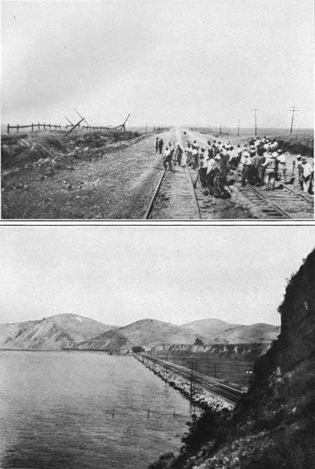
Suisun (suey-soon', locally soo-soon', the name of an Indian tribe, said to mean great expanse) and the adjoining town of Fairfield (the seat of Solano County, population 834) are at the edge of another swampy district green with tule. From this point the railroad is graded across the Suisun Flats, which are so near tidewater level in Suisun Bay, to the south, that no cultivation is possible under present conditions, though the camps of several duck-shooting clubs are situated among the sloughs. The railroad formerly encountered much difficulty in maintaining its grade across this soft ground. Certain spots sank continually ever since the first construction of the road, and it was seldom that in going over this part of the route the traveler did not see work trains and grading crews busily engaged in filling and raising some sunken portion of the track. (See Pl. XXIV, A.) Mud ridges rose along the tracks on both sides, and their broken and lumpy surfaces indicated a slow flowing mass of mud squeezed out by the weight and vibration of passing trains. It is said that as much as 30,000 carloads of coarse gravel ballast was dumped into one of these spots.
|
|
PLATE XXIV.—A. SINKS OF SUISUN FLATS,
CAL. Railroad crew at working raising and regrading a recent sink. Note upward-building mud ridge on each side and tilted telegraph poles on the left. B. VIEW ALONG THE SHORE OF SAN PABLO BAY NEAR OLEUM, CAL. Terrace in middle represents rained beach that can be seen at several points around San Francisco Bay. |
Beyond the marshes the railroad meets the rocky headlands that here close in upon Carquinez Strait. Some fine exposures of Cretaceous and Tertiary sandstones and shales may be seen in the cliffs and road cuts around Army Point.
|
Benicia. Elevation 6 feet. Population 2,360. Seattle 921 miles. |
Near Benicia, on the left, is a United States arsenal and signal station. Benicia (named by Gen. Vallejo after his wife) is a manufacturing town with deep-water frontage. It contains, besides the arsenal, tanneries and other commercial establishments. Southeast of Benicia, across the strait, is the town of Martinez near which John Muir, California's great naturalist, lived for many years. The tall smokestack east of the town belongs to the smelter of the Mountain Copper Co., which mines its ore near Kennett, in Shasta County. At this smelter sulphur fumes are utilized in making sulphuric acid, which in turn is used in treating rock phosphate brought from the company's mine near Montpelier, Idaho, and here turned into fertilizer. Just beyond Benicia the train is run onto a ferryboat and is carried across Carquinez Strait to Port Costa, a distance of a mile.
The geologic section from Benicia and Port Costa to the vicinity of Berkeley and Oakland is particularly interesting, as in it are represented many of the characteristic sedimentary formations of the Coast Range. The stratigraphic section is quite different from that of corresponding age in the Sierra foothills.
| <<< Previous | <<< Contents >>> | Next >>> |
bul/614/sec12.htm
Last Updated: 8-Jan-2007