
|
Geological Survey Bulletin 614
Guidebook of the Western United States: Part D. The Shasta Route and Coast Line |
ITINERARY
|
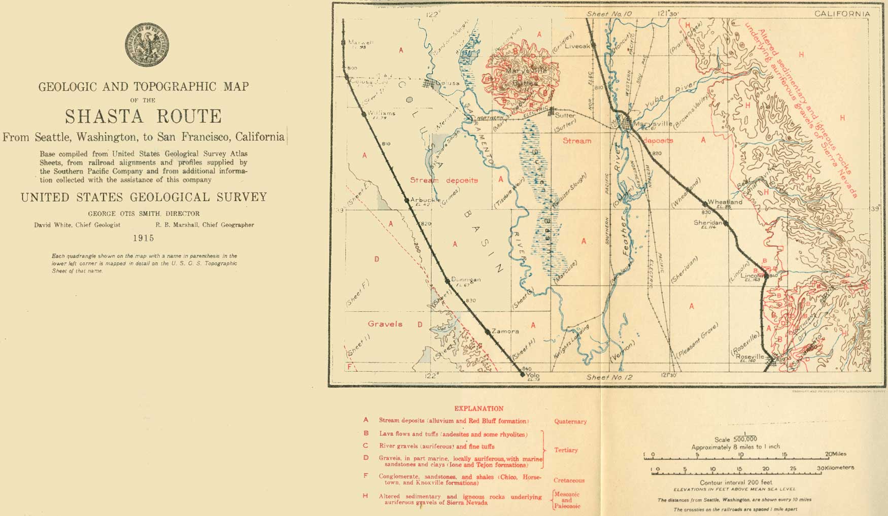
| SHEET No. 11 (click on image for an enlargement in a new window) |
|
Maxwell. Elevation 93 feet. Population 864.* Seattle 798 miles. |
Beyond Maxwell (see sheet 11, p. 76), an old village of the grain farming days, is Colusa Junction, where the Shasta Route crosses the Colusa & Lake Railroad. This line runs from Colusa, on Sacramento River, westward to Sites, in Colusa County. At Sites is the sandstone quarry that furnished the material for the Ferry Building in San Francisco. Twenty miles east of Maxwell the rugged Marysville Buttes rise abruptly from the plain, forming a landmark that can be seen for many miles in all directions.1
1The Marysville Buttes are a cluster of hills about 10 miles in diameter, culminating in South Butte, 2,132 feet above sea level. North Butte has an elevation of 1,863 feet. The central area, about 4 miles in diameter is composed of andesite, a lava that was pushed up from the interior of the earth in a molten but stiff condition. Around the andesite is an irregular belt of sandstone and shales of Tertiary age, bent upward by the force of intrusion of the andesite so that they dip away from the center at angles of 18° to 90°. An outer belt, about 2 miles wide, of tuffaceous breccias, consisting of angular fragments of lava of various sizes with some pebbles of other rocks, surrounds the sandstone and shales. The material of these breccia beds probably once flowed from the crater of the volcano as a thick stony mud. The streams flowing down from the buttes have broad valleys which are filled with alluvium in their lower courses. The hills have an outer slope of 250 feet to the mile and a steeper in-facing scarp or bluff. A projection of the outer slope to the center would restore the outline of the old volcano, making it about 5,000 feet high, or over twice the present height.
|
Williams. Elevation 79 feet. Population 1,463.* Seattle 806 miles. |
The land near Williams is outside of the area served by the Sacramento Valley Irrigation Co.'s ditch, and the local farmers pump their own water. Several pumping plants may be seen south of the town. To the east is the Colusa Basin, a shallow trough which parallels the river as far south as Knights Landing, east of Zamora station. When the levees along the river break this basin is flooded and forms a veritable inland sea from Colusa to Knights Landing Ridge.
West of Williams the bench of older alluvium becomes wider and more prominent and extends in a southeasterly direction to Yolo. North of the village this little plateau is about 400 feet above sea level and covered with a scanty growth of oaks. The streams flow across the plateau or bench at right angles to the trend of the bluff that separates it from the present flood plain of the river and have cut through the alluvium into Cretaceous sandstone and shales that dip toward the valley. The older alluvium rests on the eroded edges of these beds. The bluff in this locality is a fault scarp; that is, it marks a line of faulting. This fault extends from Williams south eastward to Cache Creek and there turns south to Putah Creek.
The Coast Range west of Williams is a greatly crushed and faulted mass of Jurassic and Cretaceous rocks.
|
Arbuckle. Elevation 42 feet. Population 1,249.* Seattle 817 miles. Dunnigan. Elevation 67 feet. Population 333.* Seattle 827 miles. |
From Williams the road rises about 63 feet to Arbuckle, situated on a fan-shaped deposit of recent alluvium supplied by the dissection of the earlier Pleistocene plateau. The principal industry here is almond growing.
At Harrington a branch road, called the Beet Line, turns off to Grimes and Colusa. The line between Colusa and Yolo counties is crossed at Hershey station. Dunnigan, the next village, lies close under the escarpment of the plateau, which is here dissected by streams into rounded hills. On this land are grown wheat and barley, and the skill of the farmers in taking traction engines and combined harvesters over these hills is remarkable. Notwithstanding the recent changes in agriculture previously noted, the great staple product of the Sacramento Valley is still grain. There are grain warehouses at nearly every station, and the traveler can not fail to realize that he is passing through one of the greatest wheat regions of the world. Near Dunnigan a newer industry is seen in thousands of acres planted with eucalyptus trees.
|
Zamora. Elevation 50 feet. Population 292. Seattle 835 miles. Yolo. Elevation 73 feet. Seattle 840 miles. |
At the village of Zamora (Blacks Station post office), the plain between the hills and Colusa Basin is very narrow and backwater from the tule land has been known to come within 1-1/2 miles of the village. This is a country of fine oaks.
From Zamora the railroad rises about 30 feet to the village of Yolo on Cache Creek. This stream leaves the Coast Range through Capay Valley at Esparto and, crossing the plateau of older alluvium, here 10 miles wide, cuts through the escarpment in a terraced canyon 3 miles west of Yolo. From this point it begins to deposit sediment brought from the mountains. In past time Cache Creek has built up a considerable area of country around Yolo and Woodland by means of a number of branches. One of these old branches, called Cache Creek Slough, extends northeastward from Yolo to Knights Landing on Sacramento River. The sediment deposited by it has formed the Knights Landing Ridge, an elevation hardly discernible to the eye, which separates the Colusa Basin from a similar depression to the south known as the Yolo Basin. The fertile soil of the Yolo Basin is underlain by coarse gravel from which large supplies of ground water are obtained.
The largest pumping plant in the valley, the St. Louis plant of the Sacramento Valley Sugar Co., is near Yolo. It consists of 12 wells connected with an electrically driven 15-inch centrifugal pump having a capacity of 7,000 gallons a minute. From this plant 1,200 acres were irrigated in 1913.
| <<< Previous | <<< Contents >>> | Next >>> |
bul/614/sec11.htm
Last Updated: 8-Jan-2007