
|
Geological Survey Bulletin 614
Guidebook of the Western United States: Part D. The Shasta Route and Coast Line |
ITINERARY
|
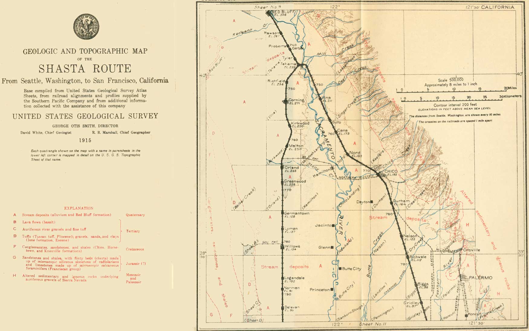
| SHEET No. 10 (click on image for an enlargement in a new window) |
|
Red Bluff. Elevation 308 feet. Population 3,530. Seattle 733 miles. |
Red Bluff (see sheet 10, p. 74), a thriving town, is the seat of Tehama County. It takes its name from the adjacent river bluff, about 50 feet high, in which is exposed a fine section of the sands and gravels of the older alluvium (Red Bluff formation), bowed up by the Red Bluff arch. The town is the head of navigation on on Sacramento River and a supply point for a large area of farming and stock country. It is at the northern limit of the citrus belt, and oranges, lemons, almonds, and figs are raised here, but more attention is paid to peaches, pears, and prunes.
|
Side trip to Lassen Peak nnd
Cinder Cone. |
The Lassen Peak region and the great volcanic plain west of it may be most easily reached from Red Bluff during the summer by automobile or stage to Mineral, Morgan Springs, or Drakesbad, by way of the Red Bluff-Susanville stage road. From these places trails lead to the mountain. The trail from Mineral passes Soupan Hot Springs and the boiling mud pots and sulphur-lined fumaroles at the head of Mill Creek. At Morgan Springs there are hot-spring baths, and the trail from this place passes Bumpass Hell, a vigorous solfatara. Near Drakesbad are the Geyser, a large boiling spring; Tartarus Lake, a boiling mud lake of 3 acres, encircled by fumaroles and boiling springs; and the Devil's Kitchen, an area of solfataras. Warner Creek runs directly through the Devil's Kitchen, so that a fisherman may catch and cook his fish from the same stand. Cinder Cone, the work of a recent volcanic eruption, is within a day's reach. It has been made a national monument.
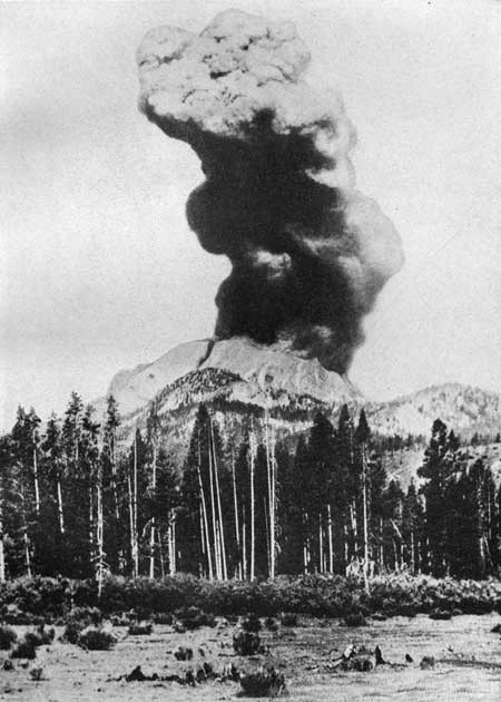
Lassen Peak, from which since May 30, 1914, there have been many eruptions, may be easily reached by trail from Drakesbad. The character of its outbursts is shown in Plate XXII (p. 72), and its new crater in Plate XXIII. The enormous rolling cloud which rises above the crater during an eruption and which is plainly visible from the railroad is composed of rock fragments, rock dust, and steam, with perhaps other gases. No fresh lava has issued from the crater. dust and fragments blown out by the explosive action of the hot gases are derived from the older solid lava through which these gases have burst their way. The opportunity to observe a vigorous volcanic eruption in safety from a railroad train is itself a rare one, and the obstacles to a nearer approach need daunt no one who is willing to travel by stage and put up with simple accommodations. Drakesbad may be reached by automobile not only from the west by way of Red Bluff but also from the east by way of Westwood, on the Southern Pacific, or Keddie, on the Western Pacific.
|
|
PLATE XXII ERUPTION OF LASSEN PEAK, CAL., AT 12.30 P. M.
AUGUST 22, 1914. As seen from Lee's ranch, in Warner Valley, 5 miles southeast of Drakesbad and 12 miles southeast at Lassen Peak. The column of smoke is about 6,000 feet is height. Photograph copyrighted by Thompson, Susanville, Cal. |
|
|
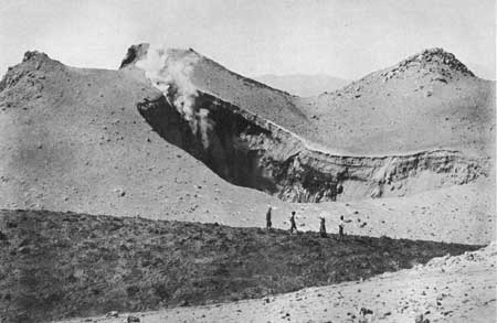
PLATE XXIII.—NEW CRATER OF LASSEN PEAK, CAL., AFTER
25 ERUPTIONS WITHIN THE OLD CRATER, AUGUST 17, 1914. The banded material on the farther rim of the new crater has been thrown out by the recent eruptions and covered a layer of snow. The dark material in the foreground is a snowbank covered with 3 inches of wet dust. Photograph copyrighted by Thompson, Susanville, Cal. |
Tuscan Springs, a health resort 9 miles northeast of Red Bluff may be reached by daily stage. The springs, which are hot, rise in a small area of Upper Cretaceous shales (Chico) surrounded by a large mass of volcanic tuff thrown out from the volcanoes of the Lassen Peak region.
|
Proberta. Seattle 740 miles. |
At Proberta the railroad approaches the top of the bluff which limits the flood plain of the Sacramento on the west. The route continues along the bluff to Gerber. The Kimball Plains, about 12 miles wide, lie to the right (west). Below, to the left, in the fertile river bottoms, may be seen hop and alfalfa fields irrigated by water pumped from wells.
|
Gerber. Seattle 741 miles. |
Gerber will soon succeed Red Bluff as the division point for this portion of the route. Here the train descends into the river bottoms and, passing through green alfalfa fields, crosses Elder Creek before entering Tehama. On Elder Creek, about 20 miles west of this point, is exposed a famous section of Cretaceous rocks 29,000 feet in thickness. This great body of Cretaceous strata is inclined eastward, extending beneath the later formations that fill the Sacramento Valley on the east and lapping up against the Coast Range, which is made up mainly of older rocks on the west. The tilted Cretaceous rocks are beveled by erosion, and their edges form a broad terrace or plain along the western border of the Sacramento Valley at the foot of the Coast Range.
|
Tehama. Elevation 223 feet. Population 221. Seattle 744 miles. |
The town of Tehama is about half a mile east of the railroad station and is the oldest settlement in the county. The soil hereabouts is rich, but the country is occasionally overflowed. A wagon bridge crosses the river to the green irrigated alfalfa fields of the new colony of Los Molinos (mo-lee 'nos). Here may be seen good examples of the beautiful oaks characteristic of valley scenery in California. Tehama is on the later alluvium, but beyond it the line ascends again to the gravel plain of the reddish older alluvium. From Tehama the Marysville line turns off to the left, crosses the Sacramento, and goes south on the east side of the valley. The main line continues down the west side of the valley. The distances given for the stations as far as Davis (p. 77) are measured by way of the main line. The distances given for stations south of Davis are measured by way of the Marysville line, which is 27 miles Longer.
|
Richfield. Elevation 256 feet. Seattle 749 miles. |
Surrounded by grain fields and groves of oranges and olives, Richfield lies to the left (east) of the railroad, in the valley of Thomas Creek. On this newly colonized tract wells have been sunk and electric pumps installed. About 800 acres were irrigated in 1913. An electric pump and water flowing from an 8-inch pipe can be seen at milepost 181, on the left. In the 3 miles from Richfield to Corning the track follows a swale of recent alluvium, in which the soil is finer and darker than that of the gravel plains.
|
Corning. Elevation 271 feet. Population 972. Seattle 753 miles. |
Corning is the center of the Maywood colony and has probably doubled its population since the last census. It is the shipping point for large numbers of turkeys raised on the neighboring plains, and for much dried fruit and olives. The locality has long been famous for peaches and prunes, but present interest centers in olive culture. The white building of mission architecture on the left of the track south of the station is an olive-pickling factory. Eucalyptus trees are abundant here, and palms line the streets.
Three miles south of Coming the railroad swings toward the east, passing through Kirkwood and over the plains to Malton station, where it crosses the line between Tehama and Glenn counties. The road here runs over a gravelly deposit (alluvial fan) built up, during comparatively recent time, by Stony Creek, which has its source in the Coast Range. This deposit extends eastward from Black Butte, a basaltic crater 6 miles west of the railroad, to the river. Gravel from pits along Stony Creek is shipped to many parts of the valley for high-class concrete work and for railroad use.
|
Orland. Elevation 255 feet. Population 836. Seattle 766 miles. |
Near Orland appear the well-made ditches of the Orland project of the United States Reclamation Service. A storage reservoir has been constructed in the mountains to conserve the water of Stony Creek. The substantial concrete buildings of Orland attest the faith of its people in the permanence of prosperity under a Government irrigation project. The project is one of the smallest yet undertaken by the Government, the land to be irrigated including only about 20,000 acres, but it is the first unit in a vast scheme to reclaim a large portion of the Sacramento Valley. The soil and climate of this locality are adapted to a great variety of agricultural and horticultural products. The general elevation is 190 to 300 feet above sea level, the temperature from 26° to 114°, and the annual rainfall 17 inches. The tract is in a citrus belt, and its oranges, lemons, grapefruit, and almonds ripen early. Grain has been grown upon this land for years. Under irrigation the staple crop has been alfalfa, and dairying is an important industry. Practically all the lands have been filed upon and can be acquired only by purchase from the present owners, who have subdivided their holdings into farms of 40 acres or less.
From Orland a branch line goes east 9 miles to Hamilton, a sugar-beet town on the river.
As Orland is left behind the Coast Range is in full view on the right. The foothills of this range show a certain evenness of crest which suggests that the tops of the hills are remnants of a surface that was once almost level (a peneplain). This old surface was possibly at one time continuous with the bench at the head of Sacramento Valley previously noted. West of Orland it cuts across the beveled edges of upturned Cretaceous strata. The crest line of the Coast Range, while less even than that of the foothills, is suggestive of the former existence of a much older peneplain which probably extended over what are now the Klamath Mountains. In other words, both ranges simply represent what is left after an old, gently rolling surface has been uplifted and valleys have been eroded in it.
To the southeast appear the tops of the Marysville Buttes, a rough mass of mountains standing isolated in the middle of the flat valley, above which they rise about 2,000 feet. These buttes are the eroded remnants of an extinct volcano.
From Greenwood, 3 miles beyond Orland, nearly to Colusa Junction, a distance of 32 miles, is another straight stretch of north-south track.
|
Germantown. Elevation 158 feet. Population 220.* Seattle 774 miles. |
Germantown is a typical village of the older type in the valley, now being quickened through the subdivision of some of the adjacent grain ranches and the development of the land by irrigation. On the right (west) as the train leaves the town may be seen the numerous pumping plants of the Shaw ranch. Artesian water was struck here at a depth of 800 feet and flows at the rate of 200 gallons a minute.
|
Willows. Elevation 134 feet. Population 1,139. Seattle 781 miles. |
Willows, the seat of Glenn County, is the headquarters of the Sacramento Valley Irrigation Co., whose operations are known as the Kuhn project. Water is pumped from Sacramento River above Hamilton and brought down in a great ditch which is crossed by the railroad just below Willows. The project covers 60,000 acres, and as the land is sold it is being gradually brought under irrigation. Development by means of the ditch has stimulated well boring west and north of the town.
From Willows a branch line goes to Fruto, in the Coast Range.
The stations of Logandale and Norman are passed in turn, and 1-1/2 miles south of Norman station the railroad crosses from Glenn County into Colusa County.
Near Delevan, the next station, as at many other places along the Shasta Route in California, the bright-yellow to orange-colored poppies (Eschscholtzia californica) form glowing clumps in spring and early in the summer.
| <<< Previous | <<< Contents >>> | Next >>> |
bul/614/sec10.htm
Last Updated: 8-Jan-2007