
|
Geological Survey Bulletin 614
Guidebook of the Western United States: Part D. The Shasta Route and Coast Line |
ITINERARY
|
Oregon. |
The name Oregon was in 1778 first applied by Jonathan Carver to the river now known as the Columbia and afterward somewhat vaguely to the vast country drained by it. The present State of Oregon is about 375 miles from east to west and 200 miles from north to south and comprises an area of 96,699 square miles. Its population in 1910 was 672,765.
Oregon, like Washington, extends across the mountain belt and includes much of the interior plateau. It has thus a wide range of climate, that of the coast being mild, equable, and humid, and that of the interior dry with pronounced variations in temperature. Most of the mountain belt is heavily timbered, and the Douglas fir (Pseudotsuga taxifolia), commonly called red fir, is said to constitute about five-sevenths of the total timber stand of the State. This tree yields the well-known "Oregon pine" of commerce. The value of the lumber and timber products of Oregon in 1912 was about $22,263,900. A large part of the State lies within the great volcanic field of the Northwest, the rocks of which yield rich soils. Although great quantities of oats and barley are grown in Oregon, wheat is the principal grain crop, and most of it is raised by dry farming in the eastern part of the State. The most productive agricultural region, on the whole, is the Willamette Valley. The fisheries of Oregon are of great value. The principal product from its mines is gold, the yield in 1913 being $1,177,082 from deep mines and $450,628 from placers. Its water resources for power and irrigation are as yet largely unused and await the further development of the State.
Oregon was early a bone of contention between nations. While the United States claimed the drainage of the Columbia, the British were moving down from the north and Spain was advancing its missions from the south. The regulations of the Hudson's Bay Co., administered by John McLoughlin, were the first law of the region. They were superseded by a more independent form of government when Oregon was organized as a Territory in 1848. The Territory of Oregon included, besides the area of the present State, the region now included in Washington and Idaho, with parts of Wyoming and Montana. On February 14, 1859, Oregon was admitted to the Union as a State.
| Columbia River to Portland. |
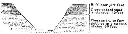
From the Columbia the railway crosses the broad, partly swampy alluvial flood plain of the river and enters a deep cut over a mile in length and 30 to 100 feet deep. (See fig. 4.) This cut goes through part of a terrace that projects into the angle between Columbia and Willamette rivers. East Portland is built on this terrace. The principal material exposed in the cut is fine sand, rudely stratified and containing scattered lenses and streaks of gravel, with a few pebbles as much as 6 inches in diameter. In this material at intervals of 3 or 4 feet there are thin beds of clay or clay and sand. Above this lies coarse cross-bedded gray sand and gravel capped by buff loam.
|
| FIGURE 4.—Section of deep cut of Northern Pacific Railway across Portland Peninsula between Vancouver, Wash., and Portland, Oreg. |
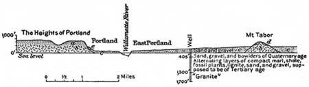
Beyond the cut the railway crosses the Willamette at Willbridge and turns to the left up that stream. East of the river, above a bluff, is Columbia University (Catholic). In the bluff, which is 175 feet high, are exposed lower beds than those seen in the cut, and they include, as may be seen at one point southeast of Mocks Bottom, larger bowlders and coarse gravel. On the right as Portland is approached is Guild Lake, the site of the Lewis and Clark Exposition in 1905. It is now being filled for factory sites by washing in gravel. Across the lake is a dark bluff, which is notched by the ravines of small streams that drain a plateau west of it. The bluff, which is made up of basalt lava, is capped by buff sandy loam that has resulted from the weathering of the basalt. A diagrammatic section from the plateau on the west, through the river terraces on which the cities of Portland and East Portland are built, to Mount Tabor on the east is shown in figure 5.
|
| FIGURE 5.—East-west section of Willamette Valley at Portland, Oreg., showing the relations of the sandy loam (a) and the basalt (b) of Portland Heights to the sand and gravel (c) on which Portland and East Portland are built and to the gravel (d) of Mount Tabor and the sandy loam (e) best exposed on the upper slopes of Westover Terrace. |
The flat-topped heights west of Portland, including Council Crest, are part of what in early Pleistocene time was an extensive nearly level surface produced by erosion—a peneplain, as it is termed by geologists. As such a surface is not produced until the region is worn down nearly to sea level, this plain must have been elevated since it was formed. Remnants of this old surface,1 which has been deeply cut by the present rivers and their tributaries, extend up the Columbia to Cape Horn and up the Willamette to a point beyond Oregon City.
1This peneplain is related to a similar one in central Washington and to an elevated beach along the coast of Oregon which records the ocean level at that time. It was in the later stages of this period of erosion that the basalt became so deeply weathered.
|
Portland, Oreg. Elevation 56 feet. Population 207,214. Seattle 186 miles. |
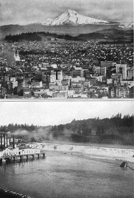
Portland, 186 miles south of Seattle and 771 miles north of San Francisco, is often referred to as the Rose City on account of the beauty and profusion of the queen of flowers in its gardens and even along its streets. An annual rose festival is held here during the first week of June. On the terraces and slopes in the western part of the city, which have a range of altitude of more than 1,000 feet, there are many beautiful homes, each with its garden, from which may be obtained views that are surpassed in few other cities in the world—such as the view across the Willamette to the snow-crowned peaks of Mounts St. Helens, Adams, and Hood (Pl. XI, A).
|
|
PLATE XI.—A. MOUNT HOOD FROM PORTLAND, OREG. Photograph
copyrighted by Weister Co., Portland. B. WILLAMETTE FALLS, OREGON CITY, OREG. |
The settlement was founded in 1845 by two men from New England and was named after Portland, Maine. It was chartered as a city in 1851. Its situation at the head of deep-water navigation on the Columbia and Willamette and at the gateway for railroads to the East through the gorge of the Columbia gives it great advantage as a commercial center. Steamships ply from it to many domestic and foreign ports. It exports every year raw materials and foodstuffs—chiefly wheat, wool, lumber, fish, and flour—to the value of over $15,000,000, and its manufactured products, including woolen goods, flour, and many other articles, amount to $35,000,000 annually.
The general uplift of the region that followed the formation of this peneplain caused the rivers to cut deep, wide valleys across it and expose the lava and underlying Tertiary sediments in bluffs such as those near Portland. Subsidence followed and the valleys were partly filled with gravel. A succeeding uplift enabled the rivers to carry away much of this old gravel in the Columbia Valley, but a remnant of it may be seen on Mount Tabor, a basalt knob in East Portland. The knob is itself a remnant of an extensive lava flow. Still another subsidence caused the rivers to deposit the gravels and sands of the terrace on which Portland and East Portland are built. These sands and gravels were themselves cut into and trenched in consequence of a later moderate uplift of the land. Finally, as has been seen, a relatively slight depression drowned the lower reaches of the Columbia and, of course, of the Willamette also. It thus appears that the land in this region has had many ups and downs in late geologic time. The movements here noted, however, are only the more conspicuous ones. Many minor oscillations have left less noticeable traces in the landscape. All these movements were probably so slow that they passed unnoticed by men if any were there at that time.
Among the more notable buildings are the Public Library, the Wells Fargo Co.'s building, the Chamber of Commerce, the Commercial Club, the Oregonian Building, and the Art Museum. Of the church buildings, the Presbyterian, Congregational, Baptist (White Temple), and Episcopal (Cathedral) should be mentioned. The City Hall contains the Oregon Historical Society's museum and the Hawkins Museum of Natural History.
Willamette River, which separates East Portland from Portland, is spanned by five bridges.
| Excursions from Portland. |
Electric cars afford easy access to the hilltop known as Council Crest, from which superb views may be had of the rolling lava plateau in which the Willamette has cut its valley, a country of rich farms and orchards. To the east may be seen the Cascade Range, surmounted by the lofty peaks of Mounts Rainier, St. Helens, Adams, Hood, and Jefferson.
Cloud Cap Inn may be reached in a day by the Oregon-Washington Railroad & Navigation Co.'s train up the south bank of the Columbia to Hood River station, thence by auto stage through the famous orchard country of the Hood River valley and up the northern slopes of Mount Hood to an altitude of nearly 6,000 feet. From this place the glaciers are in full view and may be easily reached. The cliffs along the south side of the Columbia (Pis. VII—IX), seen on this trip, are remarkable for their sheerness and for the numerous waterfalls that plunge over them to the river, but the cliffs upon the north side of the river are in general less imposing and lack falls. Fish wheels, log rafts for ocean transportation (Pl. X, B, p. 28), and the Cascade Locks are additional attractions of a trip that is well worth taking.
Astoria, near the mouth of the Columbia, may be reached by steamer or railway. The river is 5 miles wide here. At its mouth are the great Government jetty; Forts Stevens and Scarboro Head, which guard the entrance; lighthouses; and a life-saving station. Some typical sand dunes may be seen near Astoria, and the type locality for the rocks and fossils of the Astoria shale (Oligocene) is in this vicinity. Here, many years ago, Prof. J. D. Dana, then on the Wilkes expedition, observed some sandstone dikes, formed by sand that flied wide cracks in the rocks and later itself hardened into rock. As a rule dikes are composed of igneous rock which has been forced into such cracks in a molten condition. Dikes of sandstone are comparatively rare.
John Jacob Astor founded the town of Astoria in 1811 as a depot for the fur trade. It was seized by the British in 1813 but was restored in 1818. In 1821, while occupied by the Northwest Fur Co., it was burned and practically abandoned, the Hudson's Bay Co. being left in control of the country.
Trains from Portland by the Spokane, Portland & Seattle Railway connect with steamers of the Great Northern Pacific Steamship Co., which run to San Francisco three times a week.
| Willamette River. |
On leaving Portland for the south the railway crosses Willamette River and ascends its valley. The drainage basin of the Willamette is a roughly rectangular trough-shaped hollow, 145 miles long and 80 miles wide, lying between the Cascade and Coast ranges. Its area is over 11,000 square miles. The maximum power available from the river and its tributaries is 1,670,000 horsepower, of which 92,537 horsepower had been developed in 1909, the date of the United States Census report. The river is navigable for 100 miles, and shallow-draft steamers ply regularly from Portland to Oregon City, Dayton, and Corvallis.
East Morrison Street station is in the manufacturing suburb of East Portland, and a mile beyond, on the left, is the new Ford automobile factory. Half a mile beyond the suburb of Brooklyn, near milepost 767 from San Francisco, on the left, there are gravel terraces, on which stand the buildings of Reed College. For miles the railroad runs through a beautiful fertile country in which cultivated fields are interspersed with groves of firs, alders, and other trees. The white-flowered arrowwood, purple hardhack, and fireweed beautify the hedges and fields. Along this part of the route there are fine views of the even-crested bluff, probably of basalt, that bounds the valley of Kellogg Creek on the west. The smooth soil-covered slopes over which the train passes end abruptly against this bluff, which is probably due to a fault. Near Milwaukie (milepost 762), on the left, is Harmony School, and beyond are Mount Scott and other prominent rounded hills of lava (basalt).
|
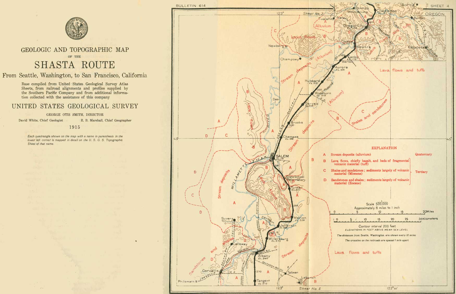
| SHEET No. 4 (click on image for an enlargement in a new window) |
|
Clackamas. Elevation 137 feet. Population 730. Seattle 197 miles. |
There appears on the left, just before the train reaches Clackamas (see sheet 4, p. 36) a small sulphurous-looking factory where spray compounds for fruit trees are made. The State Rifle Range is near Clackamas. Opposite the station there is a fine view of Mount Hood over field and forest.
Near milepost 758 the railroad crosses Clackamas River, which is bordered by banks of basalt. On the south side is Park Place station near Gladstone Park. As Oregon City is approached the valley of the Willamette narrows to a canyon between bluffs of basalt.
|
Oregon City. Elevation 102 feet. Population 4,287. Seattle 201 miles. |
Oregon City, situated at the Falls of the Willamette (Pl. XI, B, p. 29), is a manufacturing town and produces paper and woolen goods. The water here falls 40 feet over basalt to tidewater level. A large hydroelectric plant by the falls supplies light and power for Portland, and the maximum available energy is said to be 50,000 horsepower. A lock canal along the west bank of the river transfers steamers and other boats past the falls.
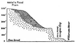
Basalt bluffs restrict the outlook from the train, but the accompanying section (fig. 6) shows what may be seen above the bluff on the left (east), near the quarry and crusher, and along the road to Ely.
|
| FIGURE 6.—Section of east bluff at Oregon City, Oreg. a, Stratified gravel and sand; b, stratified coarse sand; c, stratified fine loamy material; d, decomposed basalt resembling material of c. These materials are like those noted at Westover Terrace, Portland. They are well exposed near the quarry at the head of Munroe Street, Oregon City, and on the Molalla road to Ely. |
Dr. John McLoughlin, the Hudson's Bay Co. factor, settled here and did much for the early settlers and afterward for the town. His house is carefully preserved in a park that commands a fine view of the river.
Between Oregon City and New Era, a distance of 6 miles, the Willamette has cut a canyon 450 feet in depth across an extensive rolling upland on which are many fine farms. This upland is traversed by the Pacific Highway, a road from San Diego, Cal., to Vancouver, British Columbia. Along the sides of the canyon, at elevations of 100 to 200 feet above the sea, are remnants of a well-defined terrace. These are parts of a former bottom of the canyon, made when the river was flowing at a higher level. The upland is an old erosion surface, and was formed, together with the canyon and the terrace (fig. 6), while the gorge of the Columbia was being cut, before the falls at Oregon City came into existence. The falls have since cut back about a mile from their first position. In comparison with the recession of some falls—for example, Niagara, which has receded about 9 miles—this distance is not great, but the rock is hard and gives way slowly under the wearing action of the water.
Near Coalca, at milepost 751, on the left, scarcely visible among the trees of the terrace above the train, is Coalca or Balanced Rock, which marks the scene of many an Indian council.
|
New Era. Elevation 162 feet. Seattle 207 miles. |
At New Era the railroad emerges from the canyon into a broad alluvial valley deeply filled with unconsolidated material deposited by the Willamette and its tributaries.1 Gravel is dredged from the Willamette here and after washing and screening is delivered, wholly by machinery, in bunkers at the railroad ready for shipment. At Fishs Eddy the river impinges from the west against bluffs of lava; which cause it to turn abruptly northwestward. At this place may be seen some Pleistocene sediments, deposited in the valley probably while the river was temporarily dammed, as described in the footnote.
1The explanation of the fact that the Willamette between Oregon City and New Era flows through a canyon, while north of Oregon City and south of New Era it occupies broad valleys, is thought to be as follows: At a time not definitely determined but probably early in the Pleistocene epoch a fracture was formed in the basaltic rocks near the site of Oregon City. This fracture had a general northwesterly course. The rocks on opposite sides of it began to move, and apparently the principal movement was a rise of the rocks on the southwest side. The rocks were lifted as a tilted block, the hinge of the movement being somewhere near the site of New Era. The tendency of this movement was to dam the Willamette above New Era. Temporarily the river may have been ponded back, but on the whole it appears to have been able to cut a canyon in the basalt as fast as the rock rose. The Tualatin, a tributary which formerly entered the Willamette at Oswego, 5 miles below Oregon City, also had its course across the rising block of lava, but being a less powerful stream than the Willamette, it was unable to maintain its original channel. It was forced to flow southeast, along the sloping back of the uptilted block, and now enters the Willamette nearly 3 miles above Oregon City. Oswego Lake, a long, narrow body of water trending at right angles to the Willamette west of Oswego, is really a remnant of the former lower part of the Tualatin.
While the Willamette was engaged in cutting the canyon through the hard lava block it had time to swing from side to side above the obstruction and to erode from the softer rocks the wide valley which the traveler sees as he emerges from the canyon.
From this point to Salem the railroad passes through a region of broad alluvial plains with prosperous farms won from the great forest, which is represented now only by stumps and by scattered groups of tall firs.
|
Canby. Elevation 179 feet. Population 587. Seattle 210 miles. |
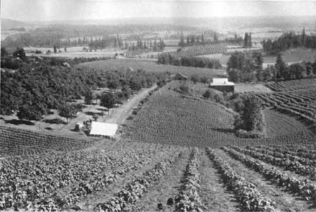
The Clackamas County Fairground is visible on the right as the train enters Canby. Half a mile beyond the town is a railroad gravel pit. The gravels have the characteristic delta structure, known as cross-bedding—a series of layers all inclined in one direction capped by nearly horizontal layers. They resemble the delta deposits seen near Puget Sound. Southeast of Canby, near Wilhoit, is a farm where teazels are grown. The dry thistle-like head of the teazel is used by fullers to comb up the nap on woolen cloth, and this farm is said to furnish a large part of the world's supply. At milepost 746 the railroad crosses Molalla River, which here flows along the east side of its broad, flat valley. In this valley are grown wheat, oats, potatoes, peaches, apples, and hops. In the neighborhood of Barlow and Aurora, where Pudding River is crossed, the forested areas increase, but to the northwest, near Newburg, there is a fine orchard country. (See Pl. XII.)
|
| PLATE XII.—WILLAMETTE VALLEY NEAR NEWBURG, NORTHWEST OF HUBBARD, OREG. |
|
Hubbard. Elevation 210 feet. Population 283. Seattle 218 miles. Woodburn. Elevation 210 feet. Population 1,616. Seattle 222 miles. Gervais. Elevation 212 feet. Population 276. Seattle 225 miles. Brooks. Elevation 230 feet. Population 1,018.* Seattle 230 miles. Chemawa. Elevation 188 feet. Population 2,043.* Seattle 233 miles. Salem. Elevation 191 feet. Population 14,094. Seattle 239 miles. |
At Hubbard and between Hubbard and Woodburn the country is open to the east, and the traveler may get views of the Cascade Range, with Mount Jefferson and other snow-covered summits. Woodburn is the center of a rich farming country. Beyond the station a vista opens on the right to the Coast Range. Rural scenes continue to Gervais, a town notable for its fresh, white cleanliness. About a mile beyond Gervais patches of blue toadflax (Linaria canadensis) may be seen in the fields in June. Less than a mile farther on, at the right, is a grove of oaks which contrast with the more common fir.
Just north of the town of Brooks is a noted loganberry farm, and during the season the adjacent oak woods are white with the tents of the berry pickers. The loganberry is a hybrid produced by crossing a red raspberry with a species of blackberry. It was named for its originator, Judge Logan, of California.
At Chemawa is an Indian school with good buildings and well-kept grounds. It has about 600 students and teaches in a practical way many trades and industries, giving most attention to agriculture. The results are well illustrated on the school farm. Prune, apple, and cherry orchards and berry gardens become more numerous as Salem, the State capital, is approached.
Salem is beautifully situated on Willamette River amid rolling hills that yield abundantly all kinds of farm, orchard, and garden products. It is in one of the most productive cherry districts of the State, and its cherry festival is an annual attraction. Salem is noted also as a hop and prune center. The State buildings are near the railroad on the right, and close to them are those of Willamette University. The State asylum for the insane and the penitentiary, surrounded by beautiful grounds, are about a mile from the railroad on the left.
A short distance west of Salem are some hills of basalt that are outliers of the great masses of volcanic rocks forming the Cascade Range. A pleasant trip on the Salem Heights electric car, running a mile to the south, will enable the traveler to see the lavas at many points and to obtain an excellent view of the city among its trees.
On leaving Salem for the south the railroad follows the valley of Mill Creek to Turner. The basalt hills just mentioned are on the right. Two miles from Salem, on the same side, is the Asylum for the Feeble Minded. On the left is the broad alluvial valley of Mill Creek, and a few miles farther along the State Industrial Training School for Boys, which stands on a hill that appears to be basaltic. Where the railroad rounds the basalt slopes on the right the bright-yellow monkey flower (Mimulus) borders the track in June, and at that season there is a wealth of flowers on every hand. The goldenrod (Solidago) appears even as early as the end of June, and among the small trees is the attractive madrona (Arbutus menziesii), with its brown bark and fresh, glossy evergreen leaves.
|
Turner. Elevation 332 feet. Population 191. Seattle 246 miles. |
For miles south of Turner the Cascade Range is in view on the left (east). Mount Jefferson and the Three Sisters can be seen if the weather is clear. On the right, a few miles away, are basalt hills, some densely forested with firs but others cultivated. The varicolored crops make a beautiful contrast with the forest.
Here, through spring and summer, the exultant song of the western meadowlark is heard, and bob white, the eastern quail who has been brought west, expresses contentment in his new quarters. Here, too, in the early hours of the day the traveler will hear the rippling music of the Chinese pheasant and will not wonder that Rostand's Chantecler, listening to that melody, forgot to give his clarion call that was to set the world going for another day.
|
Marion. Elevation 329 feet. Population 564.* Seattle 253 miles. Jefferson. Elevation 268 feet. Population 415.* Seattle 257 miles. Albany. Elevation 240 feet. Population 4,275. Seattle 266 miles. |
Marion is surrounded by a great hay country in which, as elsewhere in Oregon, vetch is grown with wheat and oats for hay, with excellent results.
At Jefferson the railroad crosses Santiam River, one of the largest tributaries of the Willamette. Under the bridge at low water can be seen dark, more or less carbonaceous shales. The railroad passes between hills of basalt and traverses the alluvial plain past Millersburg to Albany.
Albany, which is on a the Willamette at the mouth of Calapooya River, is an important railroad center. Branches from the main line of the Southern Pacific extend from it to the coast on the west and into the Cascade Range on the east.1 A short distance south of Albany the Cascade and Coast ranges are in full view. Both ranges have been so eroded as to present irregular sky lines. Marys Peak dominates this part of the Coast Range, and some basalt buttes between Santiam and McKenzie rivers are outliers of the Cascade Range.
1Trips over these branches give the traveler interested in geology and in the relations of mountains to valleys an opportunity to study a partial cross section of the Pacific System, including the Oregon Coast Range, the Willamette Valley, and part of the Cascade Range.
At Corvallis, on the way to the coast, is the Oregon Agricultural College, a State institution with which is connected a Federal agricultural experiment station. Here also are the headquarters of the Oregon Bureau of Mines and Geology. There were 28 graduate and 1,250 undergradu ate students at the college in 1913. Sandstones of Eocene age form the foothills west of the Willamette Valley and fossils belonging to that epoch occur near Corvallis. The crest of the Coast Range is composed of Astoria shale (Oligocene), but farther west, at Yaquina Bay, where the branch railroad ends, Miocene and Pleistocene fossils are abundant.
The Corvallis & Eastern Railroad, a branch of the Southern Pacific running east from Albany, follows up Santiam River, passes some sharp basalt buttes in the valley, and apparently crosses a belt of Eocene strata before reaching the lavas of the Cascade Range.
For 19 miles south of Albany the railroad runs through a highly productive grain and hay country. Oats and wheat are the principal grains produced and clover is grown, chiefly for seed. Vetch is sown with grain to some extent to make hay, but most of the hay crop is made from native grasses, which are cured and baled for market. From Albany Junction to a point a few miles south of Halsey, a distance of about 20 miles, the track runs due south as the crow flies. The station called Tangent is a few miles south of Albany Junction.
| <<< Previous | <<< Contents >>> | Next >>> |
bul/614/sec4.htm
Last Updated: 8-Jan-2007