
|
Geological Survey Bulletin 614
Guidebook of the Western United States: Part D. The Shasta Route and Coast Line |
ITINERARY
|
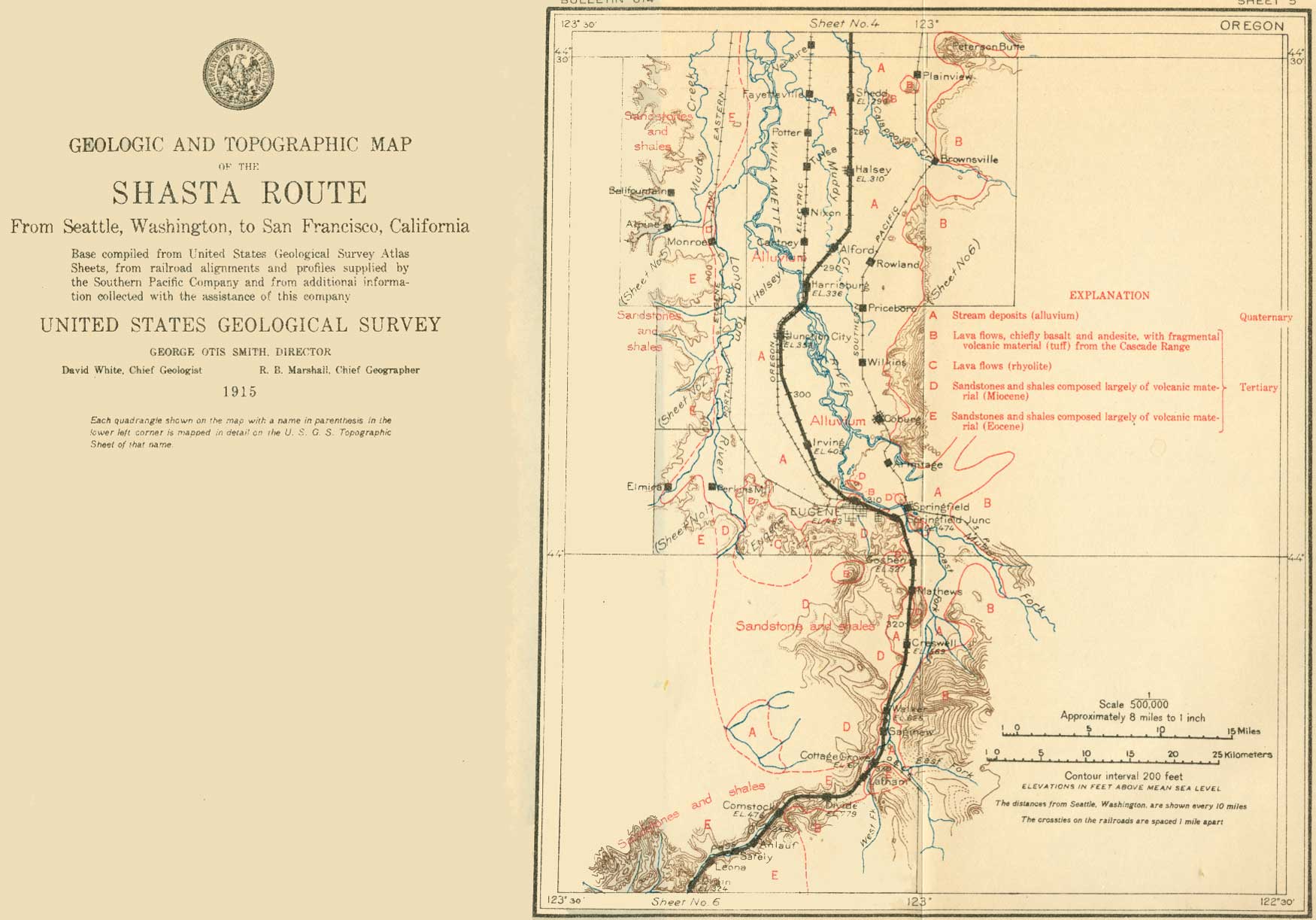
| SHEET No. 5 (click on image for an enlargement in a new window) |
|
Shedd. Elevation 290 feet. Seattle 278 miles. |
At the little town of Shedd (see sheet 5, p. 40) there is a creamery and also a flour mill. On the left (east), 2-3/4 miles away, is Saddle Butte, a volcanic cone from which basaltic rock is obtained for use in road making. A number of these cones, each marking a volcanic vent, probably of Eocene age, rise near the valley border. They are surrounded by alluvium washed into the valley, and a little cone between Shedd and Saddle Butte is nearly buried by these unconsolidated valley deposits.
|
Halsey. Elevation 310 feet. Population 337. Seattle 283 miles. Harrisburg. Elevation 336 feet. Population 453. Seattle 292 miles. Junction City. Elevation 353 feet. Population 759. Seattle 296 miles. Irving. Elevation 405 feet. Population 867.* Seattle 304 miles. Eugene. Elevation 453 feet. Population 9,009. Seattle 309 miles. |
About 6 miles beyond Halsey, in the vicinity of Alford, near milepost 667, good views can be had of the irregular crest of the Coast Range on the right and the foothills of the Cascade Range on the left.
Harrisburg is situated on Willamette River, in a country where shifting meandering streams, with many islands, make hard problems for the agriculturist. As a preliminary step to the work of reclamation by drainage, the Federal and State governments are cooperating in making large-scale topographic maps of this part of Willamette Valley.
Near Junction City fields of grain and hay abound and flowers adorn the roadside. Just beyond the station on the left (east) the little blue toadflax shines out. In June the bright blue, purple, or white chicory, the pink malva, and the yellow poppy give beauty to the scene.
In the vicinity of Irving groves of English walnuts and orchards of apples, prunes, and peaches, with large patches of loganberries and other small fruits, alternate with fields of wheat, oats, corn, and grass. Beyond Irving the hills begin to close in on the valley from both sides.
As the train enters Eugene, an attractive city at the head of the wide part of Willamette Valley, Skinner Butte, which rises 260 feet above the track and has a quarry on its north slope, is seen near by on the left. The well-marked columnar structure of its basalt is clearly visible and illustrates the character of many of the buttes farther north in the Willamette Valley. All these buttes are composed of solid basaltic lava and appear to be the remnants of ancient volcanoes that have been subjected to long erosion and worn down to their solid cores or hard central parts, called plugs because they fill the opening through which the lava had been ejected.
At the University of Oregon, in Eugene, is the large collection of fossils made by Prof. Thomas Condon, who in his day did much to interpret the geology of Oregon.
A stage line up McKenzie River, the largest tributary of the Willamette, which enters the valley near Eugene, leads to the Blue River mining district and gives access to the hunting and fishing grounds about the Three Sisters, snow-clad peaks that carry the a largest glaciers in Oregon. The extent of these glaciers during the glacial epoch has not been determined. An ice stream of considerable size probably once occupied the basin at the head of the McKenzie, but no evidence of glaciation has been recognized in the lower McKenzie Valley. Stray bowlders found at a number of places in the Willamette Valley have been more or less doubtfully attributed to ice floating in a body of water which Prof. Condon named Willamette Sound.
Railroad cuts on a branch now being built from the main line at Eugene across the Coast Range to Coos Bay will no doubt display good sections of the Eocene sediments of which this part of the range is largely composed. Another branch runs southeastward from Eugene up the valley of the Middle Fork of the Willamette to Oak Ridge. This branch when extended across the Cascade Range and connected with a line already built from Weed, Cal., to Kirk, Oreg., by way of Klamath Falls will form the main line of the Southern Pacific from Eugene to Weed. This route will avoid the deep cross-drainage valleys of Umpqua, Rogue, and Klamath rivers, will make Crater Lake National Park more easily accessible, and will be superior in scenic and geologic interest to the route now followed.
The rock underlying Eugene is a fossiliferous gray sandstone of Tertiary age.
|
Springfield Junction. Elevation 474 feet. Seattle 312 miles. |
The University of Oregon is passed on the right (southwest) a mile from the station at Eugene. A mile farther on may be seen an abandoned quarry of the fossiliferous sandstone, also on the right. Beyond it the railroad passes through an area of basalt hills, succeeded by shales. At Springfield Junction the shales give place to a gray sandstone full of marine shells like those seen nearer Eugene. This fossiliferous sandstone may be seen in an old quarry on the right side of the railroad. Half a mile beyond Springfield Junction are bluffs of fragmental volcanic material (tuffaceous conglomerate), which continue for nearly a mile. This material is cut by dikes of basalt, which may be seen along the banks of the river. After passing these the railroad takes final leave of Willamette River and in a climb of 20 miles surmounts the low divide between the Willamette and the Umpqua. For nearly 200 miles now the route is in the area of generally hilly country which, as noted in the preliminary sketch of the region, separates the Willamette Valley from the Great Valley of California and links the Oregon Coast Range and Klamath Mountains with the Cascade Range and the Sierra Nevada. From Eugene nearly to Greens, a distance of 80 miles, the route traverses Eocene sedimentary or eruptive rocks except where these are covered by alluvium.
|
Goshen. Elevation 527 feet. Population 414.* Seattle 312 miles. Creswell. Elevation 569 feet. Population 367. Seattle 321 miles. Cottage Grove. Elevation 671 feet. Population 1,834. Seattle 330 miles. |
At Goshen basalt forms the hill directly opposite the station and extends at least to Spencer Butte, a prominent peak of the same material, which soon comes into view on the right (west). Between Mathews and Creswell is a wide stretch of alluvial plain on which are young orchards of a great variety of fruit trees. From Goshen southward the valley narrows to Walker, being bounded on the left (east) by the end of a bold spur of lava from the Cascade Range. The low hills on the right consist mainly of sandstones and shales, of Miocene age, but at one point a mile east of Saginaw basalt occurs on the right and is crushed for road material.
A branch line from Cottage Grove runs up Row River into the Cascade Range, toward the Bohemia mining district, which has produced gold for many years. Gold was discovered here in 1858, and the total production has been between $300,000 and $400,000. The gold-bearing quartz veins of this district traverse Tertiary lavas. Quicksilver ore occurs at several places in this region, and an attempt has been made to mine it at Black Butte, on the Coast Fork of the Willamette 17 miles south of Cottage Grove.
|
Latham. Seattle 331 miles. |
The Southern Pacific Co. has a plant at Latham for treating wooden railroad ties with chloride of zinc to increase their durability. This treatment is called burnettizing, from Sir William Burnett, who patented the process. Without treatment the ties last about six years, but when burnettized they last eight years. Dated nails are put in all the ties, of which more than 3,000 are treated daily.
|
Divide. Elevation 779 feet. Seattle 335 miles. |
Leaving the Coast Fork, the railroad ascends a branch valley to the low pass across Calapooya Mountain that separates the drainage basin of the Willamette from that of the Umpqua. Calapooya Mountain is the most northerly of the transverse ridges from the Cascades to the Coast Range and is composed of Eocene sediments and intrusive igneous rocks succeeded on the east by later Tertiary lavas. The terraced slopes of this pass suggest that formerly Umpqua River flowed through it and joined the Willamette. In the course of time, however, its waters found a shorter way through the Coast Range to the sea.1 Igneous rocks appear near by on the right in the divide and on the left in Wards Butte.
1A cross section of the valley cut through the Coast Range by the Umpqua shows certain features that throw light on the later geologic history of the region. In the first place, if the section given in figure 7 were extended it would show that the summits of the hills north and south of the river are more or less flat and at nearly the same level. An observer standing on one of these hills and looking over the country could disregard the present valleys and imagine that his vision was sweeping over a vast rolling surface that was nearly level—a peneplain. The imagination would merely be recalling what was once reality—a land surface worn down nearly to sea level through long erosion by rain and streams. The Umpqua flowed across this surface to the sea.
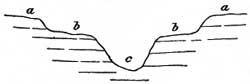
FIGURE 7.—Generalized section of Umpqua River valley in coast Range, Oreg. a, Peneplain; b, earlier valley; c, later valley. The next event was a slow rise of the land, in consequence of which the river began to flow faster and to deepen its valley. After it had cut down to a considerable depth the upward movement of the land apparently ceased for a time and the river stopped cutting and began to meander and thus to widen its valley. Later the upward movement of the land was renewed and the river again began to cut down its bed, leaving remnants of its old valley floor as benches or terraces along the sides of its present valley.
A similar relation of peneplain, terrace, and present valley bottom can be deciphered along nearly all the larger streams of the Klamath Mountains and adjacent parts of the Coast Range. This shows that a large area was affected by the same vertical movements of the land.
The Umpqua flows through the Coast Range to the sea in a direct course, which presents a strong contrast with its meandering course east of the range. This difference is due to the fact that in the relatively hard rocks of the Coast Range the stream has been busily cutting down and has not remained long enough at any one level to widen its valley greatly. In the area east of the Coast Range the river has probably flowed over softer rocks and at some stages in its history has had time, between periods of active downward cutting, to swing from side to side, widen its valley, and establish graceful meanders after the common habit of low-grade streams.
The railroad now enters the Umpqua basin and continues in it for over 100 miles. In the descent down Pass Creek may be seen outcrops of tuffaceous conglomerate (formed of volcanic fragments), which is quarried here and there for riprapping the roadbed. As the general dip of these rocks is northeastward, successively older strata appear in the course of the southwestward descent. Near milepost 619, on the right, is an old quarry in sandstone which contains numerous fossil leaves of Miocene or Eocene age.
|
Comstock. Elevation 476 feet. Population 321.* Seattle 339 miles. |
At Comstock there are traces of coal in the sandstones, and a few Eocene shells have been found. The valley of Pass Creek in general is narrow and lies between wooded hills of fine fir timber. Here and there, however, it widens, and fields of hay and grain extend for some distance up the hillsides. Lumbering is still the principal industry of the region. Anlauf, Safely, and Leona are passed between Comstock and Drain.
|
Drain. Elevation 324 feet. Population 335. Seattle 348 miles. |
At Drain the railroad crosses Elk Creek and enters a gorge cut in hard basaltic rock, illustrating the fact, already pointed out, that where the rock is hard erosion is slow and the stream valleys are narrow, but where the rocks are soft, as north of Drain and near Yoncalla, erosion is more rapid and the streams readily widen their valleys. A stage line from Drain down Elk Creek and the Umpqua reaches tidewater at Scottsburg, about 25 miles from the coast. Near milepost 606, on the right (west), is a mineral spring (Bozwell Spring).
| <<< Previous | <<< Contents >>> | Next >>> |
bul/614/sec5.htm
Last Updated: 8-Jan-2007