
|
Geological Survey Bulletin 707
Guidebook of the Western United States: Part E. The Denver & Rio Grande Western Route |
NARROW-GAGE LINE FROM SALIDA TO MONTROSE.
The description of the country along the main line east of Salida ends on page 90.
The part of the Denver & Rio Grande Western Railroad that runs over Marshall Pass was a part of the main line built with a 3-foot gage in 1881, and because of its steep climb over the mountains and its tortuous course through the Black Canyon of the Gunnison it has not been changed from its original gage. To the traveler who has never ridden in a narrow-gage coach the name "baby railroad," which was given to this system in the early days, seems eminently proper; but after traveling over the mountains and turning and twisting through the narrow canyons he gains respect for the narrow-gage road, which in this part of the country was the pioneer of railroads and led to the development of the mineral resources and the agricultural wealth much earlier than if the road had been built standard gage. In Colorado, however, the day of the narrow-gage road seems to have nearly passed, and all such lines will probably be abandoned or changed to standard gage.
|
|
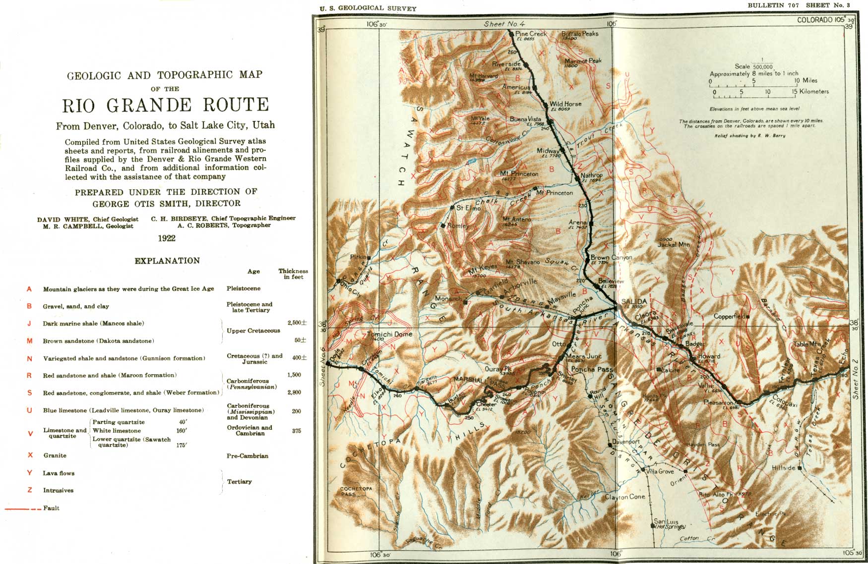
SHEET No. 3 (click on image for an enlargement in a new window) |
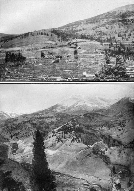
The country about Salida is well watered, and much hay and grain is grown for the herds of cattle that may be seen from the train. Some fruit is raised, but the altitude here is so great that only the more hardy varieties will ripen. On leaving the station the railroad runs southwestward, directly toward the great mountain wall that bounds the valley. (See sheet 3, p. 100.) It ascends the valley of South Arkansas River, in which no rock can be seen in place except at a distance until the train enters the mountains. The immediate valley is excavated in gravel and boulders, which may be seen on the right in the cut edge of a well-developed terrace.48 The top of this terrace, when seen from a high point, appears to be a part of what was once the floor of the valley. Remnants of a similar though higher terrace may be seen in the foothills on the left at a much greater elevation. (See Pl. XLIV, p. 90.)
48The mode of formation and hence the meaning of terraces is of great interest to the geologist who is attempting to unravel the history of the land. Terraces are mainly the work of water, either running, as in streams, or standing, as in a lake or ocean; but the present surface of Colorado has not been modified by the ocean and very little by lakes, so that most of the terraces here were formed by running water:
Streams may form terraces of two kinds, known as cut terraces and built terraces. A stream may flow against a bluff of solid rock and cut it away above a certain line and thus produce a flat which, when the stream has further excavated its valley, may be revealed as a terrace or bench. Such a terrace is represented in figure 40. A stream, a, has cut a valley in solid rock, represented by the diagonal-ruled lines. After the stream has formed a flood plain it begins to meander or swing from side to side across the flood plain. In the course of such a swing it may flow against the slope on the right and then, if the stream is accelerated by uplift, it will clean out its old valley and cut a trench (c) in its rock floor, leaving the part at b untouched. The part at b is then a rock terrace on the side of the valley and merely a remnant of the old valley formed when the stream was flowing at a higher level. Such terraces are called cut terraces and are rather rare.
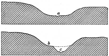
FIGURE 40.—Formation of a rock terrace. The second kind of terrace is known as a built terrace because it is built of waste rock material by waves or running water. Most if not all of the terraces in a mountain region are built. A terrace is generally not built up directly by a stream but is the result of the filling or partial filling of the valley and of its partial excavation by the stream. If a mountain stream, such as the Arkansas, which is now able to carry along nearly all the sand and boulders swept into it by its tributaries, should be dammed by a flow of lava or other obstruction, it would be unable to carry its load of this material, which would be dropped in the pond above the obstruction. In time the material would fill this pond and form a plain that would stretch entirely across the valley. The result is shown by section A, in figure 41, in which the valley is represented as filled with gravel and sand, forming a plain a-b, over which the stream flows at c, far above bedrock. If the stream then succeeds in cutting through the dam of lava it quickly trenches the sand and gravel laid down in the pond, except the parts that lie at some distance back from the middle of the channel. The result is shown by section B, in figure 41, in which the stream has cut the trench d-f-e, leaving d and e as terraces on the sides of the valley, composed of sand and gravel which the water has deposited. Most of the terraces in the mountains have had such an origin, except that the ponding has generally been due not to lava flows but to the sinking of the crust of the earth, which would have the same effect as a lava flow. In some places it may have been due to a decrease in the volume of water flowing in the stream, and although at first thought this may not seem to be comparable to the lava flow in its effects, a careful study will show that the carrying power of a stream is directly affected by its volume and grade, so that if its volume or its grade is reduced its carrying power will be reduced—it will not be able to sweep along the boulders that it had before handled readily. A stream thus reduced in volume or grade silts up its bed, and if later its flow or grade is increased it cuts away all this material except the remnants that form terraces.
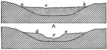
FIGURE 41.—Formation of a gravel terrace.
The traveler is now near the high mountains, and he may look up on the left to lofty peaks on which the snow banks of the preceding winter linger well into the summer and on which a fleecy mantle falls during the first snowstorms of early autumn, or even occasionally during a cold midsummer storm. The commanding summits which may be seen from time to time are Ouray Peak (altitude, 13,955 feet), near Marshall Pass (altitude, 10,856 feet), and Mount Chipeta on the left, and a group of peaks known as Mount Shavano (altitude, 14,179 feet) on the right. The lower slopes are more or less covered with timber, which becomes scanty as the height increases, until finally even the stunted balsams disappear (see Pl. XLV, A, p. 92) and at the summits there is nothing but wind-swept rock. The slopes vary in color according to the light, at times being rich red or bright yellow in the strong sunlight and at others deep purple or a steely blue. The color of the lower slopes depends largely on the vegetation, but that of the upper slopes depends on distance and light. In spring and summer the shrubs and trees present many shades of green and yellow, but they are most brilliant in September, when the first frost touches them and tinges them with red or gold.
|
Poncha. Elevation 7,480 feet. Population (including Poncha springs) 323. Denver 220 miles. |
The railroad follows the valley up to the village of Poncha, where the road to Marshall Pass turns to the south (left), but a branch keeps straight ahead to the mining town of Monarch, 15 miles distant, where it ends. From Monarch the principal highway between Salida and the Gunnison Valley is an automobile road across the range. The Marshall Pass line turns to the south in a broad curve and begins to climb the range. For half a mile it cuts through ridges and spurs of gravel and boulders which constitute a part of the high terrace already mentioned. Near milepost 222 it enters the canyon which Poncha Creek has cut in the hard rocks that compose the mountains.
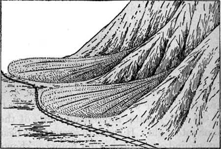
A quarter of a mile above milepost 223 the railroad swings to the left in a broad curve around a mass of loose material which has been swept down from a small gulch on the right, and almost immediately after swinging back into its normal position it has to make another curve in order to pass a second mass of similar loose material. Such masses, if fairly flat, are known as alluvial fans, but if steep they are called alluvial cones. The fans in Poncha Canyon are shown in the accompanying diagram (fig. 42). On the first fan the radial lines occupied by the streams at different times can easily be seen from the train, as they are marked by straight depressions and by ridges of boulders and angular pieces of broken rock which have been swept down by the stream.
|
| FIGURE 42.—Alluvial fans in Poncha Canyon. The material that has been swept out of two ravines in the mountains is spread out in semicircular fans, which the railroad is obliged to pass around in two sharp curves. |
|
Mears Junction. Elevation 8,431 feet. Denver 226 miles. |
The canyon is narrow and V-shaped as far as Mears Junction, where it abruptly changes to a rather broad valley with a flat, swampy bottom, which bears all the marks of having been occupied by moving ice—that is, by a glacier.49 At Mears Junction a branch railroad turns to the right and after circling about over the main line turns back on the left and climbs the mountain slope to Poncha Pass, which stands at an altitude of 9,059 feet, and then descends into San Luis Park. Curiously enough, this branch line, in the heart of the Colorado mountains, has one of the longest stretches of straight track in this country—52 miles without a curve. Poncha Pass is much lower than Marshall Pass, and the traveler may look down into it when he is part way up the mountain.
49A glacier that occupies a rather broad, flat-bottomed valley almost in variably builds a ridge at its lower end, composed of fragments of rock mixed with clay that it ground away from the rocks over which it passed. All this material is carried on or in the moving mass of ice and is laid down at its extremity in a ridge that is known as a terminal moraine.
If Poncha Valley had once been occupied by ice it should contain some trace of a terminal moraine, although a moraine in a narrow valley may be more or less washed away by the stream after the ice has disappeared. A close examination of the side of the valley below Mears Junction shows such an accumulation, though it may not be noticed from the moving train. It consists of a distinct ridge of loose material which projects from the east (left) wall of the valley and causes the stream and the railroad to curve to the right in order to pass it. At the point where the railroad rounds the outermost point of the moraine there is a sign marked "Yard limit." Here, then, is a fragment of a terminal moraine, which indicates that the valley above has been broadened and its walls steepened since it was carved by running water, so we must conclude that a great glacier long ago gathered on some of the high peaks that border the headwaters of Poncha Creek and flowed down to this point.
Above Mears Junction the character of the valley is different in different parts, making the answer to the question whether it was occupied by ice somewhat doubtful.50
50About a mile above Mears Junction the valley changes from a broad, flat-bottomed swale to a narrow rocky ravine down which a glacier could probably not have moved without scouring it and changing its form. Where, then, did the glacier come from that scoured the valley at Mears Junction and built the terminal moraine a short distance below? It is not apparent from the train where this body of ice could have originated, but if the traveler could climb some of the low hills on the right he would find that they are composed of gravel and sand, and that instead of being the foothills of the mountain they are only low hills that separate Poncha Creek from the wider valley of a tributary on the west, which drains the valley between Ouray and Chipeta peaks and joins Poncha Creek through a narrow gap in the hills just above Mears Junction. It thus seems that the glacier came down this broad valley before the hills on the west side of Poncha Creek were built and that it extended down the main valley to the terminal moraine already described and then retreated. After a long interval it readvanced, though not so far as formerly, and built on the west side of Poncha Creek a terminal moraine which now could be easily mistaken for the normal walls of the valley. Another glacier must have come down Poncha Creek, for the valley broadens a short distance farther up and has all the appearance of having been occupied by ice. This glacier came down the valley of the east fork, which has been scoured out until its cross section is a symmetrical U. This glacier originated near Poncha Pass and extended only a few hundred feet into the main valley.
About 2 miles above Mears Junction the valley is again wide and flat-bottomed and has all the features generally attributed to occupation by ice. In this wide part of the valley the railroad crosses to the east side, where it runs for nearly a mile, and then swings across the creek and returns on the opposite slope. As the road curves across the creek the traveler may see by looking upstream that this branch of the valley is not broad or U-shaped and was therefore probably never occupied by ice. As the train climbs the west wall of the valley many interesting views of the features described above come into sight. It turns in around the head of every ravine and then out around every projecting point, as shown in Plate LXIX, B, until finally it comes to the top of the hills that face the valley. On one of the last bends the traveler may look down upon Poncha Pass, but, from a distance so great that good eyesight is needed to distinguish even the telegraph poles that mark the line of the railroad. The chain of high peaks which lies behind the pass and which is known as the Sangre de Cristo Range here begins to loom up, and as the journey continues it grows steadily in apparent magnitude until it is lost to view over the summit of Marshall Pass.
|
|
PLATE LXIX. A (top). MARSHALL PASS.
View from the hills on the south. This pass was discovered in 1873 by
Lieut. William L. Marshall. Its striking feature is the lack of the
ruggedness that characterizes many of the other passes through the Rocky
Mountains. Photograph by Whitman Cross. B (bottom). OURAY PEAK. This view shows the tortuous route followed by the railroad in its climb to Marshall Pass, which lies to the left, behind the shoulder of the mountain. The great glacial cirque in the northeast side of the mountain looks like a crater, and on that account the mountain has been called a volcano. Photograph by the Detroit Publishing Co.; furnished by the Denver & Rio Grande Western Railroad. |
As the train continues to climb upward the traveler will observe that the slopes become less and less rugged, and he soon begins to realize that the mountain masses about him, which looked so formidable when seen from below, are really only the foothills of the higher range and that many of these foothills have a nearly common height and are relatively flat topped. These flat tops stand at an altitude of 9,300 to 9,500 feet and may correspond with the rolling plain at the north foot of Pikes Peak and with the tops of the Front Range as seen from Denver. Their equivalence with those features can not be regarded as proved, but they suggest that at one time much of the mountain region of Colorado was a rolling plain above whose generally even surface only a few high knobs projected. Later this surface was upraised to its present position, and the mountains as we know them to-day were carved from the uplifted mass.
As soon as the railroad reaches the top of the hills that front the valley it changes its course to one directly toward Mount Ouray, which is the most conspicuous feature in the landscape. The road winds considerably, but from time to time the peak can be seen from either side of the train, though the best views are from the left. The peak is not symmetrical, but looks as if some giant had taken a great bite out of the side next to the traveler, as shown in Plate LXIX, B. And, indeed, a giant has taken a bite out of the side of the mountain, but the giant was a glacier that once lay high up on its slopes and that gradually ate out a great amphitheater or cirque, as it is called by geologists.51 This cirque looks large even from the train, for it is about half a mile wide and probably 1,000 feet deep, but what must it look like when viewed from its rim!
51The exact method by which a glacier excavates an amphitheater or cirque is not very well understood, as all the work is done under the ice and hence can not be seen. It can be judged only by the form of the cirque after the glacier has melted away.
The term glacier means moving ice. The snow falling on a mountain side consolidates into ice under its own weight and finally becomes so heavy that it begins to move down the slope. In doing so it takes with it some of the underlying rock to which it has frozen, and this action, repeated many times, tends to produce a hole in the mountain side. As the tendency is to pluck out the rock equally in all directions from which the ice moves to the point of outlet the cirque has a semicircular shape and the plucking tends to cut back horizontally, so that the floor of the cirque is nearly level or it may be slightly deepened so as to form a rock basin. The walls of cirques in many kinds of rocks stand nearly vertical, but the walls of the cirque in Ouray Peak, which are composed of granite, take on a more gentle slope, as shown in Plate LXIX, B.
Ouray Peak is supposed by some to be an extinct volcano, probably because of the resemblance of this cirque to the crater of a volcano. One of the best places from which to see this cirque is Grays siding, at an elevation of about 9,673 feet. Here the locomotive may take water, and the traveler may have an opportunity to step from the train and obtain a view of the mountain and the surrounding features.
A short distance above Grays siding extensive views appear on the left at many places. The chief points of interest are the peaks of the great Sangre de Cristo Range, and at their base the upper end of San Luis Park. Farther up the railroad the slopes on the left are very steep and are covered with a mantle of trees. The trees are not very large or very thick, but they conceal and soften rocky slopes that would otherwise be bare. Here the traveler may see the blue spruce for which Colorado is noted. Only the young growth has the characteristic bluish-green color, but when the cones have reached their full growth the tree is one of the most beautiful in the forest. In midsummer these slopes form a sea of green; but if the traveler should cross the pass after the middle of September he will see the aspens in a golden blaze, and even in the thick forest he may see specks of yellow as brilliant as any of the "colors" in the prospector's pan in the early days when he struck "pay dirt."
Beyond milepost 239 the railroad runs along the side of a bouldery ridge at the foot of the bare cone of Ouray Peak. The traveler is at first so far below the summit of this ridge that he probably does not realize that it is a moraine which was evidently formed by one of the last glaciers that existed on the south slope of the mountain, but when he is a little nearer the summit of the mountain he will be able to see the small cirque which this glacier excavated, though he will notice that it is not nearly so large as the cirque which he saw from Grays siding. The reasons for the difference are that the glacier which lay on the east side was in the lee of the mountain and received more snow than the other one, which was exposed to the strong west wind, and that the snow which fell upon the glacier that faced the east was not readily melted, whereas the other glacier, which faced the south, must have received the full warmth of the sun's rays. As the glacier on the east side was thus favored in the accumulation of snow and in the slight melting of the ice it grew apace, whereas the one on the south side was always small and doubtless soon dwindled away.
|
Marshall Pass. Elevation 10,856 feet. Denver 240 miles. |
Beyond the moraine the railroad passes through a swampy flat, which is possibly the cirque of a much older glacier than those just described. The traveler will see on the right the station of a ranger who guards the national forest. Although his station is desolate and the passing trains are his only diversion this ranger must remain here on duty to prevent forest fires and to look after the interests of the Forest Service. At last the train stops in a small cut, and the traveler is at the summit of Marshall Pass, more than 2 miles above the level of the sea. This pass as it appears from the hills on the south is represented in Plate LXIX, A. The view from the summit, like that from many high mountains, is not so striking as a view from a point lower down, but it includes a vast expanse of country, especially on the west. Few real mountains can be seen in that direction, and the high land in sight consists mostly of vast plateaus which lie at different elevations. The pass was named in honor of Lieut. William L. Marshall, who was the first white man to cross it, in 1873.51a
51aMarshall Pass was discovered in 1873 by Lieut. William L. Marshall, later chief of engineers in the United States Army, not as the result of systematic exploration, but in order to find relief from toothache. The following account of the discovery is condensed from a recent article on the subject by Thomas F. Dawson in "The Trail" (Sept., 1920), the official organ of the Society of Sons of Colorado.
In 1873 Lieut. Marshall, in charge of the Colorado branch of the Wheeler Survey, had spent the summer and autumn in the San Juan region, but on the approach of winter the snow became too deep for mountain exploration and he decided to abandon work and go to Denver. It was arranged that the party should follow the regular route by way of Cochetopa Pass, but as Lieut. Marshall had a very painful toothache, he decided to strike out on some shorter route so as to reach Denver ahead of his party and to find relief from his suffering. He accordingly started with one companion, Dave Mears, on mule back and with one pack animal to find a short cut. He first tried to cross the range west of Twin Lakes but found the snow too deep; then he tried an entirely new route at the head of Gunnison River, and after a hard struggle through fallen timber and deep snow he reached the summit in a pass which he had seen from a distance but never crossed. Lieut. Marshall realized that the pass he had discovered was one over which a road or even a railroad could easily be constructed, so despite the toothache and the icy wind the party spent a day and night on the summit making observations of the temperature and barometer and preparing a profile showing the approaches on both sides.
When the observations were completed the party pushed on to Denver, where a dentist soon relieved the toothache. In a short time the news of the discovery of the pass became noised about and Lieut. Marshall was waited upon by a delegation of prominent citizens who, with true western push, organized the Marshall Pass Toll Road Co. and in a few months completed a wagon road through the pass.
What would the traveler of to-day think of making a mule-back journey of 300 miles in the snow across the mountains of Colorado to find relief from a toothache! Such a trip would be bad enough to make under present conditions, but what must it have been through an unbroken wilderness and across the backbone of the continent! Truly the "winning of the West" called for courage and endurance of which the traveler of to-day, with all the comforts and even luxuries of travel, can have little comprehension.
The railroad cut at the summit of the pass is in a volcanic breccia made up of bombs and other fragments thrown out by a volcano and afterward consolidated and cemented into a bed of rock. The source of this volcanic material is not known, but it probably came from the south, where the eruptions were many and violent, though they did not extend into this region. This breccia is much younger than the rocks of Ouray Peak, and it therefore does not indicate that that mountain is a volcano.
The steepest railroad grade on the east side of the summit is 4 per cent, or 211 feet to the mile, a grade that is maintained from a point not far above Mears Junction to the summit, a distance of 14 miles. The grade on the west side is the same from the summit of the pass to a point about a mile below Chester, a distance of 9 miles. As the maximum grade on the standard-gage main line is only 3 per cent, or 158 feet to the mile, a change in gage here would probably mean an entirely new location, so as to avoid the steep grades and short curves.
On emerging from the snowsheds at the summit the traveler has spread before him on the left the long slope down which the railroad winds with many loops and turns. This side of the mountain is more nearly treeless than the east side, because it is much drier, for it is swept by dry winds that have passed over the arid plateaus of southern Utah and Arizona. There are no indications that glaciers ever existed on this side, for the entire slope is exposed to view and nothing resembling a terminal moraine can be seen. This fact also is due to the strong west winds and the drier atmosphere on the west side and to the greater heat of the sun's rays, which aided the melting of the snow on the south and west sides. After the train loops back directly under the pass there is little of interest to be seen; the slopes are generally smooth, and the valley is without scenic attractions.
A short distance west of Marshall Pass the railroad goes from volcanic breccia to granite and then onto quartzite and shale. similar to those seen below the Ouray or Leadville limestone in both Eagle River canyon and the canyon of Colorado River above Glenwood Springs. These rocks are not strikingly exposed and probably will be detected only by those who look specially for them.
|
Chester. Elevation 9,412 feet. Denver 249 miles. |
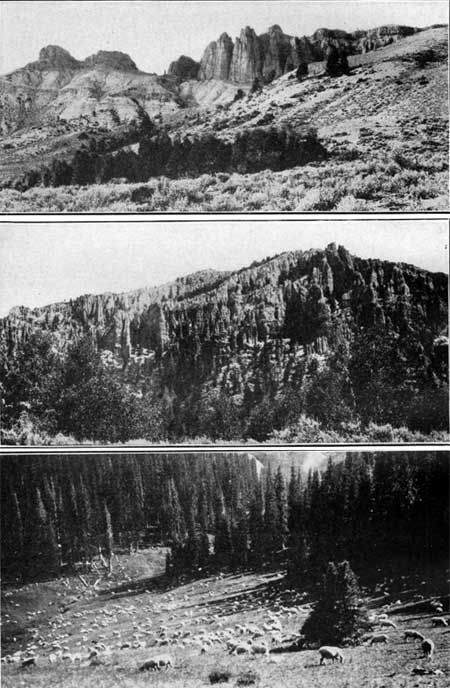
The railroad gradually descends the slope, and at Chester it is at the level of Tomichi Creek. For some distance the valley is small and narrow, but farther on it opens, and crops of hay may be seen on the flood plain. The chief industry of the country is stock raising, for the high mountains afford excellent summer pasture and the bottoms along the creeks produce hay for the subsistence of the stock during the winter. Cattle may be seen on the range at many places, especially in midsummer, and bands of sheep find pasture at the foot of the highest mountains. (See Pl. LXX, C.)
|
|
PLATE LXX. A (top). SPIRES OF VOLCANIC ROCK NEAR SAPINERO.
Much of this country was once covered with volcanic luff consisting of
fragments of lava of all sizes, which is bedded like shale or clay. It
is soft and is readily cut by rain and streams into beautiful and
fantastic forms. Photograph by Willis T. Lee. B (middle). INTRICATE EROSION OF VOLCANIC ROCK. This mass of volcanic tuff is so dissected by rain erosion that it consists only of numberless spires and pinnacles. It makes picturesque cliffs that are hard to climb. Similar sheets of tuff cover the hills on both sides of Gunnison Valley. Photograph by Willis T. Lee. C (bottom). SHEEP IN THE GUNNISON COUNTRY. Many sheep are pastured in the Gunnison country. In midsummer they reach the higher slopes of the mountains, as shown in this view. Photograph by J. F. Hunter. |
|
Sargent. Elevation 8.477 feet. Population 288. Denver 257 miles. |
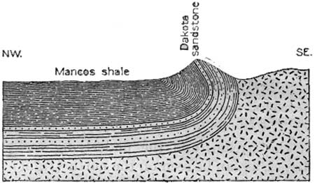
Below Chester the valley expands, and at Sargent the stream, which the railroad has been following, is joined by a large branch from the north. Sargent is a busy railroad point which still bears the marks of a frontier settlement. Here "helper" engines are kept to assist the trains up the heavy grade to the summit. The rock near Sargent is mainly granite, but it is not conspicuous, for most of the slopes are smooth and round and few ledges are visible. The granite extends as far as milepost 263, where it is replaced by sandstone (Dakota), which forms a pronounced hogback on both sides of the tracks. This hogback forms one edge of a broad, flat basin of sedimentary rocks that extends practically to Gunnison. Where first seen the Dakota sandstone is overturned, as shown in figure 43, showing that the downfolding of the basin was accompanied by a strong thrust from the east.
|
| FIGURE 43.—Overturned eastern rim of the syncline at Crookton. Dakota sandstone dips steeply to the southeast. |
|
Doyle. Elevation 8,062 feet. Population 122.* Denver 270 miles. |
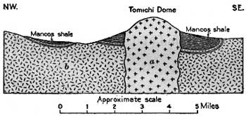
The Mancos shale forms the surface of the inner part of this great basin for a long distance. This shale is so soft that it is seldom seen in outcrop, but it has a decided effect in subduing the features of the landscape. The valley has a width of 2 or 3 miles, the slopes bordering it are gentle, and the hills are low. In the midst of the broad valley, or rather on its north (right) border, is a prominent mountain called Tomichi Dome, which rises more than 2,000 feet above the level of the valley. As shown in figure 44 this mountain is a great stock or mass of granite; much younger than the granite of the main mountains, that has been forced up through some crevice from below. It is much harder than the surrounding shale and hence stands up as an isolated mountain mass. The elevation of the valley here is so great that few grains will mature, but fine crops of hay are grown and the level valley floor is dotted here and there with ranches. Doyle, the center of much of this fine meadow land, is connected by stage with Waunita Hot Springs, about 8 miles to the south, which is said to be a very beautiful health and pleasure resort.
|
| FIGURE 44.—Section through Tomichi Dome, showing the great mass of crystalline rock (a) that has forced its way upward, while in a molten condition, through the older granite (b) and sedimentary rocks. |
Below Doyle the valley grows narrower, and within about 3 miles from the town the Dakota sandstone rises from the floor of the valley and makes prominent ledges on either side. This sandstone is underlain by the variegated shale and sandstone of the Gunnison formation, and this in turn rests directly upon the granite, which forms the foundation of this mountain region. The Dakota sandstone rises only a few hundred feet above the level of the stream, and the underlying rocks are worn into fantastic shapes, as can be seen on the north (right) side of the valley.
|
Parlin. Elevation 7,952 feet. Population 90.* Denver 277 miles. |
From the point where they first appear to a point a few miles beyond the town of Gunnison the Dakota and the underlying Gunnison formation on the north side of the valley are continuously from 50 to about 300 feet above the level of the stream. In general, the valley continues wide and includes many hay fields. Parlin, at the mouth of Quartz Creek (see sheet 6, p. 182), is the principal town in this area. It was formerly connected with Buena Vista by a narrow-gage line of the Colorado & Southern Railway, but owing to the caving of the tunnel at the summit of the range service on this line has been discontinued. This branch was originally built down the valley to Gunnison, and the old track is visible at several places on the right. On the south side of the valley the sedimentary rocks can be traced to Parlin, but below this place the granite that forms the lower slopes is overlain by a great mass of volcanic rocks. These rocks cover every high point that projects into the valley from the south between Parlin and Gunnison. Two miles below Parlin Tomichi Creek is joined from the south (left) by Cochetopa Creek, down which in 1853 came the exploring party which gave its name to this county. This party was one of several authorized by Congress to explore for the best route for a Pacific railroad. The party, under the command of Capt. J. W. Gunnison, entered the mountains by the pass now known as La Veta Pass, through the Sangre de Cristo Range, and crossed the north end of San Luis Park, reaching the Continental Divide at Cochetopa Pass (altitude, 9,088 feet). (See sheet 3, p. 100.) They descended Cochetopa Creek to its junction with Tomichi Creek, and this stream to the Gunnison, and so continued down to Colorado River (then the Grand). The party crossed Cochetopa Pass on September 2 and reached the present site of the town of Gunnison about September 7, 1853.
|
Gunnison. Elevation 7,683 feet. Population 1,329. Denver 289 miles. |
The railroad follows Tomichi Creek to Gunnison, the county seat of Gunnison County, which is at the junction of Tomichi Creek and Gunnison River. The broad tract of level land on which it stands affords an almost ideal site for a town, and Gunnison, which was founded in 1874, has now succeeded in spreading itself over so large a part of this tract that it should be known as the town of "magnificent distances." It is a railroad junction point of considerable activity, for a branch line extends from it to Crested Butte and Baldwin, in the coal fields to the north.52 Before the slump in the price of silver in 1893 there were two smelters here, and the town was a thriving supply point for a large mining district. Since then its business activities are almost entirely due to the fact that it is the division headquarters of the narrow-gage line and a railroad junction point. The town is the center of one of the best fishing regions of the State and the site of one of the State normal schools, and, according to some of its inhabitants, it has the finest climate and water in the world.
52The coal field of Gunnison County is the southernmost part of the great synclinal basin of coal-bearing rocks which stretches from this place northward to White River and then westward nearly to the Wasatch Mountains in Utah. This basin is crossed by the main line of the Denver & Rio Grande Western Railroad between Newcastle and Palisade. The coal beds in this great structural basin are contained in the Mesaverde formation, which is a formation in the upper part of the Upper Cretaceous series. (See table on p. II.)
The number and thickness of the coal beds differ greatly from place to place, and the coal they contain also differs in quality, ranging from sub-bituminous to anthracite. The coal of highest rank, including anthracite, is found in the southern point of the basin, near Crested Butte, only a few miles north of Gunnison. The coal in this part of the basin has been baked and converted to anthracite through the heat generated by the great intrusions as well as by the surface flows which accompanied the volcanic activities of the past. Both bituminous coal and anthracite are mined in this field and find their way to market through Gunnison. The coal output of Gunnison County rose steadily to a maximum of 640,984 tons in 1910. The output in 1918 was 582,905 tons.
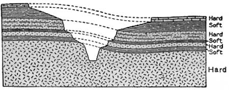
As both the character of a country and its scenery depend entirely upon the kind of rocks in it and upon their relations to one another it is well, perhaps, to outline briefly the essential features of the geology of this region before attempting to describe the valley of the Gunnison. The most striking element of the scenery along both lines of the Denver & Rio Grande Western is the very old granite and gneiss that are exposed in the Royal Gorge, the Eagle River canyon, and the canyon of Colorado River, on the main line, and in the Black Canyon and adjacent parts of the Gunnison Valley. These rocks, which are without true bedding, have been crushed and folded until their structure is generally very complex. After they were crumpled they were planed down by the action of the weather and the streams until their upper surface was fairly even and probably lay near sea level. The land sank somewhat irregularly, and on the smooth slopes of the granite were laid down sand and gravel, which later became sandstone and conglomerate. Upon these rocks other sediments, which became shale and limestone, were afterward deposited. Some of these rocks are of Cambrian age (see the table, p. II), and some are as late as Upper Cretaceous. These rocks then passed through many changes caused by uplift and erosion and probably during several epochs were planed down by the streams almost to sea level. The latest movement in the earth's crust has been one of elevation, which lifted the region to its present position, many thousands of feet above the sea, where the streams are vigorously attacking the rocks and cutting broad valleys or deep canyons, the results of their action depending on the kind of rock they encounter. A stream may at first cut down through relatively soft limestone and shale and may then encounter the massive granite, so that the top of the canyon may be broad and have gentle slopes (see fig. 45), whereas the bottom may be no wider than the stream that has cut it and may have practically vertical walls. The planing down of the granite has made the surface of the land adjacent to the tops of most of the narrow canyons flat—in other words, the streams have cut trenches in mesas or plateaus.
|
| FIGURE 45—Section showing the effect of hard and soft rocks on the form of a canyon. |
In the Gunnison Valley another chapter has been written as an episode in the geologic history of the general region—a chapter recording events of a time, after the sedimentary rocks had been deposited, when the region was covered with lava flows or with material derived from them or from volcanic eruptions.
From the summary of the geologic history of the region just given the scenery below the town of Gunnison, even including that in the Black Canyon, may be more readily interpreted. The country for a few miles below the station at Gunnison must have been at some time long past flooded with lava. The volcanic rocks thus formed are now generally soft, but in places, as on the upland southwest of the station, they rise above the general level in great monuments or spires, making a very rough country. (See Pl. LXX, B.) The character of the volcanic rock—a breccia—which composes much of the surface where the slopes are smooth, may be seen in the cut at milepost 290.
Wherever the granite appears above the level of the streams they have cut into it narrow canyons, above which the slopes may be very gentle up to some horizontal bed of sandstone, which generally stands out as a mesa cap. Where the slopes are gentle and the valley is broad hay fields abound, but where the valley narrows down to a canyon the bottom can not be cultivated.
The first large canyon below Gunnison begins at a siding called Hierro (yay'rro; Denver 294.5 miles), where the top of the granite stands at track level. The top of the granite rises downstream, and within a short distance below the siding the train passes through a pretty little winding canyon, whose granite walls range in height from 100 to 150 feet. The scenery in this canyon is not grand and striking, like that in the Black Canyon, farther down, but many beautiful views may be obtained of the clear; sparkling river, the fringe of willows and cottonwoods, and the gray canyon walls. The canyon ends at Elkhorn (Denver 297 miles), a resort devoted entirely to the followers of Izaak Walton. Below this place the canyon widens out, the granite decreases in height above the stream, and the slopes above the granite include horizontal beds of sandstone, so that they are made up of a number of mesas or terraces. Hay ranches abound in the broad valley, and opposite the village of Iola even the terrace formed by the granite about 50 feet above the bottom of the valley has been irrigated and yields flourishing crops.
|
Iola. Elevation 7,450 feet. Population 111.* Denver 299 miles. Cebolla. Elevation 7,354 feet. Denver 307 miles. |
A mile and a half below Iola another granite canyon begins, and in a short distance its walls rise to a height of about 150 feet. From the point of greatest height the walls decrease gradually and finally disappear near the mouth of Elk Creek, a small stream that joins Gunnison River from the north. The granite, however, does not completely disappear but extends down to milepost 306, or 1 mile above Cebolla (say-bo'yah), where it passes below water level.
Cebolla, which is one of the most noted resorts on the river for fishermen, is in a wide part of the valley on the north side of the river, at a mesa known as Tenderfoot Hill. The top of this mesa is 1,200 feet above the track at Cebolla. The granite does not remain below river level any great distance, for within a mile of Cebolla it forms the walls of a narrow canyon, which, however, are not more than 100 feet high. The smoothness and regularity of the upper surface of the granite and the way in which it rises and falls with reference to river level make it comparatively easy for the traveler to understand how the Black Canyon has been cut. It is evident that at the time the river established its course the granite in neither of the small canyons so far described nor in Black Canyon was exposed, for the river was then flowing on the softer sedimentary rocks that overlay the granite. As the river cut deeper into its bed it uncovered the granite, but it could not shift its course and thereby avoid the hard rock, so it had to keep at work laboriously cutting its way into the granite. Although the granite canyons about Cebolla are now shallow, they will become deeper and deeper in course of time until the entire route from Gunnison to Cimarron may be one granite canyon as deep and as impressive as the "Black Canyon." It may be well to say that this great canyon will not be seen by the coming generation nor the generation after the next, nor even the one following that; but the geologist knows that unless conditions change such a canyon will be formed, although the time may be thousands or millions of years hence.
Below Cebolla the canyon is much the same as it is above that place, except that the slopes above the granite become greater and in places are composed of vast masses of volcanic breccia that weather into fantastic forms. Where the granite is above the level of the river the canyon is more or less rugged, but where it is below the surface the valley is wide and the slopes are smooth and gentle.
|
Sapinero. Elevation 7,255 feet. Population 103.* Denver 314 miles. |
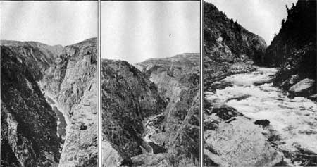
Near milepost 313 the granite passes below the level of the river and remains concealed as far as the village of Sapinero (sah-pe-nay'ro), which is a noted fishing resort and the junction of the branch railroad. that runs southward 36 miles to Lake City. From the station at Sapinero the traveler, by looking back, may obtain an excellent view of a great cliff of volcanic breccia (see Pl. LXX, A), and by looking forward he may see the granite rising athwart the pathway of the stream; but even this hard rock has not proved to be an insuperable barrier to the stream, which has trenched it in Black Canyon seemingly as easily as if it had been soft shale.
The Lake City branch follows the main line for a mile and then turns to the southeast (left) up Lake Fork. It was nearly to this point that Capt. Gunnison followed the river in 1853, but finding that the canyon below was apparently impassable, he turned to the south, then struck westward across the mesas to the Uncompahgre Valley, at the site of Montrose. The automobile roads also avoid the canyon. The main road divides at Sapinero, one branch following the route of Capt. Gunnison and rejoining the railroad at Cimarron (sim-ah-rrohn'), and the other climbing west of Sapinero to a bench on the slope about 500 feet above the station and then following this bench on the brink of the canyon for an air-line distance of over 6 miles. Next it climbs to the top of the Black Mesa and avoids the lower canyon by a long detour to the north. This road affords one of the most striking and picturesque drives in the State. At the point where it leaves the canyon it is fully 1,000 feet above the roaring stream, and, as shown in Plate LXXI, A, B, the walls appear to be vertical. Gunnison River is still actively engaged in cutting its canyon deeper, as shown by the rapid current (see Pl. LXXI, C) and the roughness of the water as it rushes down the rocky bed.
|
|
PLATE LXXI. A, B. (left and center) BLACK CANYON OF THE GUNNISON
SEEN FROM ABOVE. Views from the automobile road that follows the brink
of the canyon for several miles. This canyon is a close rival of the
Royal Gorge and like it may easily be seen from both the top and the
bottom. These pictures show the even surface of the plateau in which
the canyon is cut. Photographs by Willis T. Lee. C (right). ROUGH WATER IN BLACK CANYON. When seen from the rim of the canyon Gunnison River appears like a placid brook, but a nearer view dispels this idea. Photograph by Marius R. Campbell. |
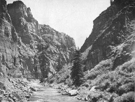
Black Canyon is noted for its awe-inspiring beauty. Of the canyons which the traveler sees on the lines of the Denver & Rio Grande Western Railroad, the Royal Gorge easily holds first place, but the Black Canyon as a scenic feature is a close second. The form of this canyon, like that of the Royal Gorge, depends on the character of the granite or gneiss. Where the rock is massive the walls are unbroken and nearly vertical, but where the rock is banded and composed of layers of different hardness, as it is in most places, the walls may recede gradually and be very jagged and irregular. Some irregular walls are shown in Plate LXXII.
|
| PLATE LXXII. UPPER PART OF BLACK CANYON. The rough granite walls are about a thousand feet high. The beautiful stream of clear, sparkling water tempts the traveler to stop and try his luck at casting a fly. Photograph furnished by Denver & Rio Grande Western Railroad. |
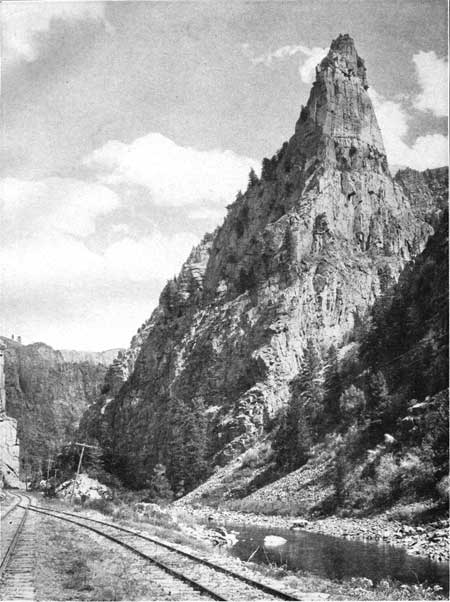
At the mouth of Lake Fork the canyon walls are about 200 feet high, but their height increases downstream, until at the siding of Curecanti they are 1,000 feet high. Every curve and angle in this distance presents a different aspect, and it is difficult to say which view is the finest. One of the most striking scenes is that of a pinnacle left standing at the mouth of Blue Creek, a small stream that joins the river from the south. This pinnacle has been named Curecanti Needle. It is nearly 1,000 feet high and is a striking object as seen from the railroad siding. (See Pl. LXXIII.)
|
| PLATE LXXIII. CURECANTI NEEDLE. The most striking object in Black Canyon is Curecanti Needle, a pyramid of granite 800 or 900 feet high, standing at the mouth of Blue Creek. Photograph furnished by the Denver & Rio Grande western Railroad. |
The appearance of Black Canyon, like that of most features of the kind, depends largely upon the light and the condition of the atmosphere. When seen in bright sunlight, as it generally is, it presents a view that is bright and lively. The rocks of the walls are full of color, and the trees and shrubs add to the beauty of the scene. But in dark and stormy weather the canyon becomes forbidding; it loses its color and becomes terrible to look upon. It is at its best in the evening, when the purple shadows that begin to play behind each projecting buttress present a strong contrast to the yellow sunlight on the westward-facing walls. Later the high points alone are bathed in yellow light, and the canyon slumbers in a mantle of blue light, steely above but denser in the seemingly unfathomable lower reaches.
Below Curecanti the canyon is even more wonderful. In general the walls are not so nearly vertical, but they increase rapidly in height until at a point 2 miles above the mouth of Cimarron Creek they are fully 2,500 feet high. The river, which is beautifully clear, becomes rougher as it descends, as shown in Plate LXXI, C, until it presents an almost continuous series of cascades.
A short distance above the mouth of Cimarron Creek the railroad crosses the river on a high bridge and there turns and runs up Cimarron Canyon, to the south, for this is as far as a railroad can be carried in Black Canyon without going entirely through the worst part of the canyon, and such a course would entail an expense that no ordinary railroad could meet.53
53Although Black Canyon below the mouth of Cimarron Canyon is comparatively small, in both depth and length, it is one of the most difficult to traverse, and very few travelers have succeeded in passing through it.
The Black Canyon was first explored by a party of engineers of the Denver & Rio Grande Railroad, who in 1882-83 made an instrumental survey of the entire canyon, even passing through the more difficult portion below Cimarron. No records of this trip, so far as the writer is aware, have ever been published; all we know about it is that the members of the party suffered great hardship and peril. Since that time others have attempted to traverse the canyon below Cimarron, but most of them have suffered shipwreck and disaster.
About 1903 A. L. Fellows, an engineer of the Reclamation Service, and W. W. Terrence, of Montrose, made the attempt. They were equipped with a rubber raft, rubber bags for cameras, and two silk life lines 600 feet long. They lost their provisions but succeeded in capturing a mountain sheep, upon which they lived during the rest of their trip. It took them 10 days to traverse 30 miles of the canyon.
More recently Ellsworth Kolb has made a successful trip through the canyon, so that it seems probable that the Gunnison has been tamed or that man has learned how to circumvent even this raging torrent.
|
Cimarron. Elevation 6,905 feet. Population 57.* Denver 329 miles. |
If the traveler were not satiated with canyons he would doubtless think that Cimarron Canyon is wonderful, but after traveling for 14 miles in the rocky depths of Black Canyon he longs for the free air and for the larger view which the hilltops alone can give, and the sight of the station of Cimarron nestling beneath the spreading branches of giant cottonwoods is therefore most welcome. From the station it is impossible to determine why the canyon has come to an end and why one can look out through the trees into open country beyond. This change, like many others, is due to the geology, and it can be better understood by the traveler when he is at least part way up the long grade to Cerro Summit. At Cimarron the automobile road on the south side of the river joins the railroad, and together they climb to the summit on their way to Uncompahgre Valley.
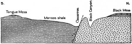
Immediately after leaving Cimarron the traveler will see that, so far as the surface features are concerned, he is in an entirely different world. He has just passed through a region of the hardest rocks, where he could see little if any soil, but here he can see no rock, at least nothing that resembles the rocks of the canyon, though on closer examination he will see that the rock is the softest kind of shale—the Mancos shale. He may also notice that the contact between the rocks of the canyon and those of the plain is extremely abrupt, and if he could follow that contact he would find that the same beds are not in contact at all places. This variability in contact indicates that the rocks of the plain and those of the canyon are separated by a fault. In other words, the hard rocks of the canyon have been broken away from their fellows down below and lifted until they now stand actually higher than the shale, as shown in figure 46. This fault has been traced for a long distance, and in all places the edges of the sedimentary rocks are in contact with the granite. (See Pl LXXXVII, A, B, p. 216.)
|
| FIGURE 46.—Section across Black canyon at Cimarron. The rocks have broken along the fault shown in the section, and the granite on the north has been forced up far above its original position. |
After leaving Cimarron the train begins its steep climb to the divide which separates the drainage of Cimarron Creek from that of Uncompahgre River. This grade, which is one of the steepest grades on the road, is 4 per cent, or 211 feet to the mile. In making this climb the traveler will notice that the hard rocks through which the Gunnison has cut its canyon form a large, high mesa on the north (right), considerably higher than the summit over which the railroad passes. The shale was once probably at least as high as the granite, but it is so much softer that it has been worn away until it now lies distinctly below the hard rocks. It would thus seem that Gunnison River has gone out of its way to cut its canyon through the highest land and the hardest rocks in the region. This statement, however, represents merely the conditions as they appear to-day, but when Gunnison River first assumed this course it must have been flowing on the lowest land or it could not have remained there. At that time all this country probably stood at a much lower level and was nearly a plain, the hard rocks having been worn down as low as the soft rocks. Under such conditions the river found it as easy to flow over the granite as over the shale, and so its course was not in any sense abnormal.
|
Cerro Summit. Elevation 7,968 feet. Denver 335 miles. |
In making the climb to Cerro Summit the traveler will see on the south (left) the great mass of Tongue Mesa, which owes its preservation to a protecting cap of hard rock that was originally lava which came down from some of the numerous volcanoes in the San Juan Mountains, to the south, which are visible from the open valley near Montrose. The traveler is now approaching one of the most arid parts of Colorado, where water is the most valuable natural resource. In order to irrigate a part of the great Uncompahgre Valley, which lies ahead, a long ditch has been dug to take water from far up on Cimarron Creek, carry it across Cerro Summit at a higher point than the railroad, and distribute it on the slopes to the west. Where this ditch crosses the summit it forks, and the right-hand branch, known as the Montrose and Cimarron ditch, passes under the railroad at the summit and is carried a long distance to the northwest to irrigate the broad terrace which the traveler will see later.
From Cerro Summit and the slopes beyond an extended view to the west may be obtained across the broad Uncompahgre Valley to the great Uncompahgre Plateau beyond. The ride down the slope is not particularly interesting, except as the traveler unfamiliar with the semiarid regions may see what it means to get water onto the land. The effect of irrigation is well illustrated by the verdant terrace which the traveler may see on the right at an altitude of at least 1,000 feet above the middle of the valley at Montrose. Where water is not available the surface is a desert, but where the land is supplied with all the water it needs, it will support a luxuriant vegetation.
|
Cedar Creek. Elevation 6,752 feet. Denver 341 miles. |
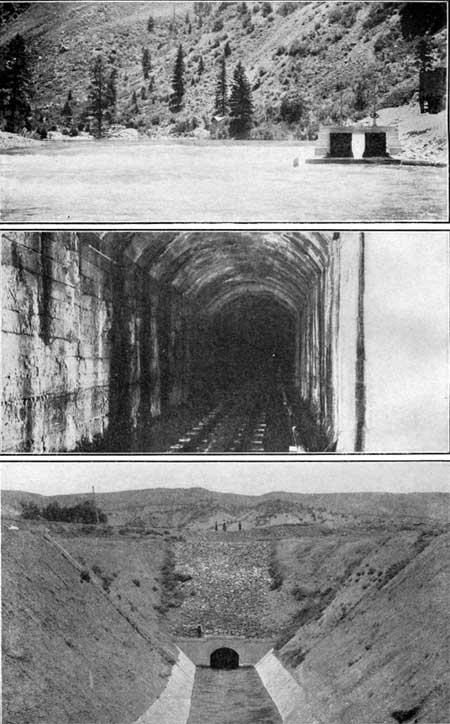
For a long time private enterprise was engaged in irrigating small parts of the Uncompahgre Valley from such streams as Cimarron Creek and Uncompahgre River, but these were found to be entirely inadequate for the irrigation of the entire valley. It was then decided to tunnel through Vernal Mesa (the granite mesa on the right) and bring the waters of Gunnison River to the region. The attempt was made, but funds could not be obtained to complete the project. The Reclamation Service then took up the problem and a tunnel was started a mile below Cedar Creek and continued to the river in the almost inaccessible depths of Black Canyon, a distance of 6 miles. Work was begun in 1905, and the tunnel was formally opened by President Taft in 1909. Views of the two portals and the interior of the tunnel are shown in Plate LXXIV. By this tunnel sufficient water to irrigate 150,000 acres was obtained.54
54The settlement of the Uncompahgre Valley, which has had many ups and downs, began in 1882 and for a while progressed rapidly. Optimistic views on the sufficiency of the supply of water from Uncompahgre River prevailed, and by 1884 ditches for irrigating a large acreage had been projected and partly constructed. It soon proved that the water supply was in adequate, and 20,000 acres out of the 100,000 acres that had been patented passed into the hands of loan companies through foreclosure proceedings. About 30,000 acres was cultivated, but the water supply was inadequate for even this small area. In a search for an additional supply naturally Gunnison River was considered, but in order to obtain water from that river a long and expensive tunnel was necessary, yet this seemed to be the only possible chance for relief. The feasibility of the project was demonstrated in 1895 by a survey financed by local subscription. In 1901 the State appropriated $25,000 and work was begun on the great tunnel. A year later, when the appropriation had been exhausted, the State and citizens requested that the Reclamation Service complete the project. Upon examination the Reclamation Service found a better site for the tunnel, and on June 7, 1904, the Secretary of the Interior ordered the construction to begin.
The Gunnison tunnel, as finally built, is 30,645 feet long (about 5.8 miles) and has a uniform grade of 10.7 feet to the mile. The bottom is flat and is 10 feet wide, the straight sides are 10 feet high and batter outward 6 inches, and the roof is arched with a span of 11 feet and a rise of 2-1/2 feet. The flow of water that can be delivered through the tunnel is estimated at 1,300 second-feet.
Excavation was begun on January 11, 1905, and was carried on at both ends and from a shaft 1 mile from the west portal. The tunnel complete, with concrete lining, was finished and water for irrigation was flowing through it on July 6, 1910.
It is interesting to note that this tunnel passes through the fault shown in figure 46 (p. 175), at the contact of the shale which constitutes the country rock in the western part and the granite in which the river canyon is cut. It is described in the report of the Reclamation Service as follows:
"[The tunnel was driven] 2,000 feet through a fault zone badly shattered and tilted at widely divergent angles in a very irregular manner. High temperature, hot and cold water, coal, marble, hard and soft sandstone, limestone, and carbonic-acid gas in overwhelming quantities were encountered in this section, and tunnel excavation was both difficult and dangerous."
This description shows how rocks may be broken and jumbled together in a fault zone where they have moved hundreds or perhaps thousands of feet.
|
| PLATE LXXIV. GUNNISON TUNNEL OF THE UNITED STATES RECLAMATION SERVICE. The driving of a tunnel 6 miles through the solid rock so as to bring some of the mountain water of Gunnison River to irrigate the Uncompahgre Valley is one of the great works accomplished by the Reclamation Service. A, Diversion dam and intake in Black Canyon; B, Interior of tunnel; C, West portal of the tunnel, Photographs by the U. S. Reclamation Service. |
From the west end of Gunnison tunnel the water is carried to Uncompahgre River by a canal 11 miles long. It is turned into the channel of the Uncompahgre at a point 9 miles above Montrose and is diverted lower down for projects on both the east and the west side of the valley.
At the end of 1920 water from the Gunnison tunnel was used in irrigating 65,000 acres of land which, before the completion of the tunnel, was a barren desert waste. The principal crops are alfalfa, oats, wheat, potatoes, apples, and sugar beets, listed in decreasing order of the acreage cultivated. Small fruits, onions, sugar beets, apples, garden products, and potatoes, in the order named, gave the largest returns per acre.
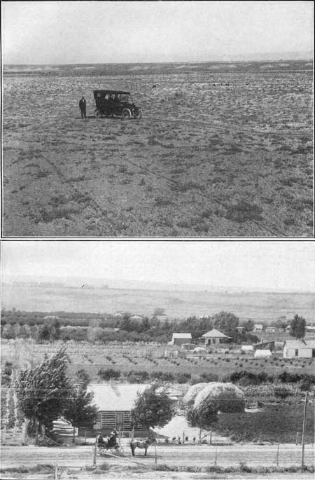
After passing the Gunnison tunnel, which, unfortunately, is not visible, the train descends the sloping side of the broad valley in a barren ravine, but at a siding called Fairview, half a mile beyond milepost 346, irrigated farms are spread out on both sides of the railroad. The crops that are growing here will, of course, depend upon the time of year in which the journey is made. If the traveler passes this place in midsummer he will see fine fields of oats and wheat, some corn, and plenty of potatoes, sugar beets, onions, and alfalfa. He will also see a few orchards, but this particular area is not largely devoted to fruit raising. The valley has been transformed, as shown in Plate LXXV, A, B, from a wilderness to a region of prosperous farms, and the secret of the change is only water.
|
|
PLATE LXXV. A (top). UNCOMPAHGRE VALLEY IN ITS NATURAL STATE.
The land in the Uncompahgre and Colorado River valleys before water is
turned upon it is a barren expanse of adobe soil on which there is only
a scanty growth of plants. It is inhabited only by jackrabbits, coyotes,
and other animals having great endurance and ability to travel a long
distance for water. Photograph by the U. S. Reclamation Service. B (bottom). THE SAME VALLEY IRRIGATED. The transforming effects of the Gunnison water are seen in the fine farms and happy homes of the Uncompahgre Valley, where once there was nothing growing but sagebrush and greasewood. |
In the journey down the long tangent to the middle of the valley the most striking features of the landscape are the rugged peaks of the San Juan Mountains, which are visible to the south (left). These mountains are the most rugged in the State. Most of the peaks are over 13,000 feet high, and many of them rise above 14,000 feet. The highest point in the range is Uncompahgre Peak, which has an altitude of 14,419 feet. The sawtooth top of this range is well shown in the profile visible from the train.
|
Montrose. Elevation 5,811 feet. Population 3,581. Denver 352 miles. |
After passing through miles of the finest farms in the West the train reaches Ouray Junction, which is the point where this line joins the one from Ouray, Telluride, and Durango. Here the railroad turns at a right angle and proceeds a mile northward to the station in the growing young city of Montrose. This city is the distributing center and shipping point for a large district that is under high cultivation. Cereals, fruits, and vegetables, together with forage plants, grow here in abundance. Two miles south of Montrose was the home of Chief Ouray, for whom the peak north of Marshall Pass and the mining town in the San Juan Mountains were named. The main line and the branches of the railroad north of Montrose were changed to standard gage in the summer of 1906.
| <<< Previous | <<< Contents >>> | Next >>> |
bul/707/trip5.htm
Last Updated: 16-Feb-2007