
|
Geological Survey Bulletin 845
Guidebook of the Western United States: Part F. Southern Pacific Lines |
ITINERARY
|
|
SHEET No. 14 (click in image for an enlargement in a new window) |
|
Longfellow. Elevation 3,379 feet. Population 30.* New Orleans 891 miles. |
A few miles beyond Longfellow the tracks deflect to the south. Highway 3 continues west up the Dry Creek Valley to a divide somewhat higher than the one utilized by the railroad. The railroad follows a wide valley, which is drained in part by Sanderson Creek and beyond Rosenfeld siding by Maxon Creek. The walls of the valley consist of the Edwards and Georgetown limestones, which crop out in massive gray ledges.
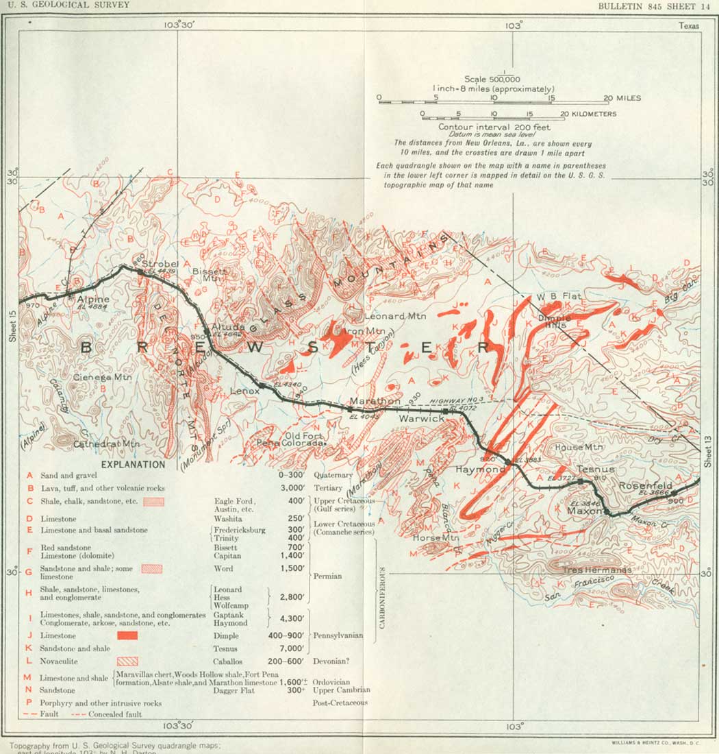
Near Maxon siding a prominent ledge of brown sandstone 100 feet thick appears beneath the Edwards limestone in the canyon walls and is in turn underlain by impure limestones and shales of the Glen Rose formation of the Trinity group, which crop out in a succession of benches and slopes, as shown in Figure 9. The walls are 300 to 500 feet high near Maxon, but they are mostly broken into ridges and buttes. Maxon is near Maxon Springs, named for Lieutenant Maxon, of the United States Army, who first described it.
|
| FIGURE 9.—Section near Maxon, Tex. Cretaceous; Kg, Georgetown limestone; Ke, Edwards limestone; Kwc, Walnut and Comanche Peak limestones; Kss, sandstone; Kgr, Glen Rose formation. Pennsylvanian: Ct, Tesnus formation. |
Three miles beyond Maxon the railroad swings to the west and, leaving the limestone canyon, enters a broad plain out of which rise many ridges of moderate height. This is the eastern edge of the Marathon Basin. A short distance east of Tesnus siding the railroad passes onto strata of Paleozoic age, which underlie the limestones and shales of the Trinity group. The Paleozoic rocks exposed near Tesnus siding are sandstones and shales of the Tesnus formation, of Pennsylvanian age, of which this is the type locality. It gives rise to rounded hills, on which are many russet-brown outcrops of the sandstones.
|
Tesnus. Elevation 3,725 feet. New Orleans 911 miles. |
The Marathon Basin, which is entered near Tesnus, is an area of plains and low ridges about 40 miles wide, in which rocks of Paleozoic age are extensively exposed.62 It is surrounded on all sides by escarpments of the limestones of Cretaceous age which formerly extended entirely across the region but have been removed by erosion from the area of the Marathon Basin. The basin occupies the truncated crest of the Marathon uplift, a great dome in the earth's crust, by which all the strata have been uplifted 4,500 feet or more in an area about 100 miles in diameter. The east side of this dome is crossed between Longfellow and Tesnus, where the canyon walls expose successively lower parts of the Comanche series and finally the underlying rocks of Paleozoic age. This is caused by the westward rise of the strata toward the crest of the Marathon dome.
62The following table and description of the Paleozoic formations exposed in the Marathon Basin are furnished by P. B. King:
Age Formation Thickness
(feet)Character Pennsylvanian series. Gaptank formation. 1,800 Limestone, interbedded with shale, sandstone and conglomerate. Exposed only on north side of Marathon Basin, where it is overlain by the Permian. Haymond formation. 2,500 Thin-bedded sandstone and shale, with thick beds of arkose and boulder conglomerate in upper part near Haymond siding. Dimple limestone. 400-1,000 Limestone and interbedded shale, cropping out in low, narrow ridges. Tesnas formation. 7,500 Thick-bedded brown sandstone, with some interbedded shale, with a member of dark shale at the base several thousand feet thick. Devonian (?) system. Caballos novaculite. 200-600 Novaculite and chert, which crop out in prominent ridges. Ordovician system. Maravillas chart. 100-400 Black chert and limestone. Woods Hollow shale. 500 Drab shale, with interbedded flaggy brown sandstone and limestone. Fort Peña formation. 150 Massive limestone, bedded reddish chert, and some conglomerate. Alsate shale. 50 Shale and thin limestone beds. Marathon limestone. 500-800 Flaggy gray limestone, with a thin medial member of cherty dolomite; much shale and some conglomerate. Cambrian system. Dagger Flat sandstone. 300+ Shale with thin brown limestone and sandstone beds, passing down into massive sandstone.
The Cambrian and Ordovician rocks differ considerably from those in the region of Van Horn and El Paso, only a few hundred miles away, where the basal sandstone is overlain by several thousand feet of Ordovician and Silurian limestones. Near Marathon there is much sandstone, shale, and conglomerate in addition to limestone. The fossils are also different. The Ordovician rocks at Marathon contain chiefly graptolites and linguloid brachiopods, animals which lived in an environment of turbid water; the Ordovician strata at El Paso and Van Horn contain cephalopods, gastropods, and sponges, which lived in a clear sea where limy sediments were being deposited. These differences are due to differences in local conditions, and it is probable that the sediments in the Marathon region were deposited closer to an old shore line than those in the El Paso and Van Horn regions.
The Pennsylvanian rocks also give evidence of a shore line near the Marathon region in Paleozoic time. They are very thick and consist almost entirely of shale and sandstone, with some beds of conglomerate. Marine fossils are not very abundant, except in the highest formation, and the lower formations are characterized chiefly by the remains of land plants. It is probable that the sand and clay of the Pennsylvanian were washed down from high lands to the southeast and were deposited in a series of deltas along the shore line. The three older Pennsylvanian formations are regarded as of Pottsvile age, and the fossil shells in the upper formation are like those of the well-known upper Pennsylvanian (post-Pottsvile) strata of Kansas and central Texas.
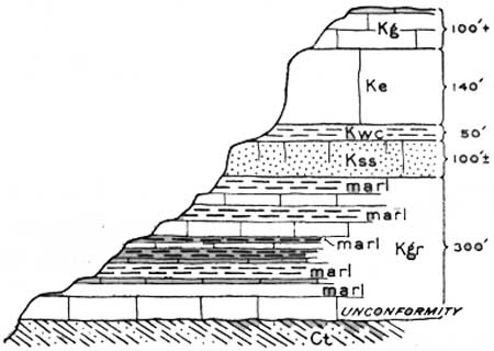
Near Tesnus the strata of the Comanche series are cut off by erosion and present high, westward-facing escarpments which rise far above and afford fine views of the Marathon Basin lying below them to the west. In places, also, they constitute more or less isolated outlying buttes and mesas, west of the main escarpment. The most prominent part of the escarpment near the railroad is House Mountain, which lies north of the tracks a few miles west of Tesnus. This broad cuesta (elevation 5,460 feet) has a steep face on the west and rises 1,500 feet above the plains at its base.63
63The upper part of House Mountain consists of Comanche limestone dipping gently to the east, and the lower slopes consist of russet-brown sandstone and shale of the Tesnus formation (Pennsylvanian), which dips about 45° SE. The strata of the two series thus present a great angular unconformity, which is clearly revealed on the escarpment as shown in Plate 13, A. Some of the relations here and farther west are shown in Figure 10. The mass of older rocks is beveled to a nearly perfect plain on which the Comanche strata lie.
FIGURE 10.—Section through House Mountain, about 1 mile north of the railroad northwest of Tesnus. Tex.
The Paleozoic rocks in the vicinity of House Mountain acquired their steep inclination as a result of folding during the later part of the Paleozoic era, which involved the entire area of Paleozoic rocks in the Marathon Basin and probably far beyond. The folds have a northeastward trend. At the time of the folding there was faulting in places. Some of the faults dip at low angles to the southeast and are planes along which blocks of the Paleozoic rocks have been displaced for many miles to the northwest. The folds in these Paleozoic rocks are like those in the Onachita and Appalachian Mountains and were formed at about the same time. After Paleozoic time the folded rocks of the Marathon Basin were beveled by running streams and the general processes of weathering, and in later Mesozoic time the Lower Cretaceous sediments were deposited on their upturned edges. The deformation of the Cretaceous sediments and the development of the Marathon uplift occurred long afterward.
Within the Marathon Basin the Paleozoic rocks constitute low, sharp ridges far inferior in magnitude to the mountains that must have existed when the folding of later Paleozoic time took place. The present low ridges were produced by erosion in post-Cretaceous time, after the Marathon dome was uplifted and the Cretaceous rocks were eroded from the area of the Marathon Basin.
|
|
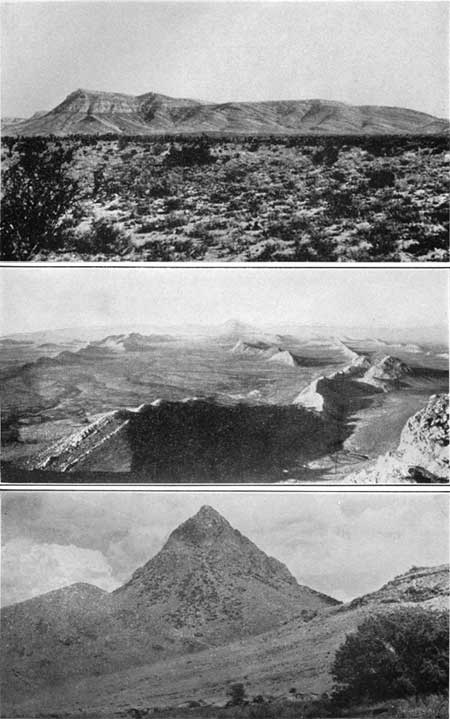
PLATE 13. A (top), CONTACT OF OVERLAP OF COMANCHE LIMESTONE ON
TILTED STRATA OF PENNSYLVANIAN AGE NORTHWEST OF TESNUS, TEX. (P. B. King.) B (center), SINUOUS RIDGES OF HARD BEDS IN MARATHON BASIN (P. B. King.) C (bottom), MITRE PEAK, 6 MILES NORTHWEST OF ALPINE, TEX. A mass of igneous rock, probably an outlet for lavas in the surrounding region. |
Another outstanding promontory lies south of Tesnus and comes into view a short distance beyond Maxon. Merging into the plateau near Maxon at an elevation of 3,700 feet, in 6 miles it rises considerably higher to its western termination, where it breaks into three peaks known as Tres Hermanas, each capped by a small mass of Edwards limestone. The ridge stands 1,300 feet above the plains to the north, but its steep southern front rises 2,000 feet above the valley of San Francisco Creek.
The sharp ridges of the basin, underlain by hard rocks, extend across it in a northeastward direction. Some of them run nearly straight for many miles; others have a winding course, as shown in Plate 13, B, expressing the complex deformation of the strata. On many of the ridges are ledges of white siliceous rock called novaculite. Between the ridges are wide valleys covered by soil and gravel, but along the larger drainage ways the land is cut by many arroyos into a maze of terraces and shallow, steep-walled valleys. Much of the terraces gravel consists of white novaculite and has the appearance of drifted snow.
West of Tesnus Horse Mountain is prominently in view 10 miles to the southwest. This is the highest peak in the Marathon Basin (elevation 5,010 feet) and is a dome-shaped mass of novaculite of anticlinal structure. The railroad crosses a level plain for several miles west of Tesnus and then descends into a region of hills and valleys, drained by San Francisco Creek.64
64A few miles beyond Tesnus the railroad crosses a fault, not visible from the tracks but well exposed some miles to the north and south, which brings the Tesnus strata against the higher part of the Haymond formation occupying a syncline. The highest exposed member of this formation, also concealed by gravel near the railroad but well exposed in slopes not far away, is a remarkable conglomerate containing rounded and angular masses of rocks of many kinds, most of which do not crop out in the Marathon area. The fragments are rather widely set in a matrix of arkosic mud and consist of cobbles of pre-Cambrian gneiss, granite, schist, aplite, and pegmatite, large angular blocks of Upper Ordovician limestone, Devonian chert and novaculite, Tesnus quartzite, Dimple limestone, gray limestone with fossils of middle Pennsylvanian age, and siliceous breccia, probably a fault breccia. Blocks 5 to 15 feet across are common, and one block of Dimple limestone south of the railroad is over 100 feet long. The large masses, however, are most abundant a mile or more north of the railroad.
The various pre-Cambrian to Carboniferous ingredients in this conglomerate indicate that there was a near-by area of upturned older strata in upper Haymond time. Probably it was situated south of the present uplift and is now deeply buried beneath younger strata. It is difficult to understand how the coarse materials were transported to their present position, for the larger masses could not have been carried by ordinary streams; they may have been overthrust—a condition that might account for the presence of the blocks of fault breccia.
Beyond the edge of the gravel plain 5 miles west of Tesnus thin bedded sandstone and shale of the Haymond formation are exposed in some of the railroad cuts, and the massive arkose, which directly underlies the boulder bed, crops out in conspicuous ledges along the edge of the valley not far to the south. After crossing the Haymond beds the railroad follows the gap cut by San Francisco Creek across the sharp, narrow ridge of steeply tilted Dimple limestone, a ridge typical of the outcrops of this formation throughout the Marathon Basin, and continues down the valley past Haymond, which is on an anticlinal area of Tesnus sandstone, some ledges of which are well exposed along the railroad and creek.
|
Haymond. Elevation 3,883 feet. New Orleans 919 miles. |
Haymond siding, which lies in the valley of San Francisco Creek, is now a very small place but was at one time a town of considerable size. It was the railroad station for Fort Stockton, 60 miles to the north, when that was an important frontier fort. The rocky hills near Haymond are underlain by various formations of Pennsylvanian age. To the east and west of it are low ridges of the Dimple limestone, between which are lower lands underlain by sandstones and shales of the Tesnus and Haymond formations. These rocks are folded into several sharp anticlines and synclines.
Northwest of the ridges of Dimple limestone the railroad again enters a much gullied plain of terrace gravel, underlain by sandstones and shales of the Tesnus formation. The Caballos novaculite (Devonian?), which lies beneath the Tesnus, crops out to the northwest, about 3 miles beyond Haymond, in low ledges and ridges. This novaculite is a white siliceous rock, probably a variety of chert, in more or less massive-bedded layers. The name was applied to closely similar "whetstone rock" in Arkansas by Schoolcraft in 1819. Novaculite is of rare occurrence in this country, in comparison to such other sedimentary rocks as sandstone, shale, and limestone. The novaculite that crops out in ridges northwest of Haymond, here about 300 feet thick, lies on the northeast end of a great anticlinorium (an anticlinal arch with subordinate flexures) which brings pre-Pennsylvanian rocks to the surface over a wide area in the central part of the Marathon Basin. The strata of the anticlinorium are folded into several sharp anticlines and synclines and are broken by overthrust faults. Owing to its great hardness the novaculite is a ridge maker, and its white outcrops are very conspicuous.
Between the north end of these novaculite hills and Marathon the railroad crosses a flat gravel-covered plain. To the south are low hills of the novaculite, and to the north less conspicuous hills of Dimple limestone.
|
Marathon. Elevation 4,045 feet. Population 826. New Orleans 935 miles. |
Marathon is a village of considerable importance, named for a general of the United States Army who established a road from Fort Stockton to Presidio in 1854. It is a local center for large cattle interests and is the shipping point for the quicksilver produced at the mines of Terlingua, 70 miles to the southwest. These mines have been an important source of mercury since 1894 and produce 2,500 to 3,000 flasks (of 76 pounds) a year (Bureau of Mines). At one time a rubber factory was operated successfully at Marathon, making use of the guayule plant (Parthenium argentatum) as long as the local supply was available. Resin from the candillia plant has also been shipped from Marathon for use in making phonograph disks.
The village of Marathon is built on ledges of flaggy limestone and massive conglomerate of the Marathon limestone (Ordovician). This is the only pre-Devonian formation well exposed near the railroad, but in low hills not far south of Marathon there are extensive outcrops of strata from Cambrian to Devonian in age. West of Marathon low rugged ridges of Caballos novaculite may be seen to the south and behind them a high conical mountain of intrusive syenite, Santiago Peak, 25 miles distant (elevation 6,521 feet). To the west are the eastward-facing escarpments of the Del Norte Mountains, made up of limestones of the Comanche series, which form the western rim of the Marathon Basin.
Near Marathon and to the west the Glass Mountains are conspicuous to the north. The name is a translation of the Spanish Sierra del Vidrio, said to have been given because of the glassy appearance of the limestone cliffs when seen from a distance. According to Hill,65 however, the name Glass Mountains was first used for the novaculite ridges of the Marathon Basin and was later transferred through error to the mountains to the north, which had before been known as the Sierra Comanche. The Glass Mountains form the northern and northwestern rim of the Marathon Basin and have the form of a cuesta or sloping mesa which trends northeast. The southward-facing escarpments of these mountains rise 1,000 to 2,500 feet above the general level of the Marathon Basin and in the western part present a high broken crest of bold cliffs of dolomite, which attain an elevation of 6,500 feet.
65R. T. Hill, a pioneer in the geologic exploration of Texas, established the classification of the Cretaceous rocks in that State and mapped them over a wide area. His work on the physiography of Texas gave the first clear conception of the relations of the Edwards Plateau and of many other important topographic features of the State.
The Glass Mountains are carved from Permian dolomites, limestones, and shales, tilted northwest. These beds are overlain unconformably by the Lower Cretaceous strata and lie unconformably on the Pennsylvanian strata.66
66The following table, by P. B. King, shows the Permian formations of the Glass Mountains:
Formation Thickness
(feet)Character Bissett conglomerate. 700 Conglomerate of limestone fragments, with some red beds and limestone. Capitan limestone. 3,000 Massive dolomitic limestone, probably of reef origin, which grades eastward in part into thin-bedded limestone and westward in part into sandy limestone. Word formation. 1,200 Sandstone and siliceous shale, with thick beds of limestone. Changes eastward into cherty limestone. Leonard and Hess formations. 2,000 Sandstone and siliceous shale (Leonard), which change eastward into thin-bedded limestone (Hess). Basal conglomerate. Wolfcamp formation. 700 Shale end limestone; rests on strata of Pennsylvanian age, locally with great unconformity.
These formations show complex changes in lithologic character along the strike of the mountains. In the eastern half of the range nearly all the strata are limestone; in the western half there are also thick beds of sandstone and shale. These changes in lithology are shown in Figure 11. With the exception of the Bissett conglomerate, the Permian rocks of the Glass Mountains are all of marine origin. They contain a great variety of marine invertebrate fossils comprising foraminifera, sponges, corals, crinoids, ammonoids, gastropods, pelecypods, bryozoans, and a great number of brachiopods in which the Productus group greatly predominate. The brachiopods include several aberrant types, such as Leptodus and Richthofenia. A feature of the fossils in the Glass Mountains is their almost universal preservation by silicification. This replacement of the original shell material has proceeded in a most delicate manner, so that fine external ornaments and spines and minute internal structures are preserved. These are revealed by solution of the inclosing limestone by acid, which leaves the fossils in excellent condition. Eroded surfaces of these limestones are usually a tangled silicified mat of shells which accumulated on the sea bottom in Permian time. The faunas of the Glass Mountains are of the type known as the Guadalupian, which in North America is almost wholly confined to the west Texas Permian but in Europe and Asia is found in the typical Permian area. In the higher parts of the Glass Mountains section most of the limestones appear to have been built up of reef-making algae.
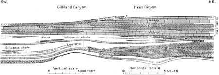
FIGURE 11.—Diagrammatic section showing lithologic variations in the Permian in the Glass Mountains, Tex. By P. B. King.
Six miles southwest of Marathon is old Fort Peña Colorada, which was located near a gap in a novaculite ridge, where there is a spring and one of the few streams of running water in the region. This was a station on both the military road east and west and the Comanche trail that led southward from Fort Stockton to the Rio Grande. At one time it was garrisoned with soldiers to protect travelers from Indians and outlaws.
About midway along the south edge of the Glass Mountains is the bald reddish knob of Iron Mountain, a stock of intrusive syenite which cuts across the Permian strata.
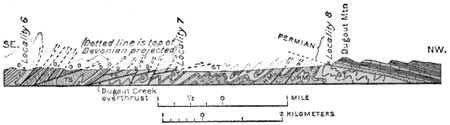
Four miles west of Marathon the railroad crosses low ledges of the Gaptank formation, which contains marine fossils of upper Pennsylvanian age. Several railroad cuts expose steeply dipping shale, sandstone, and conglomeratic limestone. About a mile to the south of the tracks are several low hills of novaculite and chert. In other novaculite hills, visible farther southwest, the novaculite has been overthrust onto the Gaptank formation by a fault, with the older strata in nearly flat contact. This displacement, called the Dugout Creek overthrust, had a horizontal movement of nearly 6 miles in a northwestward direction. Some of its relations are shown in Figure 12. North of the novaculite hills above mentioned and west of Lenox siding, the basal Permian beds are exposed in Dugout Mountain, resting on the steeply inclined and contorted Pennsylvanian rocks; as the Permian beds contain coarse conglomerates derived from the erosion of older rocks, the Dugout Creek overthrust is pre-Permian and probably later Pennsylvanian.
|
| FIGURE 12.—Section southeast of Dugout Mountain, Tex., showing relations of the Dugont Creek overthrust. By P. B. King. €, Cambrian; O, Ordovician; D, Devonian; TS, Tesnus formation; HM, Haymond formation; GT, Gaptank formation. |
Near Lenox siding the railroad passes between low hills of the lower Permian rocks, of which Dugout Mountain is one, and leaves the Marathon Basin. The high escarpment of the Glass Mountains comes into view to the northeast, behind lower foothills. The slopes of the escarpment are shale and sandstone of the Word formation, which are surmounted by cliffs of Capitan limestone. The most imposing exposure is on Cathedral Mountain, several miles northeast of the railroad. The limestone of the cliffs was probably built up in reefs on the Permian sea floor by calcareous algae and other organisms. These beds thin to the west, and on the scarp near the railroad near Altuda they are of negligible thickness.
|
Altuda. Elevation 4,642 feet. New Orleans 951 miles. |
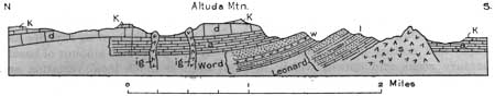
Altuda siding is in the pass or low, wide gap between the north end of the Del Norte Mountains and the southwestern extension of the Glass Mountains. For several miles in this vicinity there are excellent views of both ranges, which are very rugged and bare. Altuda Mountain, to the west, and Mount Ord (named for General Ord, one time commandant of the military forces in Texas), to the south, are especially conspicuous. Altuda Mountain is capped by Capitan limestone, which forms a prominent cliff on its upper slope. At one point, as shown in Figure 13, there is an outlying mass of Comanche limestone. South of Altuda Mountain the Word and Leonard formations are tilted steeply northward away from an intrusive mass of syenite, which forms a dark-colored knob west of Altuda siding. On the northwestern or back slope of the Glass Mountains, in view north of Altuda, remnants of Comanche limestone may be seen, resting on the Capitan limestone.
|
| FIGURE 13.—Section of Altuda Mountain, northwest of Altuda siding, Tex. By P. B. King. a, Altuda limestone; d, massive dolomite (Capitan); K, limestone of Comanche age; l, Leonard formation; w, Word formation; ig, intrusive dikes; s, syenite mass |
At Altuda the railroad runs nearly north to pass around the north end of the Del Norte Mountains and in the main is in a wide valley floored with alluvial wash from the adjoining mountain slopes. From this plain rise several knolls of the underlying rocks, which indicate faulted structure, though the details are hidden by sand and gravel. Near Strobel siding the north end of the Del Norte Mountains is passed and the structural relations are well exposed. Here heavy ledges of Edwards and Georgetown limestones, dipping west and cut by two faults, pass beneath Upper Cretaceous rocks, and these in turn under the great volcanic succession (Tertiary) which extends far west in the Davis Mountain region. In the valley just found of Strobel are ledges of chalky limestone of Upper Cretaceous age which pass under the lower sheet of the lava succession. Beyond Strobel, as the railroad ascends and passes around the curve, there are very fine views of the rugged peaks of the volcanic region, notably of Mitre Peak, (see pl. 13, C), which lies several miles northwest. There is a downgrade into Alpine over volcanic rocks of various kinds.67
67In western Texas the later formations of the Upper Cretaceous are largely sandstones which carry local coal beds and contain bones of land animals. Much volcanic ash and tuff erupted from near-by volcanoes is intermixed and interbedded in places. These strata are overlain by a great succession of lava flows, tuff, and agglomerate of volcanic origin, most of which is regarded as of Tertiary age. Sedimentary beds in this succession contain leaves of Eocene age (Berry), and bones of Miocene animals occur in higher beds (Baker). In eastern Texas marine conditions persisted long into the Tertiary period, but western Texas from late Cretaceous time was an upland with local basins of deposition and many volcanic vents, from which there were vast eruptions of lava and fragmental material. Prior to these eruptions the Cretaceous strata were flexed and faulted, and in areas of most pronounced uplift there was considerable erosion, for locally the volcanic rocks lie on deeply eroded surfaces of the deformed strata. These volcanic rocks present the record of various episodes of igneous activity continuing well into Tertiary time. They came from far below the surface through cracks and craters in the older sedimentary rocks and spread widely as lavas, varying considerably in composition, extent, and sequence. Apparently the largest eruptions were in early or middle Tertiary time. A vast amount of fragmental material was also thrown out of the numerous vents. This consists of agglomerate or breccia (made up mostly of coarse fragments of lava) and tuff (finer-grained ash and cinders), and there was also some fine-grained volcanic ash. Most of this ejected matter piled up in sheets as it fell, but in some places water had a part in its distribution, and from some of the vents there also came extensive mud flows. At intervals and from place to place there were great outflows of lavas of various kinds that extended far over the surface of the deposits of fragmental material and were in places buried beneath later eruptions of breccia, tuff, and ash.The lavas in this region are mostly of the varieties known as rhyolite and trachyte, with a small amount of basalt, but there is much local variation and great difference in the extent of individual flows. At the beginning of volcanic activity the configuration of the region was probably much smoother than it is now, for the old surface on which the volcanic deposits lie appears to be smooth at most localities. Several ridges of older rocks protruded, however, some of which were not covered by volcanic materials. After the main period of volcanic action in Tertiary time the region was uplifted and the sheets of lava and associated deposits were flexed, tilted, and broken. It is from the erosion of this irregular surface by streams and other agencies that most of the present land forms are derived. In places, especially where there has been great uplift, the volcanic rocks have been removed, laying bare the underlying older rocks.
|
Alpine. Elevation 4,884 feet. Population 3,495. New Orleans 966 miles. |
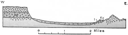
Alpine is in the broad valley or amphitheater of Alpine and Leoncito Creeks, about 4 miles wide, with alluvial floor, flanked on all sides by cliffs and peaks of volcanic rocks of the Tertiary succession. It is an exceptionally beautiful location, and the views in all directions are very attractive. Originally called Murphysville, Alpine came into existence with the railroad, Texas rangers being established there to protect the builders from the Indians, who hotly resented their presence. It is now an important commercial center for the Big Bend and a wide area of stock country to the north and west. The Sul Ross Teachers College, established in 1920, is built on the side of a hill east of the town. This hill is composed of lava (trachyte) of Tertiary age, but on its west slope 1-1/4 miles northeast of the station there is a small exposure of limestone of Comanche age dipping west, with relations shown in Figure 14. Near by, at the foot of the hill, is Kokernot Spring, or Charco de Alsate, on the Chihuahua trail from Fort Stockton to Presidio and the military road from Peña Colorada to Fort Davis. It was at this spring in the early days that a caravan of 40 freight wagons was surrounded by Apache Indians with the expectation that it would be easy prey. Fortunately one man was able to slip away and reach the United States Army post at Presidio, 100 miles distant, whence forces were sent to the rescue.
|
| FIGURE 14.—Section across the Alpine Basin just north of Alpine, Tex. l, Lava (Tertiary); ag, agglomerate; Kc, limestone (Comanche) |
A water hole which the railroad crosses on a bridge just west of Alpine is thought to be the place where Juan de Mendoza camped on January 4, 1684, on his notable exploration from the vicinity of El Paso across western Texas to Rio Concho. He was sent by Governor Cruzate, of the province of Nuevo Méjico, to explore the kingdom of the Tejas Indians. According to his very clear journal, he came there from Antelope Spring, south of Marfa, and on leaving it followed Leoncito Draw to Comanche Spring (now Fort Stockton) and the Concho River at the present San Angelo. (Turn to sheet 15.)
| <<< Previous | <<< Contents >>> | Next >>> |
bul/845/sec14.htm
Last Updated: 16-Apr-2007