
|
Geological Survey Bulletin 845
Guidebook of the Western United States: Part F. Southern Pacific Lines |
ITINERARY
|
|
SHEET No. 18 (click in image for an enlargement in a new window) |
NORTH LINE FROM EL PASO, TEX., TO MEZCAL, ARIZ.
From El Paso westward to Tucson the Southern Pacific Railroad has two lines—one going by way of Deming and Benson and the other (formerly the El Paso & Southwestern Railroad) by way of Columbus and Douglas. Leaving El Paso, the north line of the railroad follows the north bank of the Rio Grande for some distance, with Mexico in plain view on the opposite bank. (Turn to sheet 18.) In about 1 mile a large smelter (pl. 18, A) is passed, and in 2 miles a cement plant, near which are large quarries in limestone (of Comanche or Lower Cretaceous age) in a downfaulted block at the south end of the Franklin Mountains. It is the presence of this rock and a mass of intrusive porphyry associated with it that causes the constriction of the river valley at El Paso (Spanish, the pass). At the entrance of this pass the railroad crosses the river into New Mexico and skirts the north side of the Cerro de Muleros, a high ridge which lies mostly in Mexico. At one place the railroad is within a few yards of the Mexican boundary, and one of the monuments is plainly visible on a hill near by.95
95The monument marking the beginning of the boundary between New Mexico and Mexico is on the south bank of the Rio Grande a short distance south of the west end of the south-line railroad bridge across the river. It indicates the location of the point near by where the "deepest channel of the Rio Grande touches the parallel of 31° 47' north latitude," as prescribed in the terms of the Gadsden Purchase. (See p. 152.)
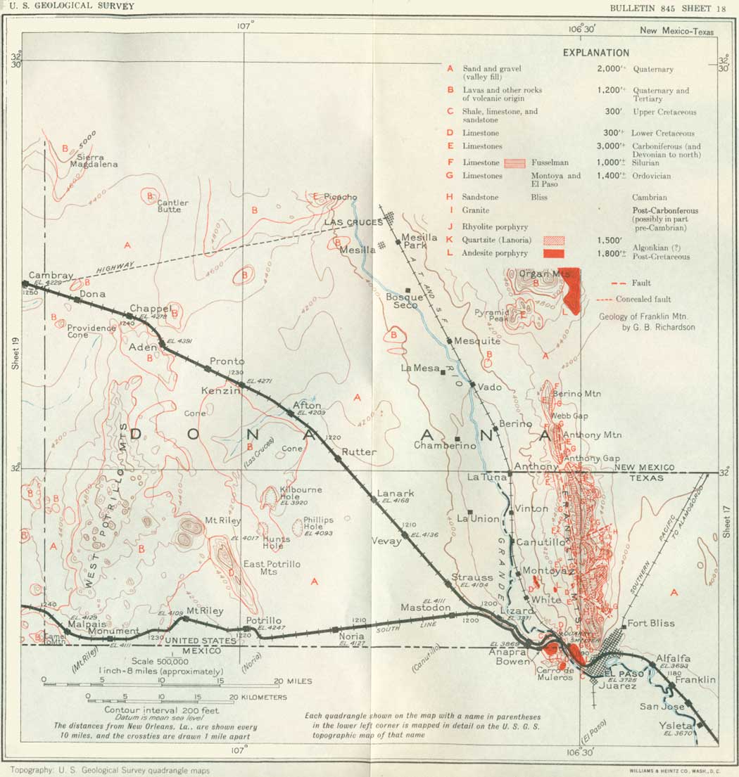
The Cerro de Muleros consists of a mass of limestone, shale, and sandstone of Cretaceous age penetrated and tilted by a large intrusive stock of porphyry.96 The lower or quarry limestone in this succession (of Fredericksburg, Lower Cretaceous age) is well exposed in the first railroad cut on the west side of the river. It is overlain by nodular and slabby limestones and shales containing large numbers of Washita fossils and grading up into a thick mass of dark shale in which there are deep cuts extending to and beyond Brickland siding. This shale is extensively worked for brick, hollow tile, etc., on the west bank of the river a short distance below the two railroad bridges.97 The relations are shown in Figure 27 (p. 134).
96In his description of the Cerro de Muleros, Böse gives the following section of the Comanche stratigraphy:
Feet 1. Limestone, hard, white and light gray, with Exogyra whitneyi 30-65 2. Marl, yellow, with Exogyra whitneyi and Hemiaster calvini 30-65 3. Sandstone, red-brown, thick bedded, with Exogyra whitneyi 65-320 4. Marl, brown, shaly; sandstone and limestone with Alectryonia quadriplicata 30-65 5. Marl, sandy, with shales and beds of limestone with Pervinquieria trinodosa 100-165 6. Shale, marl, and limestone, Pervinquieria nodosa 100-165 7. Limestone, sandy, thick bedded, calcareous gray sandstone, yellow and brown marl, and black shale with Oxytropidoceras cf. O. belknapi 30 8. Marl, brown, with beds of limestone and limy sandstone; Oxytropidoceras bravoense 30-65 9. Limestone, hard, thin bedded, gray, with Turritella vibrayeana 65-85
Böse suggests that No. 3 represents the Del Rio of Texas, No. 4 the Weno, No. 5 the Fort Worth and Denton, No. 6 the Kiamichi, and Nos. 7, 8, and 9 the upper Fredericksburg.
97In the upper part of the shale are sandy layers containing "Nodosaria" and other fossils indicative of the Del Rio horizon of the upper part of the Washita group (Comanche, Lower Cretaceous age). The shale is overlain by brown sandstone (possibly equivalent to Eagle Ford or the basal formation of the Upper Cretaceous), which is well exposed in a cut about 1 mile beyond the bridge, and this in turn is overlain by massive white limestone, also of Upper Cretaceous age, which is conspicuous near the tracks at intervals in the next half mile west. It contains numerous large shells of a species of Exogyra, a massive oyster with oddly curved beak, the species present here being peculiar to the later part of the Cretaceous period. In this area the railroad traverses a shallow syncline or basin, in which the sandstone underlying this limestone rises in the ridge to the west. Along the north line of the railroad, however, the relations are obscured in large part by the margin of the high-level deposits of the Rio Grande Valley, here consisting mostly of boulders of porphyry from the near-by Cerro de Muleros.
|
| FIGURE 27.—Section southwest from cement quarry 2 miles west of El Peso, Tex. ls, Limestone, and ss, sandstone, of Upper Cretaceous age; Kdr, Del Rio horizon, sh, dark shale; Kf, Fredericksburg group; Tp, intrusive porphyry. |
|
Anapra. Elevation 3,869 feet. Population 27.* New Orleans 1,195 miles. Strauss. Elevation 4,104 feet. Population 32.* New Orleans 1,204 miles. |
Just beyond Anapra siding, where the north and south lines are close together and joined by switches to be used in case of necessity, the railroad grade ascends the terrace of valley fill, the edge of which margins the Rio Grande Valley in a long line of steep slopes. The top is attained near Strauss siding. Along the upgrade are many fine exposures of the gravel and sand of which the terrace is composed. This material was deposited by the Rio Grande at an earlier stage of its history, when it flowed west of the Cerro de Muleros and another high range to the south and emptied into the Guzman Basin in Chihuahua, Mexico. This was before its present course was developed through the "pass" at El Paso. Looking east from this grade, the traveler gets fine views of the long west slope of the Franklin Mountains, with its succession of westward-sloping beds of limestone. Farther north is Organ Mountain, which, like the Cerro de Muleros, consists mainly of a great mass of porphyry intruded into the sedimentary strata. The central part of this igneous mass presents a massive columnar structure with spires having the appearance of huge organ pipes. The limestone into which this porphyry has been intruded has been greatly mineralized in places, notably at the Stevenson mine, east of Las Cruces, which has been a producer of silver and other ores for many years. Various rare minerals occur at this place. Up the valley is seen the winding ribbon of the Rio Grande, bordered in large part by irrigated fields. About 40 miles north, near Las Cruces, is the Mesilla Valley (may-see'ya), where a large amount of land is under intensive irrigation, utilizing water conserved by the Elephant Butte Reservoir,98 115 miles above El Paso.
98According to the United States Bureau of Reclamation the Elephant Butte Dam is 1,162 feet long, 306 feet high, and 154 feet wide at the base and contains 618,850 cubic yards of masonry. The reservoir extends 41 miles up the valley with an average width of 1-3/4 miles and a capacity of 2,638,000 acre-feet. It holds the floods of the Rio Grande and conserves the water for use when needed for irrigation all along the valley in southern New Mexico, western Texas, and Mexico.
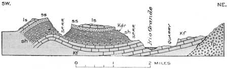
From Strauss siding the railroad goes northwest over the wide alluvial plain that extends entirely across the southwestern part of New Mexico. This plain is characterized by vast numbers of a species of yucca (pl. 20, A) with shaggy trunk and a cluster of white flowers, which finds the sandy soil favorable for its growth. This plant, locally known as soapweed or palmilla, yields a valuable fiber, and its roots, known as amole, are used as a substitute for soap. The datelike fruit is greatly relished by cattle. The northerly trend of the railroad in this area is taken to avoid the large rugged area of volcanic rocks of the West Potrillo Mountains and its extension to the north.
|
|
PLATE 20 A (top), "LILIES OF THE DESERT" Yucca in blossom in the
region west of Deming, N. Mex. B (bottom), OBTAINING A QUENCH OF WATER FROM THE BIZNAGA CACTUS. Sometimes a life saver in the deserts of the Southwest. |
|
Lanark. Elevation 4,168 feet. Population 40.* New Orleans 1,214 miles. |
The thick body of sand and gravel underlying the plain has been drilled for water at several points along the railroad. A boring at Lanark passes through 950 feet of beds, all supposed to be valley fill but possibly including some underlying Tertiary or Cretaceous strata. It found water which rises approximately to the level of the water in the Rio Grande Valley, 15 miles east. A boring at Kenzin, several miles beyond Lanark, passed through 550 feet of clay and sand with water in its lower part and continued through rock 527 feet farther.
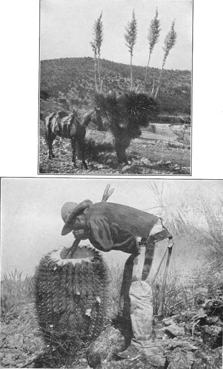
Beyond Rutter siding great lava fields are in sight to the southwest, and near Afton and Kenzin sidings the tracks skirt the edge of a fresh recent-looking lava flow (pl. 19, A), which came from two conical craters plainly visible to the south and southwest.
|
|
PLATE 19 A (top), TYPICAL EDGE OF A RECENT LAVA
FLOW IN SOUTHWESTERN NEW MEXICO. The ropy rounded surfaces and the broken
variety at the left are characteristic. (Hill.) B (bottom), RESTORATION OF GIANT SLOTH. From remains in Afton Crater, N. Mex. |
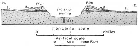
Eight miles southwest of Rutter siding are two large "holes" in the wide terrace plain which have been a source of much wonderment for many years. They were originally called Los Corrales de Piedra (rock corrals). The more northerly, Kilbourne Hole, shown in Plate 18, B, is 300 feet deep and is encircled by a rim of loose material 50 to 150 feet high, so that at many places it has a total depth of 450 feet, with a maximum of 463 feet. The diameter is nearly 2 miles. Hunts Hole, 2 miles south, is closely similar but smaller and has a rim of less height. A third one, Phillips Hole, to the southeast, is only about 50 feet deep and has no rim. The material in the wall of Kilbourne Hole (see fig. 28) is stratified sand similar to that which underlies the wide surrounding plain, capped by a 15-foot layer of lava, which thins out toward the southeast. The encircling rim is composed mostly of soft sandstone, strongly cross-bedded and including some cinders, fragments of pumice, and many angular blocks of lava. A very remarkable fact is that much of the cross-bedding slopes toward the hole. It is believed that these two holes were caused by a volcanic explosion probably with outburst of water. Steam doubtless accumulated in sand under the lava sheet until the pressure was sufficient to cause the explosion.
|
| FIGURE 28.—Cross section of Kilbourne Hole, 8 miles west of Lanark, N. Mex. By W. T. Lee. l, Lava; d, ejected material; Qss, sand |
In the sand penetrated by a 179-foot boring in the Kilbourne Hole part of the jaw of a Pleistocene horse was found at a depth of 70 feet, possibly in material that had caved from the sides of the hole. At the bottom of the boring a large amount of warm sulphur water was found.
Through Kenzin, Pronto, Aden, Chappel, and Dona sidings lava fields are in sight in every direction, especially on the south side of the railroad; most of them are recent outflows of scoriaceous basalt, but some are rhyolite of Tertiary age.99
99Along or near the railroad in many parts of southwestern New Mexico there are thick accumulations of volcanic rocks which, like those in the Davis Mountains and other parts of western Texas, are the product of eruptions that continued for a large part of Tertiary time. They consist of alternating lava flows of various kinds, mainly of the varieties known as rhyolite, andesite, and latite, which differ in character and order from place to place and are locally separated by thick beds of light-colored tuff and volcanic ash. These lavas and beds of fragmental materials occur in sheets of varying thickness; some of them are several hundred feet thick and of wide extent. They are much older than the recent basalt flows that occur in some of the valleys. Undoubtedly these older lavas were originally much more extensive and continuous than at present, for they have been uplifted, tilted, and in large part removed or cut back by erosion. They were erupted from cracks or craters, some of which are still recognizable by their character or configuration. The tuff is fine grained, is mostly of light color, and consists mainly of ash and small grains of pumice. It was blown out of vents by steam and deposited by wind or water in great sheets over the lava flows or other surfaces; in most places it was covered by later lava flows, the eruptions generally consisting of alternations of lava outflows and ejections of fragmental materials. There were also mud flows, consisting of material similar to the tuff and ash, mixed with water, which poured out of craters or vents and spread over the surface in plastic condition, in places to a thickness of 50 feet or more. (See p. 164.)
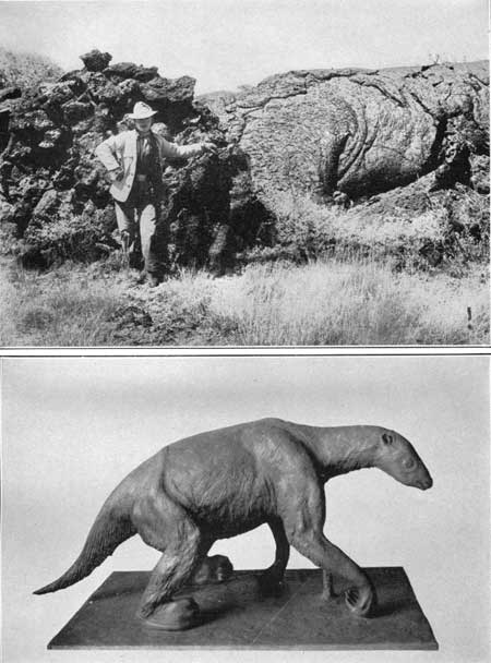
Aden Crater, 4 miles south of Pronto siding and 7-1/2 miles southeast of Aden siding, is a cone of lava undoubtedly marking the vent from which came one of the large recent lava flows skirted by the railroad in this vicinity. In its top is a deep blowhole or steam vent in the lava, in which many animal skeletons have been found, including coyotes, bobcats, and other animals of the present fauna, and a remarkable ground sloth which Lull1 has identified as Nothrotherium shastense. The remains were partly buried in bat guano in a sloping chamber about 100 feet below the surface. The bones of the sloth were held by the original ligaments and tendons, and some of the periosteum, patches of skin, muscle fibers, and claws remain. Most of the hide had been devoured by fellow victims, whose teeth marks are visible on the remaining fragments. The sloth and other animals had evidently fallen into this hole, which is a natural trap in the crater rim. The time was many thousands of years ago, for the sloth is of a species found also in the Rancho la Brea asphalt in Los Angeles, where it occurs with bones of middle Pleistocene age. (See pl. 19, B.)
1Lull, R. S., A remarkable ground sloth: Yale Univ. Peabody Mus. Mem., vol. 3, pt. 2, 1929.
Just south of Aden is a prominent knob of rhyolite of the older volcanic series with a basalt flow at its foot, and 3 miles west are other knobs of rhyolite tuff capped by basalt of the older succession. The volcanic area here extends so far north as to cause considerable northerly deflection of the railroad to reach a long tangent that passes through Chappel and extends beyond Carne. At Chappel the lava fields are left behind, but detached igneous masses are in sight not far to the south and north. Two miles south of Dona siding is the very prominent Providence Cone, rising nearly 300 feet above the surrounding desert plain. Apparently it was the orifice of an old volcano, but any flow of which it may have been the source has either been removed or lies beneath the valley fill. Far to the west from this place extends the level-floored Mimbres Valley (mim'brace), which merges into the Lake Guzman Desert, Mexico. This extensive basin has no surface outlet to the Rio Grande.
|
Cambray. Elevation 4,229 feet. Population 40.* New Orleans 1,250 miles. |
Near Cambray, the highway crosses the railroad, and after following the track for some distance, goes due west to Deming. It comes from El Paso by way of Las Cruces, passing through a country better suited for tourists than the sandy and desolate region traversed by the railroad. The old Butterfield stage route to California came through Mesilla, just south of Las Cruces, but crossed the desert in a course north of the present highway; it passed through a gap just south of Goodsight Peak and entered Cooks Peak Range in its southern extension, where old Fort Cummings was located adjacent to an excellent spring. (Turn to sheet 19.)
| <<< Previous | <<< Contents >>> | Next >>> |
bul/845/sec18.htm
Last Updated: 16-Apr-2007