
|
Geological Survey Bulletin 845
Guidebook of the Western United States: Part F. Southern Pacific Lines |
ITINERARY
|
|
SHEET No. 19 (click in image for an enlargement in a new window) |
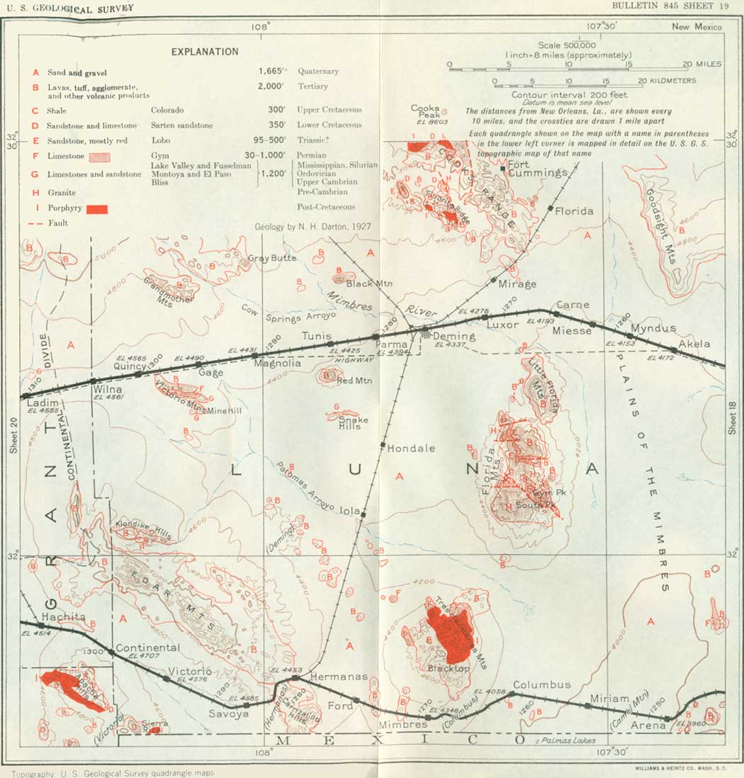
North of Cambray are the prominent Goodsight Mountains, which consist of a thick sheet of basalt capping a mass of agglomerate and tuff; the basalt dips gently to the east, as shown in Figure 29, but rises again in the mountains farther east.2
2The agglomerate in the east slope is a very massive rock and consists mostly of large and angular fragments of andesite in a more or less crystalline matrix. This rock appears again in many other parts of the region and is the product of a widespread eruption of late Cretaceous or early Tertiary age. It is overlain unconformably by gray conglomerate and 40 feet of soft gray sandstone, both consisting largely of volcanic materials and probably of Pleistocene age. The basalt is in three sheets, representing three effusions of lava. Much of it is vesicular or full of small holes due to steam in the lava when it was poured out. Evidently the agglomerate was tilted and planed off by erosion prior to the deposition of the overlying beds.
|
| FIGURE 29.—Section through Goodsight Peak, 15 miles northwest of Cambray, N. Mex. Tb, lava (basalt); Tss, gray sandstone; Tcg, conglomerate; Tag, agglomerate. |
The southern part of New Mexico is underlain by an extensive series of formations representing various parts of geologic time from pre-Cambrian to Recent. Most of them are also present in western Texas, as described in preceding pages. Those that are exposed near Deming and westward near the Southern Pacific Railroad are listed in the following table:
Geologic formations of southwestern New Mexico
| Age | Group and formation | Character and general relations | Thickness (feet) |
| Recent. | Alluvium. | Sand, gravel, and silt of river bottom, desert floors, and fans. | 0-1,000 |
| Unconformity | |||
| Pleistocene and Tertiary. | Volcanic rocks and associated deposits. | Lavas, ash, tuff, agglomerate, conglomerate, and sandstone. | 700-1,400 |
| Unconformity | |||
| Upper Cretaceous. | Colorado shale. | Dark shale. | (?) |
| Unconformity | |||
| Lower Cretaceous (Comanche). | Sarten sandstone. | Gray sandstone. | 450 |
| Limestone of Comanche age. | Limestone. | ||
| Unconformity | |||
| Triassic? | Lobo formation. | Shale, conglomerate, and sandstone, partly red. | 0-350 |
| Unconformity | |||
| Permian. | Gym limestone. | Limestone, massive and slabby. | 30-1,000 |
| Unconformity | |||
| Pennsylvanian. | Magdalena formation. | Limestone, with some shale. | 0-40 |
| Unconformity | |||
| Mississippian. | Lake Valley limestone. | Limestone. | 0-700 |
| Devonian. | Percha shale. | Black shale. | 0-175 |
| Silurian. | Fusselman limestone. | Limestone, massive. | 100-300 |
| Unconformity | |||
| Ordovician. | Montoya limestone. | Limestone with cherty member above, sandy below. | 0-300 |
| Unconformity | |||
| El Paso limestone. | Limestone, slabby; weathers light gray. | 500-800 | |
| Cambrian. | Bliss sandstone. | Sandstone, massive to slabby, glauconitic. | 30-200 |
| Unconformity | |||
| Pre-Cambrian. | Granite and schist. | ||
|
Deming. Elevation 4,337 feet. Population 3,377. New Orleans 1,276 miles. |
Deming is a long-established commercial center, railroad junction, and headquarters for mining and irrigation interests. Here the Atchison, Topeka & Santa Fe Railway from Albuquerque passes on the way to Silver City, and there is a branch railroad connecting with the south line of the Southern Pacific at Hermanas. There is now but little mining in the immediate vicinity, but ores of various kinds have been produced in the adjoining mountains, notably fluorite (calcium fluoride) from mines 10 miles northeast, and manganese ore from a mine in the north end of the Little Florida Mountains, 12 miles southeast. There are extensive mines at Silver City and near Santa Rita, about 50 miles northwest of Deming.
However, the underground water in the sand and gravel about Deming and southward is the most important economic resource in the region, and it is utilized extensively in irrigation.3 It lies from 25 to 150 feet below the surface. A large area is underlain by the water-bearing beds, but the largest volume at moderate depth is found about Deming and in the lower part of the wide bolson extending southward from that place along the west side of the Florida Mountains (flo-ree'dah). It is believed that the water is an extension of the underflow from the Mimbres River with additions from confluent streams, and there is some increment from the local rainfall, which amounts to about 10 inches a year. Although most of the rain water evaporates, a certain proportion passes underground where the soil is porous. There is, however, a return of part of this water to the surface by capillary action, which is strong in arid regions. The volume of water stored in the valley fill is great, but it is well known that such a supply can be depleted if it is drawn upon more heavily than it can be replenished. To ascertain these conditions a careful investigation was made by the United States Geological Survey,4 cooperating with the State of New Mexico, to ascertain the amount of water available. It was estimated that the average annual increment of the ground water during 20 years was from 10,000 to 11,000 acre-feet, with a high rate in wet seasons, and therefore that this should be the limit of its utilization. The rate of movement down the valley is mostly from 2 to 3 feet a day. Heavy pumping reduces the level of the underground water table.
3Described by N. H. Darton in U.S. Geol. Survey Bull. 618 and Water-Supply Paper 345—C.
4Results given in U. S. Geol. Survey Water-Supply Paper 637—B, by W. N. White.
Irrigation by well water began in 1908, and in 1914 nearly 200 pumping plants had been installed or were under erection. As most of the operators were inexperienced in agriculture many of the projects were not profitable, and in 1919 only 25 pumps were in operation. In 1930 there had been considerable revival of the industry, and 116 pumps were supplying water for irrigation and other uses, and about 6,000 acres were under cultivation, mostly with very satisfactory returns. The water is generally less than 50 feet below the surface and is pumped with small gasoline engines, with a yield of 200 to 1,000 gallons a minute. Various crops are raised, including a large acreage of beans and considerable alfalfa. The amount of water necessary varies with the soil and crop, but 2 to 2-1/2 acre-feet to the acre is used. A well producing 500 gallons a minute can irrigate 25 acres in about three days, but this must be repeated several times during the growing season.
The wide desert about Deming, known as the Florida Plains, is a part of the valley of the Mimbres River (Spanish, mimbres, water willow), past and present. It is heavily covered by valley fill, the bottom of which appears not to have been reached by borings 710, 980, and 1,665 feet deep in Deming and vicinity. Out of the level surface of this plain or valley rise several high mountains and ridges, such as the Florida Mountains; the Tres Hermanas Mountains, far to the south; the Victorio Mountains, to the west; the Goodsight Mountains, to the east; and Cooks Range with its prominent culminating Cooks Peak, to the north. There are also many isolated ridges and buttes that rise abruptly from the desert plain. One of these, Black Mountain, a prominent isolated mesa 10 miles to the northwest, is capped by an eastward-dipping sheet of basalt. Another conspicuous feature is Red Mountain, 10 miles southwest of Deming, which consists of a large mass of rhyolite.
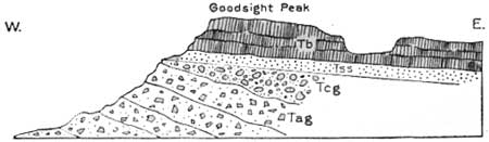
The Florida Mountains, southeast of Deming, form the most striking feature of the landscape, with exceedingly high rough crags all over their higher summits. At one point there is a jagged hole through the crest known as Arco del Diablo (bridge of the devil), 85 feet high by 250 feet long, which is visible from Cambray to Luxor. The northern half of the range, like the outlying little Florida Mountains, consists of agglomerate and other igneous rocks; the southern half is pre-Cambrian granite overlain by sandstones and limestones of Cambrian to Permian age. The rocks are tilted and traversed by several faults of moderate amount. The principal relations are shown in the sections in Figure 30.5
5In general the range is a tilted block of pre-Cambrian granite capped by sedimentary strata in an eastward-dipping monocline that is possibly the eastern limb of an anticline whose axis lies under the bolson on the west, or the uplift may be bounded on that side by a fault. At Capitol Dome, at the north end of the range, the Paleozoic rocks and agglomerate deposits all dip to the east-northeast, and the underlying granite is exposed at the foot of the western slope. This easterly dip, with repetition of the limestones by faulting, is exhibited again farther south in the center of the range, where there is a profound fault that trends northeast with an upthrow that lifts the granite 2,000 feet or more in the south end of the range. Gym Peak consists of Permian limestone dipping east; on the west side of the peak this limestone extends westward over the uneven edges of the underlying Fusselman (Silurian), Montoya (Ordovician), and El Paso (Ordovician) limestone for some distance. There may be an overthrust at this place. Possibly also Percha beds of Devonian age are buried here, for black shale appears along a cross fault southwest of Gym Peak. The Gym limestone is about 1,000 feet thick, but its upper surface is eroded.
The Lobo formation, which occurs in the northern part of the Florida Mountains, with a thickness of about 300 feet, consists largely of reddish and gray shale and gray to pinkish impure limestone, with coarse basal beds. Near Capitol Dome, a conspicuous peak on the north end of the mountains, this formation extends across a fault (shown in fig. 30, A) which lifts the granite about 1,000 feet to the level of the top of the El Paso limestone. The uplifted block was eroded to a plain before the deposition of the Lobo beds, and therefore their age is believed to be post-Paleozoic, probably Triassic.

FIGURE 30.—Sections across Florida Mountains, Luna County, N. Mex. A, Through Capitol Dome, near the north end; B, through Gym Peak. b, Bliss sandstone; e, El Paso limestone m, Montoya and Fusselman limestones; l, Lobo formation; g, Gym limestone; k, keratophyre dikes; Agr, granite; ag, volcanic agglomerate.
The ridge known as the Little Florida Mountains consists of a thick sheet of felsitic or vitreous rhyolite, included in a thick deposit of agglomerate apparently somewhat younger than the beds constituting the north end of the Florida Mountains. It is possible, however, that a fault may pass between the two ranges. The structure is shown in Figure 31, in which section A shows the relations that prevail along the greater part of the ridge and section B shows features of the faulted portion farther south. Manganese ore is mined in the north end of the range.
|
| FIGURE 31.—Sections across the Little Florida Mountains, N. Mex. A, Across center of range; B, 1-1/2 miles farther south. ag, Agglomerate; r, felsitic rhyolite; o, obsidian; k, keratophyre |
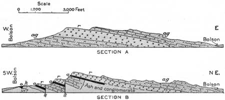
The conspicuous ridge a few miles north of Deming is Fluorite Ridge, an outlier of the south end of the Cooks Range. It consists of a thick central mass of porphyry so intruded as to cause an irregular dome-shaped uplift, elongated to the northwest and southeast. The strata on the south and east sides of the dome stand nearly vertical, but those on the north and west sides have more moderate dips. The plane of intrusion is low in the Paleozoic strata at the southeast end of the uplift, but it rises rapidly toward the north and west, finally reaching the base of the Sarten sandstone (Cretaceous). There are several faults at the south end of the ridge.6
6Red granite and diorite (pre-Cambrian) are exposed in the lower Southern slopes and also a breccia of mica schist fragments. The Bliss sandstone is overlain by a regular succession of strata to and including the lower portion of the Lake Valley limestone. Some of the beds are greatly squeezed, notably the El Paso limestone, which presents a thickness of only 400 feet. Some huge masses of white siliceous rock at the east end of the range have undoubtedly replaced limestone, probably of both Lake Valley and Montoya age. A profound fault that extends along the east side of the ridge appears to lift porphyry, although it is possible that this igneous rock was intruded after the faulting, and there is some suggestion that it is younger than the agglomerate which is exposed in the slopes on the east side of the ridge. The west end of Fluorite Ridge consists largely of Sarten sandstone penetrated by porphyry and overlain by Tertiary agglomerate. A small exposure of granite in the locality indicates either faulting or overlap, for in places the Sarten sandstone lies directly on granite. Goat Ridge, a short distance to the west, is an elongated dome with axis trending northwest that exposes Sarten sandstone. The underlying Lobo formation (Triassic?) is revealed in part of the area, and granite appears on the northwestern slope of the ridge. The Pony Hills, a small group of knobs just north of Fluorite Ridge, consist of irregular outcrops of granite and Sarten sandstone in juxtaposition, owing either to overlap or to faulting.
In the southeast end of Fluorite Ridge a large amount of the mineral fluorite has been mined. It consists of calcium fluoride and is of bright-green color, crystalline structure, and glassy aspect. It is used extensively in steel making. The mineral occurs in several steeply dipping veins, mostly in the porphyry; these varied from a few inches to 12 feet or more in thickness with a general range in the workings from 2 to 5 feet. Much of the fluorite was more than 90 per cent pure. For several years this material found a ready market at Pueblo, Colo., and other places, and the annual production averaged about 5,000 tons, but cheaper sources of supply were found and the workings are now abandoned.7
7Darton, N. H., and Burchard, E. F., Fluorspar near Deming, N. Mex.: U. S. Geol. Survey Bull. 570, pp. 533-545. 1911.
|
| FIGURE 32—Section across Fluorite Ridge, N. Mex. Tag, Agglomerate; Ks, Sarten sandstone; l, Lobo formation; Clv, Lake Valley limestone; Om, Montoya limestone overlain in part by limestone of undetermined age; Oe, El Paso limestone €b, Bliss sandstone, gr, granite and diorite; p, porphyry; b, diabase dike |
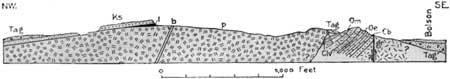
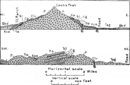
The Cooks Range, lying north of Fluorite Ridge and a very conspicuous feature from Deming, is an irregular dome due to a great central intrusion of porphyry which brings into view a floor of pre-Cambrian granite and the succession of Bliss sandstone, El Paso, Montoya, and Fusselman limestones, Percha shale, Lake Valley, and Gym limestones, limestone of the Magdalena group, Lobo formation, Sarten sandstone, and Colorado shale. The southern slope consists of agglomerate, Sarten sandstone, and Colorado shale. Some relations to the central and southern parts of the range are shown in Figure 33.
|
| FIGURE 33.—Sections across Cooks Range, N. Mex. Upper section, through Cooks Peak; lower, about 3 miles south of Cooks Peak. Base of sections, 5,000 feet above sea level. P, Porphyry; Tag, agglomerate; Qbd, valley fill; Kco, Colorado shale; Ks, 5arten sandstone; TRl, Lobo formation; Cg, Gym limestone and Magdalena formation; Clv, Lake valley limestone; Dp, Percha shale; SOf, Fusselman and Montoya limestones on El Paso limestone |
Cooks Peak consists of a large laccolithic mass of granodiorite porphyry which was intruded in a molten condition into the Lake Valley limestone and adjoining strata. Several other large porphyry intrusions occur southwest and south of the high central area.
On the west slope of the range northwest of Cooks Peak and in the slopes south of that peak the Sarten sandstone is exposed, overlain by shale of Colorado age (Upper Cretaceous). It contains fossils of Comanche age (Lower Cretaceous). This sandstone constitutes the prominent dip slope 2 miles south of Cooks Peak, which becomes Sarten Ridge to the south, where the Sarten sandstone is underlain by the Lobo formation, the Gym and Lake Valley limestones,8 and a small amount of Percha shale.
8The Lake Valley limestone (early Mississippian), which crops out in several places in the Cooks Range, is overlain by about 40 feet of dark-gray shale with limy layers of the Magdalena formation, and this in turn by Gym limestone, here only 20 to 30 feet thick, which is believed to be a representative of part of the Chupadera formation of New Mexico. In this region it is overlain by the Lobo formation, about 100 feet thick, consisting principally of reddish or brown sandstone or shale. The Lobo beds are also exposed on Goat Ridge and in the deep hollow near the south end of Sarten Ridge.
From Deming the railroad line goes slightly south of west on a tangent 37 miles long over a great desert plain, with a rise of only 250 feet in 33 miles to the Continental Divide.
At Tunis siding Black Mountain seems near on the north, showing in cross section its eastward-dipping cap of black basalt about 250 feet thick, lying on volcanic ash and sand of which 500 feet is exposed, cut by rhyolite. Still nearer, to the south, is the craggy butte known as Red Mountain, so named from the pinkish tint which it shows in some lights. It consists of nearly white felsitic rhyolite, apparently lying on agglomerate. Probably this igneous mass was extruded in a highly viscous condition, so that it piled up thickly without extending far beyond its present area. It is regarded as of Tertiary age.
The Snake Hills, a group of low mounds in the plain 3 miles south of Red Mountain, consist of the upper member of the El Paso limestone and the lower member of the Montoya limestone.
|
Gage. Elevation 4,590 feet. Population 20.* New Orleans 1,296 miles. |
North of Gage are some conspicuous rounded and pointed buttes known as the Grandmother Mountains, composed of felsitic rhyolite similar to the rock of Red Mountain and doubtless extruded at the same time. Other buttes farther north include Cow Cone, which also is part of a large mass of felsitic rhyolite. In the distance to the north are the mountains in which lies Silver City. South of Gage are the Victorio Mountains, which present many features of geologic interest. The main ridge consists of a sheet of hornblende andesite about 200 feet thick underlain in part by a thin sheet of rhyolite. It dips 20°-25° NNE. In the hills just south of this ridge there are, in succession, the El Paso, Montoya, Fusselman, and Gym limestones.9 Devonian, Mississippian, and Pennsylvanian time apparently is not represented. Figure 34 shows the principal features in both parts of the uplift.
9The Gym limestone, about 300 feet thick, crops out in a zone about 2,000 feet wide marked by knobs on the south side of the range. It appears to lie on the Montoya limestone, but possibly there is a separating fault. It contains several distinctive fossils. The Gym is overlain unconformably by 700 feet of shale and sandstone, mostly reddish, which resembles the Lobo formation (Triassic?) but may be much younger. Dark purplish-brown fine-grained massive shale and sandstone predominate, but several beds of coarse conglomerate are included which contain boulders of andesite and near the top some greenish quartzite carrying pebbles of fossiliferous Paleozoic limestone. There are various unconformities in the succession, but all the strata have practically the same attitude. There are several faults and some obvious overlaps. The Fusselman limestone carries an interesting fauna of Niagaran corals and lies on cherty beds of Montoya limestone with Richmond fossils. The Montoya includes a prominent sandstone member. There are several intruded dikes, mostly of porphyry. A small amount of mineralization has occurred along the fault in the west side of Mine Hill, but the mining operations on this zone apparently did not yield a return sufficiently satisfactory to warrant extensive development.
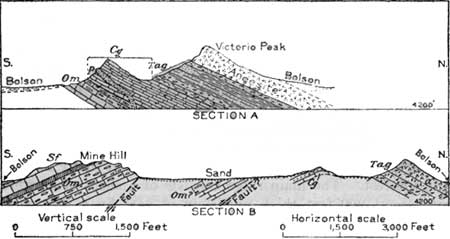
FIGURE 34.—Sections across Victorio Mountains, south of Gage, Luna County, N. Mex. a, Andesite; Tag, agglomerate, shale, and sandstone; Cg, Gym limestone (Permian); Sf, Fusselman limestone; Om, Montoya limestone; p, porphyry dike
About halfway between Wilna and Ladim sidings the railroad crosses the Continental Divide at an elevation of 4,587-1/2 feet. A sign marks the place, which is on the broad bolson or valley fill of unknown thickness, far from the rock ledges in the hills to north and south. About a mile north of Ladim siding there is a low butte consisting of limestone with much chert which is probably of Ordovician age (Montoya) or possibly of Lower Cretaceous age. (Turn to sheet 20.) To the west is a gentle down grade into Lordsburg, but with the course changing to northwest to pass the north end of Pyramid Mountain. At Separ siding are wells over 600 feet deep from which about 40,000 gallons of water a day is pumped for use by the locomotives. It is contained in gravel and sand in the thick deposit of alluvial fill which underlies this valley. About 12 miles north of Separ are the foothills of the Burro Mountains, consisting of granite overlain to the east by volcanic rocks forming high conical buttes. Considerable turquoise has been obtained from these mountains, mainly by the Indians. This beautiful gem mineral was mined by American aborigines at an early time, for beads and pendants of it are found in ruins at Chaco Canyon, N. Mex., the earliest of which (according to the annual growth rings in some of the timbers) probably date back to the time of Christ, and turquoise is mentioned in many of the old myths of the pueblo people of the Southwest. In 1539 Marcos de Niza met Sonoran Indians who worked in turquoise mines in New Mexico, probably those at Los Cerrillos, which for centuries were the most productive source of the mineral in this country. The very old mines in the Burro Mountains were relocated years ago and worked for some time.
| <<< Previous | <<< Contents >>> | Next >>> |
bul/845/sec19.htm
Last Updated: 16-Apr-2007