
|
Geological Survey Bulletin 845
Guidebook of the Western United States: Part F. Southern Pacific Lines |
ITINERARY
|
|
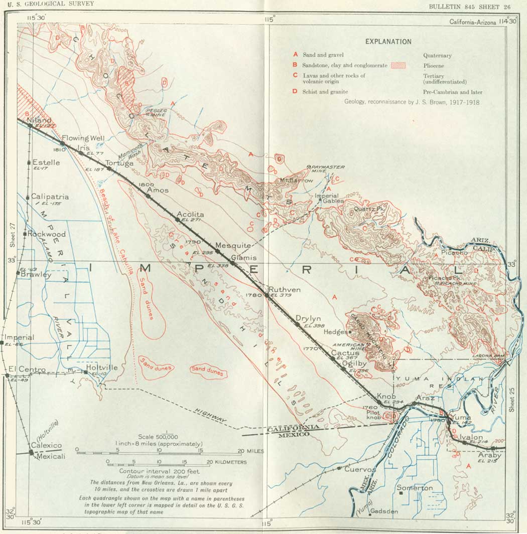
SHEET No. 26 (click in image for an enlargement in a new window) |
|
Yuma. Elevation 142 feet. Population 4,892. New Orleans 1,750 miles. |
Yuma, one of the oldest towns in the Southwest, long the commercial center for a large surrounding area, and now the headquarters of a productive irrigation project, is situated on the east bank of the Colorado River just below the mouth of the Gila River. The Gila here is in a broad alluvial terraced valley, from which a few low granite knobs protrude, and this rock is reported in deep borings. The bridge abutment at Yuma is on very coarse granite conglomerate of Tertiary age, which also forms the knoll on which the ruins of the old Territorial prison remain. Its components probably were derived from granite knobs in the center of town and to the southeast. This same formation underlies the basalt that caps Black Mesa, west of Laguna Dam, on the Colorado River 10 miles above Yuma.
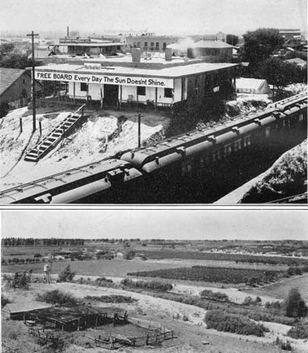
Yuma is famous for its high summer temperature and large percentage of sunshine, but with the low annual precipitation of 3.1 inches64 (40-year average), the humidity is so slight that during the greater part of the year the heat is not oppressive. Relying on the almost perpetual sunshine, a hotel near the railroad station formerly bore the striking sign "Free board every day the sun doesn't shine" (pl. 34, A).
64The precipitation varies greatly from year to year, having been 11.4 inches in 1905 and 0.6 inch in 1899. The greatest amount of rain usually falls in midsummer. Sandstorms occur occasionally, but their importance or danger is greatly exaggerated. The average temperature for 29 years is 72°, with extreme ranges from 20° to 117° in the bottom lands and 29° to 117° on the mesa.
|
|
PLATE 34.—A (top), PART OF YUMA, ARIZ. The income
of this hotel was rarely interrupted. B (bottom), IRRIGATED DISTRICT ON THE LOWER LANDS NEAR YUMA. |
The history of Yuma dates back to 1540, when Alarcón came up the Gulf of California and ascended the Colorado River to cooperate with the land expedition of Coronado. In 1700 Padre Kino came down the Gila River to its mouth, where he found, on the Arizona side, a large ranchería of Indians, which he named San Dionisio. The Yuma Indians gave a cordial reception to the first Spanish explorers and missionaries. The Jesuit missionary Jacobo Sedelmaier reached the Colorado River in 1744 and again in 1748. In 1779 Garcés established the Mision de la Purísima Concepción on the west bank of the river opposite the present town. About 53 families of colonists, laborers, and soldiers, appropriating the best lands, settled near by and also at another mission near Pilot Knob, about 8 miles down the river. The Indians occupied palisaded towns and raised melons, squashes, and grain. Although they had previously appeared most friendly and amenable, they were irritated by the failure of the Spanish authorities to fulfill promises, and in 1781 they started an uprising in which Padre Garcés and three other priests and most of their white men associates, to the number of about 46, were slaughtered, including the visiting Lieutenant Governor of Baja California and a dozen of his soldiers who were camped on the Arizona side of the river. The women and children were enslaved. After this one serious outbreak the Yuma Indians did not prove troublesome to the whites. Originally a powerful race, they themselves suffered much in wars with other tribes and in 1857 were almost annihilated by the Pima Indians.
The first military post, then called Camp Calhoun, was established on the west side of the river in 1849 by United States Dragoons, who escorted Whipple's boundary-survey party. In this year also a boat which came down the Gila River from the Pima region was pressed into service as a ferry across the Colorado River, and on this ferry during the gold rush many thousands crossed to California. The fare was $2 for man or animal. Fort Yuma was established on the west side of the river in 1851, when Camp Independence, as it was then called, was moved to the site of the old mission and renamed.
In 1861-62 the region was partly devastated by a flood. The settlement on the east bank of the river, called Colorado City, Arizona City, and finally Yuma, began to prosper in 1864, and in 1871 the county seat was moved there from La Paz, 75 miles up the river. The first steamboat to ascend the river was the Uncle Sam, in 1852, built at the head of the Gulf of California. In 1855 several steamboats were running on the river, and in 1857 Lieut. Joseph Ives started from the mouth of the Colorado in a 50-foot iron stern-wheel steamer (pl. 33, A) and ascended to the "head of navigation" through Black Canyon, the site of the reservoir to be impounded by the Boulder Dam. (See p. 241.) Freight boats came up the Colorado as late as 1895. The Southern Pacific Railroad reached Yuma from the west on September 29, 1877, and established its station on the east bank, south of the mouth of the Gila, where there had been a few houses since the time of the Gadsden Purchase, in 1854. That place remained the terminus until April 28, 1879, when the tracks were completed to Maricopa. In 1880 connection with the East was effected. Now Yuma is entirely on the Arizona side.
Yuma and its environs have been greatly benefited by the completion of the Yuma irrigation project of the United States Bureau of Reclamation. The water is diverted from the Colorado River at Laguna Dam, 10 miles northeast of Yuma on the California side, begun in 1902, one of the first results of the reclamation act. The dam is 4,780 feet long and raises the stream about 10 feet, creating a long, narrow lake that provides water for 100,000 acres of irrigable land lying partly in Arizona and partly in California. Part of the region is the alluvial flat along the river, including the Yuma Indian Reservation of 8,000 acres on the California side, and part is on the level "mesa" or terrace extending south from Yuma, onto which the water is raised by pumps operated by cheap electric power produced near by.
The mesa division comprises 45,000 acres lying about 80 feet above the valley, of which approximately 15 per cent is now being developed, with 1,400 acres under cultivation and 934 acres producing in 1930. The soil is very sandy, but its deficiency in organic matter is easily remedied by the use of fertilizer. The climate is frostless and well adapted to citrus and other semitropical fruits, which in 1930 yielded a return of $156,265, or nearly $167 an acre. (See pl. 34, B.) About two-thirds of the product was grapefruit, of which about 60,000 trees were bearing in 1930. It costs from $8,000 to $10,000 to develop a 10-acre unit. The yield of citrus fruits averages about $50 an acre after 4 years, $163 after 6 years, and $350 after 8 years. The value of all crops of the Yuma lowlands and mesa in 1928 was $5,105,132, or $113 an acre. The total cost of construction of the Yuma project has been more than $12,000,000, but this is being repaid to the Government by the owners of the land. It amounts to $55 to $90 an acre. (U. S. Bureau of Reclamation.)
An interesting engineering feature of this project is the siphon by which part of the water is carried under the Colorado River, an expedient necessitated by the difficulty of carrying a canal across the Gila River, which empties just above Yuma. The water is brought from the Laguna Dam by a canal along the west side of the river; the siphon is 1,000 feet long and 14 feet in diameter and passes 50 feet below the bed of the river. The inlet may be seen just north of the railroad bridge. The Colorado River carries a large amount of silt,65 but much of this is caught in a desilting basin at the Laguna so that it does not clog up canals farther down.
65According to investigations by the Bureau of Reclamation, in times of freshets the silt may be as much as 2 per cent, but the average amount is 0.7 per cent, or 30 times as much as is carried by the Ohio River.
The limit of area of farm units is 40 acres. The duty of water averages 3 acre-feet an acre at the farm, and the irrigation season lasts throughout the year. On the rich alluvial bottom lands a great variety of crops is grown, but the principal ones are cotton, alfalfa, millo maize, kafir corn, feterita, wheat, and barley. A yield of 2 bales of cotton to the acre is not uncommon, and alfalfa seed is a profitable product which yields as much as half a ton to the acre from two cuttings. For hay, however, the alfalfa may be cut six or more times a year. There is a large acreage of pecan groves, some of the older trees producing as high as 180 pounds of nuts. The bottom lands are protected from overflow by levees and drained to prevent accumulation of mineral matter by evaporation.
From Yuma a trolley line runs south down the Colorado Valley as far as Gadsden, passing west of the irrigation settlement of Somerton (population 891).
In the valley filling along the Colorado River above the Laguna Dam there is considerable fossil wood, which is often brought into Yuma. The larger logs are a few feet long and less than a foot in diameter. Many of them show grain and ring structure in a very striking manner. They are said to be closely related to some of the present-day desert hardwoods.
| <<< Previous | <<< Contents >>> | Next >>> |
bul/845/sec26.htm
Last Updated: 16-Apr-2007