
|
Geological Survey Bulletin 845
Guidebook of the Western United States: Part F. Southern Pacific Lines |
ITINERARY
|
|
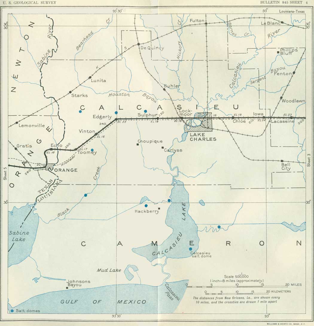
SHEET No. 4 (click in image for an enlargement in a new window) |
Just beyond Welsh the railroad crosses the east branch of Bayou Lacassine, the water of which is used to some extent for rice irrigation; the west branch of this stream is crossed just east of Lacassine siding. A short distance west of that siding there is a small clump of pines south of the railroad, a sporadic outlier of the great pine forest that covers a large part of western Louisiana and eastern Texas. Not far beyond this place the Missouri Pacific Railroad is crossed.
In this region "pimple mounds" appear in the prairies, and they become more numerous toward Lake Charles and beyond, though somewhat scattered. Most of them are less than 3 feet high and approximately circular. A few of the larger well-formed mounds are very conspicuous and reach 75 to 100 feet in diameter. Many of them have been more or less obliterated by cultivation, and some have been cut by drainage ditches and road grading. They occur at intervals far into eastern Texas and over a wide area in the region north. Their origin is unknown, although many theories have been advanced to account for them.
|
Lake Charles. Elevation 16 feet. Population 15,791. New Orleans 220 miles. |
The city of Lake Charles is attractively located on the wooded shores of Lake Charles, a broad expansion of the Calcasieu River, one of the principal streams of southwestern Louisiana (formerly called the Rio Hondo). The name Calcasieu is derived from that of an Indian tribe which once occupied the region and is now represented by a few descendants living in the northern part of Calcasieu Parish. This river, which is crossed west of the town, was the resort of slavers in the early days when the region west to the Sabine River was neutral territory between Mexico and the United States. The name of the city is taken from the lake, which was named for Joseph Charles, an old settler. This city is the farthest inland of the Gulf ports, being 75 miles from the coast, with which it is connected by a 30-foot channel dredged though the river, Calcasieu Lake, and Calcasieu Pass, at the joint expense of the parish and the United States. This channel has no tide and no locks. The harbor basin has accommodations for all classes of ocean vessels, by which it ships more rice than any other port in this country. One of the three large mills in the city manufactures cellulose from rice hulls and is said to be the only plant of its kind in the world. Considerable cotton is raised near by, and lumbering is an important industry.
In the marshlands of Cameron Parish, south of Lake Charles, are two isolated domes, the Hackberry and the East Hackberry, which produce a large amount of petroleum. The latter was discovered in 1926 by means of seismograph survey in a region where there are no surface indications of geologic structure. The oil is derived largely from sand of Miocene age20 at a depth of 3,900 feet, but oil is also produced from sand over the "cap rock," which lies about 2,955 feet below the surface. One 6,995-foot hole is in shale of supposed Jackson (Eocene) age. From 1927 to the end of 1930 a little more than 4,000,000 barrels of oil was produced from 50 wells in this district, according to the United States Bureau of Mines.
20The subsurface geology of this part of Louisiana as revealed by borings is as follows: Recent marsh deposits of much sand and clay, about 50 feet; sand and gravel of the Beaumont formation (350 feet) and Lissie formation (650 feet); a thick succession of blue sandy silt, blue and gray silty sand, clay, blue-green shale, and some clean sand, mostly fine grained, representing the Pliocene and Miocene, 5,000 feet or more; older Tertiary gray silty sand, sandy shale, and hard gray shale, 500 feet or more. These beds are underlain by heavy shale believed to be of Jackson age. (Bauernschmidt.) (See also table, p. 19.)
Lake Charies is about at the eastern margin of the great pine belt which extends westward to and beyond Beaumont, Tex., and far to the north; for much of the distance between these two places the railroad skirts its southern border. Originally there were large forests of fine timber in this region, but much of the pine has been cut.
In the great marshes between Calcasieu and Sabine Lakes, southwest of Lake Charles, is a muskrat "ranch," 29 miles long by 14 miles wide, comprising 170,000 acres and having 70 miles of canals. Here a large number of pelts of this animal are obtained every year. The region is also famous for hunting and fishing. Water hyacinths grow in picturesque abundance in its many ponds and bayous.
|
Sulphur. Elevation 19 feet. Population 1,888. New Orleans 230 miles. |
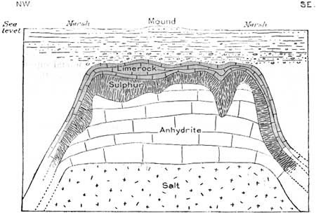
To most persons it may be surprising to learn that our largest supplies of sulphur have been found under the smooth, low prairies of southwestern Louisiana and eastern Texas. One mine that was a very large producer for many years was 2-1/2 miles northwest of Sulphur and only a short distance north of the Southern Pacific tracks. The total production here exceeded 10,000,000 tons and had a gross value of more than $150,000,000 (Kelly). The sulphur is now exhausted. The mineral occurred in the anhydrite cap of a circular, flat-topped salt dome of small extent, 75 acres in all, where it had accumulated through chemical reaction for a very long period. The relations are shown in Figure 2.21 The sulphur was discovered in a 1,230-foot boring for petroleum, of which a small surface seep had long been known, the black ooze being used by early settlers for axle grease. The first attempts at mining were made by a French company, which planned to use a huge iron caisson shipped in sections from France, but the enterprise failed after the expenditure of nearly a million dollars. One of the rings of this caisson still lies on the bank of the Calcasieu River, with a pine tree 2 feet in diameter growing through it. After several other vain attempts to mine the sulphur, the Frasch process22 was developed in 1903; by this process the sulphur was melted in place by steam, pumped to the surface in liquid form, and stored in great vats until needed. (See pl. 6, B.) In this way the sulphur accumulated in solid blocks 1,000 feet long, 500 feet wide, and 50 feet high, from which it was easily broken for shipment. Since 1919 the great deposits of sulphur at Gulf, New Gulf, and other places in Texas have become the chief source of our commercial supply, with reserves of many millions of tons. Recent drilling on the Sulphur dome has developed an oil field which in 1930 had a production of 1,351,195 barrels from 33 wells.23
21 The overlying material consists of about 250 feet of yellow and red clay alternating with sandy clay and sand (Beaumont clay) and gravel (Citronelle formation) to the cap rock. The sulphur is thought to have been derived from the reduction of the calcium sulphate of the anhydrite, an origin indicated by the fact that the volume of sulphur and limestone (calcium carbonate) was found to increase in proportion to the decrease in calcium sulphate.
22This ingenious method of obtaining sulphur from deep underground deposits was perfected by Hermann Frasch in 1891 after many years of experimentation. A hole is drilled deep into the deposit, which is mostly a mass of honeycombed limestone filled with sulphur. Into the hole three concentric pipes are placed with perforations at their ends; through the outside pipe superheated steam (300°) is supplied, which melts the sulphur. The central and somewhat longer pipe conveys hot compressed air, which so lightens the liquefied sulphur that it is forced to the surface by the combined air and steam and water pressure. The heat of the steam and water in the outer column and in jacketed pipes on the surface keeps the sulphur melted while it is conveyed to vats built up with wooden walls to the requisite height.
23South Louisiana Oil Scouts Assoc. Bull. 1, 1930.
|
| FIGURE 2.—Section across dome near sulphur, La. After Kelly |
There are extensive rice fields interspersed with swamps and forests about Sulphur and in the region west, notably about Edgerly and Vinton.
|
Edgerly. Elevation 23 feet. Population 150. New Orleans 238 miles. |
Just south of Edgerly conspicuous oil derricks-mark the occurrence of petroleum in another structural dome under the level lands of the region. Strong surface indications of gas and oil at this place were noted at an early time, but drilling did not begin until 1907. The first holes were not successful, but after repeated attempts considerable oil was obtained at depths of 2,300 to 3,100 feet from beds of supposed Pliocene age. Salt found at a depth of 4,000 feet shows that a salt dome is present far underground. The oil is heavy (19° to 22-1/2° Baumé) and when refined makes a fine lubricating oil (Minor). The field reached its peak production of 1,688,862 barrels in 1915; there has been a great decrease in recent years, the production in 1930 being only 142,380 barrels.
|
Vinton. Elevation 16 feet. Population 1,989. New Orleans 243 miles. |
About 3-1/2 miles southwest of Vinton is a typical Gulf coast salt dome yielding petroleum, the first dome discovered with oil on its flanks. The dome makes a low mound at the surface with a lake in the center and has a salt core about a mile in diameter. It was looked upon as a likely source of petroleum, especially as it had oil and gas seepages on its summit, and some oil had been obtained in shallow wells near by. Drilling began in 1901, resulting in finding traces of oil, but it was not until 1910 that a large production was developed; in the next few months more than 2,000,000 barrels of oil were produced. Production declined later, and now it is confined to some old wells, which are pumped. The total production to the end of 1930 was 34,317,000 barrels from an area of 150 acres, mostly from a depth of 2,200 to 2,300 feet.24 The salt lies at a depth of 925 feet, with a 500-foot cover of "cap rock" limestone. The deeper borings penetrate the Jackson (Eocene), with the Oligocene pinched out by the salt on the west and southwest sides of the dome. The oil ranges in gravity from 19° to 37° Baumé, the latter coming from a sand at 3,385 feet. The producing sands are regarded as Miocene and possibly Oligocene. (Thompson and Eichelberger.)
24South Louisiana Oil Scouts Assoc. Bull. 1, 1930.
From Vinton the railroad follows the crest of a long low ridge southwestward to Toomey, where it curves to the west to cross the Sabine River. For nearly 200 miles this river is the boundary line between Louisiana and Texas; it empties into Sabine Lake 8 miles below Orange. North of the railroad crossing the river is navigated only by small craft, but many logs are floated down it, and the water volume is large in times of freshet. No precise survey has yet been made of its tortuous course, most parts of which are bordered by swamps. Much of its water is pumped for the irrigation of rice fields.
After crossing the Sabine River into Texas the railroad makes a great curve to the south.
| Texas. |
The State of Texas is the largest of the United States, measuring 772 miles from east to west and 723 miles from north to south. It has an area of 265,896 square miles, or 7.2 per cent of the United States. It is larger than France and than the States of Pennsylvania, New York, Ohio, Virginia, and all of New England combined. A diagonal across the State from Texline to Brownsville is 1,107 miles long, and the length along the Southern Pacific Railroad across the State is 940 miles. The Rio Grande is its southwestern boundary for nearly 800 miles, and there is 400 miles of shore line along the Gulf of Mexico.
The population in 1930 was 5,824,715, or nearly as much as that of Massachusetts and Connecticut combined, an increase of about 25 per cent in 10 years. In 1836 the Anglo-American population of Texas was probably less than 30,000. Ten years later it was 100,000, with 35,000 slaves. The density of population is now 22.2 to the square mile. The largest city is Houston, with a population of 292,352, and the other large cities in order of size are Dallas, San Antonio, Fort Worth, and El Paso. The population includes about 20 per cent of persons regarded as "Mexican," most of whom live in the southern part of the State, and every season many laborers come from Mexico to assist in harvesting cotton and other crops. Texas has vast agricultural interests, for, according to the census reports for 1930, nearly 75 per cent of its land area is in farms or ranches, which, with buildings and machinery, are valued at $3,779,593,795. Among the principal items of production in 1929 were rice, 5,158,544 bushels (from 105,616 acres); hay, 650,992 tons; and cotton, 3,793,392 bales (500 pounds each), or 40 per cent of the cotton produced in the United States. In 1926, a record year, the cotton crop was 5,620,831 bales. In 1929 vegetables valued at $14,125,151 were produced, and grains other than rice 217,000,000 bushels. The aggregate value of agricultural products in 1929 was more than $1,000,000,000. The production of grapefruit in 1929 was 997,551 boxes, but as yet only one-third of the trees are productive. Although most of the great ranches of former days have been subdivided, the number of cattle in the State in 1930 was 6,602,702-head, and of sheep and goats, 10,163,655 head.25 In 1929 the wool and mohair clip was 50,302,601 pounds, valued at $16,636,096; 4,726,363 pounds of honey was produced; the fig crop was 8,425,468 pounds; peanuts, 2,290,000 bushels; and pecans, many of them from cultivated trees, 9,588,376 pounds. Pecan trees, some of them 3 feet in diameter, grow wild in most parts of central and eastern Texas. According to the Texas Almanac, Texas ranks seventh among the States in lumber production, with a cut of 42,000,000,000 board feet in 1910-1930, not counting poles, posts, ties, and unrecorded wood for local use.
25Many of the goats are Angoras, The first ones were introduced in 1849, which yield a clip of 3 to 8 pounds each, a gift from the Sultan of Turkey.
Texas leads in sulphur production, having shipped in 1930, according to the United States Bureau of Mines, 3,372,338 tons, valued at $30,841,065, or between 80 and 90 per cent of the world output and 97 per cent of the output of the United States. This mineral comes from the Gulf coast region not far west and southwest of Houston. The petroleum output was 296,876,000 barrels in 1929 and 290,457,000 barrels in 1930, and a large amount of natural gas was utilized. Much of the petroleum is produced in the portion of the Gulf coast region traversed by the Southern Pacific Railroad. Extensive deposits of lignite occur, also some bituminous coal, of which in all about 1,000,000 tons is mined annually. The cannel coal of Santo Tomas, in Webb County, is, according to Ashley,26 the largest body of cannel coal of bituminous rank in the United States. A large percentage of the product is used at Fort Sam Houston in San Antonio. Considerable iron ore is available, and there are many minor mineral deposits of value. Helium from bore holes near Amarillo is an important product, and potash exists in the northwestern part of the State.
26Ashley, G. H., U. S. Geol. Survey Bull. 691, p. 251, 1919.
According to the Texas Almanac, Texas is second only to New York in the value of exported materials originating in the State, which in 1929 had a value of $657,559,600. The total exports, of which about two-thirds were shipped from Galveston, were valued at $834,000,000.
When Texas was admitted to the Union it retained its public lands, which, with the exception of large areas reserved for the benefit of the State university and schools, have since been disposed of. Many square miles were dOñated to aid railroad construction, and the last 3,000,000 acres in the "Panhandle" defrayed the cost of the construction of the State capitol. A large revenue has come to the State university from the discovery and production of petroleum on the university lands. Texas public lands were divided into areas of various sizes and shapes, some of them in units of 1 square mile, called sections and many of them in irregular areas mostly measured in varas.27
27A vara is an old Spanish unit measuring 33-1/3 inches. The old league of 5,000 varas is very nearly 2-2/3 miles. A square league is called a sitio (4,428.04 acres), and 5 sitios make an hacienda.
With its great area and variation in elevation, Texas presents many differences in climate, ranging from semitropical in the lowlands at the south to temperate in the highlands at the west. The rainfall is heaviest in the eastern part of the State, where the mean annual precipitation exceeds 50 inches. (See pl. 1.) There is a gradual diminution westward along the Southern Pacific line to 30 inches near the longitude of San Antonio, 20 inches near longitude 101° and from 10 to 20 inches in most of the western part of the State, some portions of which are decidedly arid. The rain in eastern Texas comes largely from the Gulf of Mexico and falls most abundantly in the winter; that in the western part falls mostly in heavy showers in summer. Most of the country south of the latitude of San Antonio has a mean annual temperature of 70° or more, approaching 75° in the southern counties. In the high plains region the mean annual temperature is in general less than 60°, and the winters, although usually short, are decidedly cold.
The history of Texas is full of interest. It is believed that the first white man to reach the region was Cabeza de Vaca, a member of the expedition of Pánfilo Narváez, who sailed from Spain in 1527 to occupy a royal grant in Florida but, disappointed in its character, set out for Mexico and in 1528 was shipwrecked on the coast somewhere between Matagorda and Galveston. The five survivors were held captive by the Indians, but De Vaca and a negro, Estevan; finally escaped, and after several years of wandering, probably across south-central Texas and the Edwards Plateau, crossed the Rio Grande into Mexico somewhere between Presidio and El Paso, and finally reached San Miguel de Culicán (me-gale' day coo-leea-can') in 1536. Francisco Vásquez de Coronado crossed Texas in 1541 on his expedition to Quivira, and Antonio de Espejo explored a part of the Pecos Valley in about 1582. He was followed by Gaspar Castaño de Sosa in 1590. The oldest settlement is Ysleta (ees-lay'ta), near El Paso, which began as a settlement of Tiguex Indians established there by Gov. Antonio Otermín, whom they had accompanied from Isleta, N. Mex., whence he fled during the Pueblo uprising of 1680. The first white settlement in the State was a short-lived French colony set up by René Robert La Salle in 1685 near Matagorda Bay, which he mistook for the mouth of the Mississippi. The first missions were established in 1690 and 1716-17 in eastern Texas, in the general neighborhood of Nacogdoches, among the Tejas Indians, but they were built of perishable materials and in time were completely obliterated. Alonzo de León and Padre Damian Massanet, who founded the missions in 1690, came from Coahuila, Mexico, into central Texas and discovered and named the Nueces (nway'sace), Hondo (own'do), Leon (lay-own'), Guadalupe (gwa-da-loo'pay), and other rivers. They brought a party of 88 soldiers and friars, 12 muleteers, 13 servants, 720 horses and mules, 82 pack loads of provisions, and 3 pack loads of presents for the Indians.
San Antonio, the capital city during nearly the whole era of Spanish and Mexican rule, was started by the Spanish Government as a presidio in 1718, primarily as a bulwark against the French. The missions near by were begun soon thereafter, some of them having been transferred from other localities. Difficulties with the Indians finally led to the abandonment of all settlements except San Antonio, Goliad, and Nacogdoches. In 1817 the Anglo-Americans joined the Mexican revolutionists and with a force of only 800 men defeated the Spanish Army of 2,500 near San Antonio, a victory which led to Mexico's revolt from Spain in 1821. This part of Texas became a department of the State of Coahuila (co-a-wee'la) and Tejas (tay'has), of the Republic of Mexico. The name Tejas was derived from a confederation of friendly Indian tribes which occupied part of the eastern section of the State. Texas is the old Spanish spelling of Tejas, but the pronunciation has been anglicized. After Mexico won its independence many colonists from the United States were admitted under the leadership of "empresarios," of whom the most famous and most successful was Stephen F. Austin. Owing largely to this fact, Texas desired to be separated from Coahuila and recognized as a State of the Republic of Mexico. This was not acceded to, and instead Mexico in 1830 forbade further colonization by adjacent nations and in 1832 placed the coast region under military rule. All this caused so much discontent that in 1832 the uprising began which led to the declaration of independence from Mexico in 1835. An attempt at subjugation by Mexico led to the crushing defeat of the Mexican Army under Gen. Antonio López de Santa Ana at San Jacinto, near Houston, by the Texans under Gen. Sam Houston in 1836. From this time to 1845 Texas was an independent republic, with ministers to foreign courts as well as to Washington. Mexico repudiated the treaties made after the Battle of San Jacinto (ha-seen'toe) and made various raids with transient success. The proffer of annexation to the United States made by Texas after the Battle of San Jacinto was accepted only after nearly 10 years, when, in December, 1845, Texas was admitted as a slave State.
Texas as a division of Mexico did not extend beyond the Nueces River, but the Texas Congress in December, 1836, marked the limit as the Rio Grande. Mexico protested against this claim. After the Mexican War brought the Territory of New Mexico into the United States the compromise of 1850 removed from Texas the part of New Mexico that lies east of the Rio Grande and areas now included in the States of Oklahoma, Kansas, Colorado, and Wyoming. For this and other items relinquished Texas received a payment of $10,000,000.
The Sabine River has long been important as a boundary line, more or less contested. In 1806, by virtue of a semiofficial treaty between contending military authorities, it became the western boundary of a neutral territory extending from the Rio Hondo branch of the Red River (the present Calcasieu), and by the Florida Purchase in 1819 it was made the boundary between the United States and the Spanish possessions in the Southwest.
The traveler crossing Texas will be strongly impressed by the great change in vegetation that occurs every few hundred miles. This change is closely connected with climate, particularly the diminishing rainfall, and the increasing elevation to the west. Eastern Texas, with a mild, humid climate, has the Gulf flora, with longleaf pine (Pinus palustris),28 the cane (Arundinaria macrosperma), bald cypress (Taxodium distichum), and many other characteristic species. About Orange, on the Sabine River on the Coastal Plain, only a few feet above sea level and with 50 inches of annual precipitation, there are many swamps with cane and reeds, cypress, and tupelo; bottom-land forests with magnolias, bays, pecans, hollies, oaks, gums, and thickets of palmetto (Sabal glabra). On the slightly higher slopes are heavy forests of longleaf and loblolly pines. At Houston, still on the Coastal Plain, the sand ridges are higher and many of them are forested with pine, but the western limit of this tree is soon reached. The prairies with wet-soil grasses have rushes, sedges, and many prairie annuals. Here the rainfall is about 45 inches. In the next hundred miles a rolling upland 300 to 400 feet high is traversed, with sandy ridges and rich alluvial bottoms. There is much grass land, abundant clumps of post oaks, scattered live oaks, and many sandy-soil species, besides several cacti of the "pricklypear" character, called "nopal" by the Mexicans. The rainfall is about 35 inches a year. About San Antonio, 316 miles west of the Sabine River, near the inner margin of the Coastal Plain, where the elevation has increased to 500 to 700 feet and the annual rainfall has decreased to 30 inches, the change in vegetation is very marked. Here the mesquite, huisache, cactus, zizyphus, yucca, and acacia, with many dry-soil grasses and annuals, are prevalent. On the Edwards Plateau, not far northwest, there is much small timber comprising numerous junipers, mountain live oak (encino), hackberry, shin oak, cedar elm (Ulmus crassifolia), and a few northern and Sonoran types, notably madrono (Arbutus xalapensis).
28 Most of the botanic terminology in this section is taken from the Botany of Texas, by J. M. Coulter, Contr. U. S. Nat. Herbarium, vol. 2, 1891-1894.
Near Spofford and Del Rio the western portion of the Rio Grande Plain is crossed. Its elevation is about 1,000 feet, and the annual rainfall averages 20 inches. Its surface consists of wide plateaus and low rolling ridges covered with gravel, sustaining much chaparral growth with plants more widely spaced than in the region to the east. The average height of woody growth also is much reduced. Mesquite predominates, but there are many other plants characteristic of semiarid regions. The creosote bush (Covillea tridentata) begins and from this region into California is a prominent member of the flora in many places. Cacti are more abundant, and the grasses are mostly in bunches. From a point near Langtry to and beyond Sanderson plateau topography prevails, with elevations of 1,300 to 2,000 feet, and the rainfall is about 15 inches. There is great development of sotol (Dasylirion texanum), lechuguilla (Agave lechuguilla), covillea, yucca, the allthorn (Koeberlinia), ephedra, many cacti, maguey, ocotillo (Fouquieria splendens), and bunch grass. This region has been called the sotol country. With gradually diminishing rainfall in the Marathon Basin the vegetation becomes more sparse and the cylindrical cacti appear, but in the mountains there are junipers, piñons, and other trees of similar habit. In the Davis Mountains small trees, mostly oaks, are also abundant, but in the descent to Maria and in the wide basins beyond, the sandy soil has wide-spaced vegetation, the most conspicuous of which is the abundant yucca (Yucca elata). Toward El Paso, more than 900 miles west of the Sabine River, with an annual rainfall of less than 10 inches, the desert conditions become still more pronounced, especially on the mesas, bolsons, and lower mountain slopes.
Although there is a great change in the character of the soil, from the deep moist earth of the east to the dry, open, unprotected soil of the west, the most important reason for the desert flora is the diminished supply of moisture. The average humidity of the air decreases from about 80 per cent in the eastern part of the State to less than 40 per cent in the far western part. There are, however, many complex factors in the adjustment of plants to zones in which moisture, sunlight, soil, and temperature are different.
|
Echo. Elevation 16 feet. Population 30.* New Orleans 252 miles. |
On the west side of the Sabine River is the old freight division station of Echo, about 6 miles north of Orange. Apparently this somewhat inconvenient location was necessary to obtain suitable conditions for a railroad bridge across the river. Along the east side of the river is a wide strip of marsh and, on the west side pine-covered plains from 15 to 20 feet above sea level.
The wide area extending west from the Sabine River to San Antonio was for a long time a "no man's land," claimed in an indifferent fashion by both the French in Louisiana and the Spanish and Mexican authorities in the west. There was no legalized trade in this area, although the people of Louisiana trafficked with the Indian tribes. Outlaws and cattle and slave smugglers roamed at will, and lawless conditions prevailed even after the settlement of the boundary in 1819, just before the Mexicans revolted from Spain. This region was a complete wilderness in 1820 and 1821 when it was crossed with immense hardship by Moses Austin and later by his son Stephen F. Austin29 when arranging to establish his colony of 300 families at San Felipe de Austin on the lower Brazos River.
29The first notable map of Texas was prepared by Stephen F. Austin in 1829 and published in Philadelphia the following year. Reproductions of this map and an earlier one by Austin and also of a map of Mexican origin dated 1826 have been recently issued in Austin.
|
Orange. Elevation 18 feet. Population 7,913. New Orleans 258 miles. |
Orange is on a wide plain on the west bank of the Sabine River. Until recently it had a lucrative lumber industry, with several sawmills cutting logs brought from the great long leaf pine region to the north.30 Much of the product found a water outlet by way of the ship canal, 26 feet deep, which has been excavated down the Sabine River and Sabine Lake through Sabine Pass to the Gulf of Mexico. The projected Intracoastal Waterway will reach the Sabine River just below Orange and accommodate small vessels, which will carry freight east and west. At Orange is a paper mill using the sulphite process with yellow pine. In the region about Orange artesian water is obtained from sands in the Coastal Plain succession, and a well at the dock flows 200 gallons a minute. (Turn to sheet 5.)
30There is also a large amount of other timber in the forests of southwestern Louisiana and southeastern Texas, including gums and oaks and some cypress. Much so-called mahogany is made from gum lumber.
| <<< Previous | <<< Contents >>> | Next >>> |
bul/845/sec4.htm
Last Updated: 16-Apr-2007