
|
Geological Survey Bulletin 845
Guidebook of the Western United States: Part F. Southern Pacific Lines |
ITINERARY
|
|
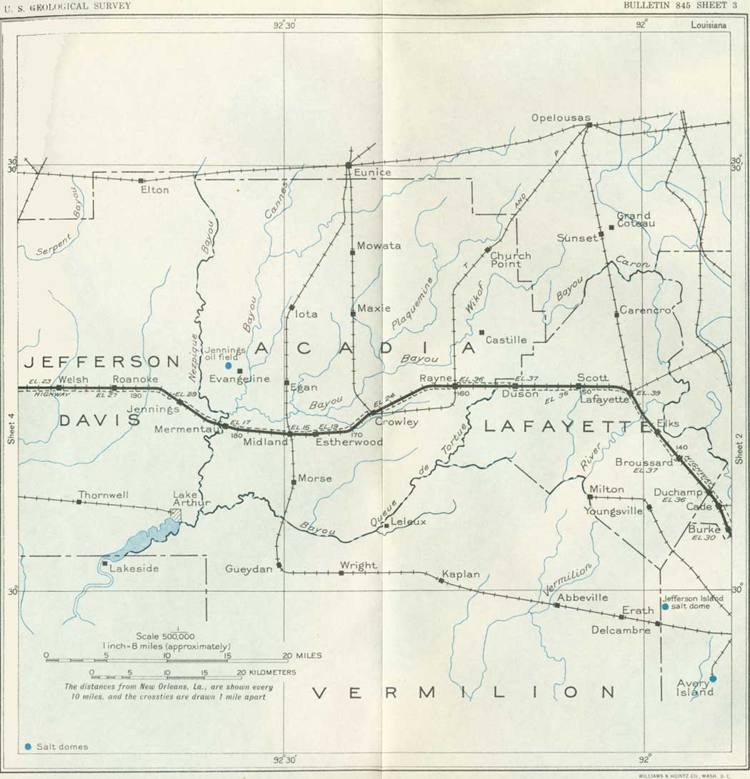
SHEET No. 3 (click in image for an enlargement in a new window) |
An important resource of southwestern Louisiana is underground water, which yields flowing wells at moderate depth in the lower lands and water available for pumping in the higher areas. The wells are mostly from 200 to 300 feet deep and obtain their supplies from gravel and sand in the younger formations.
|
Cade. Elevation 32 feet. New Orleans 134 miles. |
At Cade is the junction with a branch railroad which goes to Port Barre, a small town on Bayou Cortableau about 40 miles north. The first station north of Cade on this branch line is St. Martinsville, above referred to in connection with the legend of Evangeline. Cade is surrounded by cane fields, and considerable quantities of cane and other farm products are shipped here and at Burke and Duchamp sidings.
|
Broussard. Elevation 37 feet. Population 806. New Orleans 140 miles. |
At Billeaud, a mile east of Broussard, a large sugar refinery just north of the railroad utilizes cane from the adjoining region. Broussard is an old town sustained in large part by the sugar industry and surrounding farms. It was named for a French captain by one of his descendants when the town was established after the Civil War. The rolling country is covered with cane fields that extend at intervals to Lafayette, where they give place to rice. Much pepper also is raised.
The region hereabouts is called the Attakapa country, from the Indians who originally occupied it, of whom now a very few known descendants remain near Grand Lake. They were nearly annihilated by neighboring tribes, notably the Choctaws, at a battle on a hill about 3 miles east of Billeaud, just before the white settlers came into the country. Many of their burial mounds occur along the banks of Bayou Teche, and their weapons and utensils are found occasionally.
|
Lafayette. Elevation 39-1/2 feet. Population 14,635. New Orleans 146 miles. |
Three miles northwest of Broussard the railroad crosses the Vermilion River near the place where the first settlement was made in this region. It was located at the head of navigation and was of considerable importance as a trading post under the successive names of Little Manchac, Pinhook, Vermilionville, and Lafayette. Here also in 1863 occurred an important battle of the Civil War when the Union troops moved through the Teche country and established a camp at Lafayette. Lafayette, in the heart of the Attakapa country, has nearly doubled its population in a decade, owing to its advantages as a railroad and general commercial center. A branch railroad runs to Alexandria, on the Red River. The mean annual temperature here is 65°; the average for July is 81° and for January 52°. Lafayette is the westernmost of the old French towns, and many descendants of French settlers are included in its population. In the southern edge of the town is the Southwestern Louisiana Institute. On exhibition at the railroad station is the first locomotive used on the Morgan Line, the predecessor of the Southern Pacific in this section. It contrasts strongly with modern locomotives.
According to the United States census, in 1929 Lafayette Parish produced 18,394 bales of cotton, 135,524 bushels of rice, 146,246 tons of sugarcane, 45,027 pounds of figs, 166,045 bushels of sweetpotatoes, 14,144 bushels of Irish potatoes, 14,262 bushels of soybeans, and 505,445 bushels of corn. Oranges and pecans are also produced.
There is a salt dome at Anse La Butte, 5 miles northeast of Lafayette, but holes drilled in it to a depth of 3,400 feet found only a small amount of petroleum.
From Lafayette the railroad goes due west for 16 miles to and beyond Rayne over wide prairies with an average elevation near 35 feet. Three miles west of Scott siding the Bayou Queue de Tortue (French, tail of a tortoise) is crossed. Rice fields soon begin to be conspicuous, especially near Duson, a siding named in honor of a Canadian refugee settler of early days.
|
Rayne. Elevation 36 feet. Population 3,710. New Orleans 160 miles. |
The village of Rayne is in an important agricultural community, with its chief interest in rice, which is raised over a wide area in the vicinity. The fields are irrigated by water pumped from bayous and wells. The Southern Pacific Railroad here crosses a branch of the Texas & Pacific Railway which connects Opelousas and Crowley.
|
Crowley. Elevation 24 feet. Population 7,656. New Orleans 168 miles. |
Crowley, the parish seat of Acadia Parish, is now the center of the great rice industry of southwestern Louisiana. About three-fourths of the area of the parish is in rice, which is irrigated by 300 miles of canals and water from 125 wells. The principal supply of underground water here is found about 300 feet below the surface, and considerable water is also obtained at depths of 17 to 60 feet. One of the large canals is crossed between Rayne and Crowley. It is claimed by local authorities that one-third of the rice produced in the United States is raised within 30 miles of Crowley. Acadia Parish alone produced 16,317,463 bushels of rough rice in 1929 (Fifteenth Census). There are many rice mills where the rice is cleaned and polished, with an annual production averaging 1,500,000 barrels of 162 pounds, according to the Crowley Chamber of Commerce. Rice is milled to cull out broken and small material and remove the hull and the several thin layers that surround the grain, a process which robs it of valuable food elements. Most of the rice to be exported has to be coated with a very thin film of talc in glucose. A large part of it is shipped to Puerto Rico. Rice requires a generous supply of water, not only for the growth of the rice plant but to kill weeds that would otherwise choke it. This water is pumped from wells and bayous and in large amount from the Sabine River. Many of the canals and ditches that bring the water, some of them from long distances, are crossed by the railroad. Fortunately, in most seasons there is an abundant water supply, but it is found that in some bayous strong pumping causes the backing up of brackish water, which is deleterious. The pumping is done by steam and electricity, with oil for fuel, and most of the water is supplied by companies that irrigate their own fields and sell water to others. Some of the batteries of pumps require from 400 to 800 horsepower. The fields are crossed by a network of small ditches like furrows, with low banks to retain the water.
Ordinarily the irrigation of rice costs about one-fifth of the value of the yield, which is 40 to 50 bushels to an acre. Rice sprouts in two or three weeks after planting and soon grows to 8 to 12 inches, when it is flooded until practically mature.
The extensive cultivation of rice in this region is relatively modern, dating back to 1894 and 1895, when the first large pumps were introduced near Crowley. The early Acadians planted small areas of rice along the lowlands and in various dammed areas, but the drainage of all these tracts was difficult in wet weather, and the crops failed in dry years.
|
Estherwood. Elevation 19-1/2 feet. Population 40.* New Orleans 173 miles. Midland. Elevation 18 feet. Population 80.* New Orleans 176 miles. Mermentau. Elevation 17 feet. Population 394. New Orleans 181 miles. |
From Crowley a railroad runs north, serving the rice country as far as Alexandria. Just west of Estherwood a wide ditch is crossed which carries water for the irrigation of the extensive rice fields in the neighborhood. Most of the prairie land is utilized for this crop, but narrow wooded strips remain along the streams.
At Midland are branch railroads, one going north to Eunice and Mamou and the other south to Gueydan and Abbeville. The old village of Mermentau, with a quaint ancient grave-yard on its main street, is built on the east bank of the Mermentau River. This stream, resulting from Bayou des Cannes and Bayou the confluence of Bayou Nezpique, is bordered by swamps in which many cypress trees remain with their festoons of Spanish moss. It empties into Lake Arthur, 15 miles south, a famous resort for hunting ducks and geese and for fishing. There is a local tradition that the vessels of the pirate Lafitte (see p. 13) made a practice of ascending this river to sell stolen slaves.
|
Jennings. Elevation 29 feet. Population 4,036. New Orleans 186 miles. |
Jennings, the parish seat of Jefferson Davis Parish, is a local headquarters for rice and other agricultural products. The rice crop in this parish was 4,717,628 bushels in 1929, according to the census returns, which showed also 182,439 bushels of corn and 4,185 bales of cotton. A very special industry is the extensive cultivation of Bermuda or Easter lilies, which are shipped from this place all over the United States. The pretty town is built on a low, flat ridge between the valleys of the Mermentau River and Bayou Chene, in a region of wide prairies with many rice fields.
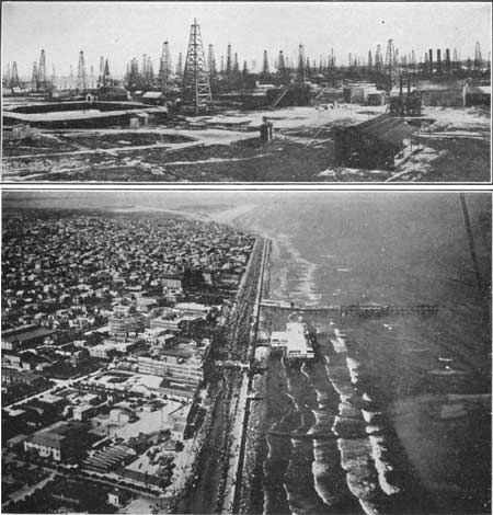
Five miles northeast of Jennings is the productive Jennings oil field, which obtains petroleum from a sharp local doming of the strata. The derricks are not visible from trains owing to timber along Bayou Nezpique. They are shown in Plate 5, A. This field has been described by Barton and Goodrich. It was one of the earliest oil developments on the Gulf coast, having given its first manifestation of oil eight months after the strike at Spindletop in 1901. In 1906 the field had a production of more than 9,000,000 barrels, but finally the amount diminished, and the yield in 1930 was only 527,834 barrels. It is estimated that in all about 40,600,300 barrels has been produced from an area of about 300 acres, which is a larger production than that of any other field in Louisiana. Some of the borings found considerable gas. Salt was reached at a depth of 3,716 feet, but most of the oil was obtained at 1,700 to 2,000 feet.19 For several years the oil from this field sustained a refinery at Jennings.
19The subsurface geology (see table, p. 19) showed clay (Beaumont) to 90 feet; sand (Lissie and Citronelle), 90 to 1,100 feet; clay, mainly Pascagoula and Hattiesburg(?), 1,100 to 2,800 feet; and sand (Catahoula), 2,800 feet to an unknown depth. Probably Jackson strata were penetrated in the deeper holes, several of which were from 7,294 to 7,447 feet deep. One dry hole 8,903 feet deep was abandoned in hard blue shale regarded by some geologists as Oligocene.
|
|
PLATE 5.—A (top), OIL FIELD NEAR JENNINGS, LA., IN 1928.
Total production more then 40,000,000 barrels from 504 wells. B (bottom), PART OF GALVESTON, TEX. General view from an airplane. Shows the sea wall. |
Southwest of Jennings, between the railroad and the Gulf of Mexico, are noted hunting and fishing grounds with a great variety of fish and wild fowl.
|
Welsh. Elevation 23 feet. Population 1,514. New Orleans 197 miles. |
A short distance beyond Jennings, just before crossing Bayou Chene, the railroad turns due west, a course which is continued 50 miles to Edgerly, over prairies with an average elevation of 20 feet. While many parts of the region are under cultivation for rice, other crops are raised, including considerable cotton. There are many cattle in the numerous pastures.
Three miles west of Welsh there is another low local dome, known as the Welsh oil field, the derricks of which are mostly about a mile north of the railroad. About 90 wells have been drilled here, and some of them yielded a small production for a few years. Much of the oil was used for lubrication on the locomotives of the Southern Pacific lines. (Turn to sheet 4.)
| <<< Previous | <<< Contents >>> | Next >>> |
bul/845/sec3.htm
Last Updated: 16-Apr-2007