
|
Geological Survey
The Geologic Setting of the John Day Country, Grant County, Oregon |
ROAD LOG OF THE JOHN DAY "LOOP"
(continued)
| K. 5.0 | Basalt Dike. A basalt dike 15 feet wide cuts basalt flows in bluffs north of the road and forms a wall 20 feet high in places; it is visible also across the river. | ||
| L. 11.2 | Parallel Dikes. Two prominent parallel dikes, among others, form crests of hogbacks south of the river. A small tapering dike cuts pink and white beds of the John Day Formation in the river bluff. This dike is the southwest end of an irregular intrusive mass of basalt in which the river has cut a steep-walled gorge. | ||
| M. 13.2 |
Basalt Intrusion. The road is cut through 300 feet of basalt intruded into the John Day Formation. Both contacts are well exposed. The basalt—when molten—baked and reddened 3 to 6 inches of the adjacent beds. (At 13.9 the highway crosses the North Fork of the John Day River and follows the Cottonwood Creek Valley) | ||
| N. 18.0 |
Irregular Dikes. Above the highway several small irregular basalt dikes cut the white beds of the John Day Formation. Parts of the largest dike are 10 to 15 feet high. | ||
| |||
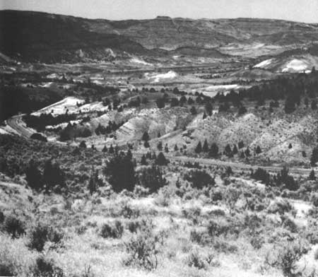
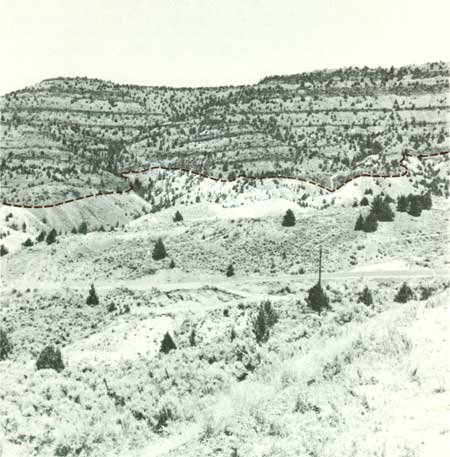
| O. 20.1 |
Cottonwood Creek Valley. The view northwestward down cottonwood Creek toward Monument (Fig. 9) exemplifies the development of broad valleys by erosion in soft beds of the John Day Formation under the gently warped Picture Gorge Basalt. To the south, the valley ends against massive rocks of the Clarno Formation which were raised as a block by movement along the Hamilton fault. The red beds are in the lower part of the John Day Formation. Note the contrast between the irregular massive in trusion in the valley bottom west of Monument and the thin regular basalt flows. On your right, the irregular contact between the John Day Formation and Picture Gorge Basalt reveals an ancient landscape buried under lava flows (Fig. 10). Some of the flows wedge out against former hillsides and one, marked by the dry falls, fills an old valley. For the next two miles, to the Sunken Mountain viewpoint, the road winds through landslides in the John Day Formation and Picture Gorge Basalt. | ||
| |||
| P. 22.0 |
Sunken Mountain. A small landslide in the lower part of the John Day Formation is called Sunken Mountain. When the valley wall was over-steepened by normal stream erosion, the jumbled material in the lower part broke away and slid down from the steep bare slopes above. Absence of tilted trees indicates that the slide is not very active now. The bare "badland" slopes are being eroded by rain wash. The cliffs of the John Day Formation, which the road climbs half a mile farther east, are the result of rapid but normal headward erosion by the creek. Eventually, because of its lower elevation and steeper gradient, this branch of Cottonwood Creek will intercept and behead Deer Creek just east of Hamilton. A photogenic perspective view of the future stream piracy can be seen from the road on the ridge just south of Sunken Mountain, about a mile and a half from the highway. | ||
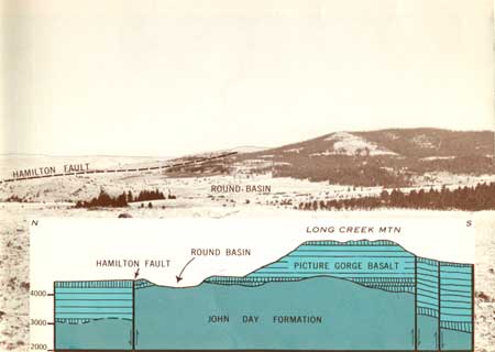
| Q. 26.4 |
Long Creek Mountain. An uplifted block of Picture Gorge Basalt 1400-1500 feet thick forms Long Creek Mountain; Round Basin is eroded in the John Day Formation on which the basalt rests (Fig. 11). The base of the basalt can be seen in road cuts on either side of Basin Creek. The Hamilton fault follows the gulch to the left just below the parking area, goes up the tree-filled gulch across Basin Creek, along the low ridge at the northeast edge of Round Basin, and then along the northern foot of the mountain. The small slab of basalt south of the fault in Basin Creek has been tilted about 10° north by downward drag along the fault. The Hamilton fault system extends about 15 miles farther east. (In Long Creek turn right—south—on U. S. Highway 395). | ||
| |||
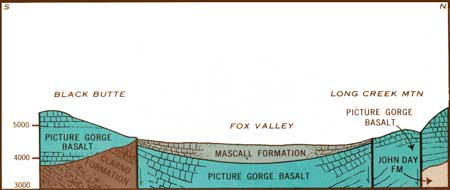
| R. 99.5 |
Fox Valley. Down-warped flows of Picture Gorge Basalt dip toward Fox Valley from all sides to form a basin (Fig. 12). The valley is eroded out of ashy beds and gravels of the Mascall Formation which fill the center of the basin to an estimated depth of 1000-1200 feet. Faults form parts of the northern and southern borders of the basin. The straight, timbered, northward-facing steep slope less than a mile southeast of the viewpoint marks a fault. | ||
| |||
| <<< Previous | <<< Contents >>> | Next >>> |
inf/john_day/sec3b.htm
Last Updated: 28-Mar-2006