
|
Geological Survey
The Geologic Setting of the John Day Country, Grant County, Oregon |
ROAD LOG OF THE JOHN DAY "LOOP"
(continued)
| S. 180.3 |
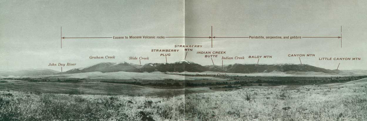
Strawberry Range. This range and the Aldrich Mountains form a mountain range 50 miles long; Strawberry Mountain, altitude 9038 feet above sea level, is its highest peak. The eastern two-thirds of the Strawberry Range (Fig. 13) was raised as a great block by uplift on the John Day fault, which follows the northern base of the mountains. The rocks in Strawberry Mountain and to the east are mostly lavas which poured out over the land, whereas the Canyon Mountain part of the range consists of gabbro and peridotite which were intruded at great depth, like granite. The valleys in the higher parts of the range, above about 5000 feet, were widened from narrow V's to their broad U profiles by glaciers during the Pleistocene Epoch, or Great Ice Age. The alluvial fans (Rattlesnake Formation) in front of the mountains were built up of bouldery gravels and finer sediments. These materials were eroded from the mountains, carried by streams down the steep narrow canyons, and spread out on the valley floor. Because much more material came into the John Day River from the Strawberry Mountains than from the lower mountains to the north, the river was pushed to the north side of its wide valley. Faulting and erosion have completely destroyed the cones of the volcanoes from which the volcanic rocks were erupted in Miocene and Pliocene time. | ||
| |||
| T. |
Strawberry Lake and Vicinity. At Strawberry Camp, about 12 miles south of Prairie City, the broad floor and steep walls of Strawberry Creek valley indicate that the valley has been glaciated. The precipitous cliffs and rounded valley bottom above Strawberry Lake are characteristic of glaciated mountains (Fig. 15). Strawberry Lake is dammed by landslides which probably came from the west wall of the valley after the glacier melted and left the valley wall over-steepened. The hummocky surface and blocky material in the slide are well shown along the last half mile of the trail to Strawberry Lake. Strawberry Falls mark the front of a glacial step over a massive flow of platy andesite. Little Strawberry Lake is dammed by a low glacial moraine.
Most of the lavas in the Strawberry Mountains were erupted from a central vent about 4000 feet in diameter which is exposed in the cliffs above Little Strawberry Lake. The pinnacles known as "Rabbit Ears," above the prominent talus in figure 15, are of vent breccias that consist mostly of welded blocks of scoriaceous basalt, but also contain volcanic bombs which were blown out as blobs of fluid lava. Huge blocks of the breccia have fallen onto a gentle bare slope west of Little Strawberry Lake. The massive, vertically-jointed cliffs are formed of basalt which cooled slowly and formed a plug in the throat of the volcano after the eruptions ceased. The thin irregular scoriaceous andesite flows, which are exposed in the cliffs east of Little Strawberry Lake adjoining the plug, contrast strikingly with the massive even flows of the Picture Gorge Basalt. Tilting of the Strawberry Mountain block is shown by the southward dip of all the flows in the area. The flows in the cliffs west of Strawberry Lake, for example, originally must have sloped northward away from the vent where they erupted. Their present southward dip of about 15° therefore indicates that they have been rotated more than 15° by faulting, partly along the northern edge of the mountain range. (Fig. 14). | ||
| |||


| <<< Previous | <<< Contents >>> | Next >>> |
inf/john_day/sec3c.htm
Last Updated: 28-Mar-2006