
|
Geological Survey Professional Paper 132—A
Rock Formations in the Colorado Plateau of Southeastern Utah and Northern Arizona |
SEDIMENTARY ROCKS.
(continued)
CARBONIFEROUS SYSTEM.
Goodridge formation.—The Goodridge formation, which has been described by Woodruff,14 is best exposed at the type locality on the Honaker trail in San Juan Canyon near Goodridge, where the canyon has been carved into it to a depth of 1,338 feet without revealing the base. It is of marine origin and consists of sandstone, sandy shale, and cherty limestone, with gray limestone predominating in the lower 500 feet and sandstone and shale in the upper portion. (See Pls. III, A, and IV, C.) Red is the most common color of the beds in the upper 700 feet. The base of the formation is nowhere exposed, and therefore its relation to older rocks is not known. A less complete section of the formation—about 1,000 feet—is exposed in another anticline east of Goodridge. About 1,500 feet of it is exposed in Cataract Canyon on the Colorado. (See Pls. II, III, B and C.) A deep well drilled in the Circle Cliffs by the Ohio Oil Co. penetrated in its lower part 1,582 feet of white sandstone and limestone that may represent the Goodridge formation.
14 Woodruff, E. G., op. cit., pp. 80-85.
|
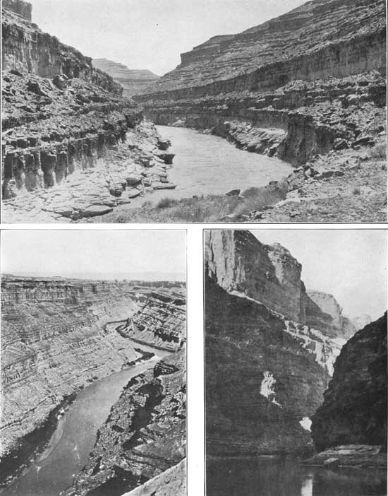
| PLATE III—A (top), VIEW LOOKING DOWN SAN JUAN CANYON, UTAH, AT A POINT 9 MILES BY STREAM ABOVE HONAKER TRAIL. Canyon has been cut in Goodridge formation. Photograph by Robert N. Allen. B (bottom, left), VIEW LOOKING DOWN GREEN RIVER TOWARD ITS JUNCTION WITH COLORADO RIVER, UTAH. Canyon cut in Goodridge formation. Photograph by Sidney Paige. C (bottom, right), VIEW IN CATARACT CANYON OF THE COLORADO, UTAH. Goodridge formation forms lower part of canyon walls and Coconino sandstone the upper part. These two formations are probably separated by beds that are equivalent to the Supai (?) formation of the San Juan Canyon. Photography by Sidney Paige. |
|
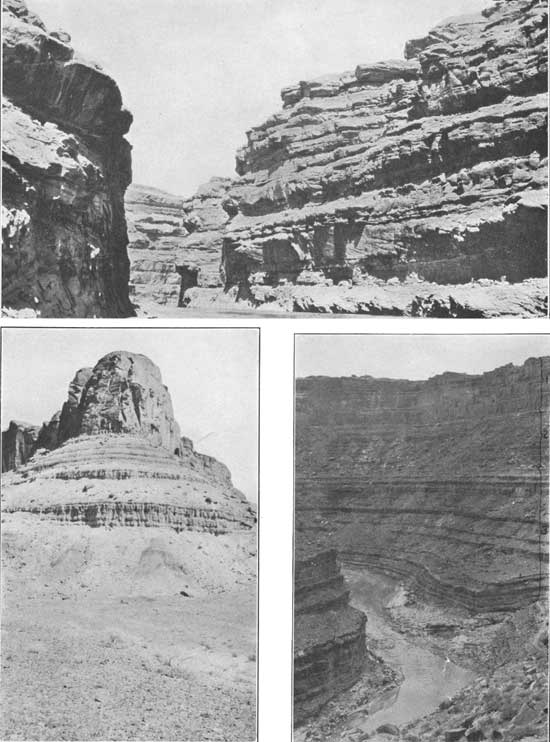
| PLATE IV—A (top), VIEW LOOKING DOWN SAN JUAN CANYON, UTAH, AT A POINT BETWEEN CLAY HILL CROSSING AND THE MOUTH OF MOONLIGHT CREEK. Coconino sandstone forms canyon walls. Photograph by H. D. Miser. B (bottom, left), VIEW NEAR COLORADO RIVER 2 MILES BELOW MOUTH OF TRACHYTE CREEK, UTAH. Showing Chinle formation about 320 feet thick, capped by Wingate sandstone. Part of wide bench in foreground is on Shinarump conglomerate. Photograph by C. R. Longwell. C (bottom, right), VIEW LOOKING DOWN SAN JUAN CANYON AT THE MOUTH OF SLICKHORN GULCH, UTAH. 1, Coconino sandstone; 2, Supai (?) formation; 3, Goodridge formation. The rapid is produced by a boulder bar at the mouth of Slickhorn Gulch. Photograph by Robert N. Allen. |
Fossils are abundant and are distributed throughout the type section from a horizon near the base to the top. G. H. Girty, who has studied the faunas, makes the following statement:
The Goodridge formation, as described by Woodruff14 comprises two widely different faunas. The lower fauna, which contains almost no true Mollusca, changes abruptly, at bed No. 55 of his published section, to one that contains almost nothing else. The base of the bed as measured by Miser is 314 to 324 feet below the top of the formation. The character of the change suggests that it may not be as significant as the degree of the change might indicate.
The two sections that naturally invite comparison with the Goodridge are the San Juan section, Colorado, to the east, and the Grand Canyon section, to the west. [See P1. I.] As I suggested in 1912, the general faunal resemblances would tend to correlate the upper part of the Goodridge with the Rico formation in the San Juan region and with the upper part of the Redwall limestone [old usage of Redwall] in the Grand Canyon region. On the same grounds the lower part of the Goodridge would be correlated with the Hermosa formation of the San Juan, which underlies the Rico. In the Grand Canyon section, however, the lower part of the Goodridge has no equivalent that can at present be recognized, but it is closely related faunally to the Magdalena limestone of New Mexico.
Developments of the last ten years have brought about an assignment of the Rico formation to the Permian (?), while the upper part of the old Redwall limestone is referred to the Pennsylvanian and now included in the Supai formation. It is evident that the upper part of the Goodridge can not be correlated with both these formations and yet these assignments be correct. An error evidently exists, but it can not at present be located. The correlations here adopted seem the natural ones, and it is thought better to continue them for the present and to leave adjustments of age determinations to a future day and more satisfactory evidence.
At present, therefore, the upper part of the Goodridge can not be assigned with assurance to any epoch, but the greater part of the formation is certainly Pennsylvanian. It is evident from Mr. Girty's remarks that any attempt to match the Goodridge with a part of the standard Grand Canyon section must be considered as tentative only. This fact should be borne in mind in connection with the columnar sections (Pls. I, II) offered in this paper.
Sandstone and limestone beds of the Goodridge formation supply the oil in the San Juan field, as noted by Gregory and Woodruff. Some of these oil-bearing beds are near the top of the formation, but others are much deeper, the lowest being 1,300 feet below the top. Oil seeps occur at several places along the bottom of the San Juan Canyon. The largest extends for 1-1/4 miles above the mouth of Slickhorn Gulch, and the oil at this locality comes from westward-dipping beds along and near a fault about 520 feet below the top of the Goodridge.
Supai (?) formation.—The Goodridge formation in the San Juan region and in Cataract Canyon is overlain by red sandy shale and shaly sandstone. (See Pl. III, C.) Gregory notes that no definite unconformity is recognized at the top of the Goodridge,16 but there appears to be a transition to the red beds above through limestone conglomerate that may represent a gradual change from marine to continental conditions. At the mouth of Slickhorn Gulch, on the west side of the San Juan oil field, these higher red beds are 380 feet thick. (See P1. IV, C.) In view of their lithologic character and their position immediately beneath the Coconino sandstone, a possible correlation with Noble's Hermit shale is suggested; but in the absence of fossils the beds are correlated doubtfully with the upper part of Noble's Supai formation, which has a much wider known distribution than the Hermit shale. Woodruff and Gregory referred these red beds to the lower part of the Moenkopi formation, which is now recognized as Triassic. (See Pls. I and II.)
16Gregory, H. E., Geology of the Navajo country: U.S. Geol. Survey Prof. Paper 93, p. 21, 1917.
In the head of Marble Canyon about 500 feet of red shale and sandstone containing beds of blue limestone in their lower part were observed beneath the Coconino sandstone. The highest of these beds may be equivalent to Noble's Hermit shale, but the lowest are probably equivalent to his Supai formation.
Coconino sandstone.—The Coconino sandstone has yielded no determinable fossils, but it is recognized in southern Utah by criteria other than its peculiar lithologic character. In Marble Canyon, southwest of Lees Ferry, Ariz., the sandstone is present in its normal position beneath the Kaibab limestone, which in turn is unconformably overlain by the Lower Triassic Moenkopi beds. In Circle Cliffs the same relations are seen but the Kaibab is much thinner than at Lees Ferry and localities farther west. In and about Cataract Canyon and on the San Juan the Kaibab is absent and the Moenkopi rests unconformably on a thick sandstone that has all the characteristics of the Coconino. Gilbert recognized this relation near Cataract Canyon and referred to the sandstone as the "Upper Aubrey sandstone," the name used at that time for the Coconino in the Grand Canyon. (See Pls. I, II, IV, C, and V, B and C.)
The sandstone here called Coconino has been traced by B. S. Butler,17 F. L. Hess,18 H. E. Gregory,18 C. R. Longwell, and H. D. Miser practically the entire distance from Cataract Canyon to the San Juan oil field by way of White Canyon. The three large natural bridges in White Canyon are stated by Hess and Gregory to have been formed in this sandstone. On the San Juan the Coconino is exposed in a small area on the crest of an anticline at Zahns Camp, but farther upstream it is exposed over large areas, being the surface formation in the part of Moonlight Valley in which Train and Organ rocks are situated and also in the broad dissected plateau between the Clay Hills and the San Juan oil field. (See Pl. IV, A and C.) The eastern part of the plateau is known as Cedar Mesa. Woodruff19 states that eastward from Cedar Mesa the sandstone grades completely into red sandy shale on the southeast side of the oil field. This shale and the equivalent sandstone were included by Woodruff20 and Gregory21 in their Moenkopi formation. (See Pls. I and II.)
17Butler, B. S., The ore deposits of Utah: U. S. Geol. Survey Prof. Paper 111, pp 619-620, 1920.
18Oral communication.
19Woodruff, E. G., op. cit., p. 86.
20Woodruff, E. G., op. cit., pp. 86-87.
21 Gregory, R. E., Geology of the Navajo country: U. S. Geol. Survey Prof. Paper 93, pp. 29-30, 1917.
The sandstone is massive and highly cross-bedded, and its color is creamy white, though on Cedar Mesa much of it is tan. The grains are fine to medium in size, and as a rule the cement of calcium carbonate is sufficient to make the rock fairly firm, although in places it is friable. The greatest thickness observed is in Cataract Canyon, where it measures nearly 1,000 feet. In the Circle Cliffs only the top of the formation can be seen, but the deep well mentioned above penetrates white sandstone hundreds of feet thick immediately beneath the Kaibab and then passes through beds that are probably the equivalent of the Supai (?) formation. The Coconino, as well as most of the supposed Supai there, consists of white sandstone, so that these two formations can not be separated in the well log. Their combined thickness is 1,550 feet. Near the mouth of Moonlight Creek on the San Juan the thickness of the Coconino is about 600 feet; at the mouth of Slickhorn Gulch, also on the San Juan, it is about 400 feet at Lees Ferry it is 300 feet; in the Grand Canyon it ranges from 250 to 350 feet; and to the west it gradually decreases,22 the formation losing its identity in southern Nevada.23 Thus it is evident that the sandstone thickens consistently toward the northeast in the area of its known distribution.
22 Reeside, J. B., and Bassler, Harvey, Stratigraphic sections in southwestern Utah and northwestern Arizona: U. S. Geol. Survey Prof. Paper 329, pp. 57-58, 1922.
23 Longwell, C. R., Geology of the Muddy Mountains, Nev., with a section to the Grand Wash Cliffs in western Arizona: Am. Jour. Sci., 5th ser., vol. 1, p. 47, 1921.
Kaibab limestone.—Typical Kaibab limestone consisting of white and yellow dolomite and limestone with numerous chert nodules is present in the Circle Cliffs, but its thickness is only 150 feet, as compared with 250 feet at Lees Ferry, 400 to 600 feet in the Grand Canyon,24 and 1,000 feet in northwestern Arizona and south western Utah.25 (See Pl. V, A.) It is not found in Cataract Canyon, in the Henry Mountains,26 or along San Juan River. (See Pls. I and II.) Thus it appears to thin progressively toward the northeast, With the thickening of the Coconino sandstone in this direction, suggesting lateral gradation of the limestone into the sandstone at the top of the Coconino. It is probable, however, that a large part of the thinning is due to beveling during the erosion interval recorded by the unconformity at the base of the Triassic. This problem is of considerable interest, especially to the paleogeographer, for under the first interpretation the Kaibab shore line certainly lay at no great distance east of the Circle Cliffs, whereas the alternate explanation permits a much greater extension of the Kaibab sea eastward. Study of the Kaibab faunas gives weight to the suggestion that pre-Triassic erosion beveled progressively eastward, for the fauna found in the Circle Cliffs is of the "normal Kaibab" type27 and not the upper "Bellerophon limestone" fauna. Therefore it is probable that the Kaibab present in the Circle Cliffs is lower stratigraphically than the top of the Kaibab in the Grand Canyon and the "Bellerophon" in the Park City formation of the Uinta country.
24 Noble, L. F., The Shinumo quadrangle, Grand Canyon district, Ariz.: U. S. Geol. Survey Bull. 549, p. 70, 1914.
25 Reeside, J. B., and Bassler, Harvey, op. cit., pp. 69-76.
26 Gilbert, G. K., Geology of the Henry Mountains, p. 4, U. S. Geog. and Geol. Survey Rocky Mtn. Region, 1880.
27 See Reeside, J. B., and Bassler, Harvey, op. cit., pp. 66-67.
|
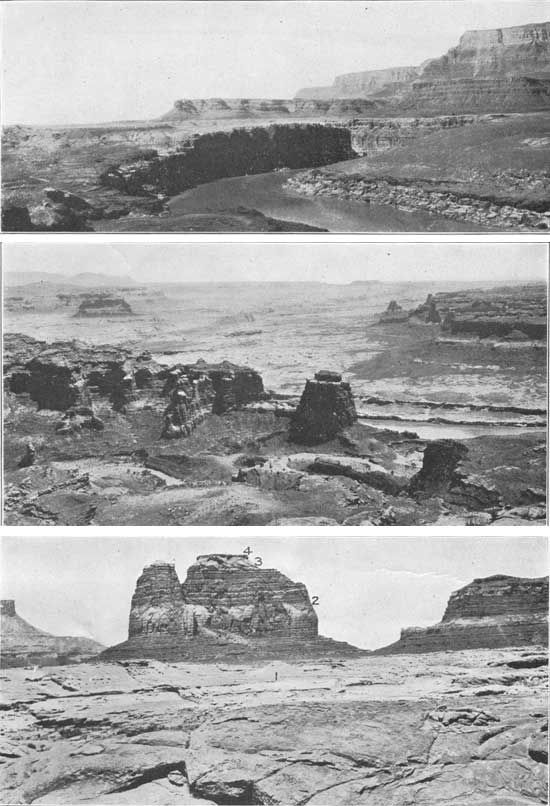
| PLATE V—A (top), VIEW LOOKING SOUTHWEST DOWN HEAD OF MARBLE CANYON FROM POINT NEAR LEES FERRY, ARIZ. Platform in foreground is underlain by Kaibab limestone; next higher platform reveals the Moenkopi formation and is capped by Shinarump conglomerate; the high Vermilion Cliffs, to the right, are formed by Wingate and Navajo sandstones. Chinle formation is exposed on steep slope below Vermilion Cliffs. Photograph by Kirk Bryan. B (middle), VIEW LOOKING UP COLORADO RIVER FROM A HIGH POINT NEAR THE MOUTH OF CRESCENT CREEK, UTAH. Crescent Creek in foreground. The Colorado is deeply incised in the Coconino sandstone, which forms the light-colored platform. Moenkopi formation in the foreground is stripped from this platform. Photograph by C. R. Longwell. C (bottom), EROSION REMNANTS STANDING ON PLATFORM OF COCONINO SANDSTONE NEAR MOUTH OF FREMONT RIVER, UTAH. 1, Coconino sandstone; 2, lower member of Moenkopi formation; 3, De Chelly (?) sandstone lentil of Moenkopi formation; 4, conglomerate at base of upper member of Moenkopi formation. Photograph by C. R. Longwell. |
| <<< Previous | <<< Contents >>> | Next >>> |
pp/132-A/sec2a.htm
Last Updated: 08-Aug-2008