
|
Geological Survey Professional Paper 446
Geology of the Guadalupe Mountains, New Mexico |
GEOGRAPHY
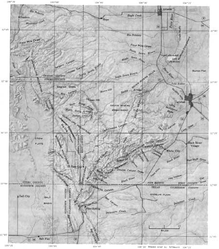
The area herein described lies in Eddy and Otero Counties along the south boundary of eastern New Mexico. The area is irregular in outline, but it consists of nearly 1,000 square miles which lie entirely between lat 32°00' and 32°30' N. and long 104°15' and 105°00' W. (fig. 1).
|
| FIGURE 1.—Index map of Guadalupe Mountains region showing location of mapped area, major geographic features, and certain features referred to in text but not shown on the geologic map. (click on image for a PDF version) |
Included in the area are most of the northern part of the Guadalupe Mountains, part of the nearby Brokeoff Mountains, and a considerable area of plains. The Guadalupe Mountains are basically a dissected and tilted plateau of moderate to high relief. The Brokeoff Mountains consist of a series of north-northwestward-trending ridges and valleys of moderate relief. The plains areas are characterized by very low to moderate relief. Altitudes above sea level range from a minimum of about 3,220 feet where the Black River crosses the east boundary of the mapped area to 7,444 feet in the Guadalupe Mountains near the south edge of the area (p1. 1).
The climate is semiarid; the average annual precipitation ranges from about 13 inches in the lower elevations to perhaps 20 inches in the highest part of the mountains. Most of the precipitation falls between May and October.
Vegetation is sparse throughout most of the mapped area. Areas at lower elevations exhibit a dry-climate flora typical of the Sonoran life zone, whereas areas at the higher elevations exhibit thin juniper forests and scattered stands of Ponderosa pine typical of the transition or foothills life zone.
More than 90 percent of the area is used for grazing by cattle, sheep, and goats, and less than 1 percent is irrigated farmland. The remainder has been set aside as Carlsbad Caverns National Park.
All parts of the mapped area are readily accessible, and no point is more than 2 or 3 miles from a motor road. Some of the unimproved roads, however, are suitable only for trucks or four-wheel drive vehicles.
| <<< Previous | <<< Contents >>> | Next >>> |
pp/446/sec1.htm
Last Updated: 13-Feb-2008