
|
Geological Survey Professional Paper 669
The Colorado River Region and John Wesley Powell |
PIONEER STRATIGRAPHIC WORK—THE PRE-POWELL ERA
The earliest studies of Grand Canyon geology were made by Jules Marcou in 1853-54 and by J. S. Newberry in 1857-58. Marcou was a member of Lt. Amiel W. Whipple's expedition, which crossed northern Arizona while exploring for the U.S. Pacific Railroad; he examined strata similar to those of the Grand Canyon but in an area farther south (Marcou, 1856). Newberry, as geologist for a War Department expedition under Lt. J. C. Ives, recorded the Grand Canyon sections at Diamond Creek, along "Cascade River" (Havasu), and on "mesa at Camp 70" which was at Aubrey Cliffs northwest of Seligman (Newberry, 1861). Both Marcou and Newberry attempted to classify and correlate the formations of the region; their conclusions were remarkable, considering the difficult conditions under which they worked and the state of general knowledge at the time.
The uppermost formation exposed in the canyon, now known as the Kaibab Limestone, was correlated by Marcou (1856, p. 170) with the European Magnesian Limestone of Permian age because of the high magnesium content in the rock where examined; this same limestone was correlated with the Upper Carboniferous by Newberry (1861, p. 70-73) on the basis of certain "known Carboniferous fossils." Subsequently, Marcou has been proved correct, although his evidence was not valid (that is, the chemical composition of the rock is insufficient basis for correlation), whereas Newberry was in error, though his reasoning was correct (that is, the fossils, including numerous productids, that he discovered were later shown to be Permian and not Carboniferous forms).
The Redwall Limestone, which forms a sheer cliff midway in the walls of the Grand Canyon, was considered in the 1850's as it is today, a stratigraphic marker to which less readily identified units both above and below could be referred. The Redwall was correlated correctly, as has since been demonstrated, with the "mountain limestone" of England ("lower Carboniferous" age) by both Marcou and Newberry. Evidence for this conclusion included brachiopods (listed as Spirifers), corals, and other fossils, as well as lithologic resemblances.
Resting on granite and underlying the "Mountain limestone" of Marcou in an area east of Picacho Mountain, south of Grand Canyon, is a reddish-brown sandstone (the Tapeats Sandstone of Cambrian age) which, probably because of its color and lithology, Marcou correlated with the "Old Red" or Devonian sandstone of England. This same unit farther north in Grand Canyon is mostly brown to purple. Newberry correlated it on the basis of lithology and stratigraphic position with the "Potsdam sandstone" (Cambrian age) of New York; thus, he was correct and Marcou was wrong in the age assignment.
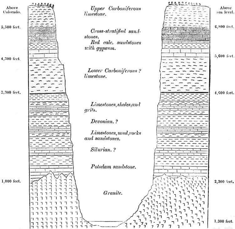
Between the basal sandstone and the Redwall are strata that Newberry (1861, p. 55-56) referred to the "Silurian?" and "Devonian?" in his figure 12 (1861, p. 42; reproduced as fig. 2 in this publication). Newberry seemed very uncertain of the age of these strata, especially because recognizable fossils were not found. He was influenced in his correlations by lithologic character "much like that of some of the Chemung rocks" (Devonian of New York State) (1861, p. 56), and he noted the resemblance of certain structures to the "intermingled branches of Chaetetes which cover the surfaces of some of the Silurian strata" (1861, p. 56). The upper rocks in this sequence, which apparently were Included with the Redwall by Marcou, have indeed proved to be of Devonian age, although even today little is known about them. The lower rocks that Newberry assigned to the Silurian? are absent in the area examined by Marcou; in Grand Canyon, where represented, they are now classed as Cambrian (Muav Limestone).
Newberry must also be credited for his attempts to reconstruct the history of deposition in the Grand Canyon area. He offered suggestions on paleogeography, genesis of gypsum, and some features of ecology, which, although elementary and in some cases incorrect as seen in the light of modern information, represent pioneer efforts of considerable significance.
|
| FIGURE 2.—Stratigraphic section of the Grand Canyon in high plateau along "mesa at Camp 70" which was near Aubrey Cliffs, northwest of Seligman. From Newberry (1861, fig. 12). (click on image for an enlargement in a new window) |
| <<< Previous | <<< Contents >>> | Next >>> |
pp/669/secb2.htm
Last Updated: 22-Jun-2006