
|
Geological Survey Professional Paper 669
The Colorado River Region and John Wesley Powell |
RECENT STUDIES (SINCE 1935) AND THEIR INTERPRETATION
(continued)
Advances In Sedimentology
During the past 30 years, a considerable amount of information has been obtained on the sedimentology of certain Grand Canyon formations—especially those of Cambrian age and the Redwall and Supai. The petrology of most other rock units of Grand Canyon has been studied to some degree but still offers many problems.
In contrast to most other rock units, strata of late Precambrian age have received scant attention from the standpoint of sedimentation and facies interpretation, especially considering their great thickness and probable importance in earth history. Early references to the abundance of ripple marks and shrinkage cracks were made by Walcott (1895, p. 323) and Noble (1914, p. 47), and the presence of salt molds and other sedimentary structures is known. According to Walcott (1895, p. 325), the basal conglomerate was an "old sea-beach * * *"; "sand and a few beds of calcareous mud accumulated" in this sea. Walcott described how "flow after flow of basaltic lava poured out through these [fissures] over the sea-bed" (p. 325), while sand deposition continued between flows. In brief, he visualized a "great inclosed basin, or mediterranean sea" in which these sediments accumulated (Walcott, 1895, p. 327).
More recent study of the upper Precambrian strata of Grand Canyon by Van Gundy (1951) was concentrated on the petrography and sedimentary structures of a single small segment of strata—the Nankoweap Group of Van Gundy (1934). On the basis of mineral determinations, grain texture, and sorting observations, and evidence of strain shadows and inclusions in the quartz, a source for these rocks from the Unkar basalts and from lower Precambrian metamorphic and silicic igneous rocks was postulated. Directional trends of ripple marks indicate a regional current flow largely from south to north, and the absence of salt molds (in contrast with their presence in the Unkar beds below) suggests that depositing waters were not high in salt content. The conclusions of Van Gundy (1951, p. 959) were that rocks of this group were deposited in a body of shallow water, possibly a lagoon, bay, or estuary, connected with the ocean and containing mudflats or tidal flats.
The sequence of Cambrian rocks in Grand Canyon includes many different and distinctive types. These types have been analyzed with regard both to distribution and to petrologic characteristics (McKee and Resser, 1945, p. 37-79). Distribution of the rocks seems to have been determined largely by the environmental factors responsible for various facies; these facies apparently migrated across the region during marine transgression and regression in Cambrian time.
Approximately a dozen main lithologic facies are recognized in the Cambrian strata of Grand Canyon. These facies include a transgressive series, consisting, from shore seaward (east-west), of conglomerate, coarse-grained sandstone, fine-grained sandstone (fig. 22B), green shaly mudstone, glauconitic ferruginous beds, rusty-brown dolomite, Girvanella limestone, and mottled aphanitic limestone. The sequence is repeated in five principal steps (fig. 12; fig. 27) that record stages of transgression across the region. Deposits of regression, in contrast, include some very different lithologic facies, such as silty micaceous platy limestones, a distinctive type of glauconite bed, and thin-bedded intraformational edge-wise conglomerates. These strata are believed to have formed at times when sedimentation had built up approximately to the base level of deposition; this permitted only a very limited accumulation of permanent deposits because of the slow rate of concurrent basin sinking.
|
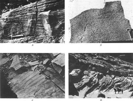
| FIGURE 22.—Primary structures in stratified rocks of Grand Canyon. A, Wedge-planar cross-strata in middle part of Callville Limestone, Grand Gulch mine trail. B, Interference ripple marks in fine-grained sandstone of Bright Angel Shale, Pipe Creek Canyon. C, Eolian-type ripple marks on steeply dipping cross-strata in Coconino Sandstone, Kaibab trail. D, Large-scale, tabular-planar cross-strata in middle cliff of Supai Formation, Havasu Canyon. |
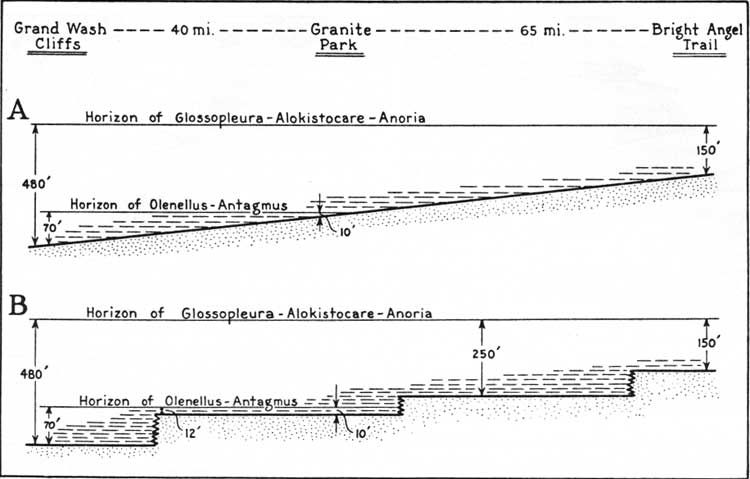
The Cambrian rocks of Grand Canyon offer one of the best documented illustrations of the mechanics of transgression (McKee and Resser, 1945, p. 133-138). Evidence is available both from the Tapeats Sandstone and from the Muav Limestone. Continuously exposed rock surfaces across wide areas and the presence of thin marker beds approximating time planes show that transgression consisted of a series of rapid advances, with pauses of considerable duration between each advance. During pauses, the sea floor was relatively stable, and little sediment could accumulate because of high base level, as shown in figure 23. Thus, periodic, rather than continuous, advance of the sea occurred.
|
| FIGURE 23.—Reconstruction of boundary between coarse sand and shale developed during transgression of the Cambrian sea. A. Based on field data only. B. Based on field data plus various theoretical considerations. From McKee and Resser (1945, fig. 12). (click on image for an enlargement in a new window) |
Detrital sedimentary rocks of the Cambrian, especially the coarse-grained sandstones, lend themselves well to statistical studies of texture and structure. Analyses show that the trough-type crossbedding, which consists of successive, superimposed channels, each filled either symmetrically or asymmetrically with dipping foresets, is very common, but that medium-scale tabular-planar and wedge-planar crossbeds also are present (fig. 20D). (Terminology for crossbeds according to McKee and Weir (1953).) Directional studies of cross lamination indicate a regional current trend from east to west. In some local areas, islands of Precambrian quartzite served to deflect the currents (McKee and Resser, 1945, p. 125-131), and directions of dip on crossbeds are very different in such places. Studies of degrees of sorting, skewness, and other properties of the sand grains have permitted reasonable speculations on depth of water, rate of sand accumulation, and other environmental considerations in reconstructing the history of the Tapeats Sandstone.
The Redwall Limestone of Mississippian age has recently been the subject of monographic treatment (McKee and Gutschick, 1969). The sedimentology was given careful consideration, along with stratigraphy, paleontology, and other aspects of the formation. Carbonate rocks that form most of the Redwall were found to be remarkably free of all detrital materials, but bedded chert constitutes a significant part of two of the four members. Dolomite, which forms a considerable part of the carbonate rock, is largely restricted to the lower part of the formation and is mostly in the relatively thin sections of eastern Grand Canyon. This, with other evidence, supports the concept that the dolomite was formed by normal diagenesis on the sea floor at an early stage after deposition.
Limestone of the Redwall includes both granular and aphanitic types, and these types alternate in a cyclic arrangement within the upper two members of the formation across a wide area. Although grain size of clastic carbonate particles may bear no relation to depth or distance from shore, studies of the Redwall suggest that cycles in this formation, recognized by differences in grain size, probably resulted from systematic changes in water depth that effected differences in wave base (McKee, 1960a, p. 231). The granular limestone of the Redwall includes three principal varieties that can readily be recognized: peloidal, skeletal, and oolitic. These varieties commonly occur in separate beds, but mixtures of two or all of them are not uncommon.
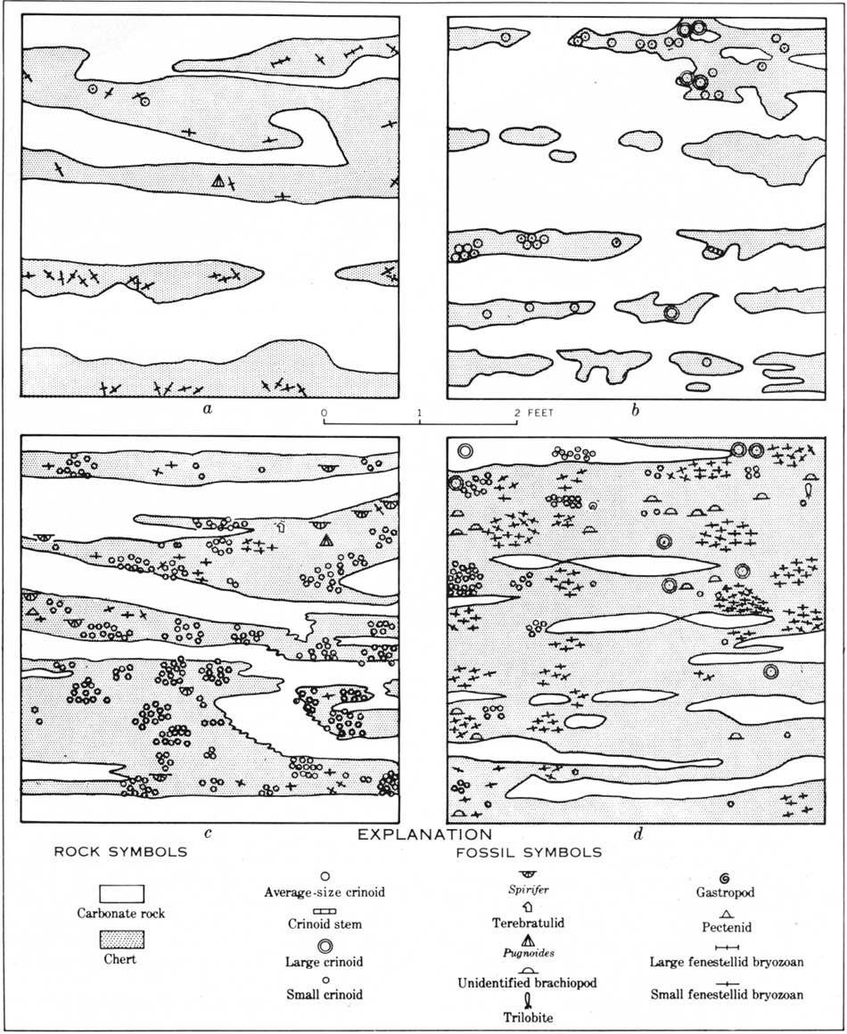
A semiquantitative study of bedded chert in the Thunder Springs Member (fig. 14G) of the Redwall was made at selected localities throughout the Grand Canyon region to determine relations and distributional trends of rock types and of fossils (McKee, 1960b). Through the analysis of a series of sample plots, a few of which are shown in figure 24, the probable time of chert development, on or beneath the sea floor, was determined to have been at a very early stage of diagenesis and before the associated calcium carbonate of the eastern Grand Canyon had been changed to dolomite. Furthermore, it was shown that types and relative abundance of animals in the Redwall sea differed according to paleogeographic location and (or) type of associated sediment.
|
| FIGURE 24.—Sample plots from four vertical outcrop faces of the Thunder Springs Member of the Redwall Limestone in Arizona, showing distribution of chert, carbonate rock, and associated fossils. From McKee (1960b, fig. 210.1). (click on image for an enlargement in a new window) |
An attempt has been made to determine the degree of turbulence (energy potential) represented by various parts of the Redwall (McKee and Gutschick, 1969, chap. 14. The principal evidence used in these determinations is the size and character of clastic grains in the carbonate rock, although the attitude and condition of included fossils locally also contributed evidence. In general, the aphanitic limestones, believed to have originated as lime muds, were most probably accumulated in quiet-water environments. Oolitic limestones are considered to represent environments of moderate energy potential—agitated, warm, and very shallow waters; peloidal limestones probably originated in waters of moderate to strong turbulence; skeletal or bioclastic limestones, in general, represent deposits from wave or current agitation of considerable magnitude, at least as compared with the energy conditions of other facies in the Redwall.
Sedimentology of the Supai Formation and overlying Hermit Shale has been much neglected until recent times, probably because, as in most red-bed formations, distinctive traceable rock units and widespread recognizable fossil zones are scarce. This paucity of dependable criteria for correlation has made difficult the determination of regional trends in the properties of sediments and in the distribution of contemporaneous facies. Before the 1960's, contributions to the depositional history of these red beds, therefore, had consisted only of a series of measured sections and a general description of texture, crossbedding, and other sedimentary features by Noble (1922, p. 60) and of a classic report on the flora of the Hermit Shale by David White (1929), in which the significance of mudcracks, salt molds, rain pits, and other sedimentary structures is discussed.
Recent sedimentologic work on the Supai and Hermit, largely by the writer and associates (unpub. data), has consisted of gathering data on thickness, lithofacies, textural properties, calcium-magnesium ratios, and current-direction data for various rock units. The usefulness of these data has depended on successfully working out a stratigraphic framework within which they could be plotted. A series of maps has been prepared, using material from measured sections that are distributed geographically as a net covering the Grand Canyon area and that are divided into five stratigraphic or vertical units within the red-bed sequence.
Current-vector maps based on average directions of crossbedding dips were made for the Supai (fig. 20C, fig. 22D) and correlatives (fig. 22A) as long ago as 1940 (McKee, 1940), although at that time most of the stratigraphic divisions of the Supai were not recognized, and results were therefore rather generalized. A southerly direction of sediment transport, determined at that time, has been substantiated by subsequent more detailed studies, made throughout a wide area and for each subdivision of the Supai. Further support for the concept of current movement in that direction has been provided through the compilation of maps showing grain-size distribution. Maximum grain sizes, dominant size grade, and percentage of grains greater than fine-grained all indicate a source to the north. Studies of calcium/magnesium ratios indicate that a marine environment lay both to the west and south.
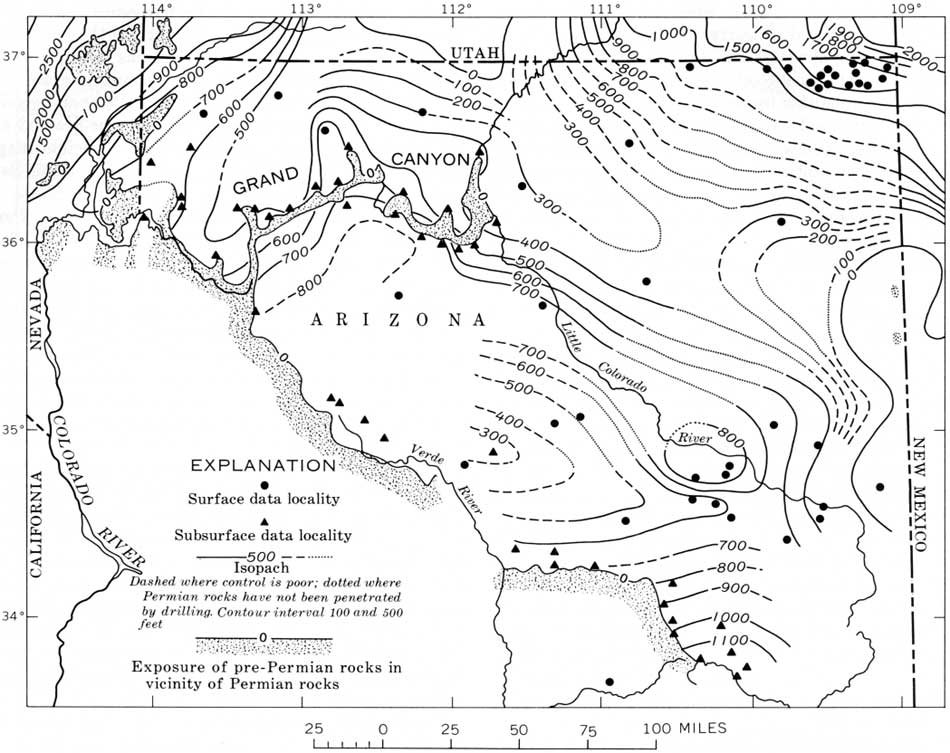
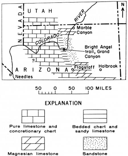
Isopach and lithofacies maps for the upper or Permian part of the Supai-Hermit sequence (McKee, Oriel, and others, 1967, pls. 3A, 3B) show two lobes of minimum thickness extending southward into northern Arizona from southwestern Utah; they are composed largely of sandstone and mudstone but include increasing percentages of limestone westward. Maps of corresponding areas for various parts of Pennsylvanian time (lower part of Supai) show somewhat similar patterns, as illustrated, in part, by a total Pennsylvanian isopach map (fig. 25).
|
| FIGURE 25.—Isopach map of northern Arizona for the Pennsylvanian System. (click on image for an enlargement in a new window) |
As a result of studies cited above, the Supai Formation is currently interpreted as a deltaic deposit. Evidence includes the lobate form of the deposit, its alternating sandstone and mudstone deposits that tongue into limestone in two directions, the character of its flora and fauna, and the types of sedimentary structures included. It apparently was built up by rivers that flowed southward from southern Utah, and it merged into marine deposits to the west and south. Its total development involved at least four phases within Pennsylvanian and Permian time.
The Coconino Sandstone is, perhaps, best known in the field of sedimentology because of its use during a pioneer study of current-vector analysis. Reconstruction of current orientation through determination of average dip directions of cross-lamination in the Coconino was made by Reiche (1938) in the Grand Canyon region and has served as a model for statistical studies of this type. Previous considerations of the Coconino—its petrography, minor sedimentary structures (fig. 22C), geometry of the sand body, and geomorphic features—had already indicated (McKee, 1933, p. 113) a probable eolian origin of the formation. Later, experiments on the forming of reptilian tracks in loose sand and comparison of these tracks with footprints in the Coconino, probably eliminated all reasonable doubt concerning the genesis of the Coconino as a desert dune deposit (McKee, 1944). Additional evidence of eolian origin based on sedimentary structures (fig. 20A) was recorded by McKee (1945).
The Toroweap Formation and Kaibab Limestone have not yet been studied using modern techniques and methods of carbonate-rock analysis, but the rock units of which these formations are composed were classified and described as lithologic facies (McKee, 1938) at a time when the concept of facies was still not widely understood in the United States. Interpretation of the environments represented by these facies was based on composition, texture, structure, fauna, and paleogeographic considerations; continental, marine, and intermediate environments were recognized.
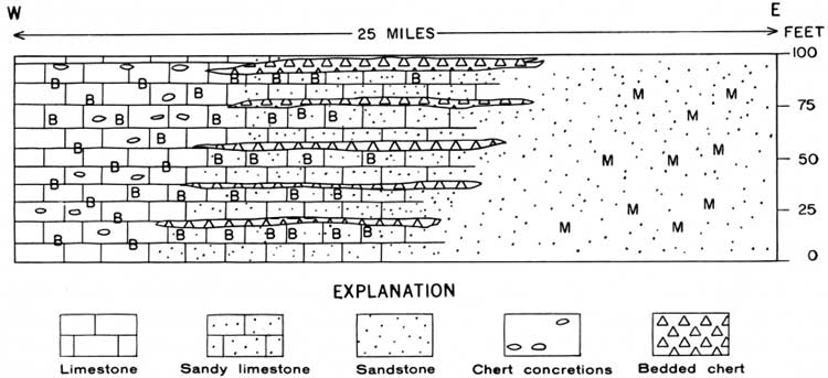
A sedimentologic feature of the Kaibab that has been given considerable attention and is significant in the history of this formation is the genesis of the bedded chert (McKee and Breed, 1969). Evidence that the chert beds (fig. 14F) were formed by silica introduced by rivers from the land and deposited by inorganic processes in an area where fresh and marine waters mingled is furnished by (1) the gradation from clean sand into pure calcium carbonate within the belt of bedded chert deposits, (2) a complete change in fauna from near-shore molluscan on the east to normal marine brachiopod-bryozoan-echinoid on the west, and (3) the cyclic occurrence of the chert (figs. 26, 27).
|
| FIGURE 26.—Facies distribution in middle member of Kaibab Limestone, Arizona and Utah. From McKee (1964, fig. 3). |
|
| FIGURE 27.—Schematic cross section of part of middle member of Kaibab Limestone near eastern end of Grand Canyon. B indicates brachiopod fauna, and M indicates molluscan fauna. From McKee (1964, fig. 2). (click on image for an enlargement in a new window) |
Both the Kaibab and the Toroweap are cyclic in character (McKee, 1964, p. 284). Each formation includes sediments of transgression, followed by those of regression; these formations consist of three vertical lithic divisions or members that have been characterized as deposits of an advancing sea, deposits of the most extended sea, and deposits of a receding sea (McKee, 1938, p. 35). Furthermore, within the regressive units (upper members) of each formation, cyclic sequences of smaller magnitude are recognized. Each of these sequences consists of a succession of beds of red sandstone, aphanitic limestone, and gypsum, from the bottom up (fig. 14E); this succession is interpreted as the result of a period of detrital accumulation followed by evaporite precipitation.
| <<< Previous | <<< Contents >>> | Next >>> |
pp/669/secb6d.htm
Last Updated: 22-Jun-2006