
|
Geological Survey Professional Paper 669
The Colorado River Region and John Wesley Powell |
RECENT STUDIES (SINCE 1935) AND THEIR INTERPRETATION
(continued)
Significance Of Unconformities
Because strata in the walls of Grand Canyon are not concealed, either by debris or by vegetation for long distances, buried erosion surfaces of various types and magnitudes appear as prominent features. A realization that these erosion surfaces may be the time equivalents of great numbers of strata elsewhere in the geologic column makes their importance in the region's history apparent.
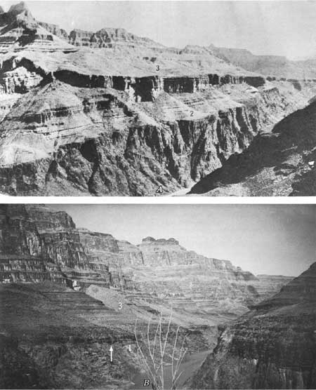
The most obvious and also the most significant of unconformities seen in the walls of Grand Canyon are those at the base of the Grand Canyon Series of late Precambrian age (fig. 19A) and at the bottom of the Tonto Group of Cambrian age (figs. 14D, 19A, and 19B). These unconformities were discussed by Powell (1875, p. 212), who pointed out that each represents a sequence of events of tremendous importance in earth history, including the formation of mountains by tectonic forces, the erosion of these mountains to a condition of base level, and, finally, the burial of the erosion surfaces by sediments of advancing seas.
|
| FIGURE 19.—Major unconformities in Grand Canyon involving (1) Vishnu Schist (includes granite), (2) Grand Canyon Series, (3) Tonto Group, Cambrian. A, Unconformities between lower and upper Precambrian rocks and between upper Precambrian and Paleozoic rocks near Shinumo Canyon opposite Bass trail. From Noble (1914, pl. 8B). B, Unconformity between lower Precambrian rocks and Paleozoic strata west of Quartermaster Canyon. |
Various aspects of these great unconformities have subsequently been examined and studied by many geologists, including Walcott, Noble, Hinds, Sharp, and McKee. The terms "Ep-Archean" and "Ep-Algonkian" were used by Hinds (1935, p. 4) in order to facilitate reference to each unconformity, and this procedure was subsequently followed in discussions by Sharp (1940) and by McKee (McKee and Resser, 1945). Principal features considered during investigation of the unconformities were the amount of relief on the erosion surfaces, the relative importance of marine as opposed to subaerial erosion, the duration of each period of erosion, and the climatic implications for each interval.
Probably the most conspicuous feature of the earlier or "Ep-Archean" erosion surface is its extreme flatness; it has relief not exceeding 20 feet in most areas and an observed maximum of 50 feet (Hinds, 1935, p. 10). In contrast, the "Ep-Algonkian" surface, although also referred to as a peneplain by some authors (Hinds, 1935, p. 49; Sharp, 1940, p. 1244), consists of a series of block-faulted quartzite ridges, some of which rise 800 and 900 feet above the general base of erosion (McKee and Resser, 1945, p. 117).
A weathered mantle from subaerial erosion is typical of both the "Ep-Archean" and "Ep-Algonkian" surfaces. Although only slight chemical weathering (on the "Ep-Archean" surface) was reported by Noble (1910, p. 524; 1914, p. 81) and a dominance of mechanical disintegration for both surfaces was suggested by Hinds (1935, p. 50), a depth of weathering of 10 feet beneath the "Ep-Archean" surface and as much as 50 feet beneath the "Ep-Algonkian" surface is recorded by Sharp (1940, p. 1264). The thesis of intense chemical weathering proposed by Sharp (1940, p. 1255-1257) is supported by his studies of the progressive changes of certain minerals such as biotite and feldspar, on evidence of residual concentrations of iron oxide, and on measurements of insoluble-residue accumulations.
Marine erosion undoubtedly took part in shaping the ultimate landscape that was covered by transgressing seas during both late Precambrian and Cambrian times. Examples of its effects on quartzite islands, forming sea cliffs and other characteristic features (fig. 20B), and of its reworking of weathered material and of talus have been cited by Noble (1914, p. 62), Sharp (1940, p. 1265), and McKee (McKee and Resser, 1945, p. 120). Sharp (1940, p. 1265) contends, however, that these "marine processes have modified the topography of the surfaces only to a minor degree."
|
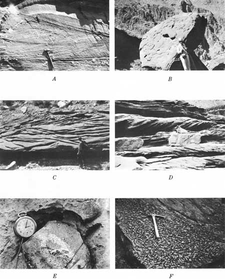
| FIGURE 20.—Fossils and sedimentary features in stratified rocks of Grand Canyon. A, Wedge-planar cross-strata of Coconino Sandstone near Bright Angel trail. B, Boulder of upper Precambrian Shinumo Quartzite incorporated in fallen block of Cambrian Tapeats Sandstone, near south Kaibab trail. C, Trough-type cross-strata in upper part of Supai Formation, along Topocoba trail. D, Tabular-planar cross-strata in Tapeats Sandstone at Forster Canyon. E, Siliceous sponge, Actinocoelia, forming nucleus of spherical chert concretion, Kaibab Limestone, Hermit trail. F, Probable worm borings in upper part of Tapeats Sandstone near Grand Wash Cliffs. |
The periods of time represented by the two great unconformities in Grand Canyon must have been of great duration, as indicated by the record of events that these unconformities portray. The tremendous amount of time represented by the "Ep-Algonkian" unconformity so impressed Walcott (1910, p. 14) that he assigned it a name—the Lipalian interval—and he described it as "an era of unknown marine sedimentation between the adjustment of pelagic life to littoral conditions and the appearance of the Lower Cambrian fauna." The magnitude of this break in the record was later minimized by Hinds (1939, p. 306), who argued that Lipalian time was not one of long-continued emergence and that a great break in the record did not separate latest Precambrian from Cambrian time. On the other hand, calculations of the time involved in lowering by erosion a land surface of the height represented by the upper Precambrian strata of Grand Canyon were made by Sharp (1940, p. 1260-1261), who concluded that roughly 100 million years would have been required.
Other conclusions based on studies of the great unconformities have involved speculations on the climate during late stages of erosion and immediately preceding marine deposition after each hiatus. Despite earlier contentions to the contrary, a strong case was made by Sharp (1940, p. 1255) to indicate that in both "Ep-Archean" and "Ep-Algonkian" times dominantly humid conditions prevailed. The evidence included considerations of insoluble residues, nature and extent of weathering, lack of caliche, content of iron oxide in detritus, and type of residual feldspar.
Two relatively minor yet locally significant unconformities have been recorded from within the upper Precambrian strata of the Grand Canyon (Van Gundy, 1951, p. 954-955). On the basis of these two stratigraphic breaks, the Nankoweap Group of Van Gundy (1934) was separated from the Unkar and Chuar Groups. The earlier of the unconformities is described as being formed on top of basaltic lava flows of the Unkar which were eroded to an irregular surface and, in many places, covered by a conglomerate of basalt and sandstone debris. The later unconformity likewise is marked by an erosion surface and a conglomerate, and it underlies magnesian limestone of the Chuar.
Compared with the two great unconformities formed during and at the close of Precambrian time, others that have left their records in the walls of Grand Canyon are small. Nevertheless, the significance of various later erosion intervals, in terms of time involved if not of total volume of rock removed, is considerable. Most notable of these time breaks are the pre-Devonian, pre-Pennsylvanian, and pre-Triassic unconformities. More difficult to recognize, but nevertheless of significance because of the hiatus involved, are unconformities underlying rocks of the Mississippian and Permian Systems of this area.
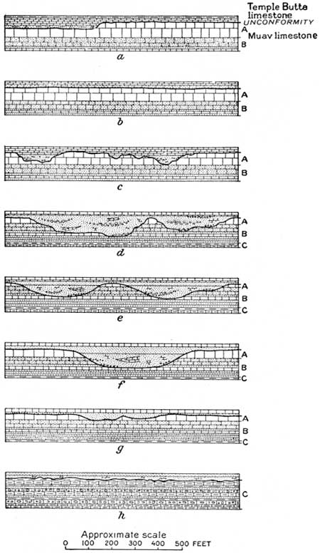
An unconformity involving a hiatus of considerable magnitude—Late Cambrian, Ordovician, Silurian, and Early and Middle Devonian time—has been recognized at the top of the Cambrian sequence of the Grand Canyon. This break in the record is marked by a surface of erosion that in places consists of relatively narrow channels, as much as 100 feet or more deep, that were subsequently filled with sediment of Late Devonian age (fig. 14B). Such erosional irregularities were noted first by Walcott (1880, p. 221; 1883, p. 438); a detailed description of them, accompanied by sketches (fig. 21), as found along a 28-mile stretch of Grand Canyon walls, was subsequently given by Noble (1922, p. 49-51). Since then, few new data concerning the nature of this erosion surface have been obtained, but observations by the writer indicate that channels similar to those described also occur locally beneath thick Devonian sections in western Grand Canyon. Where no channels occur, the boundary between strat of Cambrian and Devonian age (Mississippian in parts of eastern Grand Canyon), commonly is difficult to recognize.
|
| FIGURE 21.—"Diagrammatic sketches showing general character of unconformity between Temple Butte limestone and Muav limestone at eight localities between Garnet Canyon and Cottonwood Creek, Grand Canyon, Ariz. a, Garnet Canyon; b, Bass Canyon; c, Ruby Canyon; d, Turquise Canyon; e, Slate Creek; f, Hermit Creek; g, Pipe Creek; h, Cottonwood Creek." From Noble (1922, fig. 3). |
A pre-Mississippian unconformity is represented by a flat, even surface between dolomite units of Devonian (locally Cambrian) age and Mississippian age in eastern Grand Canyon (Noble, 1922, p. 53), but in many places it is obscure. Farther west, the unconformity is marked by a surface of slight relief and local conglomerates, so in places it is more readily located but is still not conspicuous (McKee and Gutschick, 1969, chap. 2). Nowhere is there evidence of large uplift that would cause marked dissection of the region or form angular unconformable relations between formations; beveling of the surface across a wide area, however, may have taken place. Faunal evidence suggests that a hiatus occurred, involving all of Kinderhook time in the east and much of it in western Grand Canyon (McKee and Gutschick, 1969). The later part of Late Devonian time may also be unrepresented in rocks of this region, though evidence is scant (Poole and others, 1967, p. 887).
Between the Redwall Limestone of Mississippian age and the Supai Formation of Pennsylvanian age is an unconformity which, though scarcely noticeable in most places along the walls of Grand Canyon, is, nevertheless, an excellent record of erosion by solution. A rugged, irregular karst surface with local relief ranging from 3 to 40 feet forms the top of the Redwall (McKee and Gutschick, 1969). Depressions on this surface include channels of through-flowing streams, indicated by well-rounded cobbles and pebbles of chert and other durable materials that partially fill them; also included are ancient sinkholes, many of which contain angular fragments of locally derived limestone or dolomite. Elevations on the erosion surface consist of flat-topped ridges and low mesas or buttes that have been surrounded and buried by blankets of red mud and, in some places, by initial deposits of thin-bedded calcium carbonate of the Supai Formation. In many other places, caverns and solution-enlarged shrinkage cracks, partly filled with red mud of the Supai, extend down into the Redwall.
The hiatus represented by the unconformity at the top of the Redwall is between rocks of Meramec age (probably Osage in eastern Grand Canyon) and those of Morrow age—well above the base of the Pennsylvanian System. One exception is along the Bright Angel trail where a remnant of Chester-age rocks caps the Redwall (McKee and Gutschick, 1969). In the Grand Canyon area, no appreciable reduction of the original thickness of the Redwall occurred during pre-Supai erosion, for only the thin upper member is affected.
Probably the least well known of the important unconformities in the Grand Canyon sequence of stratified rocks is that between the Pennsylvanian and Permian age rocks. This stratigraphic break is marked by an overlying conglomerate of rounded gravel, composed largely of limestone, siltstone, and sandstone that seem to be locally derived. The conglomerate commonly has been considered intraformational, but detailed studies by the writer (unpub. data) show that it is persistent and extends from one end of Grand Canyon to the other. It is a gravel sheet that thins and thickens within short distances and is absent locally; it rests on an undulatory, channeled surface which in places has been eroded to form depressions 30 or 35 feet deep. In western Grand Canyon this excellent marker bed lies between marine units containing fossils that indicate Virgil (Late Pennsylvanian) age below and Wolfcamp (Early Permian) above.
The top of the Kaibab Limestone, which forms the rim of Grand Canyon, is in the approximate position of the Permian-Triassic unconformity, although in only a few places on the rim do overlying Triassic rocks remain to preserve the ancient erosion surface. This unconformity has been the subject of many detailed studies: Dake (1920); Longwell (1925); Baker, Dobbin, McKnight, and Reeside (1927); and McKee (1938, p. 55-61; 1954).
The hiatus represented by the break between the Kaibab Limestone and the Moenkopi Formation involves the time between the Leonard or early part of the Permian and the middle stage (Meekoceras zone) of the Early Triassic. It is calculated, therefore, in terms of some tens of millions of years. Physical evidence of the unconformity consists of irregular surfaces of erosion, of basal conglomerates, and, in some areas, of angular discordance. The most conspicuous record of vigorous erosion is in southwestern Utah and southern Nevada, where narrow valleys or canyons, 100 to 700 feet deep and partly filled with large pebbles and boulders, are reported (Longwell, 1921, p. 49; Reeside and Bassler, 1922, p. 60). In contrast, in the region east and north of the Grand Canyon, Ariz., the surface is generally flat and even, and pebbles in the basal conglomerate are small and subangular.
Interpretations of the pre-Moenkopi erosion surface differ materially. This surface has been attributed both to marine planation (Dane, 1935, p. 52-53) and to subaerial channeling by stream floods (Longwell, 1925, p. 106). The large channels, at least, seem to have been cut and largely filled by locally derived gravels before the first marine deposits were laid down.
| <<< Previous | <<< Contents >>> | Next >>> |
pp/669/secb6c.htm
Last Updated: 22-Jun-2006