
|
Geological Survey Professional Paper 669
The Colorado River Region and John Wesley Powell |
RECENT STUDIES (SINCE 1935) AND THEIR INTERPRETATION
(continued)
Paleogeography And Paleotectonics
Many attempts have been made within recent years to reconstruct the geographic and tectonic features of various ages in the Grand Canyon region. Paleogeographic maps prepared by Stoyanow (1942, pl. 5) illustrate his views, largely derived from the study of invertebrate fossils, on the distribution of land and sea within Arizona during various parts of the Paleozoic. A series of isopach maps of the Paleozoic rocks of Arizona and adjoining areas was published in 1951 (McKee, 1951). More elaborate and detailed maps, both isopach and lithofacies, but only for certain Paleozoic systems, have since been prepared as parts of the paleotectonic map series of the U.S. Geological Survey (for example, the Permian System: McKee, Oriel, and others, 1967; also maps for Pennsylvanian and Mississippian Systems, unpub. data). These maps include Arizona. Finally, a detailed isopach map of Mississippian rocks of the Grand Canyon area, and one for each of the Redwall members, have been published by McKee and Gutschick (1969, figs. 2, 7, 16, 23, 28).
Information on paleogeography of upper Precambrian stratified rocks in Grand Canyon is meager, partly because reliable data on precise correlation with rocks of adjoining areas are lacking. Trends in lithofacies, especially the considerable increase westward in percentage of carbonate rock within the Bass Limestone and the greater proportion of sand in the Hakatai Shale of eastern Grand Canyon than farther west were pointed out by Noble (1914, p. 54). Van Gundy (1951) obtained a small amount of information on directional movements of currents for the Nankoweap Group of Van Gundy (1934) and for the Chuar Group (Trevor Ford and W. J. Breed, unpub. data). By and large, however, the location and distribution of geographic and tectonic trends and their relationship to trends that dominated the history of Paleozoic time are not yet known.
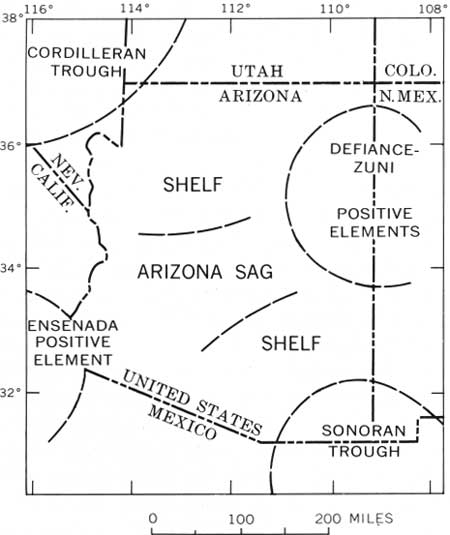
Analysis of various maps, and accompanying texts, of the Grand Canyon region for Paleozoic time shows that the early concept of a landmass, referred to as Mazatzal Land, separating basins of northern and southern Arizona, does not satisfy the test of isopach mapping. The geographic picture that has evolved (fig. 18) and that seems to be rather similar for all Paleozoic systems is that of two positive elements—the Defiance (or Defiance-Zuni) in northeastern Arizona and the Ensenada southwest of Arizona—and seas from the Cordilleran and Sonoran troughs to the northwest and southeast, respectively, advancing periodically across adjacent shelves to connect across the Arizona sag of Eardley (1949, fig. 2) in central Arizona. Some doubt exists concerning the validity of the Ensenada positive area, because the record of Paleozoic rocks is poor in southwestern Arizona (McKee, 1947); thickness trends, however, suggest a definite and considerable thinning toward that corner of the State.
|
| FIGURE 18.—Structural features of Arizona during middle part of Permian Period. Adapted from McKee and Breed (1969, fig. 2). |
| <<< Previous | <<< Contents >>> | Next >>> |
pp/669/secb6b.htm
Last Updated: 22-Jun-2006