
|
Geological Survey Professional Paper 669
The Colorado River Region and John Wesley Powell |
INTRODUCTION
The Problem
The Colorado River is the river of John Wesley Powell. Not only was he the first to explore and chart the canyons of the Green and the Colorado from Wyoming to the foot of the Grand Canyon, he was first to attempt to explain how they formed. On the basis of their geologic history, Powell distinguished three kinds of valleys in the river system. One type he named consequent (Powell, 1875, p. 163); these valleys have courses directly inherited from a bedrock surface formed by folding, tilting, or other type of earth movement. The axis of a newly formed downfold, or syncline, becomes a stream course; the axis of a newly formed upfold, or anticline, becomes a drainage divide. The radial drainage off the volcanic pile and uplift in the San Juan Mountains in southwestern Colorado (figs. 28, 29) is consequent drainage.
|
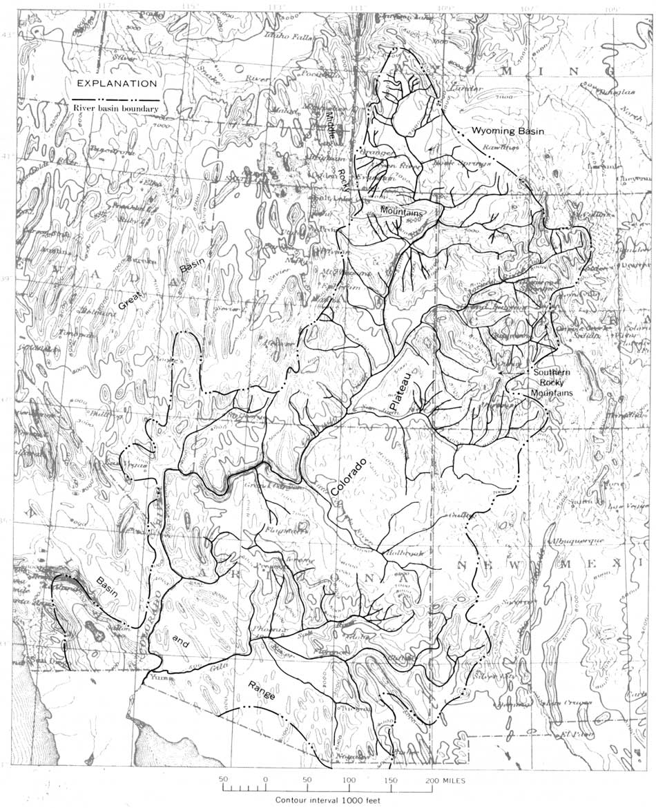
| FIGURE 28.—The Colorado River, 1,440 miles long, has a drainage basin of almost 250,000 square miles in five plysiographic provinces. In the Southern Rocky Mountains, where the river begins, extensive areas are higher than 10,000 feet in altitude, and peaks are above 14,000 feet. Most of the Colorado Plateau is about 5,000-7,000 feet in altitude, and the river crosses this plateau in deep canyons, culminating in the Grand Canyon. In the Basin and Range province the river is below 2,000 feet; few of the mountains near the Colorado River are as high as 5,000 feet. (click on image for an enlargement in a new window) |
|
|
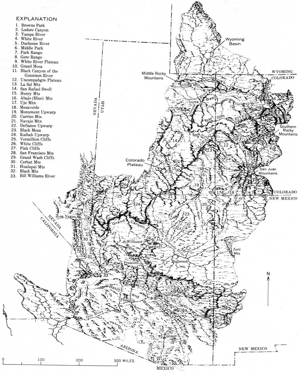
FIGURE 29.—Colorado River drainage basin, showing
the principal landforms that distinguish the plysiographic provinces
crossed by the river and its tributaries. In the interior of the Wyoming basin, relief along the Green River is only a couple of hundred feet, and in places the valley bottom is wide. Where the resistant formations form escarpments at the turned-up edges of the basin, the relief is as great as 1,000 feet. Because this is a structural basin, the escarpments face outward. In the Middle and Southern Rocky Mountains, the rivers are in steep-sided valleys 2,000 or 3,000 feet deep where they cross the mountain barriers; there are some small flood plains in the open valleys upstream from these barriers. Escarpments face the mountains, which are uplifts. On the Colorado Plateau, the rivers characteristically are in canyons cut into very colorful rock formations. Grand Canyon cuts across the high southwest rim of the plateau, which probably still is being uplifted. Broad open valleys like those in the Wyoming Basin occur on the Colorado Plateau in the Uinta basin and along the San Juan and Little Colorado Rivers. In the Basin and Range province, the Colorado River flows west across the north-trending structural barriers and then turns 90° south and parallels them. Flood plains are extensive along this part of the river. (click on image for an enlargement in a new window) |
Most of the Colorado River drainage system, though, is not consequent, and Powell distinguished two principal kinds of nonconsequent valleys. One that he called antecedent (Powell, 1875, p. 163), persists on a land surface where folds or other displacements form after a consequent drainage system has been formed. Unless the folds or other displacements are produced rapidly, the drainage lines are not diverted, and the streams cut downward vertically as the uplifts are raised athwart their courses.
A second kind of nonconsequent valley Powell called superimposed (Powell, 1875, p. 166). This type of valley is formed where previously folded or tilted rocks are buried by younger unconformable sediments on which a consequent drainage then forms. This drainage cuts vertically downward into the buried structures and becomes incised into them.
Powell concluded (1875, p. 166) that the valleys crossing the Uinta Range were antecedent.
Powell's brilliant protégé, G. K. Gilbert, elaborated on Powell's ideas by noting that drainage may become superimposed in several ways (Gilbert, 1877, p. 144):
1. From marine deposits that bury old structures and then become elevated and dissected.
2. From alluvial or other terrestrial deposits that bury old structures and then become dissected.
3. From erosion surfaces truncating older structures. Gilbert also pointed out that the instability of divides will cause changes in the manner of superposition as downcutting progresses.
Gilbert noted (1877, p. 139-142) that a stream or system of streams belonging to one drainage system may become diverted to another system by ponding or by deposition of alluvium. In like manner, the shifting of a stream from one system to another may be caused by lateral planation and lateral extension of a flood plain that cuts through a divide, enabling the stream to spill into a neighboring, lower drainage system. Finally, he noted that where strata are inclined, the divides, which are at the brows of the cliffs, retreat as the cliff faces are sapped by erosion. The Pink Cliffs, formed by the southern edge of the Tertiary formations in the High Plateaus in southwestern Utah (fig. 29), are an example. The cliffs face south; the plateau back of them slopes north. As the cliffs retreat northward, the divide between the Colorado River and the drainage to the Great Basin retreats northward. This kind of shift in divide he referred to as monoclinal shifting (Gilbert, 1877, p. 140).
Gilbert also gave us the first clear description of the process we know today as stream capture. He wrote (1877, p. 141):
A stream which for any reason is able to corrade its bottom more rapidly than do its neighbors, expands its valley at their expense, and eventually "abstracts" them. And conversely, a stream which for any reason is able to corrade its bottom less rapidly than its neighbor, has its valley contracted by their encroachments and is eventually "abstracted" by one or the other.
The problems of Colorado River history remain today very much as Gilbert described them almost 100 years ago (1876, p. 101), "What is the relation of the drainage system * * * to the system of displacements? How far is it consequent, how far antecedent, how far super-imposed?" Too, how much is due to a combination of those processes or anteposition (Hunt, 1956, p. 65-66), how much is due to capture (for example Bradley, 1936, p. 189), and how much is due to integration resulting from ponding at and overflow of basins as they become filled? All these processes seem to have operated at one place or another.
The question, "How old is the Colorado River?" is oversimplified to the point of being misleading. The structural barriers crossed by the river and its tributaries are of different ages, and most of them involve late Tertiary as well as early Tertiary movements. The canyons through the barriers are of different ages and are the result of different kinds and different combinations of processes. The Colorado River has been evolving ever since the uplift of the Rocky Mountains began (or was resumed) at the end of the Cretaceous period (about 65 million years ago). Some valleys in the river system are as old as Oligocene (40-25 million years ago); other valleys are Quaternary, the last 2 or 3 million years. Not all of the Grand Canyon may be of the same age. If the river once discharged from the Colorado Plateau at Peach Springs (Hunt, 1956, p. 30) (figs. 48, 53), the headward part of the Grand Canyon could be very much older than the lower stretches in lower Granite Gorge. Questions about the age and processes of origin must be asked about each part of the river separately, all the way from the headwaters to the mouth.
Other factors besides structure that bear on the geologic history of the river are touched on but lightly in this report. Among these factors are: development of the meander patterns; sculpture of the mountains, plateaus, and canyons; episodes of accelerated weathering, accelerated erosion, and episodes of cut and fill along the river; comparative effects of climatic and of structural change; and changes in river regimen.
Setting
The Colorado River drainage system (figs. 28-31) extends into five physiographic provinces. Its headwaters are in the Southern and Middle Rocky Mountains and it crosses the Wyoming Basin, the Colorado Plateau, and the Basin and Range province. To reach the Gulf of California, the river and most of its tributaries must cross many mountains and high plateaus which are structural barriers of resistant rocks. No other river in the Western Hemisphere crosses so many. Not only does the river cross mountain barriers, it must also cross the Colorado Plateau, a tremendous structural block covering more than half the drainage basin; the plateau has been uplifted and tilted northeast against the river. Grand Canyon, where the Colorado River leaves the plateau, is cut across the highest part of the rim, the highest structurally and one of the highest topographically.
Most valleys in the drainage system are narrow and steep sided; broad alluvial flood plains are uncommon. There are a few small flood plains in the Rocky Mountains and on the Colorado Plateau upstream from some of the structural barriers, but the only extensive ones are in the Basin and Range province—near Needles, Calif., below the Bill Williams River, and along parts of the Gila River. Much of the river's 300-mile course across the Colorado Plateau is in rock-walled canyons, and the river meanders greatly, much more so than most rivers that are not on alluvial flood plains. Surely these meanderings record the difficulties of the river in maintaining its flow across rising folds and against the northeast tilt of the Colorado Plateau. The folding and tilting have continued as repeated, even though minor, movements, while the river has been cutting its canyons, and probably are still going on.
|
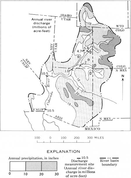
| FIGURE 30.—Average annual precipitation in the Colorado River drainage basin and average annual discharge of the river and of some of its principal tributaries. The annual discharge, usually 10-15 million acre feet, is almost entirely from the Southern and Middle Rocky Mountains. Very little runoff is contributed from the areas where precipitation averages less than 15 inches annually; almost all that water is lost by seepage, evaporation, and transpiration. This dependence on runoff from the Rocky Mountains probably has been true throughout the river's history. Annual runoff from the basin as a whole averages less than 1 inch. Sediment load, however, is one of the highest in the United States; at Grand Canyon this load is about twice the average of other rivers in the United States (load now trapped in Lake Powell) and represents an average lowering of about 6.5 inches per 1,000 years of the basin upstream from Grand Canyon. Most of the erosion is in the shale formations, especially the Cretaceous. |
|
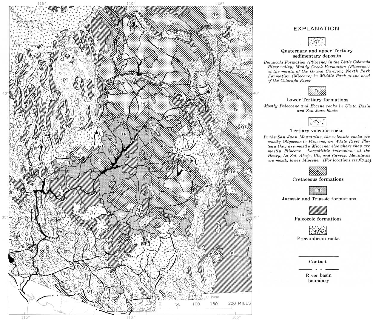
| FIGURE 31.—Colorado River basin (from Kinney, 1966). The upper part of the Colorado River system heads in the Middle and Southern Rocky Mountains which consist of uplifted Precambrian, Paleozoic, and Mesozoic rocks and in the mountains in southwestern Colorado (San Juan Mountains), a great pile of volcanic rocks. After leaving the Rocky Mountains, the rivers are in Tertiary formations in the north and eastern parts of the drainage basin, and then, flowing against the northeast dip of the Colorado Plateau, the rivers cross, in succession, Cretaceous, Jurassic, Triassic, Paleozoic, and Precambrian rocks. After leaving the Colorado Plateau at Grand Canyon, the Colorado enters the Basin and Range province, but even there the course is not confined to the basins but cuts through some of the mountain barriers. (click on image for an enlargement in a new window) |
Previous Work
Powell (1875) was first to attempt to explain the many anomalous features of the Colorado River system. He was vague about the age of the river, but according to his interpretation, the Green River is antecedent across the Uinta Mountains. We now know that this interpretation would require an ancient, Paleocene or Late Cretaceous, beginning for the river. Dutton (1882, p. 218-222) was the first to be definite about the age. He concluded that the Colorado River formed by middle Tertiary (Miocene) time as a result of integration, overflow, and drainage of the Eocene lakes. By his (Dutton, 1882, p. 224-226) interpretation, the river was antecedent across the rim of the Colorado Plateau and across the uplifts at Grand Canyon, and the canyon cutting occurred mostly during Miocene and Pliocene time. This seems to have been the history.
Later workers, especially Davis (1901) correctly pointed out that many of the drainage anomalies on the Colorado Plateau are better explained by superposition than by antecedence. Others have assumed capture as a major part of the process, and still others—I for one—have assumed combinations of the processes—anteposition (Hunt, 1956). The river's course, for example, may have been superimposed across an anticline, and then remained in a course antecedent to renewed uplift at the anticline. Table 1 briefly summarizes the principal interpretations about the process and age.
TABLE 1.—Principal interpretations of process and age for various parts of the Colorado River system
| Publication | Segment of river | Principal process | Age |
| Newberry (1861) | Colorado River below Grand Canyon. | Basin filling and overflow; a form of superposition. | ? |
| Powell (1875) | Green and Colorado Rivers | Antecedence | Not stated; would have to be Paleocene or older. |
| Gilbert (1876) | do | Consequence, antecedence, and superposition. | Not stated. |
| Dutton (1882) | Grand Canyon | Antecedence implied; by basin filling and overflow. | Early Tertiary but younger than the early Tertiary lakes. |
| Hayden (1862, 1873) | Rivers in Rocky Mountains | Antecedence | ? |
| Walcott (1890) | Marble Canyon | Antecedence; river closely adjusted to local structure during downcutting. | ? |
| Irving (1896) | Green River | Antecedence? | ? |
| Davis (1897) | Green River canyons in Uinta Mountains | Antecedence or superposition depending on what beds overlay the Uinta arch. | ? |
| Emmons (1897) | do | Not antecedence |
Late Tertiary. |
| Jefferson (1897) | Colorado River | At first consequence, then antecedence. | ? |
| Davis (1901) | do | Superposition | ? |
| Noble (1914) | Grand Canyon | Between Bright Angel and Kanab Creeks, river parallels northeast-dipping fissures. | ? |
| Hancock (1915) | Yampa River | Superposition | Late Tertiary |
| Longwell (1928) | Colorado River from Grand Canyon to Boulder Canyon. | do | Quaternary. |
| Sears (1924b) | Green and Yampa Rivers | do | Post-Browns Park Formation (that is, middle Pliocene and later). |
| Moore (1926a, b) | Colorado River on the Plateau | Meanders inherited; size depends on size of river. | Grand Canyon older than canyons upstream. |
| Blackwelder (1934) | Colorado River in Grand Wash and Grand Canyon. | Superposition or piracy as result of basins filling and overflowing. | Pleistocene. |
| Bradley (1936) | Lodore Canyon, Green River | Capture | Post-Browns Park Formation (that is, middle Pliocene and younger). |
| Longwell (1946) | Colorado River, Grand Canyon to Boulder Canyon | Superposition | Post-Hualapai Limestone (that is, late Pliocene and Pleistocene). |
| Gregory (1947) | Colorado River on the Colorado Plateau. | Superposition from a Miocene surface of erosion. | Late Tertiary. |
| Babenroth and Strahler (1945); Strahler (1948). | Grand Canyon in Kaibab uplift. | Original course could be antecedent; present course superposed from Triassic and adjusted to local structure. | ? |
| Childs (1948) | Grand Canyon | ? | Grand Canyon 2,000 ft deep when lavas reached Black Point 500 ft above Little Colorado River. |
| Hunt (1946); Hunt and others (1953) | Colorado River on the Colorado Plateau. | Integration by basin fill and overflow; river superposed across folds; antecedent across the plateau. | Early Tertiary but younger than early Tertiary lakes. |
| Hunt (1956) | Colorado River on the Colorado Plateau. | Anteposition across folds; antecedent across plateau. | Middle Miocene. |
| Sears (1962) | Yampa Canyon in Uinta Mountains. | Superposition | Post-Browns Park Formation (that is, middle Pliocene and later). |
| Longwell (1963) | Colorado River, Lake Mead to Davis Dam. | do | Post-Muddy Creek Formation (that is, middle Pliocene and later). |
| Cooley and Davidson (1963) | Grand Canyon | Not stated | Late Miocene and Pliocene. |
| Hansen (1965a) | Black Canyon of the Gunnison | Superposition | Younger than the Miocene lavas. |
| Lohman (1965) | Unaweep Canyon and course of Colorado River around Uncompahgre Plateau. | Capture | Late Pliocene. |
| Cater (1966) | do | do | Late Pliocene or Pleistocene. |
| McKee and others (1967) | Grand Canyon | Capture by headward erosion of streams draining off Colorado Plateau. | Late Pliocene and Pleistocene. |
| Metzger (1968) | Colorado River below Needles, Calif. | Superposition? following retreat of ancestral Gulf of California embayment. | Pliocene |
The great differences in ages that have been inferred for the Colorado River—from Eocene to Pleistocene (about 50 million years)—are more apparent than real, because the several authors have not been talking about the same sections of the river. The view that the Colorado is an ancient river considers the river as a whole from the time of the first uplift of the present Rocky Mountains; the view that the river is young is based on particular segments. Most authors have assumed only one process or mode of origin despite the fact that the processes are not mutually exclusive. Some parts of the river system surely are the result of one process, some parts equally surely are the result of another, and still other parts must be the result of several processes. Each part of the river system needs to be looked at separately.
Acknowledgments
The difficulties of interpreting the geologic history of a major river system, the vastness of the area and time to be considered, and the incompleteness of the evidence, leave plenty of room for different interpretations about many phases of the history of the Colorado River. Although a hypothesis for the historical development of the Colorado is offered here, a major purpose of this chapter is to provide a frame of reference into which isolated bits of new evidence can be fitted. If all the widely separated deposits in the river basin could be inventoried and reviewed, a reasonably satisfactory account of the river's history might be indicated; until this is done we must depend on hypothesis. The hypothesis presented in this chapter is summarized in table 2.
TABLE 2.—Geologic history of the Colorado River
[Tabular summary of the interpretation, much of it conjectural, presented in this paper, sequence within time intervals arranged with earliest event at bottom]
| Time interval and approximate age of boundaries (in millions of years) |
Geographic regions | |||
| Basin and Range province | Colorado Plateau | Rocky Mountains Colorado and Gunnison Rivers above Grand Junction | ||
| Southern section Below mouth of Green River |
Northern section Green and upper Colorado Rivers | |||
| 0 | ||||
| Quaternary | Colorado River canyon in Black Mountains deepened by renewed uplift (antecedence). | Grand Canyon of Colorado River deepened very little since mid-Pleistocene
time. River in Grand canyon within about 50 feet of present depth about 1.2 million years ago. Uplift and (or) northeast tilting of plateau probably continued intermittently throughout the Quaternary and probably is still continuing. |
Canyons of Green and Yampa Rivers deepened about 500 feet. | Main river valleys and canyons deepened about 500 feet in glacial
Pleistocene time; headwater stretches deepened 1,000-1,500 feet. Unaweep Canyon abandoned in late Pliocene or earliest Pleistocene time. |
| 2 | ||||
| Pliocene | Colorado River discharges to Hualapai Lake and it overflows westward
across Black Mountains. Limestone (Hualapai) deposited in fresh-water spring-fed lake centering at mouth of Colorado River canyon in Grand Wash Cliffs. Alluvial and playa beds (Muddy Creek Formation) deposited in Lake Mead area. Colorado River not there. Estuary along lower Colorado River (below The Needles) throughout much of Pliocene time. |
Colorado River discharges at mouth of Grand Canyon. Ancestral Colorado River joins the Little Colorado and San Juan Rivers; overflows through arched ancestral Grand Canyon. Uplift and northeast tilting of plateau probably continued intermittently throughout the Pliocene. Renewed uplift at Kaibab Plateau ponds ancestral Colorado and Little Colorado Rivers; begin deposition of Bidahochi Formation (earliest Pliocene). Ancestral drainage, ponded at Peach Springs, discharged at Grand Wash Cliffs as big springs fed by pipes enlarged in the now cavernous limestone formations dipping down axis of present lower Granite Gorge. |
Renewed uplift at Uinta Mountains (or downfaulting of adjoining basins)
deepens the canyons by perhaps 1,000 feet (antecedence). Green and Yampa Rivers super-imposed in southward courses across the Uinta Mountains, probably when the mountains were structurally lower relative to adjacent basins than now and were buried by Browns Park Formation. This superposition probably took place in early Pliocene lime, perhaps in the late Miocene. |
Canyons of the Colorado River through uplifted blocks such as the Gore
Range or White River Plateau deepened 2,000-3,000 feet during Pliocene
time (antecedence); Black Canyon of the Gunnison River. Colorado and Gunnison Rivers cross Uncompahgre Plateau and cut Unaweep Canyon. |
| 12 | ||||
| Miocene | Estuary along lower Colorado River (below The Needles); Colorado River
apparently flowed into it by way of canyon at Peach springs, Ariz. Accumulation of lavas, dated radiometrically at 16-17 million years old, in gap at Kingman, Ariz., between Hualapai and Cerbat Mountains; the gap may be segment of canyon at Peach Springs, Ariz., faulted off plateau. Deposition of alluvial and playa beds, lower part of Muddy Creek Formation(?), in Lake Mead area; most movement along faults near Grand Wash Cliffs by middle Miocene time. |
Canyon at Peach springs partly filled with deposits dated
radiometrically at about 18.3 million years old; renewed uplift at
Kaibab Plateau. Gravel deposits on Kaibito Plateau, derived in part from San Juan Mountains, indicate that by late Miocene time, San Juan River flowed across Monument upwarp to within 80 miles of Grand Canyon; probably crossed ancestral Kaibab uplift in canyon and joined ancestral Little Colorado River west of there. By middle Miocene time the Little Colorado River had course south of Kaibab upwarp and left plateau by way of canyon near Peach Springs, Ariz. Plateau uplifted and tilted northeastward intermittently throughout the Miocene. |
Doming of laccolithic mountains by intrusions about 25 million years ago
caused drainage to be diverted around mountains (La Sal, Ute, Henry,
Abajo, Navajo Mountains). White River follows a westward, essentially consequent course down axis of Uinta basin. Ancestral Green and Yampa Rivers discharge into Wyoming basin north of Uinta Mountains. Northern part of main Colorado River drainage is assumed to have ended in playas in Henry Mountains and (or) Kaiparowits basins. |
Present course of main stem of Colorado River largely established by
overflowing structural barriers by end of Miocene time; Gunnison River
superimposed across Precambrian rocks at Black Canyon. Headward part of Colorado River disrupted by formation of structural basins at head of Yampa River, near Stale Bridge, and in Middle Park; and by uplift of White River Plateau and Gore Range. Ancestral Colorado River continues consequent westward course to Uinta basin; continued outpouring of lava in Gunnison River valley. |
| 26 | ||||
| Oligocene | Breakup of highlands into basins and ranges, block faulting; probably faulting began at Grand Wash and at the basins down-stream along the Colorado River. | Plateau continues to be uplifted and tilted northeast; San Juan River basin probably overflowed west; drainage history obscure because datable deposits are scarce; probably playas in Henry Mountains and Kaiparowits basins. | Plateau tilted northeast. Filling of playa exceeds rate of tilting, and
Uinta basin overflows southward; ancestral Green and Yampa Rivers
ponded in Wyoming basin. Lakes filled and converted to playas. |
Gunnison River valley tilted eastward and begins to fill with volcanic rocks. Ancestral Colorado River had consequent course at about the position of present White River to Uinta basin; ancestral Gunnison River valley eroded into Precambrian rocks. |
| 38 | ||||
| Eocene and Paleocene | Highlands draining eastward and northeastward; folding, faulting. | Plateau uplifted and tilted northeast; drainage probably northward to lakes because of northward tilting. | Area low lying, close to sea level; large lakes (Flagstaff and Green river Lakes). | Consequent streams flowing west supplied sediment to lakes. |
| 65 | ||||
| Cretaceous | Highlands draining eastward and northeastward. | Flooded by seas. | Flooded by seas. | Flooded by seas. |
Financial support for this study was provided partly by the U.S. Geological Survey and partly by The Johns Hopkins University. The data were assembled during three field seasons. I spent the first season (1964) in the Rocky Mountains, becoming acquainted with the drainage system and the geology of the valleys. A second summer (1965) was spent on the Colorado Plateau and immediate environs. The stretch below the Grand Canyon was studied during the fall of 1966. The three field seasons involved about 45,000 miles of travel by car.
The area is vast, the geology is highly varied, and the evidence is diffuse. The project would not have been possible without the guidance and assistance of many geologists familiar with details about the various stretches of the rivers. In the Rocky Mountains, much help was provided by Wallace R. Hansen, Stanley W. Lohman, Fred W. Cater, Jr., Thomas S. Lovering, Douglas M. Kinney, and Ogden Tweto, all of the U.S. Geological Survey. Peter Lipman and Robert G. Luedke, U.S. Geological Survey, examined thin sections of gravels that may have been derived from the San Juan Mountains. On the Colorado Plateau, work was aided by Richard A. Young, New York State University College, Geneseo, N.Y.; by Hansen, Lohman, and Cater, and by John Donnell, Carle H. Dane, and, especially, Maurice E. Cooley, U.S. Geological Survey. Cooley has done intensive and extensive work locating and mapping gravel deposits on the Navajo Reservation and elsewhere on the southern part of the Colorado Plateau; he was more than generous in making his information and ideas available for this study. In the Basin and Range province, guidance was provided by Warren B. Hamilton, D. G. Metzger, and Cooley, U.S. Geological Survey.
The manuscript was reviewed by several of these individuals and by Charles S. Denny and Frank S. Simons, U.S. Geological Survey. Their criticisms and suggestions have greatly improved the presentation. I am grateful for this help and encouragement in making the study, but the reader should be assured that errors in fact or judgment are mine.
Finally, grateful acknowledgment is made to Luna B. Leopold, U.S. Geological Survey, who gave the project necessary administrative support and impetus when it was needed most, at the beginning.
| <<< Previous | <<< Contents >>> | Next >>> |
pp/669/secc2.htm
Last Updated: 22-Jun-2006