
|
Geological Survey Professional Paper 669
The Colorado River Region and John Wesley Powell |
DESCRIPTIVE GEOLOGY
Upper Colorado River Basin—Above the Green River
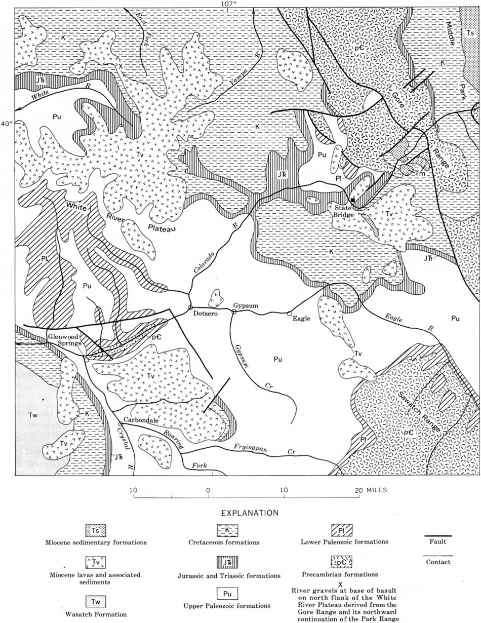
The upper Colorado River basin is mostly in the Southern Rocky Mountains, but includes the northeast part of the Colorado Plateau. The present course of the main stem of the river (fig. 32) is no older than very late Miocene and may be as young as Pliocene. Before middle Miocene time, the headward part of the Colorado River drained westward at about the position of the White River (fig. 33).
|
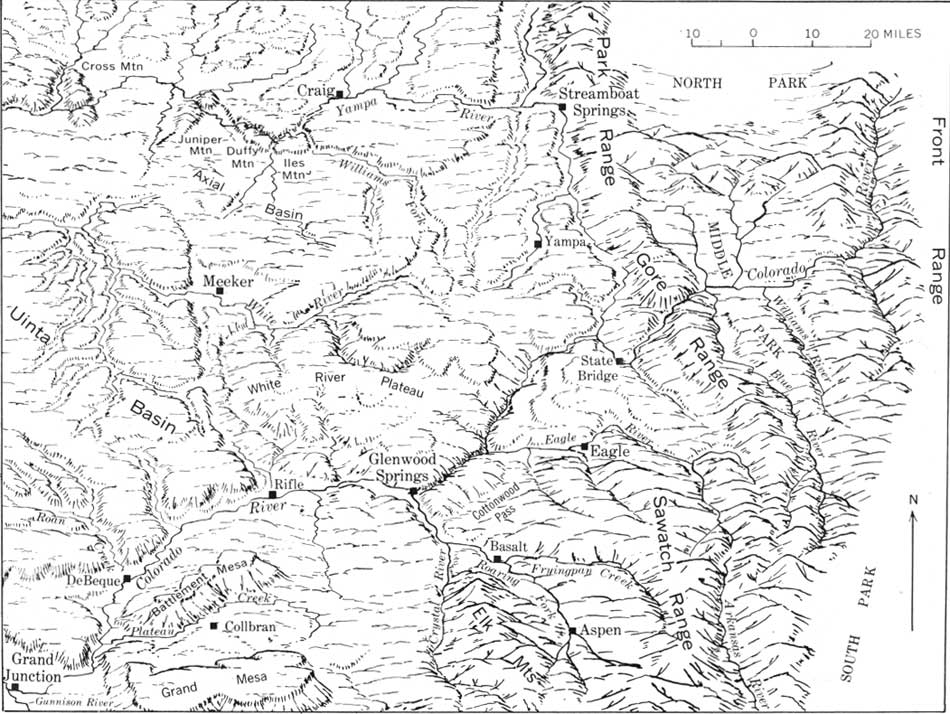
| FIGURE 32.—The Colorado River and its tributaries above Grand Junction. The river is in deep canyons where it crosses the uplifted Gore Range and White River Plateau. (click on image for an enlargement in a new window) |
|
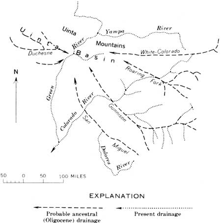
| FIGURE 33.—Probable ancestral (Oligocene) drainage into the Uinta basin and present drainage. The consequent courses of the ancestral White-Colorado, ancestral Duchesne River, and headward part of the ancestral Gunnison River are reasonably certain; the other ancestral courses indicated are conjectural. The present Colorado River has almost no tributaries from the west, and those above its junction with the Green River are short. |
The present drainage pattern here is decidedly askew. All the major tributaries are from the south (fig. 28); the upper 250 miles of the Colorado has no large tributaries from the north. In succession, the Colorado is joined from the south by the Blue, Eagle, Roaring Fork, and Gunnison Rivers (fig. 32) and the Dolores-San Miguel Rivers. This skewed pattern indicates that this part of the main stem of the river is young.
In Oligocene time, the ancestral headwaters of the Colorado River discharged westward to the Uinta basin across what is now the north-trending structural depression occupied by the headwaters of the Yampa River (figs. 32, 33). The drainage was westward from the Park Range and possibly from the Front Range and across the north flank of what is now the White River Plateau. This course is recorded by river gravels under the tuffaceous beds and lava, thought to be of early Pliocene age, capping that part of the plateau. Samples of the gravels recording the ancestral westward drainage were examined by Ogden Tweto who identified in them Precambrian rock types like those in the Park Range to the east. The gravels now are at an altitude of 10,400 feet, but part of this high altitude is due to 2,000 feet or more of late Tertiary or Quaternary uplift of the White River Plateau. The course farther west is not known, but probably continued near the present position of the White River, which approximately follows the axis of the Uinta basin. This basin was downfolded during Eocene and Oligocene time as well as later, and its synclinal axis would likely be the location for early consequent drainage westward from the Rocky Mountains.
At present, the Colorado River crosses in succession: Middle Park (fig. 34), a Miocene (and older) basin; the Gore Range (fig. 35), a mountain barrier dating from the early Tertiary but re-uplifted in late Miocene and Pliocene time; a faulted syncline and second uplift immediately west of the Gore Range; another syncline in Miocene lavas and sedimentary rocks at State Bridge (fig. 36); and still another uplift at the White River Plateau (fig. 37), which also was raised in late Tertiary time.

|
| FIGURE 34.—Valley of the Colorado River in Middle Park, a structural basin in the Rocky Mountains, view west. On the skyline is the Gore Range, a block of Precambrian rocks that was repeatedly uplifted across the river's course during middle and late Tertiary time and which repeatedly dammed the river in Middle Park. |
|
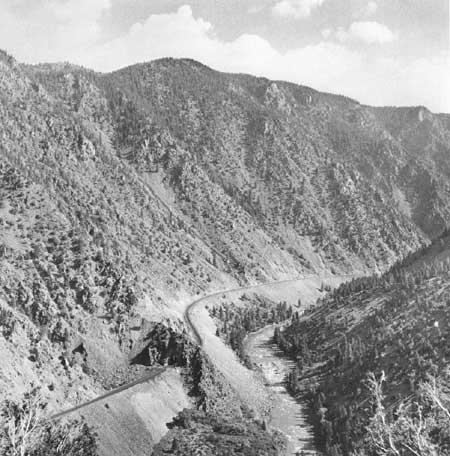
| FIGURE 35.—Canyon of the Colorado River through the uplifted Precambrian rocks of the Gore Range; view upriver toward northeast. Repeated uplift of the range during middle and late Tertiary time slowed or even ponded the Colorado River in Middle Park, the big structural basin upstream from these mountains. This uplift probably occurred as repeated small movements, but each time the river would overflow via the uplifted canyon and cut it deeper. The canyon, therefore, is in part antecedent even though the river initially may have been superimposed across the uplift. |
|
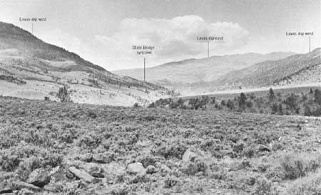
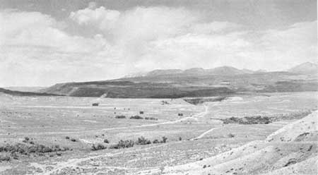
| FIGURE 36.—Valley of the Colorado River where it enters the State Bridge syncline. The valley is in this structural basin between the Core Range and White River Plateau; view is west, downvalley. Miocene lavas forming the near mountains dip downvalley, away from the observer; in the distance the lavas rise again towards the White River Plateau. The axis of the downfold crosses the Colorado River in the distant transverse valley. |
|
| FIGURE 37.—East flank of the uplift at the White River Plateau, view west. The Colorado River is in the canyon in the middle distance and flows against the dip of the Mesozoic formations underlying the plateau. Lavas, thought to be late Miocene or early Pliocene in age on top of the plateau (skyline), extend unconformably across Cretaceous, lower Mesozoic, and Paleozoic formations. These lavas indicate middle or early Tertiary uplift of the plateau. Upper Miocene lavas in the basins east and south of the plateau have been uplifted 2,000 feet or more as a result of renewed movement in Pliocene and Quaternary time. The river, which crosses the uplift in a deep canyon (Glenwood Canyon), probably was superimposed across the uplift from the lavas or associated deposits, but deepening of the canyon was evidently due to downcutting as uplift continued; that is, the canyon is in part antecedent. |
These structures in the Rocky Mountains repeatedly ponded the ancestral Colorado River and turned it southward around the White River Plateau. The present river valley across these basins and ranges is younger than the sedimentary rocks and lava, mostly of Miocene age, downfolded in the basins.
The relationship of the river's course to the mountains and basins is well illustrated by the syncline at State Bridge, between the Gore Range and the White River Plateau (fig. 38). This syncline, which extends north along the headward part of the Yampa River, contains thick deposits of lavas and volcanic ash inter-bedded with coarse clastic sedimentary rocks that have yielded vertebrate fossils of late Miocene age (fossils from Piney Creek, south of State Bridge; G. E. Lewis, written commun., 1968). The lavas and sedimentary rocks have been downfolded between the uplifted Gore Range and White River Plateau (figs. 36, 37). Lavas in the State Bridge syncline and in the structural depression southeast of Glenwood Springs, rise onto the White River Plateau which is capped by similar lavas and tuffaceous beds. These lavas capping the plateau are assumed to be no younger than those capping Grand Mesa, which have been dated by potassium-argon methods at 9.7 million years±0.5 million years (John Donnell, written commun., 1966).
|
| FIGURE 38.—The upper Colorado River basin in the Rocky Mountains (generalized from Burbank and others, 1935). The river crosses in succession, a basin containing middle Tertiary deposits at Middle Park, uplifted Precambrian rocks in the Gore Range, a second basin containing middle Tertiary sedimentary rocks, uplifted Precambrian rocks overlain by lavas which form the east flank of the State Bridge syncline and the east flank of the White River Plateau; then the river flows in a canyon to Glenwood Springs. (click on image for an enlargement in a new window) |
Structural uplift at the White River Plateau has been about 12,000 feet; most of this occurred before the lava cap was formed, because the lava extends unconformably across at least 8,000 feet of Paleozoic and Mesozoic rocks on the flanks of the uplift (figs. 37, 38). If 10,000 feet of the uplift occurred before the lava cap was formed, and 2,000 feet after that, the main stem of the Colorado River may have been superimposed across the uplift from the lava cap. The canyon above Glenwood Springs was probably cut during Pliocene and later time and is partly antecedent. Dips of the lavas into the State Bridge syncline and into the depression southeast of Glenwood Springs indicate that 2,000 feet or so of Pliocene and later uplift occurred at the plateau. A sixth of the uplift seems to have occurred during the last sixth of Cenozoic time, as if deformation there has progressed linearly with time.
Also, on the east side of the State Bridge syncline, the lavas rise towards the Gore Range (fig. 36). Early uplift of that range is indicated by the overlap of the lavas on the flanks, analogous to those around the White River Plateau; late Tertiary uplift is indicated by the folding of the upper Miocene lavas and sedimentary rocks forming the east flank of the State Bridge syncline. Similar structural history in Middle Park is recorded by Miocene stream and lake deposits there (Troublesome Formation).
The present course of the Colorado River through Middle Park, across the Gore Range, State Bridge syncline, and White River Plateau, clearly is younger than the lavas and sedimentary rocks in the basins and apparently became established by being superimposed across the structures at the very end of Miocene time or the beginning of Pliocene time. The canyons, though, seem to be antecedent.
Lower and middle Tertiary gravel deposits are too scattered to indicate the pattern of the other ancestral drainage. My guess is that when the ancestral Colorado River was north of the early Tertiary dome at the White River Plateau, Eagle River was south of the dome. This interpretation is suggested by the fact that rock types of the kind occurring in the headwaters of the Eagle River have not been found in the gravels interbedded with the lavas in the State Bridge syncline. The ancestral Roaring Fork may have drained westward to join the Gunnison River at Grand Mesa; if so, it probably was turned northward by the uplift recorded by the downstream rise of the Precambrian rocks along the Gunnison River (p. 74).
The amount of canyon deepening along the Colorado River in the Rocky Mountains during the Quaternary seems to have been about 750 feet. At the upper end of Glenwood Canyon, about 300 feet above the Colorado River, is a bed of volcanic ash correlated with the Pearlette Ash Member of the Sappa Formation of Pleistocene age (late Kansan or Yarmouth age; H. A. Powers, cited in Morrison, 1965, p. 36). A similar ash bed at the upper end of the Black Canyon of the Gunnison River and only 200 feet higher than the river suggests even less Quaternary downcutting there. These estimates, of course, assume that uplift and downcutting were both proportional during the early and late Pleistocene. The amount of Quaternary downcutting was probably very much greater near the mountain summits, however (fig. 39). (See for example Wahlstrom, 1947; Richmond, 1962.)
|
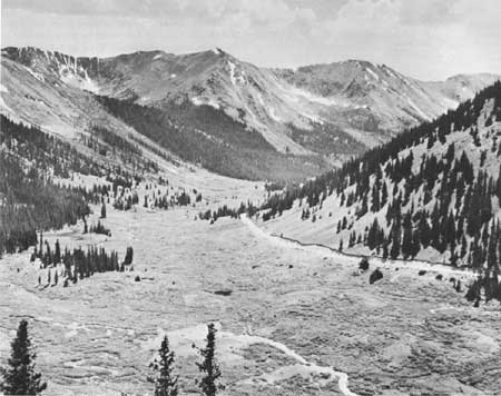
| FIGURE 39.—U-shaped glaciated valley at the head of Roaring Fork. Valleys as large as this (1,300 ft. deep) at the heads of rivers in the Rocky Mountains are generally interpreted as having been eroded during the Pleistocene. Valley deepening downstream during the Pleistocene, however, was only half as much or less. View along highway below Independence Pass. |
The valleys of the Colorado, Eagle, Fryingpan, and Roaring Fork, and the headward part of the Yampa, are mostly 3,000-4,000 feet deep and have been eroded in the last 10 million years. The amount of valley deepening during the Pliocene and during the Quaternary seems to have been roughly proportional to the time involved. Except in the very heads of the valleys, as in the cirques, the oldest Pleistocene morainal deposits are 500-750 feet above the present drainage, which seems to be about the amount of Pleistocene and Holocene downcutting. In general, therefore, these valleys were deepened about 3,000 feet during the Pliocene and a fifth that amount during the Quaternary. Uplift of the barriers crossed by the rivers has been renewed recently enough so that the river gradient is greatly steepened at each barrier (fig. 40), and it seems to have been rapid enough to have caused diversions that have resulted in wind gaps (fig. 41).

|
| FIGURE 40.—Profiles of the Colorado River in the Southern Rocky Mountains, showing the steepened gradients where the river is in canyons crossing the structural barriers. |
|
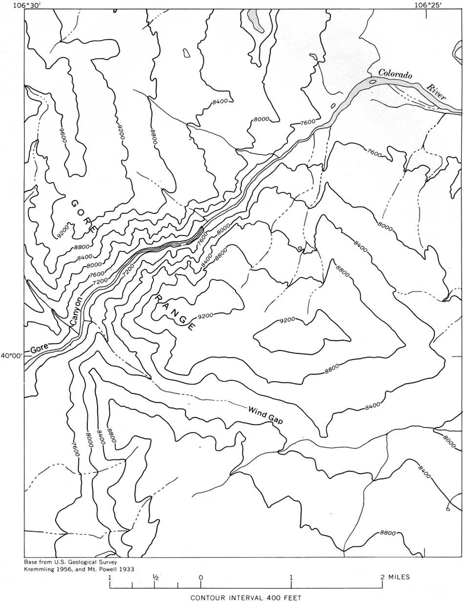
| FIGURE 41.—Wind gap in the Gore Range south of Gore Canyon. East of the range is a wide valley (Blue River) which joins the Colorado about 3 miles east of Gore Canyon. The wind gap probably represents a former course of Blue River (or possibly even of the Colorado River) prior to late Tertiary uplift of the Gore Range. (click on image for an enlargement in a new window) |
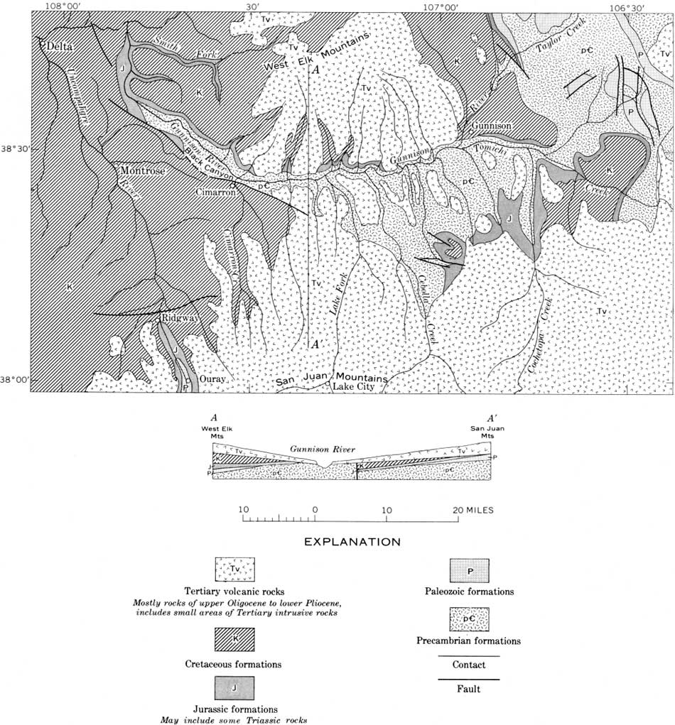
In the Gunnison River valley, some parts of the valley are demonstrably old, whereas others are demonstrably young. This is the oldest recognizable valley in the Colorado River basin above Grand Junction. It is a consequent valley in Precambrian rocks (figs. 31, 42), and it illustrates the mixing of processes and ages of valley cutting. The valley is partly filled with Oligocene and Miocene volcanic rocks from the San Juan and West Elk Mountains. The ancestral consequent valley—consequent on the uplift of the Rocky Mountains—predates the volcanic rocks, but the present valley is cut into these rocks and therefore is younger.
|
| FIGURE 42.—Gunnison River valley, Colorado (generalized from Burbank and others, 1935). The river cut into Precambrian rocks before eruption of the volcanic material that poured into the valley from the San Juan Mountains and West Elk Mountains. The eruptions began in Oligocene time and continued through the Miocene and into the Pliocene. The valley of the Gunnison River dates from the Oligocene (about 35 million years); some of its tributaries from the San Juan Mountains are incised into Pliocene lavas and occupy young valleys (about 5 million years). (click on image for an enlargement in a new window) |
In middle and late Tertiary time the Gunnison valley was tilted 1,400 feet or more eastward against the flow of the river, as indicated by the eastward tilt of the synclinal lavas (fig. 43). That some of the tilting is Quaternary (and perhaps continuing) is suggested by the geomorphology of the valley and habit of the rivers. Near Gunnison, upstream from the Black Canyon, the valleys are in Precambrian rocks as at Black Canyon, but they are wide and bordered by low rounded hills that appear old compared with the steep-walled canyons farther west. Moreover, both Gunnison River and its principal tributary there, Tomichi Creek, meander lazily in a marshy flood plain with gradients only 15 feet per mile. Through Black Canyon, the gradient is more than twice that and for considerable stretches is about 100 feet per mile. Also, according to Hansen (oral, commun., 1966), Quaternary gravels on the northeast side of Black Canyon uplift are tilted.

|
| FIGURE 43.—Structure contours drawn at the base of lavas and related eruptive rocks filling the Gunnison River valley; the lavas occupy a trough coinciding with the river valley and inclined more than 1,400 feet upstream (to the right). Much or most of this warping of the lavas occurred in late Tertiary time. (From Hansen, 1965a, fig. 23.) (click on image for an enlargement in a new window) |
On Grand Mesa (fig. 47), river gravels at 8,500 feet altitude overlie Eocene lake beds (Green River Formation) and are overlain by basaltic lava dated as earliest Pliocene. Rock types in the gravels are like intrusive rocks in the Elk and West Elk Mountains to the east (Ogden Tweto, written commun., 1968) and probably are Miocene in age. The ancestral Gunnison River in that vicinity at that time could not have been much lower, which suggests that the eastward tilting noted in the Gunnison valley probably extended this far west in late Tertiary and Quaternary time.
Cutting of Black Canyon (about 2,500 ft deep) began in Pliocene time, and about 2,000 feet of downcutting had taken place before the glaciation during Pleistocene time. The bed of volcanic ash (identified as Pearlette Ash Member of the Sappa Formation, Hanson, oral commun., 1966) only 200 feet above the river at the upper end of Black Canyon indicates only about 200 feet of downcutting there in the later Pleistocene. About 400 feet of downcutting seems indicated for the whole of Pleistocene time.
Two quite different kinds of drainage changes that may occur during uplift are illustrated in figures 44-46. In one, the drainage courses shifted during uplift; in the other, the drainage course remained the same during uplift, but the valley was deepened.

|
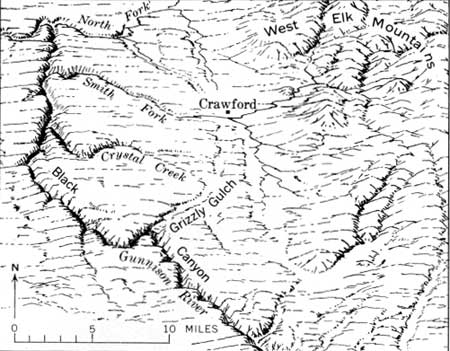
| FIGURE 44.—Black Canyon of the Gunnison River (foreground), in Precambrian rock, is 2,500 feet deep. View is northeast to the West Elk Mountains (on skyline). Uplift of the Precambrian rocks, while the canyon was being eroded, diverted drainage that formerly came to Black Canyon from the West Elk Mountains; the abandoned valley has been left hanging. |
|
| FIGURE 45.—Example of drainage changes during uplift at Black Canyon. Grizzly Gulch and Crystal Creek, that flowed to the Gunnison River across the hard-rock core of the uplift, were captured by more rapidly eroding streams that flowed to Smith Fork through soft rocks. Grizzly Gulch now is a hanging valley and contains Quaternary gravels tilted northeast (Hansen, 1966). Tributaries of the North Fork of the Gunnison are about to capture Smith Fork and turn it northward at the vicinity of Crawford, where a divide of soft rocks, about 50 feet high, holds the stream on a course about 1,000 feet higher than the North Fork only 8 miles away. |
|
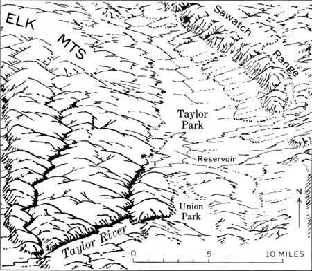
| FIGURE 46.—Taylor Park, a structural basin between the uplifted Elk Mountains and Sawatch Range, is drained by way of Taylor River canyon. The Elk Mountains, which are crossed by the canyon, are a block of Precambrian and Paleozoic rocks raised structurally many thousands of feet above Cretaceous formations in the valley immediately to the west. The surface of the uplifted block plunges eastward under Taylor Park. |
In brief, the Black Canyon of the Gunnison is partly the result of the river being superimposed from the volcanic rocks that buried a mountain of Precambrian rocks, and it is partly antecedent, the result of canyon deepening because of renewed doming at Black Canyon. The ancestral valley of the Gunnison is consequent and old—Oligocene. The present valley above the Black Canyon is antecedent across the eastward tilt of the lavas, and it and its southern tributaries, in part deeply incised into Pliocene formations, are young. Still other valley features seem attributable to Quaternary events, and there are examples of quite different kinds of valley adjustments to deformation. The Gunnison River valley provides good examples of how thoroughly different processes and different ages of valley cutting may be combined to produce a river system.
Similar drainage changes on a larger scale seem indicated along the Uncompahgre River. Where it emerges from the San Juan Mountains above Ridgeway (fig. 47), volcanic rocks rise 2,000 feet east and west above the valley floor. In part this may be an old valley, like that the Gunnison, partly filled with volcanic rocks, but the valley is also in part a structural depression.
The original drainage seems to have been northwest past Horsefly Peak on the Uncompahgre Plateau (fig. 47), where gravel deposits derived from volcanic rocks in the San Juan Mountains are at 10,000 feet altitude. These gravels are 2,000 feet higher than the base of the volcanic rocks along the Uncompahgre River, and most of this difference (about 1,500 ft) seems attributable to the late Pliocene and Quaternary uplift of the Uncompahgre Plateau described by Cater (1966). The gravels may be as old as Miocene. Similar but lower gravels northwest of Horsefly Peak probably represent progressive monoclinal shifting of the Uncompahgre River northeast down the flank of the plateau to its present valley.
|
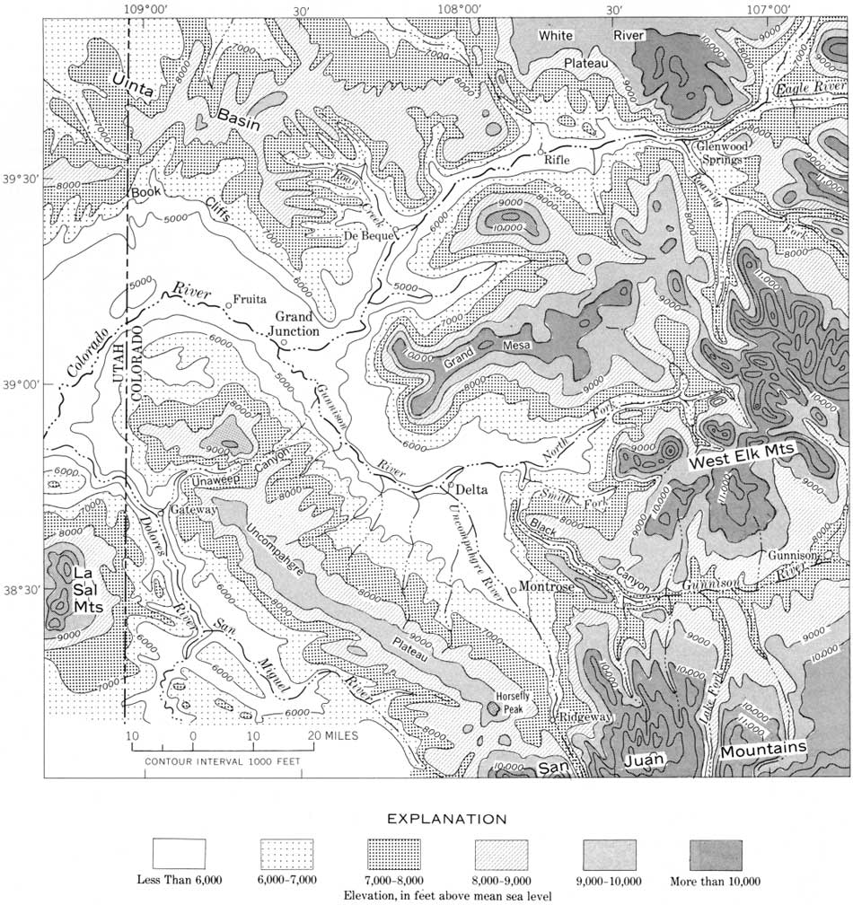
| FIGURE 47.—Altitudes in the Grand Junction area, where the Gunnison joins the Colorado River. (click on image for an enlargement in a new window) |
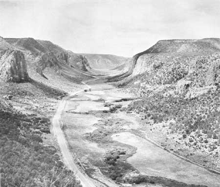
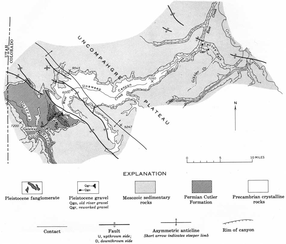
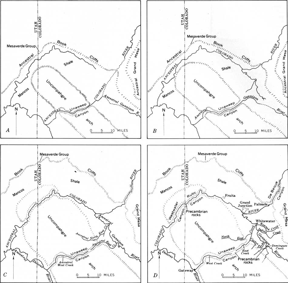
In the vicinity of Grand Junction is the most spectacular example of drainage diversion in the whole drainage basin, a diversion caused by uplift and abandonment of a large canyon (fig. 48). Unaweep Canyon, 2,000 feet deep, as much as 4 miles wide at the rim, and having a floor a mile wide in gneissic Precambrian rocks, is an elevated nearly dry canyon that extends across the Uncompahgre Plateau (figs. 47, 49). Two small streams now drain to the opposite ends of the canyon, but they are much too small to have carved the big valley in such resistant rocks. They are excellent examples of underfit streams. The divide between their heads is 2,000 feet higher than the nearby stretches of the Colorado and Dolores Rivers. The canyon was cut by a major river, certainly the Gunnison and probably also the Colorado, that discharged southwestward across the Uncompahgre Plateau when it was lower than it is now. The structural and drainage changes there (fig. 50) have recently been described by Lohman (1965) and Cater (1966).
|
| FIGURE 48.—Unaweep Canyon, the abandoned canyon of the Gunnison River, and probably of the Colorado River, across the uplift at the Uncompahgre Plateau. The mile-wide canyon is in Precambrian gneissic rocks (lower cliff) overlain by Triassic rocks (form slope on skyline) and Jurassic sandstones (cliff on skyline). The uplift that elevated this canyon and diverted its drainage occurred in very late Pliocene or early Pleistocene time. |
|
| FIGURE 49.—Unaweep Canyon and part of the Uncompahgre Plateau. (From Cater, 1966, p. C87) (click on image for an enlargement in a new window) |
|
| FIGURE 50.—Probable sequence of drainage changes where the Colorado River crosses the Uncompahgre Plateau (from Lohman, 1965, p. 71). A, earliest stage, Pliocene; B, C, latest Pliocene and earliest Pleistocene; D, present. (click on image for an enlargement in a new window) |
Gravels deposited by the Gunnison River when it flowed westward through the canyon have been found at both ends (Cater, 1966). Those at the southwest end are 1,400 feet lower than the floor of Unaweep Canyon in the center of the plateau and indicate that the south west flank of the plateau has been uplifted this amount since Unaweep Canyon was abandoned (Cater, 1966, p. C91). Moreover, those gravels are within 200 feet of the present level of the Dolores River and indicate that the river has cut downward no more than that since the gravels were deposited. Thus, it follows that the amount of downcutting by the Dolores River since Unaweep Canyon was abandoned probably is only about 100 feet, because part of the difference in altitude probably is due to uplift of the gravels when that flank of the Uncompahgre Plateau was folded (Cater, 1966, p. C91). As a result of correlating these gravels with deposits in the La Sal Mountains, Cater (1966, p. 90-91) infers that Unaweep Canyon was abandoned in late Pliocene, or possibly earliest Pleistocene time.
During the early history of Unaweep Canyon, the Colorado may still have been ponded, at least intermittently, in the structural basins above the White River Plateau and Gore Range. The stretch of river above Grand Junction may have originally headed near Rifle. This may have been the situation at one time because this section (Grand Junction to Rifle) is the only stretch of the Colorado River above its junction with the Green where the tributaries are symmetrically arranged on both sides (fig. 32). This drainage pattern above Grand Junction would be younger than the lavas on Grand Mesa, presumably early Pliocene, which is about the time suggested for the Colorado, Eagle, and Roaring Fork to have been turned into their present courses. Midway between Grand Junction and Rifle the old drainage would have been roughly 3,000 feet above the present river level.
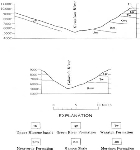
Evidence has already been presented indicating that the Gunnison is at least twice as old as this stretch of the Colorado River upstream from Grand Junction, and it looks it, for it is as deep and twice as wide (figs. 51, 52). The fact that the bigger stream, the Colorado, has the smaller valley probably reflects the difference in age because both are in easily eroded rocks.
|
| FIGURE 51.—Cross profiles illustrating contrast in valleys of the Gunnison and Colorado Rivers. Each profile is about 25 miles above the junction of the two rivers. Both rivers flow across nonresistant rocks. |
|
| FIGURE 52.—Valley of the Colorado River where it crosses the east end of the Uinta basin. After leaving the Southern Rocky Mountains, the Colorado River enters the Colorado Plateau and crosses the eastern end of the Uinta basin in this deep valley carved in the Green River Formation (Eocene), upper two-thirds of the cliff, and the Wasatch Formation (Paleocene and Eocene), base of the cliff. Locally there are lavas on the plateau surface above the Green River Formation; these have been dated radiometrically as early Pliocene (about 10 million years old). In places, the lavas overlie river gravels. View is northwest, about 20 miles west of Rifle, Colo. Mount Logan (peak at left) is at an altitude of 8,444 feet; the river (marked by trees) at the base of the mountain is about 5,000 feet in altitude. |
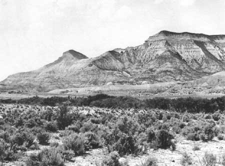
Late Tertiary and Quaternary structural deformation took place south of the Uncompahgre Plateau near the La Sal Mountains. These mountains were domed by intrusions (laccoliths) in middle Tertiary time; they have been dated by potassium-argon methods at 25 million years (Stern and others, 1965). The Dolores River swings in a wide arc around the mountains and, in doing so, must cross, nearly at right angles, a series of faulted anticlines underlain by salt beds in the Pennsylvanian Paradox Formation (fig. 53). The Colorado River after being joined by the Dolores, crosses the faulted anticlines west of the La Sal Mountains. The downfaulted crests of the anticlines contain conglomerate (Hunt, 1958, p. 314; Carter and Gualtieri, 1965) that probably is Pliocene in age. The conglomerates are younger than the intrusive rocks and contain gravels derived from them; in Castle Valley, conglomerate 1,000 feet thick is vertical and is unconformably overlain by two or more boulder deposits, till, and glacial outwash of pre-Wisconsin age (Hunt, 1958, p. 314; Richmond, 1962, p. 93-94). The deformation presumably is due to movement of the salt, perhaps attributable to accelerated solution during the Pleistocene when melt waters discharged from the snowfields and glaciers on the La Sal Mountains.
|
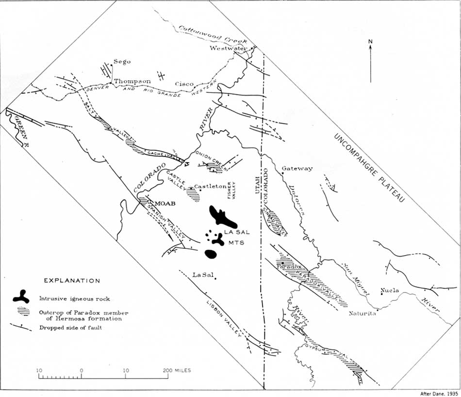
| FIGURE 53.—Relation of the Dolores and Colorado Rivers to the northwest-trending faulted anticlines southwest of the Uncompahgre Plateau (from Dane, 1935). (click on image for an enlargement in a new window) |
Before the oldest till overlying the tilted Pliocene (?) conglomerate was deposited, the Colorado River already was deep in its canyon where it crosses the faulted anticlines; no more than 500 feet of downcutting there is attributable to the Quaternary, although in the La Sal Mountains, 1,000 feet or more of valley deepening is attributed to the Quaternary (Richmond, 1962, p. 93-94).
On the west slope of the San Juan Mountains, at Glade Park, Shawe (1968) found deposits clearly derived from the San Juan Mountains, now isolated by erosion from their source; valleys there have cut 1,000 feet into Mancos Shale since the deposits were formed, which is like the deep erosion in the La Sal Mountains and along tributaries of the Gunnison River on the north flank of the San Juan Mountains (p. 75). The headward parts of valleys in the mountains of the Colorado River drainage basin were greatly deepened during Quaternary time, but along the main stems, maximum cutting during the Quaternary does not seem to have exceeded about 500-750 feet.
The Dolores River provides another example of stream diversion, canyon deepening by antecedence, and a means of estimating the amount of lowering by erosion of the Colorado Plateau in southeastern Utah during late Tertiary and Quaternary time. The river begins with a consequent southwesterly course off the San Juan Mountains (fig. 54). In this consequent course, the valley is 2,500 feet deep in southwest-dipping Jurassic and Triassic formations and has a gradient averaging about 50 feet per mile. Where it turns sharply northward, the canyon is about 200 feet deep in the Morrison Formation, and the gradient is less than 25 feet per mile. The drainage arrangement suggests that the Dolores originally continued its consequent southwesterly course to join the San Juan River and that it was turned northward when the laccolithic intrusions domed Ute Mountain. I assume that the intrusions at Ute Mountain are early Miocene, like those at the La Sal Mountains (p. 78).
|
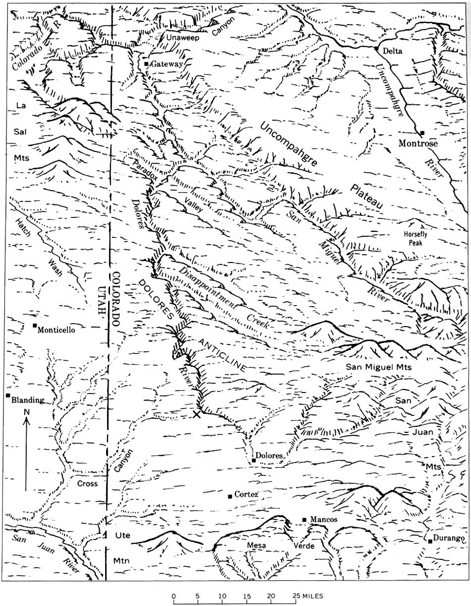
| FIGURE 54.—Dolores River drainage basin. The headwaters of the river probably originally flowed southwest from Dolores to join the San Juan River; they may have been turned northward by the early Miocene doming at Ute Mountain. A gravel deposit (X), on the west rim of the north-trending canyon, forms the divide between the Dolores River and drainage to the southwest. When the Dolores River deposited the gravel there must have been hills of Cretaceous shale at the site of Cross Canyon and the canyons northwest of it. (click on image for an enlargement in a new window) |
After turning the bend, the Dolores River takes a northerly course across the broad northwest-trending Dolores anticline (fig. 54). Where the river crosses the crest of the fold, rock units are 1,000 feet structurally higher than at the bend, and the river gradient on the southern flank of the fold is about 20 feet per mile. At the crest, where the river again has cut into Triassic rocks, it meanders widely and then plunges 40 feet per mile down the north flank of the fold. Almost certainly this canyon has been arched by the same kind of uplift that led to abandonment of Unaweep Canyon; if there had been resistant rocks in the canyon across this fold, like the Precambrian rocks at Unaweep Canyon, the Dolores River might have turned to a new course. Warped Pleistocene gravel terraces along Disappointment Creek (Shawe, 1968) show that some of the deformation in this area is Quaternary.
Evidence bearing on erosion of the plateau surface in southeastern Utah in late Tertiary and Quaternary time is provided by a deposit of Dolores River gravel along the west rim of the Dolores River canyon, where it enters the south flank of the Dolores anticline. The deposit forms the divide at the head of drainage to Cross Canyon and the San Juan River (fig. 54). When that gravel was deposited there must have been hills of Mancos Shale on what is now a stripped plain on resistant sandstone (Dakota Sandstone); the sandstone and the plain formed on it slope 2,000 feet southwest to the bluffs overlooking the San Juan River. Between the anticline and the San Juan River the structural relief is 4,000 feet.
Southeastern Utah and southwestern Colorado must have been largely covered by Cretaceous formations when the laccolithic mountains formed in early Miocene time because Cretaceous shale, intruded by laccoliths, is still preserved at all of the mountains, even including the Abajo Mountains, which are on top of an upwarp. Also, there are reasons for supposing that in Miocene time, southeastern Utah was structurally lower than it is now (p. 99). The Dolores anticline forms the southern boundary of the salt anticlines and probably is related to the parallel Uncompahgre Plateau which forms the north boundary. It is assumed, therefore, that there was renewed uplift on this fold in late Tertiary and Quaternary time, that the Dolores River deepened its canyon across the fold as the uplift continued (antecedence), and that at least 2,000 feet of the structural relief between the anticline and the San Juan River is due to late Tertiary or Quaternary earth movement.
By this interpretation, Cross Canyon and the other streams draining southward to the San Juan River are consequent streams and largely of late Tertiary and Quaternary age. The stripped surface now is blanketed by a loess deposit that, judging by its intensive weathering and burial by fan gravels at the foot of the Abajo Mountains, is probably middle glacial Pleistocene in age (about 500,000 years ago). The Mancos Shale had been stripped from the plain before this loess was deposited. The assumption of late Tertiary and Quaternary uplift at the Dolores anticline also helps explain why the Dolores River did not take a consequent northwesterly course at the position of Hatch Wash (fig. 54). The northward course would be along an older north-trending syncline west of the San Juan Mountains and east of the Monument upwarp and domes at the Abajo and La Sal Mountains; the northwesterly structural features are attributed to late Tertiary and Quaternary deformation, and the Dolores River has maintained an antecedent course across them. The same might apply to the Colorado River, which crosses the structural features west of the La Sal Mountains.
At Moab, the Colorado River begins a meandering course southwestward against the regional northward dip (figs. 55, 62) and has a gradient of only about 1 foot per mile. The canyon, cut into Jurassic, Triassic, and upper Paleozoic rocks, consists of an outer rim of Jurassic and Triassic strata and an inner gorge in Paleozoic strata (fig. 56). The outer rims are 8-10 miles apart; the inner gorge is 1-2 miles wide. River gravels were not found more than about 500 feet above the river and only in the inner gorge. No river gravels were found on the broad stripped bench back from the inner gorge; gravel deposits there are locally derived fan gravels from the outer rim. The river gravels surely are Quaternary, and most of the cutting of the inner gorge probably occurred during the late Pliocene and Quaternary while uplift continued in southeastern Utah.

|
| FIGURE 55.—Crossing the Canyonlands section of the Colorado Plateau, the Colorado and Green Rivers are in deep colorful canyons in Jurassic, Triassic, Permian, and Pennsylvanian rocks. This view of the Colorado is northeast (upstream) at The Loop about 6 miles above the junction with the Green River. The gorge is about 500 feet deep; the broad bench (most of photograph) is underlain by the Permian (Cutler Formation), and no river gravels were found on it. In the distance, about 8 miles away, are the cliffs of the Triassic and Jurassic rocks, about 1,200 feet high (compare with fig. 56). In early Miocene time (about 25 million years ago) much or most of the canyonlands still were covered by Cretaceous shale (Mancos Shale). River deposits correlated with glacial deposits in the La Sal Mountains indicate about 500 feet of canyon deepening during Quaternary time (the last 2-3 million years). |
|
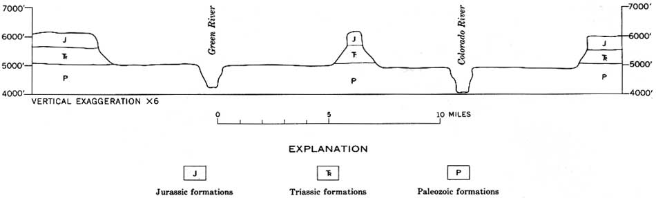
| FIGURE 56.—Generalized profile across the canyons of the Colorado and Green Rivers, about 15 miles above their junction. The rivers are in an inner gorge carved in upper Paleozoic rocks that form broad benches. River gravels were not found on the benches, only fan deposits (derived from the outer cliffs which are composed of Triassic and Jurassic rocks). (click on image for an enlargement in a new window) |
| <<< Previous | <<< Contents >>> | Next >>> |
pp/669/secc3.htm
Last Updated: 22-Jun-2006