
|
Geological Survey Professional Paper 669
The Colorado River Region and John Wesley Powell |
DESCRIPTIVE GEOLOGY
(continued)
Green and Yampa Rivers
Green River did not join the Colorado River system until after the Miocene (?) Browns Park Formation was deposited. The river entered Browns Park valley at the north foot of the Uinta Mountains after the uppermost beds of the Browns Park Formation there had been deposited and supposedly the river continued eastward, but where it went is uncertain. Subsequently, it turned southward into Lodore Canyon across the Precambrian rocks uplifted in the Uinta arch (fig. 57, 58). This diversion occurred no earlier than late Miocene time. Green River is the type example for Powell's antecedent stream, but the age relations do not allow this stretch of Green River to be older than the Uinta Mountains, the earliest uplift of which antedates the Eocene Green River Formation. Powell's theory of antecedence was dismissed in favor of the theory that Lodore Canyon resulted from the river being superimposed from beds of the Browns Park Formation that extended across the uplifted Precambrian rocks.
|
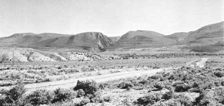
| FIGURE 57.—Gates of Lodore, where the Green River leaves its open valley in Browns Park (foreground) and flows in a canyon that crosses the Uinta Mountains. Powell (1875) believed that the canyon was antecedent. Critics pointed out that the mountains date from early Tertiary time and that the river could not be that old because it is flowing on upper Tertiary strata. They assumed that the river must have been superimposed from upper Tertiary sediments that filled Browns Park and extended across the tops of the mountains. The interpretation offered in this report assumes that both Powell and his critics are partly right, that the river course was determined by superposition when the mountains were not much, if at all, higher than Browns Park, and that renewed uplift of the mountains (or downwarping of Browns Park) enabled the canyon to be deepened (antecedent). |
|
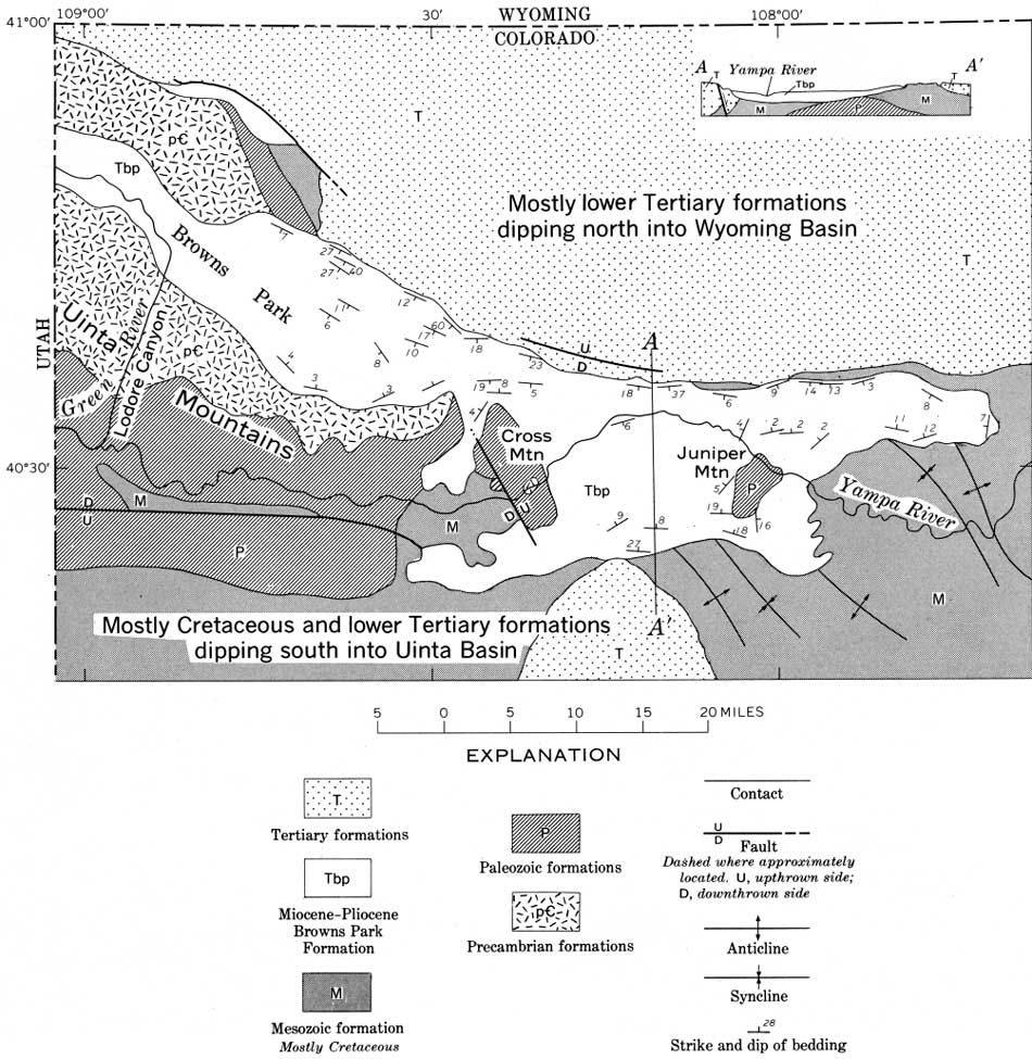
| FIGURE 58.—Northwest Colorado (formation boundaries generalized from Burbank and others, 1935), showing distribution of the Miocene(?) Browns Park Formation along the Yampa River and in Browns Park (strike and dip symbols in Browns Park Formation and cross section generalized from Sears, 1924a, pl. 35). The Browns Park Formation occupies a structural depression that lies along the structural arch forming the Uinta Mountains. Precambrian, Paleozoic, Mesozoic (mostly Cretaceous), and lower Tertiary formation are anticlinally folded under the arch. (click on image for an enlargement in a new window) |
Antecedence also was dismissed as an explanation for the several canyons by which the Yampa River crosses uplifts. Yampa River joins the Green River in a canyon within the Uinta Mountains rather than in the open country to the north or south.
Superposition by itself, however, seems untenable. This theory first requires that the Browns Park Formation cover the eastern 50 miles of the Uinta Mountains and the adjoining lower parts of northeastern Utah, northwestern Colorado, and part of southern Wyoming. It further requires the removal of that cover. However, there was not enough time to remove such deep fill completely over that vast area. As that area is only about 5 percent of the Colorado River drainage basin, the volume is also excessive in terms of the amount of material in the Pliocene and younger sediments of the delta.
The conflicting interpretations however, become reconciled by assuming that the river's course was determined by superposition before the last movements of uplift, at the Uinta Mountains (or the last downwarping of the adjoining basins). The canyon could have been deepened during and after that final uplift, and thus be in part antecedent. In my view this is the probable sequence of events, and, if so, Powell was as right as his later critics.
The Yampa River heads in the volcanic rocks and interbedded sedimentary rocks of probable middle and late Miocene age, downfolded in the structural trough extending northward from the State Bridge syncline along the west foot of the Gore and Park Ranges (figs. 32, 38). This headward part, therefore, is no earlier than late Miocene or early Pliocene time.
After turning westward near Steamboat Springs (fig. 32), the Yampa River enters a broad strike valley in Upper Cretaceous shale. The river gradient is about 10 feet per mile. This stretch of valley probably originated at least as early as Miocene time, and perhaps in the Oligocene, as a strike valley along the southern edge of the Eocene rocks on the northeast flank of the White River Plateau. Part of the tilting here is Pliocene, however, resulting from the later stages of uplift at the White River Plateau, and the position of the river in the strike valley very likely has monoclinally shifted northward down the dip as downcutting and tilting progressed.
Farther west (fig. 32), the strike valley is filled with the Miocene (?) Browns Park Foundation (fig. 29), which consists of conglomerate, sandstone, and silt from the surrounding uplands mixed with considerable material of volcanic origin. The Browns Park Formation is similar in age and rather like the Miocene fill along the headward part of the Yampa River and in the State Bridge syncline, but it contains less lava.
Just west of Craig (fig. 32), the Yampa River turns southwest from the open strike valley and enters a canyon in tilted beds of Cretaceous sandstone that rise southward towards the White River Plateau. The position of this canyon probably was determined by superposition from the Browns Park Formation, but it is unnecessary to assume that the fill was as high as the present canyon rims (about 7,000 ft.) If 500 feet of uplift, on this part of the north flank of the White River Plateau is post-Browns Park, the beds from which superposition occurred need not have been any higher than the top of the present fill west of Craig (about 6,600 ft.) This kind and amount of displacement in Pliocene and Quaternary time is quite consistent with the dips in the Browns Park Formation just west of Craig (fig. 58) and with what is known in general about late Cenozoic uplift at the White River Plateau.
This canyon of the Yampa River across the tilted beds has a wildly meandering course with a gradient of only about 5 feet per river mile. This gradient probably reflects the difficulty the river had in maintaining its way while uplift progressed. Similar relationships in the canyons south of the Uinta basin are similarly interpreted (p. 83).
A few miles farther west, at Juniper Mountain, the Yampa has cut another gorge about 600 feet deep through a structural dome of Paleozoic rocks protruding through the Miocene cover (fig. 58). The downcutting here has occurred since earliest Pliocene time.
For 25 miles west of Juniper Mountain, the Yampa River is in the Browns Park Formation until it is again in a canyon through an isolated structural dome, this one at Cross Mountain (fig. 59). This canyon is 1,000 feet deep. Structural relief on the Paleozoic formations is at least 10,000 feet, and there is no problem superimposing the Yampa River across this upfold, as Hancock (1915) suggested, if 500 feet (5 percent) of the doming is due to the Pliocene and younger downfolding of the Browns Park Formation in the adjoining structural basin. By this interpretation the river course was superimposed, but half or more of the depth of the canyon through Cross Mountain is due to antecedence. Seven miles west of Cross Mountain, the Yampa River enters the Uinta Mountains to follow a canyon course for about 25 miles to its junction with Green River.
|
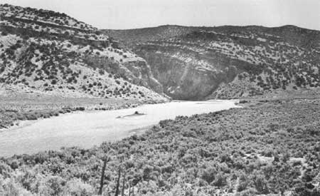
| FIGURE 59.—Yampa River where it emerges from its canyon through Cross Mountain, an uplift involving Paleozoic and Precambrian rocks. The gorge is 1,000 feet deep, yet upstream from it the Yampa River valley is broad and open and 1,000 feet lower than the top of Cross Mountain. In the canyon, Yampa River has a gradient of 60 feet per mile; below the canyon (seen here) the gradient averages 4 feet per mile. |
As already noted, the theory that the canyons of the Green and the Yampa are solely antecedent is untenable because it requires that the rivers and their canyons be older than the initial uplift of the Uinta Mountains, which is earliest Tertiary or possibly even Late Cretaceous. The alternative, that the rivers and the canyons are entirely the result of superposition, however, also seems untenable because it means that the structural basins north, south, and east of the mountains were filled to the height of the canyon rims (present altitudes about 6,000-7,500 ft) and that this vast, depth of fill was then eroded. Bradley (1936) recognized this difficulty and suggested that part of the canyon cutting might be attributed to headward erosion by a stream draining south; by his interpretation, the fill in Browns Park need have been only as high as the wind gap at the head of the south-draining stream. Both hypotheses, superposition and capture, assume that the east end of the Uinta Mountains was structurally stable during late Tertiary and Quaternary time and escaped the folding and warping known to have occurred only a little way to the east.
There has been considerable post-Browns Park deformation in the eastern part of the Uinta Mountains and eastward nearly to Craig (Sears, 1924a, pl. 35; Bradley, 1936, p. 185; Hansen, 1965b, p. 162-166, 171-172). Hansen (1965b, p. 172) notes that a large segment of the eastern Uinta Mountains was tilted northward and eastward after deposition of the Browns Park Formation. Much of the canyon deepening probably occurred because the river was antecedent to this late deformation, and a little evidence that this is what happened is found by comparing the mountains with the Uinta basin to the south.
In the Uinta basin the uppermost formation is the Duchesne River (fig. 60), classed by some as Oligocene (Wilmarth, 1938, p. 637) and by others as uppermost Eocene (Wood and others, 1941, p. 19, pl. 1). Uinta basin was the site of a lake that gradually was filled with sediment and evolved to a playa and, finally, while the uppermost beds of the Duchesne River Formation were deposited, into an alluvial plain (Warner, 1966, p. 949-950). In all probability, the Duchesne River Formation is the youngest deposit laid down in the Uinta basin, and drainage was southward out of the basin from that time on.

|
| FIGURE 60.—Diagrammatic cross section of the Uinta basin north from the Book Cliffs, Utah. The southward rise of the Tertiary formations indicates middle or late Tertiary folding. About one-fourth of the folding is assumed to have occurred in late Tertiary time (modified slightly after Rocky Mountain Assoc. Petroleum Geologists and others, 1951, fig. 61). (click on image for an enlargement in a new window) |
Opinions differ, and probably will continue to differ, about whether the Browns Park Formation ever formed much of a cover across the Uinta basin. I doubt if there ever was much Browns Park Formation deposited there. In the first place, where Green River crosses the Uinta basin, the beds at the surface are playa and fluviatile mudstone (Duchesne River Formation). These beds form a flat upland underlying more than 700 square miles and extending 30 miles east and west from the Green River. The area is smooth except for the valleys cut 100-300 feet into it. The beds are easily eroded and the surface looks like a dissected and slightly lowered playa or flood plain. To me it seems unlikely that such easily eroded beds could have been buried and then exhumed with so flat a surface from under a cover such as the Browns Park Formation. Such could happen to a resistant formation, but hardly likely to easily eroded mudstones. Too, why should the master stream, the Green, be coincidently located in that low part of the Uinta basin where the Duchesne River Formation becomes fluviatile?
Yet, immediately to the north, in the Uinta Mountains, there are thick gravel deposits of the Browns Park Formation on the plateau at Diamond Mountain (altitude 7,500 ft) (fig. 61). According to D. M. Kinney (written commun., 1966), these deposits were laid down in ancient dendritic stream channels that extended eastward towards the present Green River. On the plateau east of the Green River, the same Miocene surface and remnants of the Browns Park Formation are at 8,000 feet altitude. At these present altitudes, the Miocene surface and Browns Park Formation project about 1,500 feet higher than the Duchesne River Formation, where it is turned up against the south side of the mountains. This difference in altitude surely is not an accident of erosion, for it would be strange to have had the Browns Park Formation eroded from the low Uinta basin while it was preserved on the mountains.
|
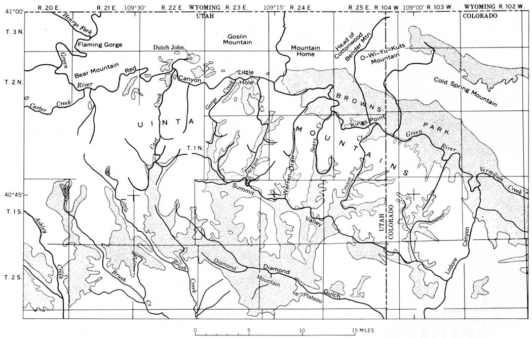
| FIGURE 61.—Eastern part of Uinta Mountains showing Lodore Canyon, Browns Park, Diamond Mountain Plateau and barbed drainage in north part of mountains. Distribution of Browns Park Formation shown by stippled pattern. (Modified from Hansen and others, 1960, p. B258.) (click on image for an enlargement in a new window) |
The difference in altitude between the Browns Park Formation on Diamond Mountain and Yampa Plateau and the Duchesne River Formation in the Uinta basin can be explained by assuming relatively little erosion in the Uinta Basin and about 1,000 feet of post-Browns Park displacement along the steep fold separating the two formations. This is only 5 percent of the total structural relief on that Cenozoic fold, and about 20 percent of Cenozoic time is available for the displacement. It seems unlikely that this part of the Colorado River basin remained stable during late Tertiary and Quaternary time when there was so much deformation in virtually every other part, including areas nearby.
The Miocene surface at Diamond Mountain and adjoining parts of the eastern end of the Uinta Mountains rise northward to a maturely eroded surface having rounded knobs (formed by the Uinta Mountain Group) between broad open valleys floored in part by the Browns Park Formation (fig. 61). These valleys head at wind gaps overlooking the western end of Browns Park and the canyon of Green River farther west. Some of these, notably Cart Creek, formerly drained south, but their drainage now is reversed, as indicated by the barbed tributaries that converge southward. Green River may have first crossed the Uinta arch at Cart Creek, for this underfit stream is cut into a broad valley in the quartzite, almost opposite the place where Green River first bumps into the Uinta Mountains.
In summary, by my interpretation, which assumes 1,000 feet of Pliocene and later displacement of the Uinta basin relative to the mountains, Pliocene and later erosion along the Green and Yampa Rivers would involve: (1) about 500 feet of general lowering by erosion of the Uinta basin at the hogback of the Duchesne River Formation and farther south; (2) about 500 feet of valley deepening by the Green River across the Uinta basin; and (3) about 1,500 feet of downcutting in the canyons of the Green and Yampa Rivers in the Uinta Mountains. This interpretation combines both superposition and antecedence.
| <<< Previous | <<< Contents >>> | Next >>> |
pp/669/secc4.htm
Last Updated: 22-Jun-2006