
|
Geological Survey Professional Paper 669
The Colorado River Region and John Wesley Powell |
DESCRIPTIVE GEOLOGY
(continued)
Canyons South of the Uinta Basin
The increasingly fluviatile sedimentation in the upper part of the Duchesne River Formation and the geomorphology there have been used as the basis for inferring that exterior drainage from the Uinta basin began shortly after the Duchesne River Formation was deposited, that is, in Oligocene or Eocene time. Probably the drainage went to the next basin southward, the Henry Mountains structural basin (fig. 62), but the record has been destroyed by erosion. The Henry Mountains basin had begun to form in earliest Tertiary time because the Waterpocket fold, which forms the west flank of the basin, is overlapped by lower Tertiary formations (Smith and others, 1963, p. 61; see also Gregory and Moore, 1931, p. 116). To reach the Henry Mountains structural basin, the drainage had to cross an uplift that now is structurally 10,000 feet higher than the playa in Uinta basin (fig. 62). In order for the drainage to go south, the surface at the uplift must have been lower than the playa; the difference of 10,000 feet can be attributed partly to deposition in Uinta basin, partly to Oligocene and earlier erosion in the south, and partly to renewed late Tertiary uplift at the south.
|
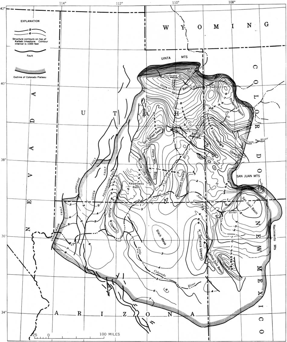
| FIGURE 62.—Top of the Kaibab Limestone in the Colorado Plateau (from Hunt, 1956, p. 52). The map shows that the southwest rim of the plateau is structurally high (the Kaibab Limestone there is at an altitude of more than 7,000 feet) and that the north part is structurally low (the Kaibab Limestone there is at 8,000 ft below sea level). Strata dip north, and the Colorado River flows southwest against the dip. The map also shows the dimensions of the big upwarps that are crossed by the drainage: the Uncompahgre, Monument, and Kaibab. Originally, the Kaibab upwarp was like the others and had a long smooth west-dipping flank; in middle and late Tertiary time this was faulted, and the fault blocks were raised. The formations there are once more nearly horizontal, but they now are highly elevated. (See also fig. 75.) (click on image for an enlargement in a new window) |
The southward rise of the Duchesne River Formation onto the south flank of the Uinta basin indicates Oligocene or later uplift of the Canyonlands relative to the basin. The south rim of the basin along the Book Cliffs is now 8,000 feet or so in altitude, and there had to be gaps in the rim lower than the top of the Duchesne River Formation, which is presently about 5,500 feet in altitude. In the absence of any direct evidence, in order to rationalize the few facts that are available, it is here assumed that at least 25 percent of the tilt of the south flank of the Uinta basin occurred during the second half of the Cenozoic, that is, since the end of Oligocene time.
By this assumption, the structural surface at the Book Cliffs would have been 3,000 feet lower relative to the Uinta basin than now, and the structural surface where Green River joins the Colorado would have been about 6,000 feet lower (fig. 62). Whatever the position of the ancestral Book Cliffs, there would have been a plain on the Cretaceous shale formations extending southward from them. If the ancestral cliffs were as far south as the junction of the Green and Colorado Rivers, the plains would have been about the same level as the surface of the Duchesne River Formation. From here, the structural surface slopes westward into the Henry Mountains structural basin, and probably the topographic surface did also.
Evidence that the parts of the Colorado Plateau in Utah and Colorado still were largely covered by Cretaceous rocks in early Miocene time is found at the laccolithic mountains, nearly all of which intrude Cretaceous rocks (p. 78). The northward course of the Dolores River was established before the Cretaceous was eroded, because river gravels on the west rim of the Dolores River canyon form the divide between the Dolores and the distant San Juan River (p. 82). Cretaceous rocks had to be present when those gravels were deposited. Probably the Cretaceous had been eroded from most of the south part of the plateau by Miocene time.
If, however, the Cretaceous were restored in the northern part of the plateau with the structure as it is now (fig. 62), southeastern Utah would be several thousand feet higher than the Uinta basin. This hypothesis would also require that deposition continued in the Uinta basin until the later Cenozoic. The paleogeography seems to require that about half the northward tilt of the Colorado Plateau and about half the folding localized at the upwarps and basins occurred during the second half of Cenozoic time.
The original drainage that overflowed southward from the Uinta basin consisted only of the Duchesne and White River drainage basins (fig. 63), the latter possibly joined by an ancestral Yampa River south of the Uinta Mountains (Sears, in Hansen, 1965b, p. 173). The Green River did not reach the Canyonlands until late Miocene or early Pliocene time, and the headward part of the Colorado River was repeatedly interrupted by deepening of the late Tertiary basins there. The Gunnison, joined by the San Miguel and later by the Dolores probably reached the Canyonlands before middle Miocene time.
|
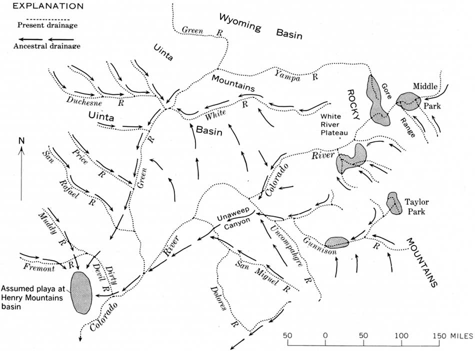
| FIGURE 63.—Possible drainage system in the upper Colorado River basin at the beginning of Miocene time, before intrusions formed the laccolithic mountains. Structural basins that may have contained sluggish drainage, playas, or lakes, are patterned. The Uinta basin drainage is assumed to have overflowed southward to the Henry Mountains basin. The Green and Yampa Rivers were still within the Wyoming basin north of the Uinta Mountains. The courses of most of the rivers in the Rocky Mountains were interrupted, at least intermittently, by the basins and ranges that formed there during middle and late Tertiary time. (click on image for an enlargement in a new window) |
No evidence has been found that indicates when the Henry Mountains basin filled and overflowed southward, but interpretations of the history of the lower stretches of the Colorado River are easier if drainage from the north is delayed as late as possible (p. 113). Partly to relieve problems downstream, it is here assumed that the ancestral Duchesne-White-Gunnison drainage was ponded in the Henry Mountains basin and the next one south of there, the Kaiparowits basin, until Pliocene time, when that drainage was enlarged by addition of the Green River and steady discharge by the main stem of the Colorado.
It has already been noted (p. 83; fig. 55) that the canyon of the Colorado River meanders greatly upstream from its junction with the Green, and that the Green also meanders (fig. 64). The rivers are here flowing against the structural dip of the rocks. After the rivers join, they turn downdip into the Henry Mountains basin in a canyon, Cataract Canyon (fig. 65), that is much straighter than the canyons above the junction.
|
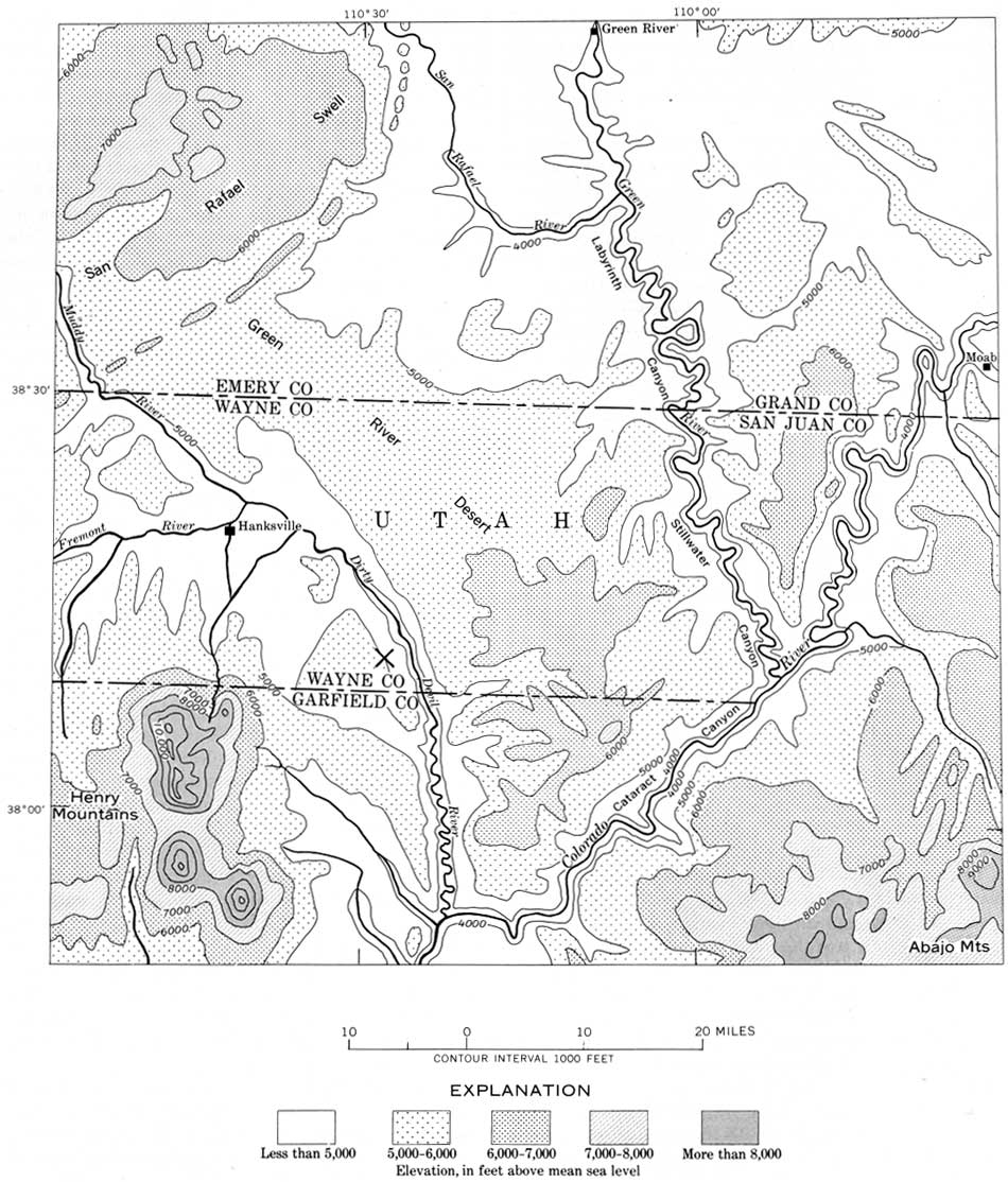
| FIGURE 64.—Meander pattern of the Colorado and Green Rivers above their junction, where the rivers are flowing against the dip of the bedrock. The meandering reaches have gradients averaging less than 1.5 feet per mile. Below the junction, in Cataract Canyon, the Colorado River is flowing down the dip; its course there is much straighter, and the gradient averages 10 feet per mile; X indicates location of gravel deposit, 1,600 feet above the Dirty Devil River. This gravel deposit contains cobbles derived from lava flows (lower Pliocene) in the High Plateaus (to the west) and cobbles of diorite porphyry (probably lower Miocene) from the Henry Mountains. This canyon and the inner gorge of the Colorado River, where it is joined by the Dirty Devil, are no older than middle Pliocene. (click on image for an enlargement in a new window) |

|
| FIGURE 65.—View down Cataract Canyon, where the Colorado River flows down the west flank of the Monument upwarp in a series of cataracts, one of the roughest stretches of water along the Colorado River. |
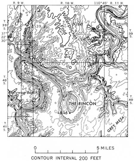
The meandering courses of all the valleys have been maintained during the last thousand feet or so of downcutting. Moreover, many meanders have steep walls on the inside as well as on the outside of the bends; the meander belt has changed very little during canyon cutting. At only two places are there large cutoff meanders of the inner gorge; both are in Glen Canyon, and both are about 500 feet above the river. I assume they are at least as old as early Pleistocene. One is at the mouth of White Canyon, opposite old Hite, 6 miles below the mouth of the Dirty Devil; the other, known as The Rincon, is where the Colorado River crosses the Waterpocket fold (fig. 66).
|
| FIGURE 66.—The Rincon, a cutoff meander in Glen Canyon where the Colorado River crosses the Waterpocket fold. This is an exceptional feature; in general the meanders have not changed greatly while the river has cut downward 1,000 feet. |
The meandering of the inner canyons where the rivers flow against the dip of the rocks suggests that the northward tilting in this part of the Colorado Plateau has continued while the last thousand feet of canyon was being cut. If these stretches of the canyons are partly antecedent, as seems probable, about three-quarters of the depth of the inner canyons might be attributed to downcutting during the Quaternary; cutting of the inner canyon probably began no longer ago than late Pliocene. The wide valley above the stripped Paleozoic formations (fig. 56) involves very much more erosion, and by my interpretation, this erosion would have taken place when the drainage basin and streams were small. I infer that cutting of the outer canyon began at least as long ago as the Miocene, but after intrusion of the laccoliths, because southeastern Utah probably still was largely blanketed by Cretaceous formations (p. 83). This allows about 20 million years for erosion of the outer canyons in the vicinity of the junction of the Green and Colorado Rivers.
As the meander pattern differs above and below the junction of the Green and Colorado Rivers, so do the stream gradients. In 70 river miles above the junction, both rivers have gradients of only about 1.3 feet per mile; in 40 river miles below the junction, along Cataract Canyon, the gradient is 10 feet per mile. Along Glen Canyon, next below Cataract Canyon, the geologic structure is nearly flat except for broad warps (fig. 67); Glen Canyon meanders more than Cataract Canyon but less than the canyons above the junction. The gradient in 180 miles of Glen Canyon is about 1.5 feet per mile. In all three stretches of the canyons, the rocks differ little in their resistance to erosion, the differences in gradient and meander pattern probably reflect responses of the streams to continuing deformation. The relationships are rather like the smaller scale model of the Dolores River where it crosses the Dolores anticline (p. 81).

|
| FIGURE 67.—Glen Canyon (left), now flooded by Lake Powell, is cut into nearly horizontal shale and sandstone (mostly Triassic and Jurassic). At lower right are the incised meanders of the Dirty Devil River just above its junction with the Colorado. The mountains are the two southernmost peaks of the Henry Mountains, Mount Holmes (right) and Mount Ellsworth (left). The distant skyline is formed by the Waterpocket fold. |
The higher and outer canyon walls are set far back from the rim of the meandering inner gorge (figs. 27, 55, 56), and only locally derived fan gravels, not river gravels, were found on the bench between them. The retreat of these cliffs is the result of mass wasting and other erosion along washes and is not attributable to lateral cutting by the rivers. Gravel is resistant compared with much of the bedrock along the canyons, and it is surprising not to find at least some remnants of high-level river gravel along these canyons. Such gravels were sought by air reconnaissance as well as by some ground work and were not found. River gravels are found 1,600 feet above the Dirty Devil River (fig. 64), and there are equally high gravels between the Colorado and San Juan Rivers and farther south. The absence, or at least scarcity of such gravels on the benches bordering the Green and Colorado Rivers near their junctions may reflect the small size of the streams that began the canyon cutting; the tremendous contrast in abundance and extent of gravels in the inner and outer canyons must indicate some kind of change or discontinuity in the river history.
We have noted that when the Uinta basin began to overflow, even though the ancestral Book Cliffs were as far south as the mouth of the Green River, there would have been a plain in Cretaceous shale south of the cliffs at about the altitude of the surface of the Duchesne River Formation. The Henry Mountains basin is 5,000 feet structurally lower than that and could have contained the entire section of Upper Cretaceous beds and 1,000 or 2,000 feet of Tertiary beds. This is about the thickness of beds that Gilbert (1876, p. 94) estimated to have been in the basin when the laccoliths were intruded, and an estimate that I was unable to improve in my survey of the mountains (Hunt and others, 1953, p. 147). The three very different approaches give about the same thickness of beds, which is encouraging in view of the numerous and tenuous assumptions that have to be made in order to interpret drainage history in this part of the Canyonlands.
The basin at the Henry Mountains became smaller when the laccolithic mountains formed, presumably about the same time as the similar La Sal Mountains (25 million years, p. 78), that is, early Miocene. This doming, together with the influx of sediments into the basin, which is small compared with the Uinta basin, could have raised the surface and caused it to overflow around the south end of the Circle Cliffs upwarp into the Kaiparowits basin (fig. 62).
Generally, on the Colorado Plateau the drainage is well adjusted to the laccolithic mountains. The arcuate course of the Fremont and Dirty Devil Rivers around the north end of the Henry Mountains probably reflects drainage adjustment to the doming and to the debris that must have been shed radially off the newly formed mountains. The lower course of the Dolores River also swings in a wide arc around the north side of the La Sal Mountains (fig. 54). San Juan River and the Colorado River, near their junction, swing with the strike of the formations around the northwest side of Navajo Mountain (fig. 29). San Juan River follows the trough of the syncline between the domes at Ute Mountain and Carrizo Mountain (fig. 29). Such adjustment of the drainage to the igneous structures contrasts strikingly with the lack of adjustment to the other folds.
The principal tributaries from the west side of the Green and Colorado Rivers rise in the High Plateaus where uplift occurred in late Tertiary and Quaternary time as well as earlier (Callaghan, 1938, 1939; Gardner, 1941; Averitt, 1964a, b). There is evidence for three major stages of deformation separated by two periods of comparative stability and considerable denudation (Averitt, 1964b, p. 44). Late Cretaceous or early Tertiary folds were bevelled by erosion and overlapped by Ecocene strata, as the Circle Cliffs. The second episode of deformation involved faulting on a major scale beginning in middle Tertiary time; Eocene rocks formed cliffs along the faults. During a subsequent period of comparative stability, the cliffs retreated 8 miles from the faults (Averitt, 1964b, p. 44). The third episode of deformation was represented by renewed faulting in late Tertiary and Quaternary time. Potassium-argon dates suggest an early Pliocene age for some of the volcanic rocks involved in this later faulting (Bassett and others, 1963). The amount of Quaternary uplift may be about 2,000 feet (Hunt, 1956, p. 61); this deformation may be continuing, for there have been seismic epicenters along the west edge of the High Plateaus. Smith and others (1963, p. 61) report displacement during late Wisconsin or Holocene time of at least 160 feet, and probably more, on Thousand Lake fault that crosses the Fremont River near Bicknell. Late Pleistocene deformation in the High Plateaus also has been reported by Hardy and Muessig (1952) and by Spieker and Billings (1940, p. 1192-1193).
Three of the streams draining from the High Plateaus cross the San Rafael Swell, where folding almost certainly began in early Tertiary time (Gilluly, 1929, p. 126-127), but later uplift at the Swell is indicated by the arching of the lower Tertiary formations around the north end of the fold. Three rivers that cross the Swell—the Price, San Rafael, and Muddy—were originally cited as antecedent streams (Dutton, 1882, p. 63), but probably they were superimposed across the Swell from lower Tertiary formations (Davis, 1901, p. 140; Gilluly, 1929, p. 126). All three rivers have steepened gradients where they cross the Swell. These relationships resemble those along the Dolores River and would be expected if the San Rafael River valley had been arched by the late uplift of the Swell.
At several places on the Colorado Plateau, there is evidence that canyon cutting was interrupted and that the streams became superimposed on geologic structures outside their former valleys. The valley of Halls Creek, a strike valley 35 miles long, on the east side of the Waterpocket fold (between the Henry Mountains basin and Circle Cliffs upwarp, fig. 62) is an example. At two places, Halls Creek leaves its strike valley and meanders into canyons cut 500 feet deep in resistant sandstone of the fold. Probably Halls Creek was superimposed on the fold from a shale formation or valley fill, presumably when streamfiow was checked, either by regional northeast tilting of the Colorado Plateau or by local folding or warping. On the basis of height above present drainage, the age of the event is estimated as late Pliocene or early Pleistocene.
Some features of Pleistocene age in this part of the Colorado River drainage basin include the natural bridges (Gregory, 1938; Baker, 1936) and the alcoves and arches (Hunt and others, 1953, p. 171) in the inner canyons. Probably the alcoves containing the prehistoric dwellings at Mesaverde and in the Navajo Country also are Pleistocene features. In late Pleistocene time there must have been snowfields on many of the north-facing cliffs, several of which contain ancient debris avalanches. Two locations of note are about 20 miles southwest of the Abajo (Blue) Mountains (at the Bears Ears) (fig. 29) and about 20 miles farther west (at Fry Canyon). These deposits are deeply dissected and deeply weathered, but they record a middle or late Pleistocene episode when the climate was more moist than now and the canyon walls were mantled with the weathering products of this period.
| <<< Previous | <<< Contents >>> | Next >>> |
pp/669/secc5.htm
Last Updated: 22-Jun-2006