
|
Geological Survey Professional Paper 669
The Colorado River Region and John Wesley Powell |
DESCRIPTIVE GEOLOGY
(continued)
San Juan and Little Colorado Rivers
The hypothesis formulated thus far assumes that drainage from the northern part of the present Colorado River basin did not discharge southward beyond the Henry Mountains or Kaiparowits basins until the end of Miocene time. Until then, the discharge to these basins probably was small because much of the drainage from the Southern Rocky Mountains was repeatedly ponded within the mountains, and Green River was contained somewhere north of the Uinta Mountains. At present rates of discharge, we might suppose that about 3 million acre feet annually reached the Henry Mountains basin (about one-third present discharge; see fig. 30). This amount was divided between two small streams, one from the Uinta basin and the other from the Southern Rocky Mountains. Such a small volume—and there is no reason to suppose it was ever very much greater—might be contained for a long time in a fairly small basin. Natural lakes at middle Tertiary basins may have been extensive enough to dissipate the entire river flow by evaporation.
Stratigraphic evidence on the history of the rivers is found again in the San Juan River drainage basin. This evidence includes a gravel deposit at an altitude of 6,800 feet on White Mesa and other deposits nearby on the Kaibito Plateau south of Navajo Mountain (fig. 68) (Cooley, 1960a; Cooley and Davidson, 1963; this report, fig. 32; Cooley and others, 1969). The gravels include several kinds of Precambrian rocks, volcanic rocks, chert like that contained in Paleozoic formations, locally derived sandstone and conglomerate from Jurassic formations, and fossil shells reworked from basal Upper Cretaceous formations.

|
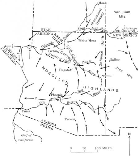
| FIGURE 68.—Four Corners area (from U.S. Geol. Survey, 1932) showing the geologic setting of the gravels of the Kaibito Plateau. The gravels, almost certainly derived from the San Juan Mountains and deposited by a stream flowing southwest, are considered no younger than late Miocene. The San Juan River was across the Monument upwarp and within 75 miles of the Grand Canyon when they were deposited. San Juan basin was a playa during the early Tertiary (Paleocene and Eocene, 65-40 million years ago); discharge from the basin probably began during the Oligocene, perhaps first towards the southwest and then west. (click on image for an enlargement in a new window) |
That the gravel was deposited by a stream flowing southwest is indicated by (1) the crossbeds that dip southwest, (2) the occurrence of reworked fossils (Gryphaea newberryi) from the sandstone (Dakota Sandstone) at the base of the Upper Cretaceous which is east and not west of the gravel, and (3) the occurrence of conglomerate from a Jurassic formation (Morrison Formation) that also is east of the gravel. The deposit has been correlated (Cooley, oral commun. 1965) with erosion surfaces that are older than the Bidahochi Formation, considered to be early and middle Pliocene in age (Lance, 1954). The gravel appears to be of late Miocene age.
The gravels include several kinds of rocks that can be matched in the southwestern part of the San Juan Mountains—pink granite like that in the Precambrian rocks on the south side of the San Juan Mountains (Needle Mountains) and welded tuffs like those in the volcanic rocks of Oligocene and early Miocene age in the central and southwestern part of the San Juan Mountains. The occurrence of these Oligocene and lower Miocene volcanic rocks in the gravels and the apparent absence of younger rock types lends support to Cooley's estimate of the age of the gravel (about middle Miocene), which is based on geomorphology.
Some of the less well rounded Precambrian quartzite, chert, and quartz clasts also could have come from the Precambrian in the San Juan Mountains, but the very well rounded clasts probably are reworked from conglomerates of Permian, Triassic, and Jurassic age. These younger rocks also are exposed in the San Juan Mountains and nearby. Rocks that might have come from a southern or western source were not found. The evidence indicates that the San Juan River flowed across the Monument upwarp (figs. 62, 68) by late Miocene time.
Very similar gravels on the northwest corner of Black Mesa at an altitude of 7,000-7,200 feet (M. E. Cooley, written commun., 1968) probably correlate with those on the Kaibito Plateau.
Marble Canyon, only 40 miles west of the Kaibito Plateau, has been deepened about 3,800 feet since the gravels on the plateau were deposited, for the gravels are that much higher than the Colorado River in Marble Canyon. Stream gravels about the same height above the rivers have also been reported on the plateau west of the head of Marble Canyon, but these gravels are composed only of quartzite (Phoenix, 1963) and probably are from nearby Mesozoic formations. On the rim of Glen Canyon at about the Utah-Arizona State line (just west of the mouth of Wahweap Creek), Phoenix (1963) also found stream gravels consisting of 85 percent quartzite, 13 percent greenish-gray andesite porphyry, and 2 percent various cherts. These gravels probably were reworked from the Wasatch Formation to the west.
The Kaibito Plateau gravels are about 800 feet higher than the rim of the canyon of the San Juan River where it crosses the Monument upwarp; the gravels on Black Mesa are 1,000-1,200 feet higher than the canyon rim. The highest part of the rim is about 6,000 feet in altitude; the fold, where it is crossed by the San Juan River, is only about 5,000 feet high structurally, and some of this structural relief may be due to late Tertiary up-warping. The chances are that in early Miocene time, the fold, like the rest of southeastern Utah, still was covered by Cretaceous formations, and perhaps the river was superimposed across the upwarp from an erosion surface in the thick and easily eroded Cretaceous shale.
The late Miocene drainage lines in the Four Corners area, as inferred by Cooley and Davidson (1963, fig. 10), are given in figure 69. The absence on the Kaibito Plateau of gravels derived from the north may be attributed to possible ponding of the ancestral northern drainage, first in the Henry Mountains basin and later in Kaiparowits basin, or possibly the ancestral drainage already was at the position of Marble Canyon; with this modification, the interpretation by Cooley and Davidson seems more probable than my previous interpretation (Hunt, 1956, figs. 59-61).
|
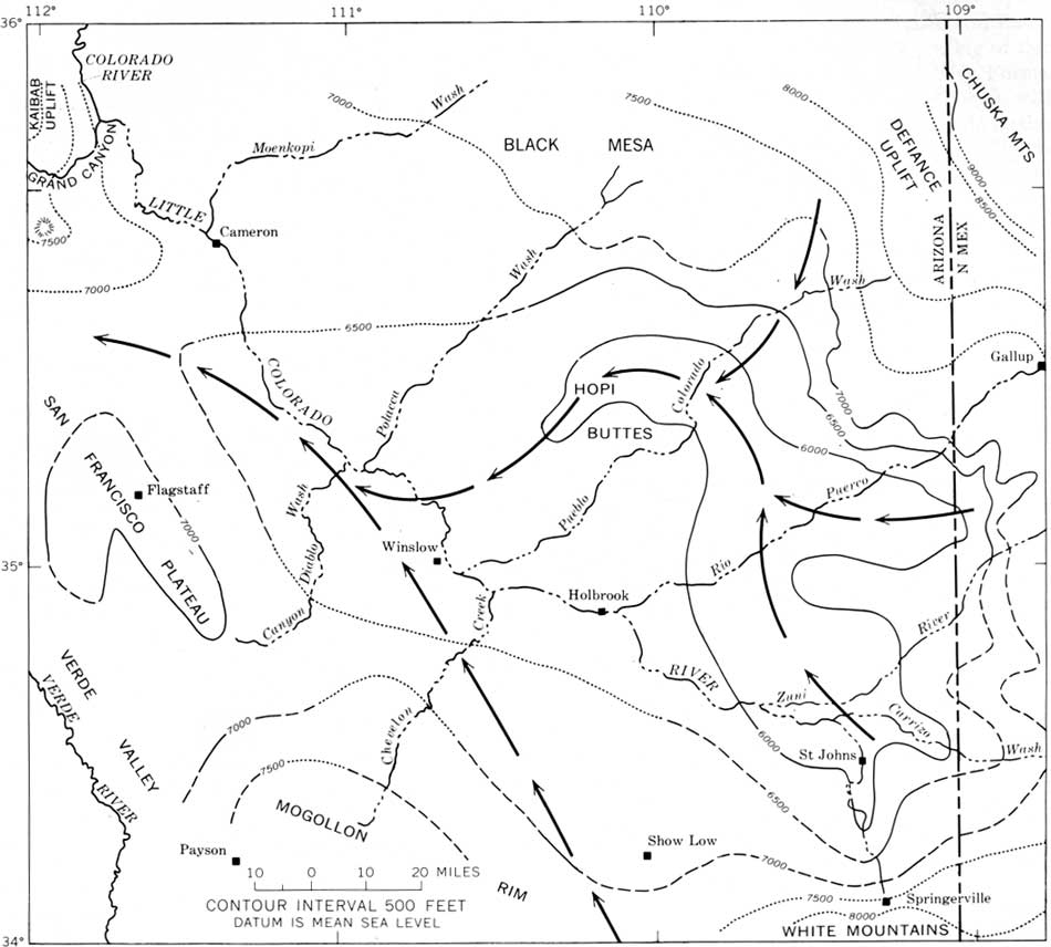
| FIGURE 69.—Drainage directions in Arizona during late Tertiary (late Miocene and early Pliocene) time, as interpreted by Cooley and Davidson (1963, fig. 10). My interpretation of the drainage changes on the Colorado Plateau (the area north of the Mogollon Highlands) is similar except: (1) the headward part of San Juan River (at least as far east as Durango) probably drained southwest rather than southeast; and (2) the Colorado River and its tributaries above the San Juan may have been ponded in the north part of the Colorado River basin until Pliocene time. |
The gradient of the San Juan River steepens where it crosses the Monument upwarp. In 15 miles upstream from Comb Ridge, the river course is straight and its gradient is about 13 feet per mile. In the eastern part of the fold, the river and its canyon meander, and in 15 river miles, the gradient continues about 13 feet per mile. As the river descends the west flank of the fold, the meandering course continues, but beginning near the Goosenecks, the gradient steepens to about 20 feet per river mile. After about 10 miles, the gradient flattens again to about 8 feet per mile, and a comparably low gradient continues to the junction of the San Juan with the Colorado River. Part of this change in river gradient probably is attributable to late Tertiary uplift at the Monument upwarp.
It has been suggested (p. 81) that the ancestral course of the Dolores River, before the intrusion of laccoliths at Ute Mountain, probably was southwest. Possibly the original drainage across the Monument upwarp was by the ancestral Dolores River, and the San Juan may have joined the Dolores as a result of capture. Certainly the drainage pattern suggests that. In Paleocene and Eocene time, drainage off the south side of the San Juan Mountains ended in the San Juan basin and filled it with sediments. When the basin overflowed, the ancestral San Juan River was turned out of it, probably to the west and probably as early as Oligocene time. Whatever its early drainage history, by late Miocene time the San Juan River had established its course across the Monument upwarp.
One of the stratigraphic keys to drainage history in the southern part of the Colorado Plateau is the Chuska Sandstone, but it unfortunately still is a poorly known formation. The sandstone has been correlated with part of the Datil Formation (Wrucke, 1961; also Cooley and Davidson, 1963, p. 24) on the basis of lithologic similarities, particularly the occurrence of heulandite cement and of eolian and fluvial structures that resemble those in the upper part of the Datil. A Pliocene (?) age of the sandstone is indicated.
The sandstone caps the north end of the Defiance upwarp and unconformably overlies the folded Mesozoic formations (figs. 62, 70). Its altitude is 7,650-8,200 feet, which is about 2,500 feet higher topographically than Chinle Wash and about 2,000 feet higher structurally. Some of the difference in structural position probably is due to late Tertiary deformation, but the wide valley of Chinle Wash seems to have been lowered about 2,000 feet since early Miocene time. The ancestral San Juan River may have been superimposed across the Monument upwarp from the equivalent of the Chuska Sandstone in that area. In any event, the course of the San Juan River seems to be younger than the sandstone.

|
| FIGURE 70.—Cross section of the Defiance upwarp. (From Hunt, 1956, fig. 21, modified from Gregory, 1917.) (click on image for an enlargement in a new window) |
The fact that the Chuska Sandstone is preserved on the top of an uplift, rather than in the adjoining basins, yet is nearly horizontal suggests that it was deposited in an anticlinal valley along the crest of that uplift. If so, the topography has become inverted.
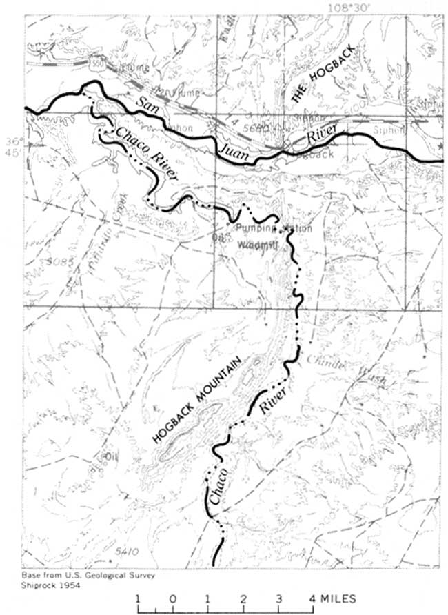
Farther east, where the San Juan River crosses an east-dipping hogback of Cretaceous sandstone (Mesa Verde Group), it is joined by the Chaco River which crosses the hogback at another place (fig. 71). Relationships are similar where Chinle Wash joins the San Juan River. Probably the stream courses were superimposed from a level a few hundreds of feet above the present streams (Hunt, 1956, p. 70). The episodes causing the superimposed valleys at Chaco River, Chinle Wash, and Halls Creek are assumed to have been contemporaneous or nearly so. Accordingly, in the central part of the Colorado Plateau, I infer a late Pliocene or early Pleistocene surface of aggradation or planation about 500 feet above the present drainage and dowucutting of about 2,000 feet below the Pliocene (?) Chuska Sandstone on the Defiance upwarp. Volcanic necks south of the San Juan River are 1,500 feet higher than the present surface around them (for example Ship Rock, N. Mex.; Agathla Peak, Ariz., fig. 68) and have been considered of Pliocene age (Williams, 1936). They may be older than Pliocene because neighboring intrusions that probably are related have been dated radiometrically as Miocene or older (biotite 25 million years; sanidine 40 million years; Akers and others, 1969).
|
| FIGURE 71.—Junction of Chaco and San Juan Rivers. The Chaco, flowing north to join the San Juan, follows a course along the east side of Hogback Mountain formed by east-dipping Cretaceous sandstones. Two miles south of the San Juan River, the Chaco turns through the hogback and the rivers join about 7 miles northwest of the turn. (click on image for an enlargement in a new window) |
The southernmost valley on the Colorado Plateau, that of the Little Colorado River, is unusual in the Colorado River system because it is broad, open, and demonstrably old. It is a strike valley in north-dipping Triassic rocks (fig. 31) and is joined nearly at right angles by long parallel tributaries. Those from the south flow with the dip of the rocks, those from the north flow against the dip, yet the stream patterns are alike.
In the eastern part of the Little Colorado River valley are widespread deposits of limy sand and clay mixed with beds of volcanic ash and some lava, known as the Bidahochi Formation (Hack, 1942; Akers, 1964). The deposits, about 1,000 feet thick, are mostly of fluviatile origin, but the lower part includes some playa and lake beds. They were laid down by streams flowing westward (Hack, 1942; Repenning and Irwin, 1954; McKee and others, 1967). The formation contains vertebrate fossils of Pliocene age (Williams, 1936), the oldest of which are regarded as early Pliocene (Lance, 1954,; J. H. Irwin and others, unpub. data). The valley of the Little Colorado River has been deepened a maximum of only about 500 feet since the Bidahochi Formation was deposited. Clearly, at the end of the Miocene, the Little Colorado River was in a west-draining valley very much like the present one.
Downstream the strike valley skirts the northeast edge of the San Francisco volcanic field, and early lava of the San Francisco field extends into the valley at an altitude of 4,700 feet and only 500 feet higher than the Little Colorado River (Robinson, 1913, pl. 3; Gregory, 1917, pl. 2; Childs, 1948; Colton, 1950, p. 15).
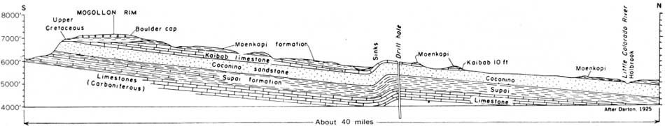
South of the Little Colorado River is a stripped surface on Paleozoic formations that rise to the Mogollon Rim (fig. 72). Much of the stripping occurred during the Mesozoic because the Cretaceous rocks overlap the Triassic and extend onto the Paleozoic. Moreover, the stripping had largely been completed by the beginning of Pliocene time because there has been a maximum of only 500 feet of dowucutting since then.
|
| FIGURE 72.—Cross section showing the stripped surface on Paleozoic formations that rise to the Mogollon Rim south of the Little Colorado River. The Cretaceous rocks overlap Triassic and Permian rocks on the rim, showing that the stripping of the Triassic in this area began in Mesozoic time. The erosion of the Cretaceous rocks was accomplished by the end of Miocene time because lower Pliocene deposits (Bidahochi Formation, not shown in cross section) occur in the valley of the Little Colorado where they are only 500 feet higher than the river. For a more detailed section, see Finnell (1966a, b). (click on image for an enlargement in a new window) |
The altitude of the rim of the Colorado Plateau south of the Little Colorado River is about 7,500 feet, about the same as the rim of the Grand Canyon (fig. 28). The stripped surface has gravels derived from mountains of crystalline rocks to the south. These mountains no longer exist; they have been faulted away from the south edge of the plateau and now are part of the Basin and Range province. At the time those gravels were deposited, their source was higher than the rim of Grand Canyon, and the gravels are 2,000 feet higher than the Little Colorado River towards which they were headed. The gravels clearly were derived from the south and when deposited were in transit northward to the Little Colorado River (McKee, 1951, p. 498; Mears, 1950; Lehner, 1958; Twenter, 1961). Some of these gravels have been correlated with the Bidahochi Formation (Cooley and Davidson, 1963, p. 25) and provide the basis for the drainage positions and directions indicated in figure 69.
The gravels are not well dated but probably are of middle and late Tertiary age. Whatever their age, the topographic relationships in this part of the Colorado Plateau at the end of Miocene time must have been very much as today. It has been suggested that the ancestral Colorado River once flowed southeast along the valley of the Little Colorado and that the drainage became reversed by tilting (McKee and others, 1967). Uplift at the Kaibab upwarp could have ponded the ancestral drainage at the time the Bidahochi Formation was deposited, and this might account for the gravels on the Kaibito Plateau if they are a remnant of a once broad fan. Other gravel deposits south and west of the present Little Colorado River indicate westward drainage before the eruptions at the San Francisco volcanic field; most probably the valley of the Little Colorado River has drained west since middle Tertiary time.
In brief, by middle Miocene time, at least two rivers had reached the head of the Grand Canyon—the Little Colorado River and the ancestral San Juan. If drainage from the north, the ancestral Colorado, also reached there, its course was west of the Kaibito Plateau and probably near the position of the present Marble Canyon.
Originally, the Little Colorado River passed south of the Kaibab uplift (fig. 69) through a gap now having an altitude of 6,800 feet (fig. 73). The upper end of the Grand Canyon is 20 miles north, and the rims there are 1,000 feet higher than the gap. The surface under the Bidahochi Formation slopes eastward (fig. 73). There seem to be three ways in which the Little Colorado River might have crossed the Kaibab uplift: (1) As a result of capture by the San Juan River when the San Juan was already incised across the plateau; (2) as a result of the deposition of 1,000 feet of fill east of the Kaibab uplift, and subsequent removal of this fill; or (3) as a result of 1,000 feet of uplift during and since deposition of the Bidahochi Formation. Probably all three possibilities were factors. Capture seems probable. Post-Bidahochi uplift of the Kaibab Plateau also seems probable. This is suggested by the many faults that displace lava in the north part of the San Francisco volcanic field, (Robinson, 1913, p. 36-37; Cooley, 1960b), and such uplift could cause ponding that would lead to deposition of sediments east of the Kaibab.
|
| FIGURE 73.—Base of the Bidahochi Formation and probable course (arrows) of the ancestral Little Colorado River and its tributaries. Generalized from Cooley and Akers, 1961, p. C247. The high altitude (more than 6,500 ft) of the indicated course through the gap south of the Kaibab uplift is almost certainly due to 1,000 feet or more of uplift at the gap during and since deposition of the Bidahochi Formation. (click on image for an enlargement in a new window) |
The gravels on the Kaibito Plateau (altitude 6,800 ft) are 1,000 feet lower than the present rim of the Grand Canyon, and they project about 1,500 feet lower. The ancestral middle Miocene San Juan River that deposited these gravels may have joined the ancestral Little Colorado River around the south end of the Kaibab uplift, but if so, still another 1,000 feet of fill would be required for the drainages to be superimposed across the Kaibab, again, unless there was later uplift. Because the fill east of the Kaibab would have to be as young as the upper beds of the Bidahochi Formation, differential uplift of the Kaibab Plateau is indicated.
The probabilities are that in middle Miocene time, the Kaibab Plateau—now formed of Kaibab Limestone—was 1,000-1,500 feet lower structurally than it is now. How much Triassic shale persisted above the limestone is unknown. The San Juan River, and questionably the main stem of the Colorado, probably crossed the plateau in a canyon at least hundreds of feet deep. The Little Colorado River, which was in an open valley south of the uplift, could have joined the main drainage west of the Kaibab as a hanging valley, with a waterfall like there is near the mouth of the Little Colorado River today.
| <<< Previous | <<< Contents >>> | Next >>> |
pp/669/secc6.htm
Last Updated: 22-Jun-2006