
|
Geological Survey Professional Paper 669
The Colorado River Region and John Wesley Powell |
DESCRIPTIVE GEOLOGY
(continued)
Grand Canyon—Grand Problem
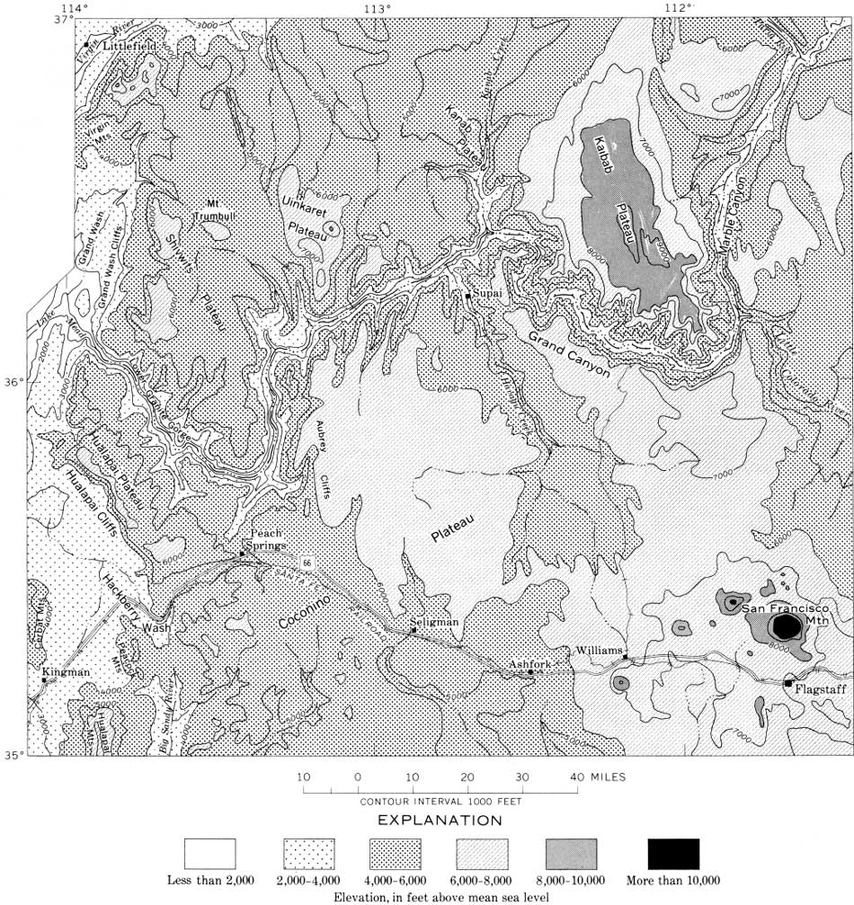
This brings us to the grand problem of the Colorado River, the history of the Grand Canyon (figs. 74, 75). If the interpretations of the structural and drainage histories upstream are approximately correct, Grand Canyon at the Kaibab Plateau was started by the ancestral San Juan River, perhaps in early Miocene time. West of the Kaibab upwarp, the San Juan River joined the ancestral Little Colorado, apparently an older stream that may have eroded canyons west of the Kaibab. At what time they were joined by the drainage passing the Kaiparowits and Henry Mountains basins and by the Green River and headward part of the Colorado is not known, but surely by the beginning of the Pliocene. According to this interpretation, the streams that began cutting Grand Canyon, perhaps in the early Miocene, had a discharge only about one-fifth of the whole river-basin capacity, at present rates of discharge only 2 or 3 million acre feet annually (fig. 30).
|
| FIGURE 74.—Grand Canyon region. About half the difference in altitude between the plateaus and the basins to the west and south is attributed to late Cenozoic uplift of the Colorado Plateau. (click on image for an enlargement in a new window) |
|
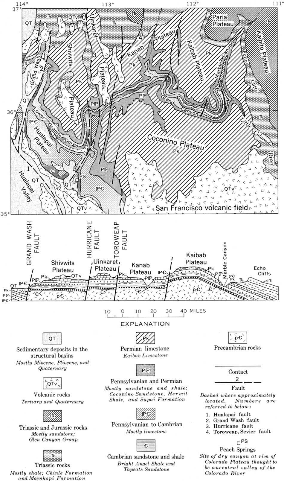
| FIGURE 75.—Grand Canyon region showing the several plateaus. In Eocene time, the Kaibab Plateau was an upwarp with steep east flank and long evenly dipping west flank, similar to the San Rafael Swell, Circle Cliffs, and other upwarps on the Colorado Plateau (fig. 62). In middle Tertiary time, the west flank was broken by several faults. Subsequently, the area between the Kaibab Plateau and the Grand Wash fault was raised; strata in the fault blocks west of the Kaibab Plateau are now nearly horizontal but greatly elevated. (click on image for an enlargement in a new window) |
The foot of the Grand Canyon provides good evidence that no large river discharged there until middle or late Pliocene time. Somewhere between the head and foot of the Grand Canyon we lose 10 or 15 million years of river history, and as it is easier to lose the record of a small river than that of a large one, I favor the interpretation that the streams from the north were held back by ponding in the northern basins until middle Pliocene time.
The evidence for a young date for the Colorado River at the foot of the Grand Canyon has recently been summarized by Ivo Lucchitta (McKee and others, 1967, p. 4, 5). Grand Wash trough was formed by down-faulting of the blocks in and west of the Wash; the Grand Wash Cliffs (fig. 76) mark the western edge of the Colorado Plateau. The displacement by the fault is at least 1 mile and may be as great as 3 miles, depending upon the structures buried by the fill in Grand Wash. Most of the faulting occurred before an upper Miocene fill, the lower part of the Muddy Creek Formation (?), was deposited in Grand Wash. The structural separation of the Colorado Plateau and the Basin and Range province in that area dates from the beginning of that faulting. The lower part of the Muddy Creek Formation in Grand Wash has been correlated, although with considerable uncertainty, with volcanic deposits farther west that are given latest Miocene or earliest Pliocene dates (11.8±0.7 million years, 10.6±1.1 million years; McKee and others, 1967, p. 5).
|
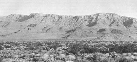
| FIGURE 76.—Grand Wash Cliffs, which form the southwest rim of the Colorado Plateau, near the mouth of the Grand Canyon; one of the highest parts of the Colorado Plateau, both structurally and topographically. Precambrian rocks are exposed at the base of the cliffs; above them are lower Paleozoic strata, mostly limestone. |
The Muddy Creek Formation in Grand Wash was derived mostly from the mountains to the west; it was derived in part from the Grand Wash Cliffs. No Colorado River deposits are known there, and the Colorado River did not discharge into Grand Wash while the Muddy Creek Formation was being deposited (Blackwelder, 1934; Longwell, 1936).
Unconformably overlying the Muddy Creek Formation is a limestone formation (Hualapai Limestone, Longwell, 1936, p. 1429). This is a quiet-water deposit containing very little elastic material and centering near the mouth of the Grand Canyon. The water body probably was a lake but might have been the headward part of an estuary connected with the Gulf of California. (See p. 120.) The Hualapai Limestone is more than 1,000 feet thick (Longwell, 1936, p. 1430), but this thickness may be misleading because the limestone, being an embankment deposit, is confined to the sides of the lake basin. Similar limestone is reported 500 feet or more above the river on both sides of the Grand Canyon near its mouth (Lee, 1908, p. 30, 31), as if the lower few miles of the Grand Canyon antedate the Hualapai Limestone. The limestone has been involved in some of the latest structural movements in Hualapai Wash, but is much less deformed than the underlying Muddy Creek Formation, which in turn is much less deformed than the underlying Paleozoic formations.
The age of the Hualapai Limestone is not known except that it is younger than the Muddy Creek Formation. Post-Hualapai folding and faulting is slight enough to give the impression that the deposit cannot be much older than the earliest Colorado River gravel deposits which are within a few hundred feet of the present river level and also are locally tilted and faulted. Longwell (1936, p. 1475) first inferred that the limestone, which antedates the Colorado River in Grand Wash, was very late Pliocene or even Pleistocene in age; later he supposed (1946, p. 829) that the river there might be as old as late Miocene. I prefer his earlier estimate because the limestone is so much less deformed than the underlying Muddy Creek Formation.
The Hualapai Limestone poses problems. The lake in which it was deposited was at least three times larger than Lake Mead; substantial recharge would be required to maintain the lake against evaporation. If the lake covered 450,000 acres and evaporated 75 inches annually, which probably are conservative estimates, the water surface would lose about 2,750,000 acre feet of water annually, a quantity greater than the combined flow of the present San Juan and Little Colorado Rivers (fig. 30). What was the source of so much water? And what was the source of so much calcium carbonate? If there was a canyon at the lower Granite Gorge, why is there no delta where it discharged into the lake? Even Lake Mead has one! These questions will be considered after looking at the geology of another part of Grand Canyon.
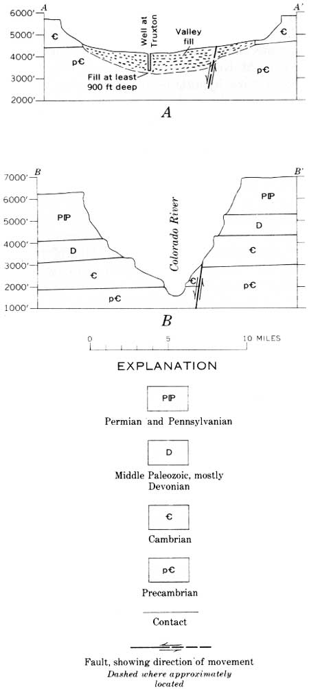
At the upper end of the lower Granite Gorge, where Grand Canyon crosses the Hurricane fault (fig. 75), there is an anomalously wide and deep dry canyon extending southwestward at Peach Springs and breaching the southwest rim of the Colorado Plateau (fig. 77). The dry canyon is alined with the stretch of Grand Canyon that is along the Hurricane fault zone. Its rims average farther apart than do the rims of Grand Canyon in the stretch along the Hurricane fault, and it is half as deep. The valley is filled with gravel, locally derived fanglomerate, lavas, and tuffs, quite like the Muddy Creek Formation.
|
| FIGURE 77.—A, Cross section of the dry canyon breaking the rim of the Colorado Plateau along the Hurricane fault zone. The cross section is at Truxton, which is about 8 miles southwest of Peach Springs. The well at Truxton, 900 feet deep, may have reached the granitic bedrock, B, Cross section of the Grand Canyon in the stretch along the Hurricane fault, 25 miles northeast of A. The formations rise roughly 2,500 feet from B to A, and much of this is probably due to late Tertiary deformation. See figure 79 for location of sections. |
The area has been geologically mapped and described by Twenter (1962) and more recently by Young (1966; summary in McKee and others, 1967, p. 6-9). The sequence of events recorded by the dry canyon and by the fills in it begins with regional tilting of 3°-5° northeast, possibly concurrent with movement along the Hurricane and Grand Wash faults. The canyon was cut by earlier streams that drained south through the now dry canyon. According to Young (1966, p. 7), "Data from wells reveal a deep Cenozoic valley fill (pre-volcanic) near Truxton, Arizona. When corrected for post-volcanic fault movements, the relationship between channel segments suggests, but does not prove, that a Cenozoic stream may have flowed southwest down the ancestral Peach Springs Canyon." (See also Twenter, 1962.) This canyon antedates the Muddy Creek Formation and appears to be older than the mouth of Grand Canyon.
The oldest of the fills in the dry valley and valleys tributary to it are arkosic gravels as much as 400 feet thick. These gravels were derived from the Basin and Range province (fig. 80) and transported northeast onto the plateau (Young, 1966; see also Koons, 1948, p. 59; Koons, in McKee and others, 1967, p. 10; and Krieger, in McKee and others, 1967, p. 15); the drainage then turned southwest off the plateau via the Peach Springs dry valley. After this, according to Young (1966), the valleys became blocked by 300 feet of locally derived talus, fanglomerate, and colluvium. Limestone and limy shale were deposited in valleys where ponding occurred. Some of the fanglomerate seems to have come from the Shivwits Plateau side of the lower Granite Gorge, and if so, this provides evidence that there was no Colorado River in the lower Granite Gorge at that time.
The next higher unit found by Young in the canyon at Peach Springs is a gravel 300-400 feet thick containing crystalline and volcanic pebbles; this suggests reestablishment of northeasterly drainage from elevated Precambrian rocks that later were faulted off that edge of the Colorado Plateau. After this gravel was deposited, volcanism caused lava and volcanic tuff to spread northeast into the dry canyon. A sample of tuff from one of the canyons has yielded a radiometric date of 18.3±0.6 million years before present, that is, middle Miocene (McKee and others, 1967, p. 8). These volcanic deposits blocked southward drainage from the plateau after middle Miocene time.
No undoubted Colorado River gravels have been found in the fill in Peach Springs dry valley, yet a large stream and considerable time were needed to erode so wide a canyon. The absence of Colorado River gravels could be due in part to ponding of the ancestral river at various fault blocks, especially the Kaibab Plateau. Ponding could settle out much or most of the coarse sediment and provide water as clear as that discharging at present at Glen Canyon dam. Further, gravels that could be diagnostic of the San Juan Mountains would be pretty small by the time they were transported as far as the dry valley at Peach Springs, and they may be obscured by the coarse cobble gravels from nearby sources. At present, 95 percent of the gravel being transported by the Colorado River in the Grand Canyon consists of locally derived materials; only 5 percent has upstream sources (M. E. Cooley, unpub. data., 1967). I postulate that the ancestral Colorado River (that is, the ancestral San Juan and Little Colorado) left the Colorado Plateau via the dry canyon at Peach Springs.
The course here postulated for the Colorado River would provide an explanation for the curious Hualapai Limestone at the mouth of Grand Canyon, which required a body of water vastly larger than Lake Mead, highly charged with calcium carbonate and without a source that would deposit elastic sediments. At the Peach Springs depression the river would have been in a canyon in limestone (Redwall, Martin, and Muav Limestones), and the structure of these rocks is such that they are more than 1,000 feet higher at Peach Springs than at the mouth of Grand Canyon; Lower Granite Gorge coincides with a synclinal flexure trending and plunging west-northwest. Water from ponded segments of the river upstream would have been dammed by the fill at Peach Springs and could have discharged through the cavernous limestone to supply springs at the low point of the structure, which is the mouth of Grand Canyon where the maximum deposition of the Hualapai Limestone is centered. Such a mechanism involves piping on a truly grand scale. Some may believe that the scale is outrageous, yet a comparably distant source (50 miles) seems indicated for some of the large springs farther west, in Death Valley (Hunt and Robinson, in Hunt and others, 1966, p. B39-B40). The requirements are fully met along the lower Granite Gorge—an adequate water source with an adequate head over fissured limestone. The postulated piping would provide the large quantity of water required for the lake and the limestone deposited in it and would explain the absence of deltaic deposits in the lake.
The interpretation offered here is that the Grand Canyon at the Kaibab Plateau is pre-middle Miocene and that the canyon cutting there was started by the ancestral San Juan River as the result of superposition before the last 1,500 feet of uplift at the Kaibab Plateau. The older Little Colorado River is postulated to have begun the erosion of the canyons west of the Kaibab Plateau (fig. 69).
This early drainage supposedly left the Colorado Plateau by way of the dry canyon at Peach Springs. According to my interpretation, by middle Miocene time, Grand Canyon was more than 1,000 feet deep and extended from the east side of the Kaibab to somewhere southwest of Peach Springs. Deepening of the canyon was repeatedly interrupted by uplifts of the fault blocks crossing it. By late Miocene time the drainage was blocked from discharging at Peach Springs by uplift of the now dry canyon and by volcanic materials which came into it from the Basin and Range province. The ponded drainage began escaping along fissures in the limestone at the position of the lower Granite Gorge. When the drainage was joined by the Green and Colorado Rivers, the increased discharge could have opened the lower end of Grand Canyon through the limestone. By my interpretation, the Colorado River did not discharge as surface water through the whole length of lower Granite Gorge until after the limestone was deposited.
Downcutting in Grand Canyon during the last half of the Pleistocene has been minimal. At the mouth of Toroweap Valley, lava flows extended into the canyon from the north when the river was within 50 feet of its present position. The lavas, which formed a dam in the inner gorge 600 feet high, are dated at 1.2±0.6 million years before present (Damon, 1965, p. 42, also cited in McKee and others, 1967, p. 14; see also Koons, 1945; Maxson, 1950). If this date is correct, there has been even less dowucutting in Grand Canyon during the Quaternary than has been indicated for the canyons upstream.
Ponding of the rivers upstream from the Kaibab upwarp could be attributed to combinations of four factors, all known to have been operative: (1) Overloading of streams by some climatic event or by volcanic eruptions during late Miocene and Pliocene time; (2) development of the rain shadow east of the High Plateaus (fig. 30) as a result of elevation of the plateaus in Pliocene time; (3) local uplift at the individual folds and at the fault blocks; and (4) northeast tilting of the Colorado Plateau.
Reasons have been given for assuming that about half of the northeast tilting of the Colorado Plateau occurred during the second half of the Cenozoic (p. 99). The southwest rim of the plateau is 20,000 feet higher structurally than the northeast edge (fig. 62). Precise leveling in the Lake Mead area has indicated sinking, apparently because of the load of water in the reservoir, and southwestward tilting of the lake basin (Longwell, 1960, p. 36), as if uplift of the southwest rim of the Colorado Plateau is continuing. Farther north, the Hurricane fault still seems to be active (Averitt, 1964a, table 1). About a quarter (5,000 ft) of the tilting upstream against the direction of flow of the rivers may have occurred during the late Miocene and Pliocene. It does seem that a combination of factors on the Colorado Plateau during Pliocene time could have contributed to greatly diminishing the drainage discharge.
What are some alternative explanations for the Grand Canyon? The possibility that the Colorado River discharged from Grand Canyon before deposition of the Muddy Creek Formation in Grand Wash cannot be completely dismissed simply because no Colorado River gravels have been found beneath the Muddy Creek Formation. A drill hole at any time could reveal them even though the possibility seems unlikely. If the gravels are there, the river must have been ponded on the Colorado Plateau upstream from the Kaibab upwarp while the Muddy Creek Formation was being deposited.
Blackwelder (1934) and Longwell (1936, 1946) assumed that the data for the river across Grand Wash had to apply to the whole river system, and "* * * the river came into existence as a result of the latest great uplift of the Rocky Mountain-Colorado Plateau region, in late Pliocene or early Pleistocene time * * *" (Longwell, 1936, p. 1471). Longwell interpreted the Colorado River as "following essentially its original consequent course" (1936, p. 1471). Later he elaborated on this (1946, p. 833), "If the uplifted Plateau surface was essentially a peneplane, superposition of the new drainage channel across the beveled East Kaibab monocline and other structural features must have started from this surface, along a consequent course determined by topographic. irregularities." We know now that there was no "peneplane," that the canyons are at least as old as middle Miocene, and that the south rim of the plateau was substantially higher than the valley of the Little Colorado River at the end of the Miocene.
Another interpretation of the river history, developed at a symposium in 1964 under auspices of the Museum of Northern Arizona, assumes an ancestral (Miocene?) Colorado River east of the Kaibab Plateau but continuing southeastward along the valley of the Little Colorado River (McKee and others, 1967, p. 52). The reversed drainage in the Little Colorado River valley, according to this interpretation "may possibly have connected with an ancestral Rio Grande * * *" (McKee and others, 1967, p. 54). This ancestral drainage to the southeast then was captured by headward erosion of a stream system heading on the west side of the Kaibab Plateau ("Hualapai drainage system" of McKee and others). According to this theory, the diversion occurred while the drainage was in the easily eroded Triassic formations; increased discharge after diversion enabled entrenchment of the drainage into the more resistant, older rocks forming the present Grand Canyon. In latest Miocene and earliest Pliocene time, according to this theory, the ancestral Colorado River was ponded in the Little Colorado River valley where it contributed to the lake and playa deposits in the lower part of the Bidahochi Formation (fig. 78). This seems likely under either interpretation. Subsequently the west-flowing Hualapai drainage eroded headward across the Triassic formations on the Kaibab upwarp to capture the ponded drainage (McKee and others, 1967, p. 61).

|
| FIGURE 78.—Inferred drainage pattern in northern Arizona when the lower part of the Bidahochi Formation was deposited at the beginning of Pliocene time. Drainage directions largely as interpreted by McKee and others (1967). Arched ancestral valley of the Little Colorado River south of Kaibab upwarp as interpreted by Cooley and Akers (1961). Arched ancestral valley at Kaibab upwarp and underground drainage to Grand Wash are interpretations added in this report. (click on image for an enlargement in a new window) |
The capture hypothesis does not seem to offer advantages over the assumption of an ancient Colorado River having segments that were repeatedly ponded. The assumption of reversed drainage in the Little Colorado valley is unlikely and unnecessary. All the evidence, and there is a lot of it, on the south rim of the Colorado Plateau indicates drainage northward into the valley of the Little Colorado River and into the Grand Canyon. The base of the Bidahochi Formation is 2,000 feet lower than the rim of the Grand Canyon at the Kaibab Plateau, and although this difference could readily be attributed to renewed, late uplift of the Kaibab Plateau, such uplift is against the assumed reversal of the Little Colorado River. To assume no Pliocene uplift at the Kaibab Plateau would require the erosion of a canyon at least 1,500 feet deep to capture the big rivers in the low country east of the plateau. There seems to be no climatic, topographic, or structural reason for the drainage rising west of the Kaibab upwarp to be so precocious. The original course of the Little Colorado River probably was west around the south end of the Kaibab Plateau, as suggested by Cooley (Cooley and Akers, 1961; this report, fig. 47).
No large volume of water could have been discharged at Grand Wash because, as already noted, there was no drainage out of the lower Granite Gorge of the Grand Canyon when the Muddy Creek Formation was being deposited there. The drainage from the plateau could have discharged by way of the canyon at Peach Springs, but that canyon was dammed while the fill in it, which surely is correlative with the Muddy Creek Formation in Grand Wash, was being deposited. Whether by headward erosion of drainage west of the Kaibab, or by the ancient Colorado, the canyon at Peach Springs had already been cut. It is, therefore, older than the valley of the Little Colorado River where filled by the Bidahochi Formation, and it seems to be older than the mouth of the Grand Canyon.
The directions of the early Pliocene drainage postulated by the symposium (McKee and others, 1967) and shown in figure 78 are quite like the pattern I would postulate for that stage of river history. My hypothesis, however, assumes a canyon that had been cut by the ancestral Colorado (San Juan) River across the Kaibab Plateau as the plateau was uplifted (a situation similar to that of Unaweep Canyon where it crosses the Uncompahgre Plateau). At this time, the ancestral drainage discharged from the plateau at Peach Springs. This canyon system that had been cut by the ancestral Colorado River became segmented by the renewed uplift at the Kaibab upwarp, and the lower part was ponded by Miocene and early Pliocene fill in the canyons there.
| <<< Previous | <<< Contents >>> | Next >>> |
pp/669/secc7.htm
Last Updated: 22-Jun-2006